


South America: Continent of Extremes, Cradle of Civilizations
From snow-capped peaks to steaming rainforests, deserts, and wetlands, South America is a diverse continent spanning from Caribbean shores to Tierra del Fuego. With nearly 440 million people, it is home to societies shaped by Indigenous, European, African, and global influences.
 https://www.flickr.com/photos/stignygaard/42875169812")
, https://www.flickr.com/photos/cifor/35742787281")
 https://www.flickr.com/photos/23729107@N04/2986037197/in/photostream/")

 https://www.flickr.com/photos/sorenriise/395861020/")

South America: From the Andes to the Amazon, a Continent Like No Other
South America occupies a triangular landmass of approximately 17.84 million square kilometers (6.89 million square miles) — the world's fourth-largest continent — stretching 7,640 kilometers (4,750 miles) from the sun-scorched Caribbean shores of Colombia and Venezuela in the north to the sub-Antarctic channels of Tierra del Fuego in the south. Within that span, the continent encompasses more geographical variety than any comparably sized landmass on Earth: the world's longest continental mountain range, its largest river by discharge, its driest non-polar desert, its largest tropical wetland, its highest navigable lake, and its most biodiverse terrestrial ecosystem. Twelve sovereign nations and three dependent territories share this space, home to approximately 440 million people whose ancestry and culture draw from Indigenous civilizations that flourished for millennia before European contact, from the enforced migration of millions of enslaved Africans, and from the voluntary settlement of immigrants from every corner of the globe. Understanding South America requires holding all of this simultaneously: the geological deep time, the biological exuberance, the weight of colonial history, and the urgent challenges of the present.
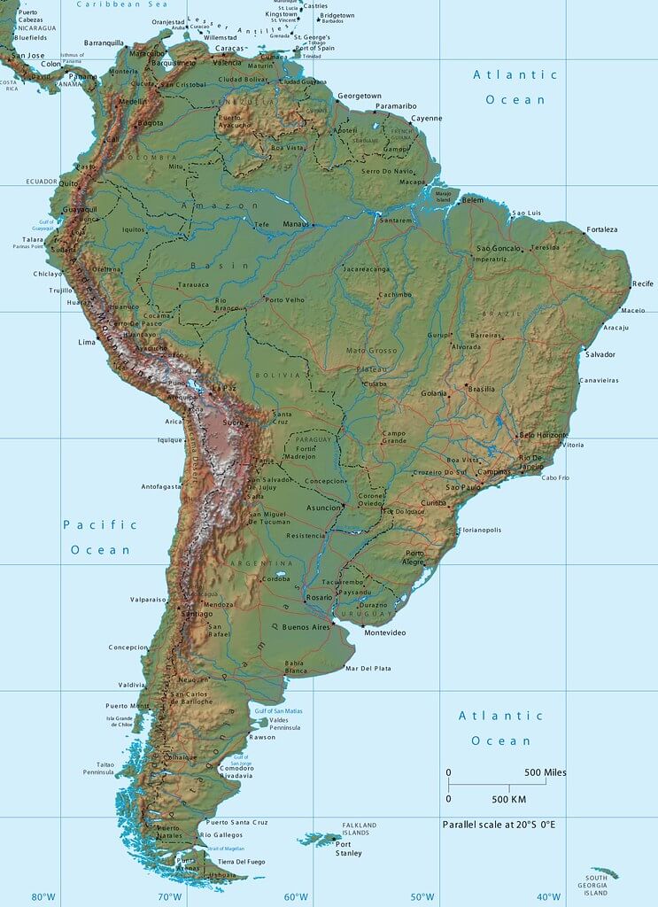
Physiographic map of South America.
Geological Origins: A Continent Adrift
South America's extraordinary geography is the product of a geological history spanning hundreds of millions of years, beginning with the breakup of Gondwana — the ancient southern supercontinent that also included Africa, Antarctica, Australia, India, and the Arabian Peninsula. Gondwana began fragmenting approximately 180 million years ago during the Jurassic period, driven by the upwelling of magma that split the landmass and created new ocean basins. South America remained connected to Africa along what is now the Mid-Atlantic Ridge until roughly 100 to 130 million years ago, when the South Atlantic Ocean opened definitively, and the two continents began their long separation. The fit between the coastlines of northeastern Brazil and West Africa — so precise that early geologists regarded it as compelling evidence for continental drift long before the mechanism of plate tectonics was understood — reflects that ancient connection.
The continent's westward drift brought the leading edge of the South American Plate into collision with the Nazca Plate, a dense oceanic plate being generated at the East Pacific Rise and consumed at the Peru-Chile Trench — a deep-sea feature running along the continent's Pacific margin at depths of up to 8,065 meters (26,460 feet). As the Nazca Plate subducts beneath the South American Plate at a rate of approximately 7 to 8 centimeters (2.8 to 3.1 inches) per year, the friction and pressure force the overlying continental crust upward, generating the Andes and providing the magma that feeds the continent's many active volcanoes. This collision has been building the Andes for roughly 25 million years and shows no sign of stopping: the range continues to rise by millimeters annually even as erosion works to lower it.
The eastern two-thirds of the continent are geologically ancient, resting on two great Precambrian shields — the Guiana Shield in the north and the Brazilian Shield in the center and south — composed of crystalline rocks more than 1.5 billion years old. These stable platforms have been exposed and eroded for so long that they present a subdued topography of plateaus, low ranges, and shallow basins, broken dramatically in the Guiana Shield by the tepuis: flat-topped sandstone mesa mountains whose vertical walls rise hundreds of meters above the surrounding forest, their summits isolated long enough that they have evolved unique plant and animal communities. It is from the tepuis of Venezuela's Canaima National Park that the Churún River plunges off the Auyán-tepui massif as Angel Falls (Kerepakupai Merú), dropping 979 meters (3,212 feet) in a single unbroken fall — the world's highest waterfall, more than 19 times the height of Niagara Falls. The falls were unknown to the wider world until American aviator Jimmie Angel flew over them in 1933; the Indigenous Pemón people had known them for generations and given them a name that translates roughly as "the deepest place."
Between the ancient shields and the young Andes lies the vast sedimentary basin of the Amazon, formed as the continent's interior gradually subsided under the weight of Andean sediments washed eastward over tens of millions of years. This basin covers roughly 7 million square kilometers (2.7 million square miles) — an area larger than Australia — and contains some of the deepest sedimentary sequences on Earth. It is the geological foundation for one of the planet's most remarkable living systems.
The Andes: Spine of a Continent
The Andes extend approximately 7,000 kilometers (4,350 miles) from the Paria Peninsula of Venezuela in the north to Cape Horn and the islands of Tierra del Fuego in the south, making them the world's longest continental mountain range. The system broadens and bifurcates as it moves south: in Colombia and Ecuador it forms a single continuous cordillera, but in Peru and Bolivia it splits into the Cordillera Occidental (western) and Cordillera Oriental (eastern), enclosing between them the high-altitude plateau known as the Altiplano, which extends roughly 800 kilometres (497 miles) through southern Peru and western Bolivia at an average elevation of about 3,750 metres (12,300 feet).
The Andes reach their greatest heights in the Southern Cone. Aconcagua in the Argentine province of Mendoza stands at 6,961 meters (22,838 feet), making it the highest peak in both the Western and Southern hemispheres — a massive stratovolcanic edifice that draws mountaineers from around the world despite the technical simplicity of its normal route, which requires extraordinary acclimatization to the brutal altitude and exposure. Neighboring peaks, including Ojos del Salado (6,893 meters / 22,615 feet), on the Chile-Argentina border, and Monte Pissis (6,795 meters / 22,293 feet) in Argentina, round out the hemisphere's roster of extreme summits.
The range supports a complex suite of high-altitude ecosystems. The páramo — a cold, misty moorland ecosystem found between approximately 3,000 and 4,800 meters (9,840 and 15,750 feet) in the northern Andes of Venezuela, Colombia, Ecuador, and Peru — is one of the world's most unusual plant communities. Its characteristic giant rosette plants of the genus Espeletia, known as frailejones, are adapted to intense ultraviolet radiation, nightly frost, and saturated soils: their dense fur of dead leaves insulates the living crown, and their waxy leaf surfaces minimize water loss. The páramo acts as an extraordinary water tower, its dense vegetation capturing moisture from passing clouds and releasing it steadily into Andean river systems that supply fresh water to tens of millions of people in cities including Bogotá, Quito, and Lima. Above the páramo, the puna grasslands of the Altiplano support the four camelid species of South America — the llama (Lama glama), alpaca (Vicugna pacos), vicuña (Vicugna vicugna), and guanaco (Lama guanicoe) — whose dense, fine fleece is among the warmest natural fibers on Earth. The vicuña, the smallest and wildest of the four, was hunted almost to extinction during the 20th century and reduced to fewer than 6,000 individuals in the 1960s; conservation efforts have since allowed its population to recover to over 350,000.
The eastern slopes of the Andes, known as the yungas or cloud forests, descend from the high puna grasslands through a series of mist-shrouded forest zones of extraordinary biological richness. These slopes intercept moisture-laden air masses rising from the Amazon Basin, producing rainfall that can exceed 3,000 millimeters (118 inches) per year and supporting dense, epiphyte-laden forests that many ornithologists regard as the richest bird habitat on Earth. The Manú department in Peru, encompassing both the Andean cloud forest and the Amazonian lowlands, contains more bird species — over 1,000 — within its protected area boundaries than the entire continental United States.
The Amazon: River and Forest
The Amazon River drains a basin of approximately 7 million square kilometers (2.7 million square miles), encompassing roughly 40% of South America's total land area and portions of nine nations, with the vast majority in Brazil. The river rises in the Peruvian Andes — its most distant headwaters trace to a snowfield on the flanks of Nevado Mismi at 5,597 meters (18,363 feet) — and flows generally eastward for approximately 6,400 kilometers (3,977 miles) before discharging into the Atlantic Ocean near the Brazilian city of Belém. Its average discharge at the mouth is approximately 209,000 cubic meters (7.4 million cubic feet) per second, representing roughly 20% of all the freshwater entering the world's oceans. During the wet season, the river rises by 9 to 14 meters (30 to 46 feet) above its dry-season level, flooding an area of forest the size of England — creating the várzea (seasonally flooded white-water forest) and igapó (permanently flooded black-water forest) ecosystems, each with its own distinct biological communities adapted to months of submersion.
The Amazon Rainforest covering this basin contains an estimated 390 billion trees representing approximately 16,000 species — more tree diversity than all of North America north of Mexico combined. A single hectare of Amazonian forest may contain 300 or more tree species, compared to perhaps 30 in a comparable area of temperate European or North American woodland. The forest stores an estimated 150 to 200 billion metric tons of carbon in its biomass and soils. Its evapotranspiration — the process by which trees draw water up from the soil and release it into the atmosphere through their leaves — generates "flying rivers" of atmospheric moisture that travel westward across the continent, supplying rainfall to agricultural regions of Brazil, Bolivia, Paraguay, and Argentina that are far from any ocean. Scientists have estimated that the Amazon produces roughly half of its own rainfall through this recycling process, meaning that the forest sustains the rain that sustains the forest.
The river system supports biological diversity on a scale that remains incompletely documented. More than 3,000 species of freshwater fish have been described in the Amazon Basin — more than in any river system on Earth, and more than in the entire Atlantic Ocean — with hundreds more awaiting formal scientific description. The arapaima (Arapaima gigas), one of the world's largest freshwater fish, can reach 3 meters (nearly 10 feet) in length and 200 kilograms (440 pounds) in weight; it breathes air through a modified swim bladder and must surface to breathe every 5 to 15 minutes. The Amazon river dolphin (Inia geoffrensis), known locally as the boto or pink river dolphin, is the largest of the world's five freshwater dolphin species and plays an outsized role in Amazonian Indigenous cosmology across dozens of cultures. Black caiman (Melanosuchus niger), the largest predator in the Amazon Basin, can exceed 5 meters (16 feet) in length and was hunted to near extinction for its hides by the mid-20th century before recovering under legal protection. Mammals of the forest include the jaguar (Panthera onca), the giant otter (Pteronura brasiliensis) — which hunts in family groups and communicates with a repertoire of vocalizations so complex that researchers have described it as a form of social coordination — and the giant anteater (Myrmecophaga tridactyla), whose tongue can extend 60 centimetres (24 inches) and whose daily diet of up to 35,000 ants and termites is consumed without ever opening the mouth more than a few millimetres.
Deforestation has destroyed an estimated 17 to 20% of the Amazon's original extent, with the highest rates concentrated in the Brazilian states of Pará, Mato Grosso, and Rondônia along the "arc of deforestation" that advances from the south and east. Scientists have proposed that if total deforestation reaches approximately 20 to 25% of the basin, the reduction in evapotranspiration may push large parts of the remaining forest past a tipping point — a transition from humid rainforest to a drier savanna-like ecosystem that would be essentially irreversible on human timescales. Several research groups have published evidence suggesting that parts of the southeastern Amazon may already be approaching or have crossed this threshold, functioning as net carbon sources rather than sinks in drought years.
Geography of Superlatives
Beyond the Amazon and the Andes, South America's physical geography presents a series of remarkable landscapes. The Atacama Desert, occupying a narrow strip along Chile's Pacific coast between the Andes to the east and the Coastal Range to the west, is the driest non-polar desert on Earth. Its extreme aridity results from a combination of factors: the rain-shadow effect of the Andes, which blocks moisture-bearing air masses from the Amazon; the cold Humboldt Current offshore, which cools maritime air and prevents moisture from rising and condensing into rain; and a persistent subtropical high-pressure system that suppresses precipitation. Some weather stations in the Atacama core have never recorded measurable rainfall over more than a century of record-keeping. Yet the desert is far from lifeless. Halophytic plants have colonized the saltpan margins; the Andean flamingo (Phoenicoparrus andinus) filters brine shrimp from hypersaline high-altitude lakes that shimmer pink and red with algae; and a remarkable array of cacti and fog-dependent lomas vegetation colonizes the coastal hills where Pacific sea mist provides moisture even where rainfall is essentially zero.
The Pantanal, straddling the borders of Brazil, Bolivia, and Paraguay in the upper Paraguay River basin, is the world's largest tropical wetland at approximately 150,000 to 195,000 square kilometers (58,000 to 75,000 square miles) depending on seasonal extent — roughly the size of England and Wales combined. During the wet season between November and March, up to 80% of the Pantanal floods to depths of up to 3 metres (10 feet), creating a vast shallow lake fringed with gallery forest and grassland that supports extraordinary wildlife densities: the world's highest concentration of jaguars, more than 650 bird species, some 300 fish species, and millions of caimans, the sheer number of which makes the Pantanal one of the best places on Earth to observe large carnivores in a natural setting. The giant river otter (Pteronura brasiliensis), the marsh deer (Blastocerus dichotomus), and the giant anteater are all found in the Pantanal in meaningful numbers.
Lake Titicaca, shared between Peru and Bolivia at 3,812 meters (12,507 feet) above sea level, is the world's highest navigable lake and, at 8,372 square kilometers (3,232 square miles), the largest in South America. The lake's thermal mass — it holds an immense volume of water that absorbs solar radiation by day and radiates heat by night — moderates the surrounding altiplano climate enough to make agriculture possible at altitudes where crops would otherwise fail. The Uros people have lived for centuries on floating islands made of totora reeds (Schoenoplectus tatora) on the lake's surface, a form of settlement with no parallel elsewhere in the Americas. The lake is sacred in Andean cosmology: the Inca believed that Viracocha, the creator deity, emerged from its waters to make the sun, moon, stars, and first humans.
The Guiana Highlands of Venezuela, Guyana, Suriname, French Guiana, and northern Brazil constitute one of the world's oldest exposed geological formations and one of its most dramatic landscapes. The tepuis — tabletop mountains whose nearly vertical sandstone walls rise to 1,000 meters (3,280 feet) — were formed when an ancient plateau was eroded over hundreds of millions of years, leaving isolated summits separated by deep valleys. The summits, cut off from the surrounding lowlands since before the dinosaurs, have evolved unique flora and fauna: the carnivorous sundew (Drosera spp.) grows in the nutrient-poor soils alongside endemic bromeliads and orchids; the roraima bush toad (Oreophrynella quelchii) lives only on the summit of Mount Roraima and on adjacent tepuis. These landscapes inspired Arthur Conan Doyle's 1912 novel The Lost World, in which prehistoric creatures survive atop an isolated South American plateau.
Pre-Columbian Civilizations
Archaeological evidence suggests that humans first reached South America at least 14,500 years ago, with the Monte Verde site on the banks of Chinchihuapi Creek in southern Chile providing the most securely dated evidence of early human occupation on the continent. Monte Verde's preservation under a peat bog allowed archaeologists to recover organic materials — wooden stakes, plant foods, animal hides — that paint a picture of a semi-sedentary community eating a varied diet of wild plants, mastodon, and small game, at a latitude equivalent to northern California. The site's age, combined with its location at the extreme southern end of the continent, suggests that humans had been moving through the Americas for a considerable time before Monte Verde was occupied, pushing back the timeline of the hemisphere's initial peopling beyond earlier models.
Over the millennia that followed, South American societies developed extraordinary diversity. The Amazon Basin, long assumed by archaeologists to have supported only small, mobile populations because of the poverty of its tropical soils, is now understood to have sustained large, complex societies in its pre-Columbian past. Recent research using airborne lidar — laser scanning that can detect subtle terrain features beneath forest cover — has revealed extensive networks of earthworks, causeways, and geometric enclosures in the Bolivian Amazon, the Brazilian state of Acre, and elsewhere, suggesting that pre-Columbian Amazonian populations were far larger and more sedentary than the "pristine wilderness" narrative of earlier scholarship admitted. The practice of creating terra preta (dark earth) — deliberately enriching poor tropical soils with charcoal, bone, and organic waste to produce permanently fertile agricultural land — is now recognized as a major Amazonian agricultural technology whose effects persist in the landscape today, millennia after the communities that created it have disappeared.
On the Pacific coast of Peru, the Caral civilization developed in the Norte Chico region between approximately 3000 and 1800 BCE, making it the oldest known civilization in the Americas and one of the six sites where complex civilization developed independently in human history. Caral's monumental architecture — stone platform mounds up to 28 meters (92 feet) high, sunken circular plazas, residential complexes — was being constructed while the Egyptian pyramids were rising and Stonehenge was being built, but with no evidence of writing, ceramics, or military conflict. The Norte Chico civilization apparently organized its economy around the rich anchoveta (Engraulis ringens) fisheries of the cold Humboldt Current, trading dried fish with inland agricultural communities for cotton — used to make fishing nets — and food crops.
The Tiwanaku civilization, centered on the southern shores of Lake Titicaca from approximately 500 to 1000 CE, developed sophisticated raised-field agriculture (suka kollu) on the marshy margins of the lake — a system of ridged planting surfaces separated by water channels that moderated frost risk, retained heat overnight, and created highly productive growing conditions at an altitude where conventional agriculture is extremely challenging. At its peak, Tiwanaku may have supported a population of 350,000 to 500,000 people in its core zone, trading its distinctive polychrome pottery, stone sculpture, and dried foodstuffs across a network spanning much of the Andean world.
The Inca Empire (Tawantinsuyu — "the four parts together") was the largest state in the pre-Columbian Americas and, in terms of geographic extent, the largest in the world at the time of Spanish contact. At its peak in the early 16th century, it stretched approximately 4,000 kilometers (2,500 miles) from what is now southern Colombia to central Chile, encompassing a population estimated at 10-15 million people across an extraordinary range of environments. The Inca administered this empire through a road system extending some 40,000 kilometers (25,000 miles) — constructed without wheeled vehicles, since the wheel was not used in the pre-Columbian Andes — carrying relay runners (chasquis) who could transmit a message from Cusco to Quito, a distance of over 2,000 kilometers (1,240 miles), in approximately five days. Their stone construction, exemplified by the citadel of Machu Picchu perched at 2,430 meters (7,970 feet) above the Urubamba Valley, employed precisely fitted polygonal blocks assembled without mortar, yet so tightly joined that a knife blade cannot be inserted between them — a building technique that has survived centuries of Andean earthquakes that have leveled Spanish colonial structures built nearby.
European Colonization and Its Legacies
The Spanish and Portuguese colonization of South America, which began in earnest in the early 16th century, was one of the most demographically catastrophic events in human history. Francisco Pizarro's conquest of the Inca Empire between 1532 and 1572 was accomplished with a force that never numbered more than a few hundred Spaniards — an outcome made possible by the devastating smallpox epidemic that had swept through the Andes ahead of the Spanish advance, killing the Inca emperor Huayna Capac and triggering a civil war between rival heirs that fatally divided the empire's military response. Across the continent, epidemic diseases to which Indigenous peoples had no prior exposure — smallpox, measles, typhus, influenza — killed an estimated 50 to 90% of the pre-contact population within a century, a demographic collapse without historical parallel in its speed and scale.
The colonial economies of Spanish South America were organized around the extraction of silver and gold. The Cerro Rico mountain at Potosí, in what is now Bolivia, contained the world's largest known silver deposit and was the primary driver of the Spanish colonial economy from the mid-16th century onward. Between 1545 and 1825, Potosí's mines produced an estimated 45,000 metric tons of silver — roughly half of all silver mined worldwide during that period — which was shipped to Spain via the Pacific and used to finance the Habsburg Empire's wars across Europe. The human cost was immense: the mita system of forced labor conscripted Indigenous men from a radius of hundreds of kilometers to work in conditions of lethal danger, and an estimated 8 million people died in the Potosí mines over the colonial period, a toll commemorated in the Mexican and South American Spanish expression "vale un Potosí" (worth a fortune, with its dark irony intact).
Brazil's colonial economy followed a different trajectory, initially centered on brazilwood (Paubrasilia echinata) extraction and later on sugar plantation agriculture in the northeastern coastal zone. The labor demands of sugar production drove the transatlantic slave trade to Brazil on a scale unmatched anywhere in the hemisphere: of the approximately 12.5 million Africans transported across the Atlantic in the entire history of the trade, an estimated 4.8 to 5 million — nearly 40% — were taken to Brazil. The last slave ship arrived in Brazil in 1856, and slavery was not abolished until 1888, making Brazil the last country in the Western Hemisphere to do so. This history of mass enslavement left Brazil with the largest African-descended population outside Africa — roughly 55% of Brazilians today identify as Black or mixed-race — and produced the Afro-Brazilian cultural synthesis of music, religion, cuisine, and language that gives Brazilian culture much of its distinctive character.
Independence from Spain came to most of South America in a concentrated burst between 1810 and 1826, driven by the disruption of Napoleon's invasion of Spain in 1808 and shaped by the military campaigns of Simón Bolívar in the north and José de San Martín in the south. Brazil's independence in 1822 was achieved with less violence, as the Portuguese royal family had relocated to Rio de Janeiro in 1808 to escape Napoleon. When King João VI returned to Portugal, his son Pedro declared Brazilian independence and became Emperor Pedro I — a transition that maintained political continuity rather than rupturing it. The independent states that emerged from colonialism inherited the deeply unequal social structures of the colonial period: landholding concentrated in creole elite hands, Indigenous and Afro-descendant populations legally free but economically marginalized, and institutional frameworks designed for extraction rather than broad-based development.
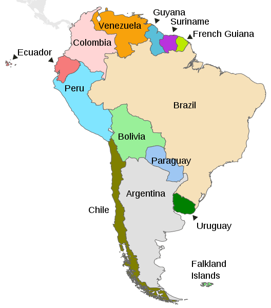
Map depicting the countries on the continent of South America.
Nations and Peoples
South America today comprises twelve sovereign nations and three dependent territories. Brazil dominates the continent in every demographic and geographic dimension: its 8.5 million square kilometers (3.3 million square miles) encompass nearly half the continent's land area, and its population of approximately 215 million represents just under half of all South Americans. Portuguese-speaking Brazil's scale creates a structural reality in which the continent is divided between a single enormous Portuguese-speaking nation and eleven smaller Spanish-speaking republics. This linguistic asymmetry complicates regional integration and is often underappreciated by observers who treat "Latin America" as a culturally homogeneous unit.
Colombia, with approximately 53 million people and coastlines on both the Pacific and the Caribbean, is the only South American nation with access to two oceans. This geographical advantage has historically been offset by the challenges posed by its extraordinarily rugged interior, where three parallel cordilleras of the Andes have separated population centers and hampered national integration for centuries. Colombia's recent history has been defined by a decades-long internal armed conflict among the state, left-wing guerrilla organizations (principally the FARC and ELN), and right-wing paramilitary groups, fueled by competition over the immensely profitable cocaine trade. The 2016 peace agreement between the Colombian government and the FARC, which earned President Juan Manuel Santos the Nobel Peace Prize, formally ended the longest-running guerrilla conflict in the Western Hemisphere — though violence persists in areas where dissident factions and the ELN continue to operate.
Argentina, the continent's second-largest country at 2.78 million square kilometers (1.07 million square miles) and second-most populous at approximately 46 million, presents one of the world's most striking examples of economic underperformance relative to its initial endowments. In 1900, Argentina had one of the highest per-capita incomes in the world, driven by fertile Pampas agricultural exports — beef and grain shipped to European markets via the vast port of Buenos Aires. A century of political instability, military interventions, populist economic mismanagement, and chronic inflation squandered much of that potential. Argentina has defaulted on its sovereign debt nine times since independence, most catastrophically in 2001–2002 when a financial crisis of historic proportions caused output to contract by nearly 11% in a single year and pushed more than half the population into poverty. Yet the country retains extraordinary assets: the most literate and educated population in Latin America, a rich cultural tradition encompassing the tango, the literature of Borges and Cortázar, one of the world's great wine industries centered on Mendoza, and some of the hemisphere's most spectacular natural landscapes from the subtropical jungles of Misiones to the sub-Antarctic channels of Tierra del Fuego.
Peru hosts one of the continent's most complex demographic compositions: a mestizo majority alongside significant Indigenous communities, primarily Quechua-speaking highlanders who account for roughly 25% of the population and maintain agricultural and spiritual traditions that are continuous with the pre-Inca past. The Peruvian Amazon, occupying nearly 60% of the country's territory and home to several dozen uncontacted or voluntarily isolated Indigenous groups whose territories are legally protected, remains one of the least-documented regions on Earth in terms of both biology and human cultural diversity. Lima, the capital, sits improbably in a Pacific coastal desert where virtually no rain falls — its 11 million residents depend on rivers descending from the Andes for their water supply, a dependence that climate change is threatening as Andean glaciers retreat and seasonal water flows become less predictable.
Bolivia and Paraguay are the continent's two landlocked nations. Bolivia's loss of its Pacific coastline to Chile in the War of the Pacific (1879–1884) remains a potent political grievance and a practical economic constraint: Bolivia spends heavily on transit agreements with neighboring countries for access to Pacific ports. The country nonetheless contains extraordinary natural wealth, from the Salar de Uyuni — the world's largest salt flat at 10,582 square kilometers (4,086 square miles), sitting atop lithium deposits that may be the largest on Earth — to the biodiverse lowland forests of the Madidi National Park, which some ecologists consider the most species-rich protected area in the world. Venezuela, once the wealthiest country in South America by per-capita income due to its vast oil reserves — the world's largest proven reserves at approximately 304 billion barrels — has experienced one of the most severe economic collapses in peacetime history under Nicolas Maduro's government, with GDP falling by more than 70% between 2014 and 2021 and an estimated 7 to 8 million Venezuelans having fled the country, constituting the largest displacement crisis in Latin American history.
The three Guiana territories on the continent's northeastern shoulder — Guyana, Suriname, and French Guiana — stand apart from the rest of South America in their colonial heritage and demographic composition. Guyana (British Guiana until 1966) is the continent's only English-speaking sovereign nation; Suriname (Dutch Guiana until 1975) is the only Dutch-speaking country in the Americas; French Guiana remains an overseas department of France, its residents holding French and EU citizenship. All three territories retain large forest cover — Suriname and French Guiana are among the world's most forested countries by percentage of land area — and populations that include Afro-descendant Maroon communities, descendants of enslaved Africans who escaped the coastal plantations in the 17th and 18th centuries and established autonomous communities in the interior rainforest, maintaining West African cultural practices, languages, and governance structures for over three centuries. Guyana has recently emerged as one of the world's fastest-growing economies following major offshore oil discoveries beginning in 2015; its per-capita GDP growth rate in recent years has surpassed that of any other country, raising both extraordinary development opportunities and serious concerns about governance, inequality, and environmental protection in one of the world's most pristine remaining forest nations.
Cultural Landscape
The encounter, collision, and gradual fusion of Indigenous, Iberian, African, and later Asian and Middle Eastern heritages shape South America's cultural identity. Spanish is the primary language of eleven nations; Portuguese is the primary language of Brazil. Yet beneath these colonial languages, a remarkable number of Indigenous tongues survive and, in some cases, thrive. Quechua, the administrative language of the Inca Empire, is today spoken by an estimated 8 to 10 million people across Peru, Bolivia, Ecuador, and neighboring countries, making it the most widely spoken Indigenous language family in the Americas. In Peru and Bolivia, Quechua holds official status alongside Spanish. Guaraní, co-official with Spanish in Paraguay, is spoken by a majority of that country's population — including most monolingual Spanish speakers, who use it in casual conversation — making Paraguay the only nation in the Americas where an Indigenous language functions as a genuine vernacular majority tongue. Aymara, spoken by approximately 2 million people around Lake Titicaca in Bolivia and Peru, preserves a linguistic tradition that predates the Inca Empire.
Music is the cultural form in which South America has most profoundly influenced the wider world. The Argentine tango — born in the working-class conventillos (tenements) of Buenos Aires and Montevideo in the 1880s and 1890s from a fusion of Cuban habanera rhythms, African candombe, and European polka and mazurka — was denounced by the Catholic Church and the Argentine upper classes before becoming the country's most celebrated cultural export, inscribed on UNESCO's Intangible Cultural Heritage list in 2009. Brazilian music encompasses a staggering range of forms: samba, emerging from the Afro-Brazilian communities of Rio de Janeiro in the early 20th century and becoming the pulse of Carnival; bossa nova, invented in the late 1950s by João Gilberto, Tom Jobim, and Vinícius de Moraes as a synthesis of samba rhythm and cool jazz harmony; forró, the accordion-driven dance music of the Northeast; and baile funk, a percussion-driven genre that originated in Rio de Janeiro's favelas and has achieved global influence. Colombian cumbia and vallenato, Peruvian marinera, and Bolivian saya and morenada reflect the continent's regional musical diversity, each genre encoding the specific colonial and Indigenous history of its place of origin.
South American literature achieved global recognition in the second half of the 20th century through the "Boom" — a flowering of innovative fiction, centered on magical realism, that attracted international attention and reshaped the possibilities of the novel form. Gabriel García Márquez of Colombia, whose Cien años de soledad (One Hundred Years of Solitude, 1967) has sold more than 50 million copies and been translated into 46 languages, received the Nobel Prize in Literature in 1982. The Argentine Jorge Luis Borges, whose labyrinths, mirrors, and infinite libraries have influenced writers from Umberto Eco to Jorge Volpi, is widely regarded as one of the most important prose writers of the 20th century. However, he never won the Nobel Prize — a perennial oversight that the Swedish Academy was never able to correct before he died in 1986. The Chilean Pablo Neruda (Nobel laureate 1971) brought Spanish-language poetry to a global readership; the Peruvian Mario Vargas Llosa (Nobel laureate 2010) has produced a body of fiction spanning historical epic, political satire, and erotic comedy that is among the most varied in contemporary world literature.
Roman Catholicism, introduced through often coercive colonial conversion campaigns, remains the professed faith of the majority of South Americans. However, Evangelical Protestantism has grown rapidly across the continent in recent decades, particularly in Brazil, Chile, and the Andean countries. What distinguishes South American Catholicism from its European parent is the depth to which it absorbed Indigenous and African spiritual practices, producing syncretic forms that blended Catholic saints with pre-Columbian deities and Yoruba orishas. Brazil's Candomblé, which maps African religious figures onto Catholic saints while maintaining distinctly West African ritual forms, is practiced by millions and has influenced Brazilian culture far beyond its adherents. In the Andes, the earth goddess Pachamama is venerated alongside the Virgin Mary in forms that reflect centuries of spiritual negotiation between Indigenous communities and the colonial church.
Environmental Challenges and Conservation
South America faces environmental pressures of unprecedented scale and urgency with global consequences, given the continent's disproportionate role in regulating the Earth's climate and sustaining its biological diversity. The Amazon deforestation crisis is the most widely discussed. Still, it exists alongside severe degradation of other critical ecosystems: the Cerrado of central Brazil — a vast tropical savanna covering some 2 million square kilometres (770,000 square miles) that contains approximately 5% of the world's species and has been called "the biodiversity hotspot that no one has heard of" — has lost over half its original vegetation to agriculture, primarily soybean cultivation for export, with far less international attention than the Amazon has received. The Atlantic Forest of eastern Brazil, which once covered 1.5 million square kilometers (580,000 square miles) along the entire eastern coastline, has been reduced to approximately 12% of its original extent — yet still contains over 20,000 plant species, 40% of them endemic, making it one of the most biodiverse fragmented ecosystems on Earth.
Andean glaciers are retreating at rates that alarm hydrologists who study the water security of Andean cities. The Quelccaya Ice Cap in Peru, the largest tropical ice mass in the world at approximately 44 square kilometers (17 square miles), has been retreating at more than 60 meters (197 feet) per year since the 1990s — a rate more than 30 times faster than the rate observed in the 1970s. The glaciers of Bolivia's Cordillera Real supply a significant fraction of La Paz's dry-season water; several smaller glaciers near the city have already disappeared entirely. As the glaciers shrink, seasonal river flows become more erratic, threatening both urban water supplies and Andean agricultural communities whose cropping calendars depend on the reliable timing of meltwater.
Against these pressures, South America has also developed conservation frameworks of global significance. Ecuador became the first country in the world to inscribe the rights of nature in its constitution in 2008, establishing a legal framework in which ecosystems have standing to be defended in court. Bolivia has enacted similar legislation recognizing the rights of Pachamama (Mother Earth). Brazil's protected area system, if fully enforced, encompasses one of the world's largest networks of conservation units — though enforcement has been chronically under-resourced and political will has fluctuated dramatically between administrations. Indigenous territories, which in Brazil alone cover approximately 117 million hectares (289 million acres), consistently show lower deforestation rates than surrounding areas, making their legal recognition and defense one of the most cost-effective conservation strategies available. The Yasuní National Park in Ecuador's Amazon, covering approximately 9,820 square kilometers (3,792 square miles), has been identified as possibly the most species-rich place on Earth: studies have found more tree species in a single hectare than in all of North America, and more amphibian and reptile species than anywhere else on the continent.
Conclusion
South America rewards close attention in ways that few continental-scale geographies can match. It is a place where geology operates on timescales that dwarf human history — where a mountain range is still actively rising, and a river basin is still filling with sediment — yet where the consequences of human choices made in the past five centuries, and the choices being made today, will determine what survives of an extraordinary natural and cultural inheritance. The continent gave the world the potato (Solanum tuberosum), the tomato (Solanum lycopersicum), chocolate (Theobroma cacao), quinine from the bark of Cinchona trees, the rubber tree (Hevea brasiliensis), and hundreds of other species that have transformed global agriculture, medicine, and industry. It is home to the highest, longest, driest, largest, and most diverse natural systems in the hemisphere, and to human cultures whose intellectual and artistic accomplishments have enriched the world far beyond their geography. Whether the continent's biological richness, its climate-stabilizing function, and the well-being of its people can be secured amid the turbulence of the 21st century is one of the most consequential questions facing humanity as a whole.