The Urubamba Valley: Sacred Heart of the Inca Empire
Nestled within the rugged embrace of the Peruvian Andes lies the Urubamba Valley, also known as the Sacred Valley of the Incas. This enchanting landscape, etched with the passage of the Urubamba River, is a testament to the enduring legacy of ancient civilizations that once flourished here.
 https://www.flickr.com/photos/aolinex/3274940828")
 via Wikimeida Commons")
 via Wikimedia Commons")
 via Wikimedia Commons")
 via Wikimeida Commons")
 https://www.flickr.com/photos/tydence/27536487501")
Urubamba: Heart of the Inca Empire and Cradle of Andean Civilization
In the heart of Peru's Andes, where snow-capped peaks rise above 6,000 meters (19,685 feet) and ancient rivers carve pathways through time, lies one of South America's most archaeologically significant landscapes. The Urubamba Valley, revered by the Incas as the Sacred Valley, extends 100 kilometers (62 miles) from the town of Pisac southeast to Ollantaytambo, following the serpentine course of the Urubamba River through elevations that range from 2,050 meters (6,726 feet) near Machu Picchu to 3,700 meters (12,139 feet) at the valley's highest settlements.
This remarkable corridor, averaging 1-2 kilometers (0.6-1.2 miles) in width along its fertile floor, served as the agricultural and spiritual heartland of the Inca Empire. UNESCO's recognition of the valley as part of the Historic Sanctuary of Machu Picchu acknowledges not only its archaeological treasures but also its ongoing role as a living cultural landscape, where Indigenous Quechua communities continue to maintain traditions that date back over five centuries.
Geographic Foundation: River, Valley, and Sacred Peaks
The Urubamba River, known to the Incas as Willkamayu or "Sacred River," originates from the glacial meltwaters of the Cordillera Urubamba, flowing northwest through the valley before eventually joining the Amazon Basin. The river descends approximately 1,650 meters (5,413 feet) over its course through the Sacred Valley, creating diverse microclimates that the Incas exploited for agricultural experimentation and specialization.
Geological surveys reveal that the valley's formation began approximately 10 million years ago through tectonic uplift and subsequent glacial carving during the Pleistocene epoch. The resulting landscape features dramatic contrasts: broad alluvial plains perfect for cultivation, flanked by steep-sided mountains that rise abruptly from the valley floor. These geological processes created natural amphitheaters and defensive positions that Inca engineers incorporated into their settlement planning.
The valley's orientation follows a northwest-southeast axis, creating optimal sun exposure throughout the day while providing natural protection from harsh weather systems. Towering peaks, including Sahuasiray (5,818 meters/19,088 feet), Veronica (5,893 meters/19,334 feet), and Chicon (5,530 meters/18,143 feet), serve as both geographical landmarks and sacred apus (mountain spirits) in Andean cosmology, their snow-covered summits providing year-round water sources through glacial melt.
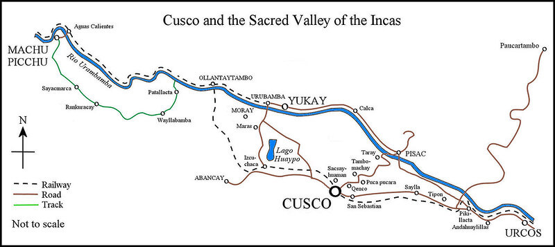
Map depicting the Sacred Valley in Peru.
Climate and Seasonal Rhythms
The Sacred Valley experiences a highland tropical climate characterized by distinct wet and dry seasons, which profoundly influenced the Inca agricultural and ceremonial calendars. The dry season, which extends from May to September, brings clear skies, cool nights with an average temperature of 5°C (41°F), and warm days that reach 20°C (68°F). These conditions create ideal circumstances for harvesting and preservation of crops, as well as optimal visibility for astronomical observations crucial to Inca timekeeping.
The wet season, from October through April, delivers approximately 600-800 millimeters (24-31 inches) of annual precipitation, primarily through afternoon thunderstorms that nourish crops while minimally disrupting daily activities. The Incas developed sophisticated drainage systems and terracing techniques to manage this seasonal water abundance, preventing erosion while maximizing agricultural productivity.
Temperature variations create distinct ecological zones within the valley. The warmer, lower elevations near Ollantaytambo support cultivation of maize (Zea mays), beans, and squash, while higher elevations favor potatoes, quinoa (Chenopodium quinoa), and other cold-resistant Andean crops. Modern meteorological data indicate that the valley experiences approximately 300 clear days annually, contributing to its reputation as an ideal location for both agriculture and tourism.
Flora and Fauna: Biodiversity in the Sacred Landscape
The Sacred Valley's diverse elevations and microclimates support remarkable biodiversity that ranges from humid cloud forest elements to high-altitude grasslands. The native Polylepis forests, found at elevations above 3,500 meters (11,483 feet), represent one of the world's highest-altitude tree ecosystems. These distinctive reddish-barked trees (Polylepis racemosa and P. incana) provided crucial resources for Inca construction and fuel, while their twisted forms inspired artistic motifs found throughout Inca textiles and ceramics.
Traditional agricultural terraces continue to support heirloom varieties of crops that originated in this region. Archaeological botanists have identified over 100 native potato varieties (Solanum species) still cultivated using pre-Columbian techniques. Purple corn (Zea mays var. amylacea), sacred to the Incas for its deep color symbolizing the night sky, grows alongside ancient varieties of quinoa that provided complete protein for high-altitude populations.
Wildlife adapts remarkably to the valley's vertical ecosystem. The Andean condor (Vultur gryphus), sacred to Inca cosmology as a messenger between earthly and celestial realms, soars on thermal currents above the valley, its 3-meter (10-foot) wingspan visible against the mountain backdrop. Vicuñas (Vicugna vicugna), prized for their ultra-fine wool, graze on high grasslands above 4,000 meters (13,123 feet), while spectacled bears (Tremarctos ornatus) inhabit cloud forest margins where they feed on bromeliad hearts and native fruits.
Smaller species reveal the valley's ecological richness. The Andean cock-of-the-rock (Rupicola peruvianus), Peru's national bird, displays its brilliant orange plumage in humid ravines, while giant hummingbirds (Patagona gigas) hover around native Puya flowers at elevations exceeding 3,800 meters (12,467 feet). Mountain chinchillas (Chinchilla chinchilla) inhabit rocky crevices, their dense fur enabling survival in extreme temperature variations.
Sacred Geography: Cosmology and Landscape
Understanding the Sacred Valley requires recognizing that for the Incas, the landscape possessed profound spiritual significance that transcended mere geographical features. The valley's designation as "sacred" stems from its role in Inca cosmology, where the Urubamba River represented the earthly reflection of the Milky Way, flowing through a terrestrial version of the celestial realm.
The Incas identified numerous huacas (sacred places) throughout the valley where the spiritual and physical worlds intersected. These included natural rock formations, springs, mountain peaks, and caves that served as focal points for ceremonies, offerings, and astronomical observations. The distribution of major archaeological sites follows precise astronomical alignments, with temples and ceremonial platforms oriented toward solstice sunrises, lunar standstills, and the appearance of key constellations.
Ritual practices centered on maintaining ayni (reciprocity) between human communities and the natural world. Ceremonies honoring Pachamama (Mother Earth) and the apu (mountain spirits) continue today, with Indigenous communities offering coca leaves, chicha corn beer, and elaborate despachos (ritual offerings) at sacred sites throughout the valley. These practices maintain spiritual relationships that predate European contact by centuries.
The valley's water sources held particular significance, with springs and river confluences serving as focal points for purification rituals and offerings to water spirits. The Incas constructed elaborate water management systems that served both practical and ceremonial purposes, channeling sacred waters through temples and ceremonial baths that connected users with divine forces.
Archaeological Treasures: Windows into Inca Civilization
The Sacred Valley boasts the highest concentration of significant Inca archaeological sites outside Cusco, each revealing distinct aspects of imperial administration, religious practices, and architectural innovations. These sites, connected by the Qhapaq Ñan (Inca road system), functioned as an integrated network supporting the empire's economic, political, and spiritual activities.
Machu Picchu: The Lost Citadel. Perched at 2,430 meters (7,972 feet) on a narrow ridge above the Urubamba River, Machu Picchu represents the pinnacle of Inca architectural achievement. Built during the reign of Pachacuti (1438-1472 CE), this royal estate covers 13 square kilometers (5 square miles) and contains over 200 structures organized into distinct urban, agricultural, and ceremonial sectors.
The citadel's Intihuatana stone, precisely carved to track solar movements throughout the year, demonstrates sophisticated astronomical knowledge that governed agricultural and ceremonial calendars. Archaeological evidence suggests the site supported a population of approximately 1,000 residents, including nobility, priests, artisans, and agricultural specialists who maintained the extensive terraced gardens that still function today.
Pisac: Guardian of the Valley's Entrance. Commanding the southeastern approach to the Sacred Valley, Pisac's archaeological complex spans four distinct sectors across 9 square kilometers (3.5 square miles) of dramatic Andean terrain. The site's name derives from p'isaqa, the Quechua word for partridge, reflecting the stepped agricultural terraces that resemble the bird's plumage when viewed from above.
The ceremonial center, located at an elevation of 3,300 meters (10,827 feet), features the remarkable Intihuatana complex, where precisely cut stones create astronomical observation points aligned with solstice events. Over 500 agricultural terraces demonstrate Inca expertise in slope stabilization and microclimate creation, supporting crops from tropical valleys to high-altitude plains within a single site.
Ollantaytambo: The Living Inca Town. Ollantaytambo stands out among the Sacred Valley sites as a continuously inhabited settlement where Quechua families still reside in structures built on the original Inca foundations. The town's grid pattern, oriented to optimize solar exposure and drainage, reflects sophisticated urban planning principles that remain functional after five centuries.
The Temple of the Sun, constructed from massive pink granite blocks quarried 6 kilometers (3.7 miles) away across the valley, showcases Inca engineering capabilities. Each block, weighing up to 50 tons, required precise cutting, transportation, and placement using techniques that modern engineers struggle to replicate. The temple's unfinished state, which was abandoned during the Spanish conquest, provides insights into Inca construction methods that are rarely visible at completed sites.
Moray: Laboratory of Ancient Agriculture. The circular terraces of Moray, carved into natural depressions at an elevation of 3,500 meters (11,483 feet), represent one of the world's most sophisticated pre-Columbian agricultural experiments. Three main amphitheater-like structures create microclimates with temperature variations of up to 15°C (59°F) between upper and lower levels, enabling the cultivation of crops from different ecological zones within a compact area.
Recent archaeological research suggests these terraces served as agricultural research stations where Inca botanists developed new crop varieties and tested cultivation techniques before implementing them throughout the empire. The largest circle, reaching 30 meters (98 feet) in depth, contains 12 concentric terraces that demonstrate precision engineering and a deep understanding of high-altitude agriculture.
Maras: Salt of the Empire. The salt evaporation ponds of Maras, active for over 500 years, illustrate the Incas' exploitation of natural resources for the imperial economy. Fed by underground springs containing high concentrations of dissolved minerals from ancient geological formations, these terraced pools produce salt through evaporation techniques that require precise water management and timing.
Approximately 3,000 individual pools, averaging 5 square meters (54 square feet) each, cascade down the mountainside in geometric precision. Local families maintain hereditary rights to specific pools, continuing traditional harvesting methods that produce salt with unique mineral content prized throughout Peru for its flavor and supposed medicinal properties.
Traditional Agriculture: Innovation and Continuity
The Sacred Valley's agricultural systems represent one of humanity's most successful examples of sustainable mountain farming, supporting dense populations for over a millennium while maintaining soil fertility and preventing erosion. Inca agricultural innovations, refined over centuries of experimentation, continue to inform modern permaculture and sustainable farming practices worldwide.
Terraced agriculture, known as andenes in Spanish or pata pata in Quechua, transforms steep mountainsides into productive farmland while preventing soil erosion and managing water distribution. These engineering marvels, built without metal tools or beasts of burden, required moving millions of tons of soil and stone to create level planting surfaces supported by precisely fitted retaining walls.
Modern analysis reveals the sophisticated engineering behind terrace construction. Foundation stones, some weighing several tons, provide drainage while smaller stones create filtration layers that prevent waterlogging. The terraces' slight inward slope ensures optimal water retention while excess moisture drains through carefully engineered channels that prevent erosion during heavy rainfall.
Crop rotation and companion planting techniques developed in the Sacred Valley maximized productivity while maintaining soil health. The Incas practiced vertical archipelago farming, cultivating different crops at various elevations to spread risk and optimize growing conditions. Lower elevations produced maize and vegetables, while middle elevations specialized in potatoes and quinoa. The highest areas supported hardy grains and root crops that could withstand frost.
Indigenous communities continue these practices today, maintaining seed banks of heirloom varieties that possess genetic adaptations to specific microclimates. The Potato Park, a community-managed conservation area near Pisac, protects over 600 native potato varieties, representing one of the world's most diverse collections of this globally important crop that originated in the Andes.
Cultural Practices: Living Heritage in the Sacred Valley
Contemporary life in the Sacred Valley maintains strong connections to pre-Columbian traditions, with Quechua-speaking communities preserving language, customs, and spiritual practices that have evolved continuously since Inca times. These living traditions provide cultural context for understanding how ancient sites functioned within broader social and religious frameworks.
The agricultural calendar continues to govern community life, with festivals and ceremonies marking planting, growing, and harvest seasons. Inti Raymi, the Festival of the Sun, celebrated each June solstice, honors the sun god Inti through elaborate ceremonies that recreate Inca rituals at Sacsayhuamán and other sacred sites in the Sacred Valley. Communities throughout the valley participate in these celebrations, wearing traditional textiles and performing dances that have been passed down through generations.
Traditional textile production remains central to cultural identity, with each community maintaining distinctive patterns and techniques that identify their geographic and social origins. Women spin wool from native alpacas and llamas using wooden spindles while walking to markets or tending animals, creating threads that will become carrying cloths, ceremonial garments, and everyday clothing decorated with symbols that encode cultural knowledge.
Andean reciprocity, the social system of mutual obligation known as ayni, continues to organize community labor for agricultural tasks, construction projects, and ceremonial activities. During the planting and harvest seasons, extended family networks cooperate in rotating labor parties, ensuring that all community members receive necessary assistance while strengthening social bonds.
Traditional medicine, based on plant knowledge accumulated over centuries, addresses both physical ailments and spiritual imbalances. Curanderos (traditional healers) utilize native plants, such as coca leaves (Erythroxylum coca) and Lepidium meyenii (maca), along with various highland herbs, in combination with ceremonial practices that aim to restore harmony between individuals and their natural environment.
The Cusco Connection: Imperial Capital and Sacred Hinterland
The Sacred Valley's relationship with Cusco extends far beyond geographical proximity, representing a carefully planned integration of imperial capital with agricultural heartland that sustained the Inca Empire's expansion throughout the Andes. Located 15 kilometers (9.3 miles) northeast of Cusco at a lower elevation, the valley provided the city's elite with agricultural products, ritual spaces, and seasonal residences that complemented urban life.
The Qhapaq Ñan road system connected Cusco with every major Sacred Valley site through paved highways that enabled rapid communication and transportation of goods throughout the imperial core. These roads, engineered to accommodate foot traffic, llama caravans, and ceremonial processions, featured rest stations, storage facilities, and administrative centers that maintained imperial control over this crucial region.
Cusco's nobility maintained country estates throughout the Sacred Valley, with royal ayllus (kinship groups) controlling specific territories and their associated agricultural production. Machu Picchu served as Pachacuti's personal estate, while other sites like Chinchero and Ollantaytambo functioned as royal residences where Inca rulers could escape the capital's administrative demands while remaining connected to imperial affairs.
The valley supplied Cusco with specialized agricultural products that could not be grown at the capital's higher elevation. Maize, essential for chicha production, used in state ceremonies and elite consumption, grew abundantly on Sacred Valley terraces. Tropical fruits and coca leaves, transported from even lower elevations, passed through the valley on their way to Cusco markets and ceremonial centers.
Administrative integration ensured that Sacred Valley communities contributed labor and resources to imperial projects while receiving protection, infrastructure development, and access to goods from throughout the empire. This reciprocal relationship enabled the Incas to maintain intensive agriculture that supported dense populations, while also funding military campaigns and construction projects that expanded imperial territory.
Modern Challenges: Conservation and Sustainable Development
Today's Sacred Valley faces complex challenges balancing archaeological preservation, Indigenous rights, environmental protection, and economic development pressures generated by international tourism. Over 400,000 visitors annually travel through the valley en route to Machu Picchu, creating both opportunities and threats for local communities and archaeological sites.
Tourism provides crucial income for valley residents, with many families operating small hotels, restaurants, and guide services that enable them to remain in traditional communities rather than migrating to urban areas. However, increased visitation also strains infrastructure, threatens archaeological sites, and can commodify cultural practices in ways that undermine their authentic meaning and significance.
Climate change presents emerging challenges for high-altitude agriculture and water resources that have sustained Sacred Valley communities for centuries. Glacial retreat in the Cordillera Urubamba reduces dry-season water availability, while changing precipitation patterns disrupt traditional agricultural calendars that have guided planting decisions for generations.
Conservation efforts focus on maintaining the integrated landscape that encompasses archaeological sites, traditional agriculture, and natural ecosystems. The Historic Sanctuary of Machu Picchu protects 32,592 hectares (80,535 acres) of the Sacred Valley's most significant areas, while buffer zones and community conservation agreements extend protection to additional territories.
Local communities are increasingly involved in tourism management and archaeological site interpretation, offering authentic cultural experiences while generating income that supports traditional livelihoods. Community-based tourism initiatives enable visitors to learn about Andean agriculture, textile production, and ceremonial practices directly from the practitioners themselves, rather than relying on external interpreters.
Research and monitoring programs assess the impacts of tourism on archaeological sites and develop management strategies that protect cultural resources while accommodating visitor access. New technologies, including drone surveys and 3D modeling, enable detailed site documentation and monitoring that supports both research and conservation planning.
Contemporary Significance: Lessons from the Sacred Valley
The Sacred Valley's enduring significance extends beyond its role as a tourist destination or archaeological preserve, offering insights into sustainable mountain agriculture, community resilience, and the integration of human settlements with challenging natural environments. As global climate change threatens mountain communities worldwide, the valley's traditional practices provide tested strategies for adaptation and survival.
Indigenous knowledge systems preserved in Sacred Valley communities represent centuries of accumulated wisdom about high-altitude agriculture, weather prediction, and resource management. These practices, developed through continuous experimentation and refinement, offer alternatives to industrial agriculture that may prove essential for feeding growing populations while protecting environmental resources.
The valley's demonstration of successful cultural continuity across five centuries of political upheaval provides models for maintaining Indigenous identity while adapting to changing circumstances. Quechua communities have selectively adopted beneficial innovations while preserving their core cultural values and practices, which define their relationship to the landscape and to one another.
Archaeological research in the Sacred Valley continues to reveal new insights into Inca achievements in engineering, astronomy, agriculture, and social organization. Recent discoveries using ground-penetrating radar and satellite imagery suggest that many sites contain unexplored sections that may revolutionize understanding of Inca civilization and its relationships with earlier Andean cultures.
The valley's integration of multiple functions—agriculture, residence, ceremony, defense, and administration—within a coherent landscape design offers valuable lessons for contemporary regional planning, which seeks to balance economic development with environmental protection and cultural preservation. The Incas' success in creating sustainable mountain settlements that supported large populations while maintaining ecological health inspires modern communities facing similar challenges.
Conclusion: The Eternal Sacred Valley
The Urubamba Valley endures as more than a repository of archaeological treasures or a showcase of spectacular Andean scenery. It represents a living demonstration of how human communities can create enduring relationships with challenging mountain environments through innovation, cooperation, and respect for natural systems. The valley's designation as sacred reflects not only its role in Inca cosmology but also its ongoing function as a landscape where ancient wisdom continues to guide contemporary life.
As morning mist rises from the Urubamba River and sunlight illuminates the terraced mountainsides that have supported human communities for over a millennium, the Sacred Valley reveals itself as both a historical artifact and a contemporary homeland. Its stone walls and water channels carry forward engineering knowledge that modern practitioners struggle to replicate, while its fields and communities maintain cultural practices that offer guidance for sustainable living in an uncertain future.
For the Quechua families who continue to call the Sacred Valley home, and for the hundreds of thousands of visitors who experience its remarkable synthesis of natural beauty and human achievement, the valley provides an irreplaceable opportunity to witness how cultural heritage can remain vibrant and relevant across centuries of change. In walking its ancient paths, observing its traditional practices, and contemplating its spiritual significance, we encounter not merely the remnants of a vanished civilization but a continuing demonstration of human possibility in one of the world's most challenging and beautiful landscapes.
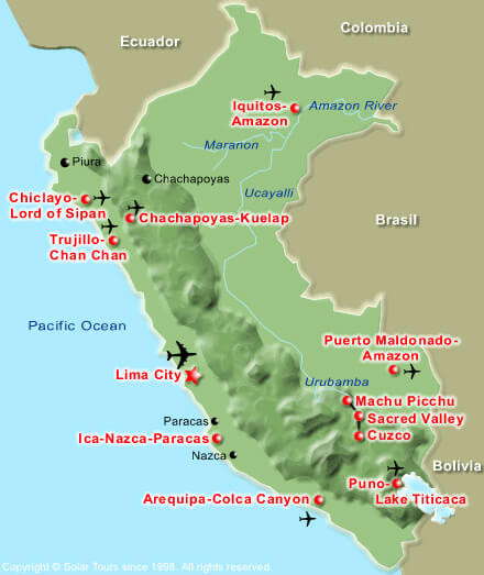
Map of Peru showing the location of the Sacred Valley.