
Argentina's Natural Landscape: Andes, Pampas, Chaco, and Patagonia
Argentina spans 2,780,400 km², from subtropical wetlands and the Chaco to the Patagonian steppe and glaciers, with Aconcagua at about 6,960 m on its western frontier. The Andes, Pampas, Cuyo's oases, and the Southern Patagonian Ice Field shape its climate and ecoregions, while deforestation, wildfire, and lithium mining pressure its protected areas.


The Natural Landscape of Argentina: From the High Andes to the Pampas and the Ice of Patagonia
Argentina covers 2,780,400 square kilometers (1,073,500 square miles) in the Southern Cone of South America, making it the second-largest country on the continent after Brazil and the eighth-largest in the world. It stretches from the subtropical forests and wetlands of the north to the sub-Antarctic islands of the far south, and from the snow-capped crest of the Andes in the west to the Atlantic coast in the east. Within those limits lie the highest mountain in the Americas, vast humid plains, a dry steppe that fills much of the south, salt flats, great rivers, and the Argentine side of the Southern Patagonian Ice Field. Its variety is the subject of a companion overview, The Geography of Argentina.
Setting and Extent
Argentina borders Chile along the Andes for 6,691 kilometers (4,157 miles) and shares frontiers with Paraguay (2,531 kilometers, or 1,572 miles), Brazil (1,263 kilometers, or 785 miles), Bolivia (942 kilometers, or 585 miles), and Uruguay (541 kilometers, or 336 miles). Land borders total 11,968 kilometers (7,437 miles), and the Atlantic coastline runs for about 4,989 kilometers (3,100 miles). The exclusive economic zone adds 1,159,063 square kilometers (447,517 square miles) of ocean, much of it over the broad continental shelf of the Argentine Sea.
The highest point is Aconcagua, about 6,960 meters (22,835 feet), the summit of the Americas, and the lowest is Laguna del Carbón, 105 meters (344 feet) below sea level, in Santa Cruz Province. Official sources give slightly different heights for Aconcagua, from 6,959 to 6,962 meters, and a different total area for the country depending on whether the claimed Antarctic sector and the South Atlantic islands are counted. Argentina asserts sovereignty over a sector of Antarctica that overlaps the claims of Chile and the United Kingdom and is frozen under the Antarctic Treaty of 1959, and it disputes British administration of the Falkland Islands, which Argentina calls the Malvinas.
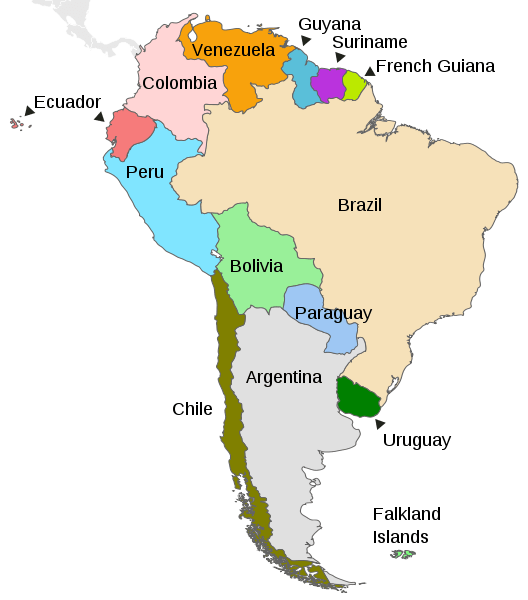
Map depicting the countries of South America.
Geology: A Continent Built from the West
The shape of Argentina is a result of plate tectonics. Beneath the Pacific, the Nazca Plate slides under the South American Plate, and Argentina sits on the upper plate. This convergence has pushed up the Andes, driven volcanism, and produced earthquakes in the western provinces. East of the mountains, ancient crystalline blocks form the old rock of the Sierras Pampeanas, Patagonian tablelands lie across the south, and wide sedimentary basins fill the center and the northeast. Rivers and winds have covered the Pampas with deep loess and silt, the foundation of the country's famous farmland.
The Andes and the Western Ranges
The Andes run the full length of the western frontier and shape every climate and river in the country. In the north and center, the range is broad, dry, and very high. Aconcagua, in Mendoza Province, towers above a cluster of peaks over 6,000 meters (19,685 feet), and farther north the border with Chile is marked by volcanoes such as Ojos del Salado, 6,893 meters (22,615 feet), the highest volcano on Earth, and Monte Pissis, about 6,795 meters (22,293 feet), which lies wholly within Argentina. South of about 40 degrees south latitude, the Andes drop sharply, and in the Patagonian and Fuegian Andes the crest is lower but heavily glaciated and often sheathed in cloud. Cerro Tronador, on the border near Bariloche, is a glaciated giant of this southern range. A fuller catalog of peaks appears in Argentina's Alpine World.
East of the main chain, a second belt of older, lower ranges rises from the plains. The Sierras Pampeanas of Córdoba, San Luis, La Rioja, Catamarca, and Tucumán are tilted blocks of ancient rock, which include the granite ridges of the Sierra de Córdoba. They catch moisture on their eastern slopes and sit like islands above surrounding dry lowlands.
Volcanoes and Earthquakes
The Argentine Andes include some of the world's highest volcanoes, though most are dormant or extinct, and few have erupted in the historical record. The volcanic belt in the northwest is part of the Altiplano–Puna Volcanic Complex, one of the planet's great volcanic fields. Farther south, volcanoes such as Lanín and Copahue rise along the Chilean border, and ash from Chilean eruptions has repeatedly fallen on Patagonian towns. Earthquakes are the more frequent hazard, and they are concentrated in the Andean provinces of the west and northwest.
Climate: Rain Shadow, Cold Fronts, and Warm Winds
Argentina's climate is as varied as its relief, and the Andes are the main controlling feature. From about 40 degrees south, the range is high enough to block most moist Pacific air, which creates the dry belt that crosses the country from the northwest through Cuyo to Patagonia, the same swath of dryland described in The Arid Diagonal. Ocean currents play a smaller part. The cold Humboldt Current, off the Pacific coast of Chile and Peru, helps sustain the aridity of the Atacama and the Puna on the range's western side, while the cold Malvinas Current flows north along the Atlantic coast of Patagonia and cools its shoreline. Rainfall is heaviest in the northeast, where the humid subtropical climate of Misiones and Corrientes has no dry season, and rain can approach 2,000 millimeters (79 inches) a year, and no part of the country receives much more than that. The driest places, in San Juan, La Rioja, Catamarca, and parts of Salta, average only about 100 millimeters (4 inches), and Mendoza, in the lee of the Andes, receives roughly 225 millimeters (9 inches). As a result, its vineyards and orchards depend on irrigation from Andean rivers.
Several winds give the country's weather its character. The Pampero is a cold, dry wind that blows from the south across the Pampas and Patagonia after a cold front passes. The zonda is a hot, dry wind that descends the eastern slopes of the Andes in San Juan and Mendoza, mostly in winter and spring, and can raise temperatures sharply within hours. Cold fronts that move north from Patagonia in July can bring frost and snow to the Pampas and Mesopotamia, and in rare years a dusting falls on Buenos Aires. In the north, the Chaco is the hottest part of the country, with 500 to 1,000 millimeters (20 to 40 inches) of rain falling mostly in summer, followed by a pronounced dry winter. High elevations at every latitude are colder, and above about 3,500 meters (11,500 feet) in the north, the climate becomes tundra-like.

Topographical map of Argentina.
Rivers, Lakes, and Wetlands
Most of Argentina drains toward the Atlantic through the Río de la Plata system. The Paraná River, roughly 4,700 kilometers (2,920 miles) long, is the country's longest river, and with the Paraguay and Uruguay rivers, it empties into the wide estuary of the Río de la Plata. The Uruguay River forms the boundary between Entre Ríos and Corrientes and Uruguay, flows past Moconá Falls, and the Paraguay River marks part of the border with Paraguay. Rivers of the Chaco, such as the Bermejo and Pilcomayo, carry sediment from the Andes across the plains and shift course in their flat, braided channels. Beneath the northeast lies the Guaraní Aquifer, one of the world's largest groundwater reservoirs and shared with Brazil, Paraguay, and Uruguay.
Patagonian rivers behave differently. The Río Negro, the Colorado, and the Chubut rise in the Andes and cross the dry steppe to the Atlantic, creating narrow green oases through otherwise arid land. In the southern Andes, glacial lakes fill the valleys. Lago Argentino receives meltwater from the Southern Patagonian Ice Field, and Lake Buenos Aires, which Argentina shares with Chile as Lago General Carrera, has a total area of about 1,850 square kilometers (714 square miles) and is the largest lake in the country by that measure. A broader survey of lakes, rivers, and coastal waters is available in Argentina's Water Bodies.
Glaciers and Ice
Argentina's ice is concentrated in the Andes. In the central Andes, small glaciers and seasonal snow feed the rivers that irrigate Mendoza, San Juan, and neighboring provinces. In the south, the Southern Patagonian Ice Field, which covers about 16,800 square kilometers (6,500 square miles) and is shared with Chile, is among the largest ice masses in the Southern Hemisphere outside Antarctica, and its Argentine outlet glaciers calve into lakes in Los Glaciares National Park. Upsala (about 765 square kilometers, or 295 square miles) and Viedma (about 978 square kilometers, or 378 square miles) are among the largest. The Perito Moreno Glacier, at about 250 square kilometers (97 square miles) and 30 kilometers (19 miles) long, is the most visited, with a front that reaches across a channel of Lago Argentino. Satellite records show that the Patagonian ice fields have thinned significantly over the past four decades, a trend that affects the lakes, rivers, and tourism built around them.
Natural Regions
Geographers divide the country in different ways, but most recognize about eight natural regions that run roughly from west to east and north to south. In the west, the Andes form a continuous region from Jujuy to Tierra del Fuego, with the high, cold Puna in the northwest, where salt flats, flamingo lagoons, and sparse grass lie above 3,500 meters (11,500 feet). South of the Puna, the Andean foothills and the Sierras Pampeanas form the dry western interior, and below them lies Cuyo, the Andean piedmont that includes Mendoza, San Juan, and San Luis. Cuyo is a desert crossed by rivers fed by snow, and its irrigated oases support the country's major wine industry.
The northern lowlands are dominated by the Gran Chaco, a vast plain of thorn forest, savanna, and wetlands shared with Paraguay, Bolivia, and Brazil. Its drier western half and wetter eastern half form different ecoregions, and the area also holds large national parks, such as El Impenetrable and Río Pilcomayo. East of the Chaco, between the Paraná and Uruguay rivers, Mesopotamia combines warm, rainy forests in Misiones with the enormous marshes of the Iberá Wetlands in Corrientes, and it contains the border cascades of Iguazú Falls, where the largest drops reach about 80 meters (262 feet). The mist-shrouded cloud forests of the northwest slopes are the Yungas.
At the center of the country, the Pampas are a nearly flat plain of fertile soil that stretches from the Atlantic to the Sierras, wetter in the east and drier toward the west. South of the Pampas lies Patagonia, a region of cold, windy plateaus and steppe that covers around a quarter to a third of the country, depending on how its northern limit is drawn, and holds only a small share of the population. Its landscapes are described at length in Argentine Patagonia. Beyond the Strait of Magellan, the Argentine part of Tierra del Fuego is a region of its own, with southern beech forests, peat bogs, and glaciated mountains.
Ecoregions and Vegetation
Argentina's major ecoregions follow its natural regions. In the northwest, the Central Andean Puna and Dry Puna are high, cold grasslands and shrublands, the Southern Andean Yungas form montane forest on the wet slopes, and the High Monte and Argentine Monte cover the arid valleys and basins to the south. In the Chaco, the Dry Chaco is dominated by thorn forest and the Humid Chaco by palm savannas and marshes. The Southern Cone Mesopotamian savanna and the Paraná flooded savanna cover the Mesopotamian floodplains, and in Misiones the Upper Paraná Atlantic forests and Araucaria moist forests reach their southern limits.
The central plains hold the Humid Pampas, the Semi-arid Pampas, and the Argentine Espinal, an arc of low open woodland that wraps around them. In the south, the Patagonian steppe and Patagonian grasslands spread across the dry plateaus, and the Southern Andean steppe clothes the high eastern slopes. On the wetter Andean flank, the Andean Patagonian forest and the Valdivian temperate forests form dense temperate woodland that continues to the Magellanic subpolar forests at the continent's tip.
Biodiversity and Wildlife
Argentina's range of habitats supports an equally wide variety of life. In the northern forests and wetlands live the jaguar (Panthera onca), an animal now rare in the country and the focus of reintroduction efforts in Iberá, along with caimans, giant anteaters, and howler monkeys. The Pampas are home to the greater rhea (Rhea americana), and the Andes and Patagonian steppe shelter the guanaco (Lama guanicoe), the vicuña (Vicugna vicugna) in the high northwest, the puma (Puma concolor), and the Andean condor (Vultur gryphus). Among the rarest large mammals is the huemul (Hippocamelus bisulcus), an Andean deer of the southern forests. The coast of Península Valdés is one of the world's best places to see southern right whales (Eubalaena australis), and its beaches shelter sea lions, elephant seals, and Magellanic penguins (Spheniscus magellanicus). Characteristic plants include the quebracho trees of the Chaco, the cardón cacti of the northwestern valleys, and the southern beeches of Patagonia, including lenga (Nothofagus pumilio) and ñire (Nothofagus antarctica).
Islands and the Argentine Sea
Argentina's islands are mostly riverine or sub-Antarctic. In the north, thousands of islands fill the Paraná delta, an area protected in part by the Delta del Paraná Biosphere Reserve. In the far south, the Argentine half of Tierra del Fuego extends to the Beagle Channel, which connects the Atlantic and Pacific and, together with the Strait of Magellan, is one of the continent's historic sea routes. Isla de los Estados, the South Atlantic islands, and the disputed Falkland Islands lie offshore, and a fuller account of all of them is in Argentina's Islands and Archipelagos.
Protected Areas and Conservation
Argentina has hundreds of protected areas, including national parks, provincial reserves, and biosphere reserves, yet estimates of how much land they cover differ. The national system, SiFAP, reported 16.61 percent of the continental area and 7.11 percent of the marine area under protection as of December 2024, while the global database Protected Planet counts about 245,000 square kilometers (94,600 square miles) of land, or roughly 9 percent, and 12 percent of marine waters. Five of Argentina's 12 UNESCO World Heritage Sites are natural: Los Glaciares National Park (1981), Iguazú National Park (1984), Península Valdés (1999), Ischigualasto and Talampaya Natural Parks (2000), and Los Alerces National Park (2017). The Ischigualasto and Talampaya parks preserve a nearly complete sequence of Triassic rocks and fossils, and Los Alerces protects stands of the long-lived alerce (Fitzroya cupressoides).
Marine protection grew sharply in 2018, when Argentina created the Yaganes and Namuncurá–Burdwood Bank II marine parks, which together cover about 98,000 square kilometers (37,800 square miles) of the South Atlantic. Other highlights include the northwestern high Andean reserves such as Los Cardones, the Patagonian lake parks of Nahuel Huapi, Lanín, and Lago Puelo, the coastal Monte León, the rewilded steppe of Parque Patagonia, and the southernmost Tierra del Fuego National Park. In the high northwest, Laguna de los Pozuelos protects flamingo lagoons. In the center, Quebrada del Condorito preserves a high grassland canyon that serves as a refuge for the Andean condor, and Lihué Calel protects a low mountain range in the dry Pampa of La Pampa Province.
Pressures on the Landscape
Argentina's greatest conservation pressure is the conversion of native land to farmland. The Gran Chaco has one of the world's highest deforestation rates, driven mostly by soy and cattle expansion. A national Forest Law passed in 2007 slowed the loss. Still, the Inter-American Development Bank estimates that about 3.7 million hectares (37,000 square kilometers, or 14,300 square miles) of forest were still lost between 2007 and 2022. Greenpeace reported that Argentina lost 149,649 hectares (1,496 square kilometers, or 578 square miles) of Chaco forest in 2024 alone, mostly to agriculture and fire. Wildfire is a second threat: official fire-service data show that fires affected about 1.8 million hectares (18,000 square kilometers, or 6,950 square miles) across the country in 2022. The Pampas themselves have become one of the most intensively farmed landscapes on Earth, and only fragments of the original grassland survive.
Extractive industries leave their own mark. Lithium is pumped as brine from the salt flats of the northwest, as at the Salar del Hombre Muerto and Salinas Grandes, where Indigenous communities and mining companies compete for scarce water. In Neuquén Province, the Vaca Muerta shale formation, which covers about 34,800 square kilometers (13,400 square miles), has made Argentina a major oil and gas producer, bringing new roads and wells to northern Patagonia. Glacier retreat, drought in the central Andes, and the growing number of visitors to places such as Los Glaciares and Iguazú put pressure on the water supplies and parks Argentina has worked to protect.
Landscape and People
The distribution of Argentine settlement follows its geography. The 2022 census counted 46,044,703 people, and about one in three live in the Buenos Aires metropolitan area on the humid plains beside the Río de la Plata, while the Chaco, the Puna, and Patagonia remain thinly populated. The country's wealth has long come from the Pampas, its wine from the irrigated oases of Cuyo, its energy from Patagonia and the northwest, and its identity from the open spaces of the plains and the mountains beyond them. How those landscapes shaped the nation's peoples, cities, and traditions is the subject of Argentina's cultural landscape.

Argentina physiographic map.