The Greater Antilles: Crossroads of Caribbean History, Culture, and Nature
The Greater Antilles, an enchanting region in the Caribbean, comprises the islands of Cuba, Hispaniola (shared by Haiti and the Dominican Republic), Puerto Rico, Jamaica, and the Cayman Islands. Together, these islands make up nearly 90% of the landmass of the entire West Indies.

")

")
 aerial view from an Army UH-60 Blackhawk during operation Unified Response - via Wikimedia Commons")

The Greater Antilles: A Cultural and Natural Mosaic of the Caribbean
The Greater Antilles form the dominant landmass of the Caribbean, comprising the islands of Cuba, Hispaniola (shared by Haiti and the Dominican Republic), Puerto Rico, Jamaica, and the Cayman Islands. Together, these islands account for nearly 90% of the total land area of the West Indies, making them the geographic heart of the region and home to its most diverse array of cultures, ecosystems, and historical legacies.
Geography and Geological Origins
The Greater Antilles occupy the northern arc of the Caribbean archipelago, positioned along the boundary between the North American Plate and the Caribbean Plate. This tectonic setting has given the islands their characteristic ruggedness. Cuba's Sierra Maestra rises to 1,974 m (6,476 ft) at Pico Turquino, while Hispaniola's Cordillera Central reaches its apex at Pico Duarte, the highest peak in the Caribbean at 3,098 m (10,164 ft). Jamaica's Blue Mountains top out at 2,256 m (7,402 ft) at Blue Mountain Peak, and Puerto Rico's Cordillera Central reaches 1,338 m (4,390 ft) at Cerro de Punta. The Cayman Islands, by contrast, are low-lying limestone formations rising only a few metres above sea level, perched atop the Cayman Ridge between two deep ocean trenches.
The islands' geological complexity is reflected in their varied landscapes — from Cuba's broad plains and rolling mogotes (limestone hillocks) of the Viñales Valley, to Hispaniola's dramatic mountain ranges and Haitian plateaus, to the karst formations and coastal mangroves found throughout the region. The Cayman Trench, which runs southwest of Jamaica, is one of the deepest points in the Caribbean Sea, reaching approximately 7,686 m (25,217 ft).

Greater Antilles relief location map.
Cuba: Heart of the Caribbean
Cuba is the largest island in the Caribbean, spanning approximately 109,884 sq km (42,426 sq mi). Its cultural identity is among the most distinctive in the Americas, shaped by layers of Taíno heritage, Spanish colonial rule, African traditions brought through the centuries of the slave trade, and a 20th-century revolution that profoundly altered the island's social and political fabric. Havana, its capital, is renowned for its baroque and neoclassical architecture, much of it frozen in the mid-20th century, and for a musical culture that gave the world son, salsa, and the Buena Vista Social Club sound.
Ecologically, Cuba is extraordinary. The island supports more than 6,700 species of flowering plants, of which roughly half are endemic. Its coral reef systems, particularly the Jardines de la Reina archipelago off the south coast, are among the least disturbed in the Caribbean, sheltering an abundance of reef sharks, tarpon, and the critically endangered hawksbill sea turtle (Eretmochelys imbricata). The Sierra Maestra range in the southeast contains Turquino National Park, a UNESCO Biosphere Reserve, where cloud forest gives way to pine woodland and rare ferns at higher elevations.
Hispaniola: A Land of Contrasts
Hispaniola is the second-largest island in the Caribbean at 76,192 sq km (29,418 sq mi), shared between Haiti in the west and the Dominican Republic in the east. The division of the island between two nations with vastly different developmental trajectories makes Hispaniola one of the most geographically and socially fascinating places in the Western Hemisphere.
Haiti occupies 27,750 sq km (10,714 sq mi) of the island's western third. Despite severe environmental degradation — deforestation has reduced forest cover to less than 2% in some estimates — Haiti retains areas of remarkable biological significance, including the Massif de la Selle and the pine forests bordering the Dominican Republic. Culturally, Haiti is defined by its singular history as the world's first Black republic, born of the Haitian Revolution of 1791–1804. The Citadelle Laferrière, a massive mountaintop fortress built following independence, is one of the most dramatic architectural achievements in the Americas and forms part of the UNESCO-listed National History Park.
The Dominican Republic, covering the remaining 48,442 sq km (18,704 sq mi), presents a sharply different landscape. Los Haitises National Park protects a karst region of limestone haystack hills covered in primary rainforest and riddled with caves bearing Taíno petroglyphs. The country's coastline ranges from the mangrove-fringed lagoons of Jaragua National Park in the southwest to the Atlantic-facing beaches of the Samaná Peninsula. Santo Domingo, the nation's capital, is home to the oldest continuously inhabited European settlement in the Americas, its colonial zone designated a UNESCO World Heritage Site.
Puerto Rico: Where Cultures Converge
Puerto Rico covers 9,104 sq km (3,515 sq mi) and, as a US territory, occupies a unique political position in the Caribbean. Its capital, San Juan, is defined by the imposing fortifications of Castillo San Felipe del Morro and Castillo San Cristóbal, built by the Spanish between the 16th and 18th centuries to guard one of the most important ports in the colonial Atlantic world.
The island's ecological crown jewel is El Yunque National Forest in the northeast — the only tropical rainforest in the US National Forest System, covering approximately 11,331 ha (28,000 acres). Its forests receive up to 5,000 mm (200 in) of rain annually and shelter the critically endangered Puerto Rican amazon (Amazona vittata), one of the rarest birds in the world, along with hundreds of endemic plant species and the tiny coquí frog (Eleutherodactylus coqui), whose evening song has become a cultural symbol of the island. Puerto Rico's bioluminescent bays — Mosquito Bay on Vieques, Laguna Grande in Fajardo, and La Parguera — rank among the brightest in the world.
Jamaica: Culture and Landscape Intertwined
Jamaica, at 10,990 sq km (4,244 sq mi), punches far above its size in cultural terms. As the birthplace of reggae, ska, and dancehall, and the homeland of Bob Marley, Jamaica has shaped global popular culture to a degree disproportionate to its population. The rhythms, language, and cuisine of Jamaica — jerk seasoning, ackee and saltfish (the national dish), and the distinctive patois spoken across the island — have spread throughout the Caribbean diaspora worldwide.
Inland, the Blue and John Crow Mountains rise steeply from both coasts and harbor an extraordinary degree of biodiversity. This range is listed as a UNESCO World Heritage Site, recognised for both its natural values and its cultural significance as a refuge for maroon communities — descendants of escaped enslaved people who maintained autonomous societies in the mountain forests. The endemic Jamaican tody (Todus todus), the streamertail hummingbird (Trochilus polytmus, the national bird), and more than 800 endemic plant species are found here. Jamaica's coffee, grown in the high Blue Mountains, is among the most prized in the world.
The Cayman Islands: Coral, Finance, and Marine Life
The three Cayman Islands — Grand Cayman, Cayman Brac, and Little Cayman — together cover just 264 sq km (102 sq mi), yet they are globally significant as both a financial centre and a marine conservation destination. The islands' shallow, crystalline waters support exceptional coral reef systems, and their government has established several marine protected areas, allowing reef ecosystems to recover substantially in recent decades.
Grand Cayman's Stingray City, a series of shallow sandbanks in the North Sound, has become one of the most visited underwater attractions in the Caribbean, where southern stingrays (Hypanus americanus) congregate in remarkable numbers. Little Cayman hosts the largest breeding colony of red-footed boobies (Sula sula) in the Western Hemisphere at the Booby Pond Nature Reserve, with an estimated 5,000 nesting pairs. The critically endangered Cayman blue iguana (Cyclura lewisi), found only on Grand Cayman, is the subject of an intensive captive breeding and release programme that has brought the species back from near-extinction.
Shared Ecology: Flora and Fauna of the Greater Antilles
The Greater Antilles constitute one of the world's most important biodiversity hotspots. Their long geological isolation has led to extraordinary levels of endemism across all taxonomic groups. Amphibians, in particular, show staggering diversity and endemism — Cuba alone harbours more than 60 species of frogs in the genus Eleutherodactylus, most of which are found nowhere else on earth. The West Indian manatee (Trichechus manatus) ranges across the coastal waters of all the major islands, while the American crocodile (Crocodylus acutus) inhabits river mouths and coastal lagoons throughout the region.
Marine ecosystems are equally rich. The coral reefs of the Greater Antilles are part of the Mesoamerican Reef system, the second-largest barrier reef in the world, and support thousands of species of fish, invertebrates, and algae. The region's seagrass beds serve as critical feeding grounds for sea turtles and manatees, while mangrove forests along every coastline provide nursery habitat for commercially important fish species.
History: Layered Civilizations
Long before European arrival, the Greater Antilles were home to Taíno and Arawak peoples who had settled the islands over several millennia, developing complex chiefdom societies with sophisticated agricultural systems, ball courts, and a rich material culture. Petroglyphs and zemis (carved spiritual objects) testify to their presence throughout the region. Christopher Columbus reached the Bahamas in 1492 and explored Cuba and Hispaniola on his first voyage, setting in motion a colonial process that would transform the islands utterly within a generation.
Spanish, and later British and French, colonial powers established plantation economies dependent on the forced labour of millions of enslaved Africans, whose descendants now form the majority of the population across most of the Greater Antilles. The legacy of this history is woven into every aspect of Caribbean culture — in music, religion (including Vodou in Haiti, Santería in Cuba, and Rastafarianism in Jamaica), language, and cuisine. The struggle for independence and sovereignty has marked each island differently: Haiti achieved independence in 1804, Cuba not until 1898 following the Spanish-American War, and Jamaica and Barbados in the 1960s. Puerto Rico remains a US territory, and the Cayman Islands a British Overseas Territory.
Conclusion
The Greater Antilles are irreplaceable — not only as a region of exceptional natural beauty and biodiversity, but as a living record of some of the most consequential episodes in Atlantic history. From the revolutionary legacy of Haiti to the ecological wonders of El Yunque, from the jazz-inflected streets of Havana to the coral gardens of the Cayman Islands, these islands reward close attention and careful stewardship. Preserving their natural and cultural heritage is not merely a regional obligation, but a responsibility shared by the wider world.
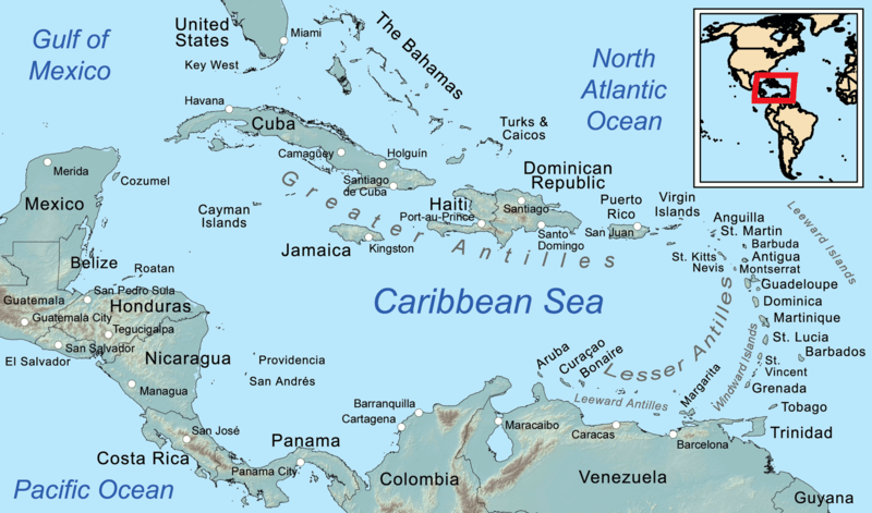
Map depicting the Greater Antilles within the larger Caribbean region.