The Amazon River System: Nature's Mightiest Waterway
The Amazon River system is a vast and complex network of waterways that forms the lifeblood of South America. This immense river system plays a crucial role in shaping South America's ecology, climate, and human geography and significantly impacts global climate patterns.

The River of Rivers: Understanding the Amazon's Aquatic Highway
The Amazon River system stands as Earth's most powerful aquatic network, channeling the flow from over 1,100 tributaries across 6.3 million square kilometers (2.4 million square miles) into a single mighty river that delivers 209,000 cubic meters (7.4 million cubic feet) of water per second to the Atlantic Ocean. This colossal flow represents 15-20% of all freshwater entering the world's oceans, making the Amazon not just South America's arterial system, but a critical component of global ocean circulation and climate regulation.
Serving as the liquid lifeline of Amazônia, the river system functions as both a highway for life and a massive engine of global weather patterns, transporting nutrients across a continent while generating atmospheric moisture that influences precipitation from Argentina to North America. From its humble beginnings in Peruvian mountain springs to its vast Atlantic mouth, this liquid giant demonstrates the power of water to shape landscapes, sustain ecosystems, and connect diverse environments across thousands of kilometers.
The River's Journey: From Andes to Atlantic
Headwater Origins
The Amazon River's journey begins at 5,170 meters (16,960 feet) elevation in Peru's Cordillera Rumi Cruz, where the Apurímac River springs from glacial melt and mountain precipitation. This small stream, initially narrow enough to leap across, represents the start of the world's most voluminous river system.
Source Determination: The river's true source remained disputed until 2001, when Geographic expeditions confirmed the Apurímac-Ucayali system as the Amazon's longest tributary, extending the river's total length to 6,400 kilometers (4,000 miles).
Andean Confluence: As the river descends through Peru's eastern Andes, it gains volume from countless mountain streams, transforming from a turbulent mountain river into the broader Ucayali River by the time it reaches the Amazon lowlands.
The Great Convergence
The Amazon River proper begins at the confluence of the Ucayali and Marañón rivers near Iquitos, Peru. From this point, the river flows eastward across relatively flat terrain with an average gradient of just 2 centimeters per kilometer (1.3 inches per mile).
Channel Characteristics: The river's width varies dramatically along its course, from 1.6 kilometers (1 mile) at Iquitos to over 10 kilometers (6.2 miles) during flood season at its mouth. During peak floods, the river can expand to 48 kilometers (30 miles) wide in some locations.
Flow Velocity: Despite its massive volume, the Amazon flows relatively slowly, averaging 2-5 kilometers per hour (1.2-3.1 mph). This slow flow allows sediments to settle and creates the meandering pattern characteristic of lowland rivers.
The Atlantic Discharge
At its mouth, the Amazon creates a massive freshwater plume extending 400 kilometers (250 miles) into the Atlantic Ocean. This discharge is so powerful that fresh water can be detected 160 kilometers (100 miles) offshore, and the river's sediment plume is visible from space.
Tributary Network: Rivers as Mighty as the Amazon
The Major Tributaries
The Amazon's tributary system includes 17 rivers over 1,500 kilometers (930 miles) long, each substantial enough to rank among the world's major rivers:
Madeira River (3,250 km/2,020 miles): The Amazon's longest tributary, draining Bolivia's highlands and carrying the second-largest sediment load globally.
Purús River (3,210 km/1,995 miles): Meandering extensively through Peru and Brazil, this river drains lowland areas and shows extreme seasonal variation.
Japurá River (2,820 km/1,750 miles): Originating in Colombia as the Caquetá River, it demonstrates the system's international character.
Negro River (2,250 km/1,400 miles): The largest blackwater tributary, meeting the Amazon's muddy waters in a dramatic "Meeting of Waters" at Manaus that extends for several kilometers downstream.
Tributary Classifications by Water Type
Whitewater Tributaries: Rivers like the Madeira, Ucayali, and the main Amazon carry high sediment loads from Andean erosion. These rivers support productive várzea floodplains and the majority of the basin's human population.
Blackwater Tributaries: The Negro, Tapajós, and other rivers draining ancient shield areas carry dissolved organic compounds that stain the water dark brown or black. These acidic rivers (pH 4.5-6.5) support specialized fish communities.
Clearwater Tributaries: Rivers like the Xingu and Tocantins from the Brazilian Shield carry little sediment and have intermediate chemical properties, often supporting high fish endemism.
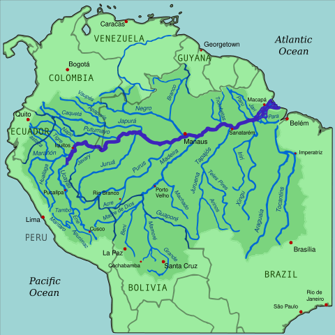
Map depicting the Amazon River drainage basin with the Amazon River and its tributaries highlighted.
Hydrological Dynamics and Seasonal Rhythms
The Flood Pulse: Annual Rhythms of Life
The Amazon River system operates on a massive annual flood cycle that drives ecological and human activities throughout the basin:
Flood Timing: Different regions experience peak floods at different times. Northern tributaries (Negro, Solimões) peak during May-July, while southern tributaries (Madeira, Tapajós) peak during February-April. This timing differential moderates extreme floods in the main stem.
Water Level Fluctuations: The river rises 10-15 meters (33-49 feet) annually in many locations. At Manaus, the difference between high and low water approaches 20 meters (66 feet), exposing or inundating vast areas of floodplain.
Ecological Triggers: These water level changes trigger spawning in fish, fruit production in floodplain trees, and migration patterns in both aquatic and terrestrial animals.
Sediment Transport and Deposition
The Amazon River system transports approximately 1.3 billion tons of sediment annually, primarily from Andean erosion:
Sediment Sources: The western 12% of the basin (Andean region) contributes over 90% of the river's sediment load.
Deposition Patterns: Most sediment deposits in várzea floodplains during annual floods, creating some of the world's most fertile agricultural soils.
Coastal Impact: Sediments reaching the Atlantic Ocean influence coastal geomorphology across northern South America, contributing to mudbank migration along the Guiana coast.
Groundwater Connections
Recent discoveries reveal the Amazon's complex relationships with groundwater:
The Hamza River: Scientists have identified a massive underground river system flowing 4,000 meters (13,100 feet) beneath the Amazon, potentially carrying similar water volumes to the surface river.
Hyporheic Exchange: Constant exchange between surface and groundwater creates unique ecological zones supporting specialized microbial and invertebrate communities.
Storage Capacity: Groundwater reserves beneath the Amazon Basin may exceed 100 times the river's annual flow, representing a critical water resource for future climate scenarios.
Aquatic Biodiversity: A Freshwater Ocean
Fish Diversity and Endemism
The Amazon River system supports the world's richest freshwater fish fauna, with over 3,000 described species and estimates of 5,000+ total species:
Size Range: Species range from tiny tetras weighing less than 1 gram to giant catfish (Brachyplatystoma spp.) exceeding 100 kilograms (220 pounds) and 2 meters (6.6 feet) in length.
Ecological Roles: Fish fill every conceivable environmental niche, including fruit-eaters (Colossoma spp.), wood-borers (Panaque spp.), scale-eaters (Catoprion spp.), and even vampire fish (Vandellia spp.) that parasitize other fish.
Reproductive Strategies: Many large fish species undertake migrations of thousands of kilometers for spawning, while others practice sophisticated parental care, including mouthbrooding and nest-guarding.
Aquatic Mammals and Reptiles
The river system supports unique vertebrate communities adapted to aquatic life:
Amazon River Dolphin (Inia geoffrensis): The largest river dolphin species, using echolocation to navigate murky waters and reaching lengths of 2.5 meters (8.2 feet).
West Indian Manatee (Trichechus manatus): These gentle giants feed on aquatic vegetation in quiet backwaters and river mouths.
Black Caiman (Melanosuchus niger): The Amazon's largest predator, reaching 6 meters (20 feet) in length and serving as a keystone species in aquatic ecosystems.
Giant River Otter (Pteronura brasiliensis): Highly social otters forming family groups that hunt cooperatively for fish.
Invertebrate Communities
The river system's invertebrate diversity remains largely unknown but includes remarkable adaptations:
Filter Feeders: Massive populations of clams and mussels filter organic matter from the water column.
Parasitic Specialists: Complex parasite communities comprise species with multi-host life cycles that span both aquatic and terrestrial environments.
Seasonal Specialists: Many invertebrates synchronize reproduction with flood cycles, producing mass emergences that feed countless birds and fish.
Human Interactions: Rivers as Highways
Indigenous River Cultures
For millennia, Indigenous peoples have developed sophisticated relationships with the river system:
Navigation Knowledge: Traditional navigators read subtle water signs—current patterns, debris lines, and surface disturbances—to navigate safely through complex channel systems.
Seasonal Calendars: Indigenous communities maintain detailed ecological calendars that track fish runs, fruit seasons, and flood timing, which are essential for effective resource management.
Flood Adaptation: Architecture, agriculture, and social organization reflect adaptations to annual flood cycles, with many communities maintaining both high-water and low-water settlements.
Contemporary River Transportation
The Amazon River system serves as South America's longest navigable waterway:
Commercial Shipping: Ocean-going vessels up to 40,000 tons can reach Manaus year-round, while smaller vessels access tributaries throughout the basin.
Passenger Transport: Regional boats called "recreios" carry passengers between river communities, serving as buses, trucks, and social centers for riverside populations.
Cargo Movement: Rivers transport everything from petroleum products and manufactured goods downstream to agricultural products and raw materials upstream.
Urban River Centers
Major cities have developed at strategic river locations:
Manaus, Brazil: Located at the Negro-Amazon confluence, this metropolitan area of 2.2 million people serves as the region's economic hub, accessible to ocean shipping despite being 1,500 kilometers (930 miles) inland.
Iquitos, Peru: The world's largest city inaccessible by road, entirely dependent on river and air transport, with 400,000 inhabitants.
Belém, Brazil: The river's principal port, handling over 13 million tons of cargo annually and serving as the gateway between the Amazon and the Atlantic.
Economic Significance and Resource Extraction
Fisheries and Aquaculture
The river system supports both subsistence and commercial fisheries:
Subsistence Fishing: Provides protein for millions of riverside residents, with per capita fish consumption exceeding 50 kilograms (110 pounds) annually in many areas.
Commercial Species: High-value species like pirarucu (Arapaima gigas), tambaqui (Colossoma macropomum), and catfish support regional economies.
Aquaculture Development: Fish farming, particularly of native species, offers sustainable protein production while reducing pressure on wild populations.
Hydroelectric Potential and Challenges
The river system's energy potential attracts development interest while raising environmental concerns:
Existing Projects: Over 150 dams operate on Amazon tributaries, generating approximately 40,000 megawatts of electricity.
Proposed Development: Plans for additional dams could generate 70,000+ megawatts but threaten fish migration routes and floodplain connectivity.
Environmental Trade-offs: Hydroelectric development offers clean energy but can fragment river systems, alter flood cycles, and displace human communities.
Navigation Infrastructure
Maintaining navigable channels requires ongoing intervention:
Channel Management: Dredging operations keep shipping channels open, removing sediments that naturally accumulate in river bends.
Port Facilities: Floating ports accommodate extreme water level fluctuations, rising and falling with seasonal cycles.
Signal Systems: Navigation aids help vessels navigate through a river system where channels are constantly shifting.
Environmental Pressures and Changes
Climate Change Impacts
Changing climate patterns increasingly stress the river system:
Precipitation Changes: Models predict more extreme wet and dry seasons, potentially altering the flood pulse that drives ecosystem functioning.
Temperature Increases: Warming water temperatures may exceed thermal tolerance limits for many aquatic species.
Extreme Droughts: Recent severe droughts (2005, 2010, 2015) have exposed vast areas of river bottom and stranded communities normally accessible by boat.
Pollution Threats
Despite its vast size, the river system shows increasing pollution impacts:
Mercury Contamination: Gold mining operations have introduced an estimated 2,000 tons of mercury into river systems, threatening fish and human health.
Urban Pollution: Growing cities discharge untreated sewage and industrial waste directly into rivers.
Agricultural Runoff: Expanding soybean cultivation and cattle ranching increase fertilizer and pesticide inputs to river systems.
Deforestation Effects
Forest loss throughout the basin creates cascading impacts on river systems:
Hydrological Changes: Deforestation alters precipitation patterns and increases surface runoff, potentially changing flood timing and intensity.
Sedimentation: Erosion from cleared areas increases river turbidity and alters aquatic habitat quality.
Species Disruption: Deforestation fragments aquatic habitats and disrupts the terrestrial-aquatic connections that many species depend upon.
Conservation Efforts and Sustainable Management
Protected Area Networks
River conservation requires landscape-scale protection:
Aquatic Protected Areas: Reserves specifically designed to protect critical fish habitats, spawning areas, and migration corridors.
Watershed Protection: Conservation strategies increasingly focus on protecting entire watersheds rather than individual river segments.
Transboundary Cooperation: River conservation necessitates coordination among multiple countries that share tributary systems.
Sustainable Use Initiatives
Balancing conservation with human needs requires innovative approaches:
Community-Based Fisheries Management: Local communities implement fishing quotas, seasonal closures, and gear restrictions to maintain fish populations.
Sustainable Navigation: Developing navigation practices that minimize environmental impact while maintaining transportation access.
Ecotourism Development: River-based tourism provides economic incentives for conservation while raising awareness about aquatic ecosystems.
Research and Monitoring
Understanding river system health requires comprehensive monitoring:
Biodiversity Assessments: Ongoing species inventories continue revealing new fish and invertebrate species.
Water Quality Monitoring: Networks of monitoring stations track pollution levels and ecological health indicators.
Hydrological Studies: Long-term data collection enables scientists to understand natural variation and detect the impacts of climate change.
Future Challenges and Opportunities
Sustainable Development Pathways
The river system's future depends on balancing multiple competing demands:
Integrated Management: Coordinating shipping, fisheries, hydroelectric generation, and conservation requires sophisticated planning approaches.
Climate Adaptation: Management strategies must accommodate changing precipitation patterns and extreme weather events.
Technology Integration: Advanced monitoring systems and predictive models can improve decision-making for river management.
Restoration Potential
Degraded river systems offer opportunities for restoration:
Habitat Restoration: Reconnecting floodplains and removing obsolete dams can restore natural river processes.
Species Recovery: Well-managed fisheries can recover depleted fish populations, as demonstrated by community-based management programs.
Pollution Control: Implementing waste treatment systems and reducing mining impacts can improve water quality throughout the basin.
Conclusion: The River's Global Legacy
The Amazon River system represents far more than a regional waterway—it is a planetary force that influences ocean circulation, climate patterns, and global biodiversity. This mighty network of rivers serves as South America's circulatory system, connecting Andean highlands with Atlantic lowlands and supporting the world's most diverse freshwater ecosystem.
As climate change and human development increasingly challenge this system, understanding its complexity becomes critical for global environmental management. The health of the Amazon River system affects not only the 30+ million people living within its watershed, but also global climate stability and ocean chemistry patterns that influence weather worldwide.
Protecting this magnificent river system requires recognizing it as an integrated network where local actions can have basin-wide consequences. From the glacial streams of Peru to the vast river mouth in Brazil, every component of this system contributes to its remarkable functioning as Earth's mightiest waterway and one of our planet's most essential life-support systems.
The Amazon River system continues to flow as it has for millions of years, but its future depends on humanity's wisdom in managing this irreplaceable resource. As we deepen our understanding of its complexity and global importance, we must commit to ensuring that this liquid lifeline continues to sustain the incredible diversity of life it has nurtured while providing essential services to our interconnected planet.