


The Central American Isthmus: Land Bridge of the Americas
The Central American Isthmus, a land bridge linking North and South America, transformed global systems 3 million years ago through the Great American Biotic Interchange. It hosts 7% of Earth's biodiversity in less than 1% of land and serves as a key gateway for global commerce via the Panama Canal.

, https://www.flickr.com/photos/josiah_townsend/4785522034")

 https://www.flickr.com/photos/eu_echo/9474711966")


Central America: The Land Bridge That Reshaped a Planet
Few strips of land on Earth have done as much work as the Central American Isthmus. Stretching roughly 2,000 kilometers (1,240 miles) from the southern border of Mexico to the Colombian frontier in the east, this narrow corridor of mountains, volcanoes, rainforest, and coastline connects the North and South American continents, separates the Pacific Ocean from the Caribbean Sea, and harbors a concentration of biological diversity that rivals any region on the planet. At its narrowest, near Panama City, the isthmus is barely 80 kilometers (50 miles) wide — a sliver of land so thin that on a clear day from a high ridge, a traveler can sometimes see both oceans at once.
The seven nations that occupy the isthmus — Guatemala, Belize, Honduras, El Salvador, Nicaragua, Costa Rica, and Panama — cover a combined area of approximately 521,000 square kilometers (201,000 square miles), roughly the size of France. Yet within that compact space, the region contains more tree species than all of North America north of Mexico, more bird species than the United States and Canada combined, and a human cultural history stretching back at least 12,000 years. Understanding the Central American Isthmus means grasping how a relatively small geographic feature can exert an outsized influence on global systems — biological, oceanographic, economic, and cultural — across millions of years of Earth history and into the present.
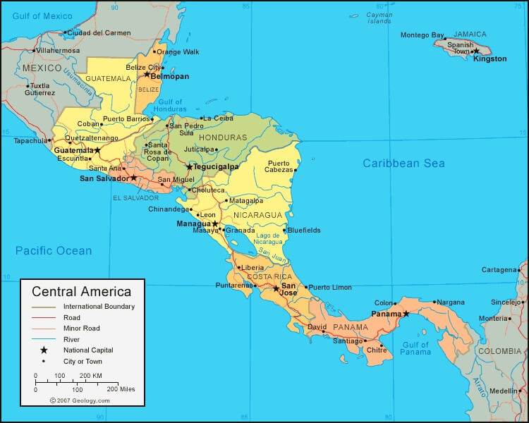
Political map of Central America.
Geological Origins and Tectonic Setting
The Central American Isthmus is geologically young, and its formation ranks among the most consequential events in the history of life on Earth over the past several million years. The isthmus sits at the intersection of three major tectonic plates: the North American plate, the Caribbean plate, and the Cocos plate. It is the ongoing subduction of the Cocos plate beneath the Caribbean plate along the Middle America Trench — a deep-sea feature running parallel to the Pacific coast at depths of up to 6,700 meters (21,980 feet) — that drives the volcanic arc forming the region's mountainous backbone. As the Cocos plate dives into the mantle, it melts and releases magma upward through the overlying crust, feeding the chain of more than 40 volcanoes that lines the Pacific margin from Guatemala to Panama.
The result is a landscape defined by volcanic energy. Guatemala's Volcán Tajumulco, the highest point in Central America at 4,220 meters (13,845 feet), is a dormant stratovolcano whose flanks support cloud forest and Indigenous Maya agricultural communities. The neighboring Volcán Santiaguito has been in near-continuous eruption since 1922, a record of sustained activity rare in the world. In Nicaragua, Masaya volcano maintains one of the few persistent lava lakes on Earth, a churning pool of molten rock that Spanish colonial chroniclers witnessed in the 16th century and called the "Mouth of Hell." Costa Rica's Arenal was considered dormant until a catastrophic eruption in 1968 destroyed several villages and killed at least 87 people; it then remained almost continuously active until 2010 and continues to emit gases. Guatemala's Volcán de Fuego — the "Volcano of Fire" — regularly justifies its name: its June 2018 eruption produced pyroclastic flows that killed more than 190 people and devastated the village of San Miguel Los Lotes, a reminder that the region's geology remains as active as at any point in its history.
The continuous mountain chain running the length of the isthmus reaches its southern apex in the Cordillera de Talamanca of Costa Rica and Panama, where Cerro Chirripó rises to 3,821 meters (12,536 feet). The Talamanca range is notably different from the volcanic ranges to the north. Rather than volcanoes, it is composed primarily of ancient intrusive igneous and metamorphic rocks that were uplifted by tectonic forces. Its high-altitude páramo ecosystems — open grasslands and shrublands above the treeline — are shared with the Andes of South America but found nowhere else in Central America, a biogeographic bridge within the land bridge itself.
The Closing of the Seaway and the Great American Biotic Interchange
Before the isthmus was fully formed, the gap between North and South America allowed open oceanic circulation between the Atlantic and Pacific basins. Marine geologists and paleoclimatologists have determined that this Central American Seaway began closing gradually as volcanic islands and submarine ridges accumulated over tens of millions of years, with the final closure occurring approximately 3.1 to 2.8 million years ago during the Pliocene epoch. The consequences were planetary in scale.
The closure of the seaway redirected warm, salty Atlantic surface water northward into what would become the modern Gulf Stream system, intensifying heat transport toward the North Atlantic and contributing to the cooling of the Northern Hemisphere. Many researchers regard this oceanographic shift as a critical trigger for the cycles of glaciation — the ice ages — that have dominated Earth's climate for the past 2.6 million years. In other words, the formation of a land bridge in Central America may have been a proximate cause of the Pleistocene ice ages that covered much of Europe and North America with continental glaciers and fundamentally shaped the evolution of modern humans in Africa.
Biologically, the land connection enabled what scientists call the Great American Biotic Interchange — one of the most dramatic reshufflings of continental fauna in Earth's history. Prior to the closure, the two American continents had been evolving in isolation for roughly 60 million years, producing entirely distinct wildlife communities. When the land bridge opened, animals moved in both directions. From North America southward came ancestors of modern jaguars (Panthera onca), pumas (Puma concolor), tapirs (Tapirus bairdii), deer, horses, mammoths, and llama ancestors. From South America northward came ground sloths — some as large as modern elephants — giant armadillos, glyptodonts (armored relatives of armadillos the size of a Volkswagen Beetle), terror birds, and the ancestors of the Virginia opossum (Didelphis virginiana), today the only marsupial native to North America. Most of the large South American interchange migrants ultimately went extinct, while North American migrants generally fared better in the south — a pattern paleontologists still debate.
The corridor created by the isthmus continues to function as a biological highway today. Millions of migratory birds — including broad-winged hawks (Buteo platypterus) that concentrate in flocks numbering in the hundreds of thousands over the Veracruz coast and Panamanian ridges each autumn — funnel through this narrow land mass on their journeys between North and South American wintering and breeding grounds. The isthmus does not just connect two continents; it acts as a seasonal valve for the hemisphere's migratory wildlife.
Physical Geography and Landscape Diversity
The topographic complexity of the isthmus is remarkable for its scale. Broad Caribbean coastal lowlands, rarely exceeding 100 meters (330 feet) in elevation, give way within short distances to mountain ranges that top 3,000 meters (9,840 feet), before descending again to drier Pacific coastal plains. This compression of elevation zones creates a landscape that functions, in ecological terms, as dozens of distinct regions layered atop one another.
The Caribbean coast receives some of the highest rainfall totals in the Western Hemisphere. Parts of the Mosquito Coast of Nicaragua and Honduras and the Caribbean slopes of Costa Rica and Panama receive annual precipitation of 4,000 to 7,000 millimeters (157 to 276 inches). The town of Cherrapunji in India is frequently cited as one of the world's wettest places, but several Caribbean-slope stations in Costa Rica and Panama rival or exceed it in wet years. This rainfall sustains lush lowland rainforest that grades, with altitude, into cloud forest — among the most atmospheric environments on Earth, where persistent mist condenses on epiphytic mosses, bromeliads, and orchids, dripping water into the root systems of trees that may be 500 years old.
The Pacific coast tells a very different story. A pronounced dry season lasting four to six months, from November or December through April, creates a markedly seasonal landscape in which broadleaf deciduous and semi-deciduous forests shed their leaves during the dry months, and rivers that flow strongly in the wet season shrink to chains of isolated pools. The Pacific lowlands of Guatemala, El Salvador, Nicaragua, and Costa Rica have historically supported the region's most intensive agriculture: sugar cane, cotton, cattle ranching, and, in more recent decades, African oil palm (Elaeis guineensis) — a crop whose rapid spread has been one of the primary drivers of lowland forest loss along the Pacific drainage.
Between the coasts, the highland basins of Guatemala and El Salvador reach elevations of 1,500 to 2,500 meters (4,900 to 8,200 feet) and enjoy a mild, spring-like climate year-round — the conditions that supported dense pre-Columbian population concentrations and continue to make highland coffee one of the region's most prized agricultural products. Guatemala's Altiplano, ringed by volcanic peaks including Atitlán, Tolimán, and San Pedro rising from the caldera lake of the same name, is home to the largest concentration of Indigenous Maya people in Central America. Lake Atitlán itself, formed by a cataclysmic volcanic eruption approximately 84,000 years ago, sits at 1,562 meters (5,125 feet) above sea level and reaches a maximum depth of 340 meters (1,115 feet) — one of the deepest lakes in Central America and one of the most visually dramatic anywhere.
Biodiversity: A Global Hotspot
Central America's position at the junction of two continental biological realms, combined with its dramatic elevation gradients and the isolation of individual mountain ranges and valleys, has produced a concentration of species diversity that is extraordinary by any global measure. The region contains approximately 8% of the world's known species within less than 1% of the world's land surface. Some 20,000 plant species have been recorded — around 30% of them found nowhere else on Earth — alongside more than 1,100 bird species, roughly 350 reptile species, and over 200 amphibian species.
The cloud forests of the Monteverde region in Costa Rica and the Sierra de las Minas in Guatemala are among the most species-rich terrestrial habitats in the hemisphere. Here, a single hectare of forest may support more epiphytic plant species — orchids, bromeliads, ferns, and mosses attached to the bark and branches of trees — than entire countries in temperate latitudes. The resplendent quetzal (Pharomachrus mocinno), perhaps the most celebrated bird of the Americas, inhabits these cloud forests from southern Mexico to western Panama. Males grow tail coverts that extend up to 65 centimeters (26 inches) beyond the body during breeding season, and they nest exclusively in cavities carved into dead, soft-wooded trees — a dependence on old-growth forest structure that makes them an ideal indicator of forest health.
Large mammals persist across the isthmus in numbers that have been dramatically reduced from pre-Columbian levels but that remain significant relative to most of the tropics. The jaguar (Panthera onca), which requires large territories and contiguous forest, is present but under pressure throughout the region; the Mesoamerican Biological Corridor was designed in part to maintain gene flow between jaguar populations separated by agricultural landscapes. Baird's tapir (Tapirus bairdii), the largest native terrestrial mammal in Central America at up to 300 kilograms (660 pounds), is classified as endangered and survives in meaningful numbers only in the larger protected areas of Belize, Guatemala, Honduras, Costa Rica, and Panama. The white-lipped peccary (Tayassu pecari), which once roamed in herds of hundreds through lowland forests, has been extirpated from much of its former range but survives in the Petén of Guatemala, the Mosquitia of Honduras, and the forests of Panama near the Colombian border.
Marine ecosystems on both coasts are equally significant. The Caribbean coast of Belize, Guatemala, Honduras, and Panama forms part of the Mesoamerican Barrier Reef System, the world's second-largest coral reef at over 1,000 kilometers (620 miles) in length. This system supports hawksbill sea turtles (Eretmochelys imbricata), whale sharks (Rhincodon typus), and West Indian manatees (Trichechus manatus), as well as the livelihoods of tens of thousands of coastal fishing communities. On the Pacific coast, seasonal upwelling of cold, nutrient-rich water supports highly productive fisheries and draws large pelagic species, including the olive ridley sea turtle (Lepidochelys olivacea), which engages in mass nesting events known as arribadas on Pacific beaches — spectacles in which tens of thousands of females come ashore simultaneously within a period of days.
Pre-Columbian Civilizations
Humans have inhabited Central America for at least 12,000 years, and the archaeological record documents the emergence of complex, stratified societies well before the rise of the great Classic Period civilizations most closely associated with the Maya. The Clovis-era and pre-Clovis cultures that spread through the isthmus were hunter-gatherers who followed the megafauna that were, by then, approaching extinction across the Americas. Agricultural societies based on the cultivation of maize (Zea mays), squash (Cucurbita spp.), and beans (Phaseolus vulgaris) — the "Three Sisters" complex that would sustain civilizations across much of the hemisphere — began to develop in the highlands of Mexico and spread southward through Central America over millennia.
The Maya civilization, which developed across the Yucatán Peninsula, the Guatemalan Petén, Belize, and the highlands of Guatemala and Honduras, represents the most architecturally and intellectually sophisticated pre-Columbian culture of the isthmus. At the height of the Classic Period (approximately 250–900 CE), the lowland Maya maintained dozens of city-states, the largest of which — Tikal in the Guatemalan Petén — had an estimated population of 60,000 to 90,000 people and controlled a territory of approximately 3,000 square kilometers (1,160 square miles). Tikal's Temple IV, completed around 741 CE under the ruler Yik'in Chan K'awiil, rises 64 meters (210 feet) above the forest floor — for centuries after its construction, it was the tallest building in the Western Hemisphere.
The Maya achievement in mathematics and astronomy was remarkable. Working independently of Old World mathematicians, Maya scholars developed a positional numeral system that included a symbol for zero — an intellectual leap that most of the ancient world never made — and used it to calculate astronomical cycles of extraordinary precision. Their Long Count calendar, which tracked time across spans of millions of years, allowed them to record historical events and project future ones in ways that no other pre-Columbian civilization attempted. The Maya hieroglyphic writing system, one of only a handful of independently invented scripts in human history, encodes a historical record that, since its decipherment in the late 20th century, has revealed royal genealogies, accounts of warfare, and ritual narratives dating back to the 1st century CE.
Beyond the Maya, the isthmus supported numerous other cultures whose contributions are often overshadowed. The Lenca people of Honduras and El Salvador built sophisticated agricultural societies and resisted Spanish conquest with particular tenacity — their leader Lempira, who organized a confederacy of resistance against the conquistadors before being killed in 1537, is commemorated in the name of Honduras's national currency. In Costa Rica and Panama, the Diquís culture produced spherical stone balls of extraordinary precision, ranging from a few centimeters to over 2 meters (6.5 feet) in diameter and weighing up to 15 metric tons (16.5 short tons); more than 300 of these objects have been found, but their purpose and the techniques used to create them remain incompletely understood. The Diquís stone spheres were inscribed on UNESCO's World Heritage List in 2014. In Panama, the Kuna (Guna) people of the San Blas Archipelago maintained a degree of cultural and political autonomy through both Spanish colonial rule and Panamanian independence that is nearly without parallel in Central America, culminating in the Kuna Revolution of 1925, which secured the autonomous territory of Guna Yala.
Spanish Colonization and Its Lasting Legacy
Spanish contact with the Central American isthmus began in earnest with Columbus's fourth voyage in 1502, during which he landed on the Caribbean coast of present-day Honduras and Panama. Conquest followed within two decades: by the 1520s, Spanish forces had established footholds across the isthmus, though armed Indigenous resistance persisted in many areas for decades afterward. The social and demographic consequences of conquest were catastrophic. Epidemic diseases — primarily smallpox (Variola major), measles, and typhus — swept through populations that had no prior exposure and therefore no immunological protection, killing an estimated 50 to 90% of the pre-contact population within a century. Forced labor under the encomienda and later repartimiento systems further decimated surviving communities.
The colonial economy of Central America was organized around the Captaincy General of Guatemala, headquartered in Santiago de los Caballeros (present-day Antigua Guatemala), which administered the territory from Chiapas to Costa Rica. Unlike Mexico and Peru, Central America yielded relatively little silver or gold, making it economically marginal by the standards of the Spanish Empire. The principal exports were indigo (Indigofera tinctoria), the blue dye that was essential to the textile industries of Europe before the development of synthetic alternatives, and cacao (Theobroma cacao), which was cultivated in the lowlands and traded both within the region and across the Atlantic.
The colonial period established patterns of land concentration, racial stratification, and institutional inequality that proved extraordinarily durable. A small creole elite (American-born Europeans) controlled most of the productive agricultural land through haciendas and plantations, while the vast majority of the Indigenous, mestizo, and Afro-descendant population worked as laborers under conditions of legal and practical subordination. When Central America achieved independence from Spain in 1821 — a process accomplished without significant armed conflict, unlike the independence struggles of Mexico and South America — political power transferred to this same creole elite rather than to the broader population. The Federal Republic of Central America, established in 1823 to govern the newly independent isthmus as a single state, collapsed into separate national republics by 1838–1841 after years of civil war between Liberal and Conservative factions, a dissolution whose consequences still shape regional politics.
The Panama Canal: A Waterway That Changed Global Commerce
No human intervention in Central America has matched the Panama Canal in terms of its global economic consequences. The idea of a canal across the isthmus was discussed almost from the moment of Spanish conquest; Charles I of Spain ordered the first survey of a possible canal route across Panama in 1534. But the engineering and medical challenges of the project defeated human ambition for nearly four centuries. The French attempt under Ferdinand de Lesseps — who had overseen the successful construction of the Suez Canal — began in 1881 and ended in catastrophic failure by 1889. Yellow fever and malaria are transmitted by the mosquitoes Aedes aegypti and Anopheles spp. respectively in the humid isthmus, killed an estimated 22,000 workers. The financial collapse of the French canal company became one of the greatest scandals of 19th-century France.
The American effort, which began after the United States engineered the separation of Panama from Colombia in 1903 and signed a treaty granting canal rights over the Canal Zone in perpetuity, succeeded where the French had failed — but only after the U.S. Army's chief sanitary officer, William Gorgas, implemented a systematic mosquito-control campaign that dramatically reduced disease mortality in the Canal Zone. The engineering achievement that followed was staggering. More than 268 million cubic meters (350 million cubic yards) of material were excavated — enough to bury the island of Manhattan under 3 meters (10 feet) of earth. The Culebra Cut (later renamed the Gaillard Cut) through the Continental Divide required blasting through 9 kilometers (5.6 miles) of rock and earth that repeatedly slid back into the excavation. Three sets of locks — each chamber measuring 305 meters (1,000 feet) long by 33.5 meters (110 feet) wide — were constructed from concrete poured in quantities unprecedented at the time. The canal opened on August 15, 1914, two weeks after the outbreak of World War I, and the event that might have commanded global attention passed largely unnoticed in the cascade of more immediate catastrophe.
Panama regained sovereignty over the Canal Zone through negotiations culminating in the Torrijos-Carter Treaties of 1977, and the United States transferred full control of the canal to Panama on December 31, 1999. The Panama Canal Authority has since expanded the waterway significantly: the $5.4 billion expansion completed in 2016 added a third lane of locks with chambers large enough to accommodate "New Panamax" vessels carrying up to 14,000 twenty-foot equivalent units (TEUs) of container cargo — more than twice the capacity of the original locks. Today, approximately 13,000 to 14,000 vessels transit the canal each year, carrying around 300 million metric tons of cargo and generating over $3 billion in annual revenue for the Panamanian government. The canal shortens the sea journey from New York to San Francisco by approximately 12,000 kilometers (7,500 miles) compared to the Cape Horn route and remains one of the most strategically important waterways in global trade.
The canal also creates a significant ecological barrier. Although only 80 kilometers (50 miles) wide, the canal corridor — flanked by Gatún Lake, the world's largest artificial lake when it was created in 1913 — effectively divides the isthmus and prevents gene flow between wildlife populations on either side. Jaguars and other large mammals cannot cross the waterway unaided, meaning that populations on the east and west banks are genetically isolated. The Panama Canal Authority manages approximately 155,000 hectares (383,000 acres) of watershed forest around Gatún Lake to maintain the freshwater supply the canal's lock system requires — a functional example of large-scale ecosystem conservation driven as much by economic necessity as by ecological commitment.
Political map of Central America.
Cultural Landscapes: Seven Nations, One Isthmus
The seven nations of the isthmus share a broad framework of colonial Spanish heritage, Catholic Christianity, and mestizo cultural identity, but they diverge considerably in their specific histories, demographic compositions, and contemporary trajectories. Guatemala is the most populous, with approximately 18 million people, and the most Indigenous: roughly 40% of Guatemalans identify as Maya, speaking one of 22 recognized Indigenous languages, and the highland markets of Chichicastenango, Sololá, and San Juan Chamula preserve weaving, spiritual, and agricultural traditions that predate Spanish conquest by centuries. The ancient Maya site of Tikal, in the northern Petén lowlands, draws hundreds of thousands of visitors annually to temples that emerge from the forest canopy like stone islands above a green sea.
Belize stands apart from its neighbors linguistically and politically, as the only English-speaking nation of the isthmus, a legacy of British colonial administration that persisted until independence in 1981. With a population of only about 430,000 — the smallest of any Central American nation — Belize is also the most sparsely settled and retains the highest proportion of its original forest cover. The Belize Barrier Reef, a UNESCO World Heritage Site, includes the Great Blue Hole: a marine sinkhole 300 meters (984 feet) wide and 125 meters (410 feet) deep, visible from space and formed when a cave system collapsed during the last ice age as sea levels rose.
Honduras and Nicaragua are the two largest nations by area (112,090 sq km / 43,280 sq miles, and 130,370 sq km / 50,340 sq miles, respectively) and among the most rural. The Mosquito Coast — the Caribbean lowlands of Honduras and Nicaragua — was never effectively colonized by Spain and instead developed under intermittent British influence, producing a culturally distinct Afro-indigenous Garifuna and Miskito population whose language, music, and social organization differ markedly from the Spanish-speaking highland interior. The Garifuna people, descendants of African survivors of a 1635 shipwreck who intermarried with Caribbean Arawak and Carib peoples on the island of St. Vincent before being exiled by the British to the Central American coast in 1797, maintain a cultural identity that UNESCO recognized in 2001 by inscribing the Garifuna language, dance, and music on its list of Intangible Cultural Heritage.
El Salvador, despite being the smallest country in Central America at 21,040 sq km (8,120 sq miles) — smaller than the state of Massachusetts — is the most densely populated, with approximately 6.5 million people. It is also the only nation on the isthmus without a Caribbean coastline, with its entire territory lying within the Pacific drainage. El Salvador's recent history has been defined in large part by the aftermath of a brutal civil war (1979–1992) that killed approximately 75,000 people and generated a diaspora of Salvadorans in the United States numbering over 2 million — a community whose annual remittances today constitute roughly 20% of El Salvador's GDP. The country attracted international attention in 2021 when it became the first nation in the world to adopt Bitcoin as legal tender alongside the U.S. dollar, a policy of contested economic wisdom that has since been scaled back under pressure from the International Monetary Fund.
Costa Rica has cultivated a distinct regional identity built around political stability, democratic governance, and environmental leadership. It abolished its military in 1948 — the only country in the Western Hemisphere to have done so by constitutional provision — and has since invested the savings in education and healthcare, achieving literacy rates and life expectancy figures that rival those of much wealthier nations. In 1985, forests covered only about 24% of Costa Rica's territory, down from approximately 75% at the start of the 20th century. A pioneering Payments for Ecosystem Services program introduced in the 1990s, which compensated landowners for maintaining forest cover, helped reverse this trend; by the mid-2010s, forest coverage had recovered to over 50%. Costa Rica now generates more than 99% of its electricity from renewable sources in most years — primarily hydropower, geothermal, and wind — making it one of the world's most carbon-efficient economies relative to its level of development.
Panama occupies the southeastern end of the isthmus and is defined as much by its canal as by its natural geography. The country's role as a transit economy — through the canal, its container ports, its Colón Free Trade Zone (one of the largest free trade zones in the world by trade volume), and its status as a global financial center — has produced income levels substantially higher than those of its Central American neighbors. The Panama City skyline, dominated by gleaming towers housing banks, law firms, and multinational headquarters, is more visually reminiscent of Miami or Dubai than of Guatemala City or Managua. Away from the capital, Panama retains the most extensive continuous forest cover of any Central American nation: the Darién Gap, spanning the border with Colombia, remains unconnected by road — the only break in the Pan-American Highway's route from Alaska to Tierra del Fuego — and shelters an extraordinary assemblage of wildlife including harpy eagles (Harpia harpyja), the largest and most powerful raptor in the Americas, with a wingspan reaching 2 metres (6.5 feet) and talons capable of gripping prey the size of a monkey or sloth.
Contemporary Challenges
The Central American isthmus in the 21st century faces a cluster of interrelated pressures that no individual nation can resolve alone. Deforestation remains severe across much of the region, driven by cattle ranching, smallholder agriculture, and expanding oil palm plantations. Honduras and Nicaragua have experienced among the highest deforestation rates in the Western Hemisphere in recent decades; Honduras lost approximately 37% of its forest cover between 1990 and 2020. The consequences extend beyond biodiversity loss: deforestation on steep slopes increases the severity of landslides during tropical storms, as Hurricane Mitch demonstrated in 1998, when the resulting floods and mudslides killed approximately 11,000 people across Honduras and Nicaragua — one of the deadliest natural disasters in the region's recorded history.
Climate change is intensifying these vulnerabilities. The isthmus's coffee-growing regions, concentrated in highland zones between roughly 1,000 and 2,000 meters (3,280 and 6,560 feet) where temperatures and rainfall are optimal for Coffea arabica, are being pushed to higher elevations as temperatures rise. Researchers estimate that suitable coffee-growing areas in Central America could decline by 40 to 80% by 2050 under moderate- to high-emissions scenarios — a prospect with severe economic consequences for the roughly 2 million people employed in coffee production across the region. Pacific coastal communities face intensifying drought during the dry season, while Caribbean-facing communities confront more powerful and slower-moving hurricanes that deposit extreme rainfall over shorter periods.
Migration from Central America — primarily from Guatemala, Honduras, and El Salvador — has emerged as one of the defining geopolitical issues of the early 21st century. The drivers are multiple and overlapping: gang violence, political instability, poverty, and, increasingly, climate-driven agricultural failure, particularly in the low-elevation, semiarid Dry Corridor that runs through the Pacific interior of Guatemala, Honduras, El Salvador, and Nicaragua. The United Nations World Food Programme has identified the Dry Corridor as a region of chronic food insecurity where erratic rainfall and soil degradation have undermined subsistence agriculture, pushing rural families toward migration as an economic survival strategy. The number of migrants from these three countries apprehended at the U.S.-Mexico border has fluctuated. Still, it has averaged in the hundreds of thousands annually in recent years, placing the migration question at the center of U.S. domestic politics while its structural causes remain largely unaddressed.
The Mesoamerican Biological Corridor, established in 1997 through a regional agreement involving all seven Central American nations, represents perhaps the most ambitious response to the region's environmental challenges. The corridor aims to maintain biological connectivity between protected areas from the Mexican border to the Colombian frontier by designating over 100,000 square kilometers (38,600 square miles) of core protected zones, buffer areas, and wildlife linkage corridors managed in cooperation with local and Indigenous communities. The corridor's success has been uneven — land tenure conflicts, inadequate funding, and the fragmentation of political will have hampered implementation in many areas — but its conceptual framework has influenced conservation planning globally, and in areas such as Belize and parts of Costa Rica and Panama, community-based conservation initiatives have achieved measurable reductions in deforestation and increases in wildlife populations.
Conclusion
The Central American Isthmus compresses an improbable range of phenomena into a space smaller than many individual U.S. states. It is where the tectonic forces building the Americas have generated some of the hemisphere's most spectacular volcanic landscapes; where the biological legacies of two isolated continents collide and interweave; where ancient civilizations built cities and observatories and writing systems of genuine sophistication; where the Spanish Empire left indelible marks on language, religion, and social structure; and where a canal 80 kilometres long reorganized the flow of global maritime trade. Today, the isthmus is also where the consequences of inequality, environmental degradation, and a changing climate are being felt with particular acuity — and where innovative responses, from Costa Rica's forest recovery to Panama's watershed conservation, demonstrate that those consequences are not entirely beyond human influence. To travel through Central America is to move through deep time and urgent present simultaneously, in a landscape that remains, despite everything, among the most alive on Earth.
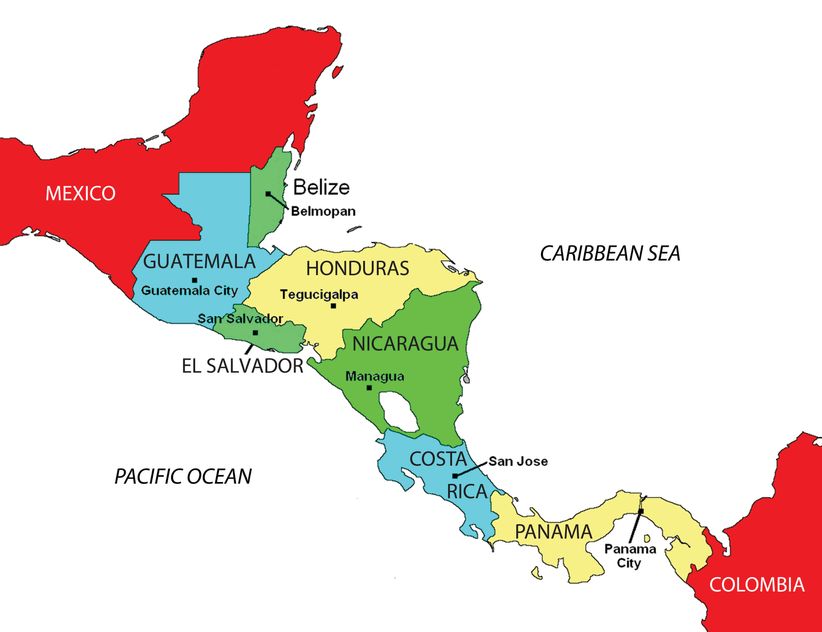
Map depicting the seven countries of Central America and their capitals.