The Geography of Peru: A Journey Through Diverse Landscapes
Peru, situated on the western coast of South America, is among the continent's most geographically diverse nations. Bordering five countries, its varied landscape comprises three primary geographical regions: the coastal desert, the towering Andes Mountains, and the expansive Amazon Basin.
 https://www.flickr.com/photos/slack12/446547786")
 https://www.flickr.com/photos/68018236@N03/24109238572")
 https://www.flickr.com/photos/68018236@N03/32587758771")


Peru's Geographic Tapestry: From Pacific Shores to Amazonian Depths
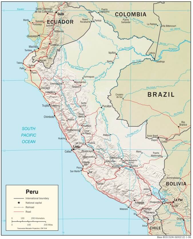
Peru stands as one of South America's most geographically complex and ecologically diverse nations, encompassing approximately 1.28 million square kilometers (494,200 square miles) of dramatically varied terrain. Strategically positioned on the western coast of South America, Peru shares borders with Ecuador and Colombia to the north, Brazil and Bolivia to the east, and Chile to the south, facing the vast Pacific Ocean to the west. This remarkable nation is traditionally divided into three distinct geographical regions: the coastal desert strip known as "la costa," the towering Andes Mountains referred to as "la sierra," and the expansive Amazon Basin known as "la selva."
Peru's intricate geographical mosaic has profoundly influenced its climate patterns, extraordinary biodiversity, and human settlement dynamics across millennia. The coastal region serves as the nation's demographic and economic powerhouse while harboring ancient archaeological treasures. The Andes function as Peru's natural water tower, providing essential resources while preserving rich Indigenous cultures. The Amazon rainforest, which covers more than half of the country, represents one of Earth's most biodiverse ecosystems and supports numerous Indigenous communities whose traditional knowledge systems remain largely intact.
The Coastal Region: Desert Oases and Urban Metropolises
Arid Landscapes and Demographic Concentration
Peru's coastal region extends for over 2,400 km (1,490 mi) along the Pacific Ocean, forming a narrow desert corridor that rarely exceeds 180 km (112 mi) in width. This seemingly inhospitable strip paradoxically supports nearly 60% of Peru's 33 million inhabitants, with major urban centers including Lima (population 10.5 million), Trujillo (1.1 million), and Chiclayo (850,000) thriving despite the arid conditions.
The coastal desert represents one of the world's most extreme arid environments, with some areas receiving less than 2 mm (0.08 in) of annual rainfall. The Sechura Desert in northwestern Peru and the northern extension of the Atacama Desert in the south create landscapes of extraordinary aridity, where years may pass without measurable precipitation. However, this apparent desolation is punctuated by approximately 53 river valleys that descend from the Andes, creating ribbon-like oases of fertility.
These river valleys, known as "valles costeños," have become Peru's agricultural heartland, producing export crops worth billions of dollars annually. The region's year-round growing season and controlled irrigation systems support intensive cultivation of asparagus, grapes, avocados, mangoes, and increasingly, blueberries and quinoa. The Ica Valley alone produces over 40% of Peru's wine and pisco, while the Chavimochic irrigation project has transformed 144,000 hectares (355,700 acres) of desert into productive farmland.
Ancient Civilizations and Archaeological Marvels
The coastal region serves as an open-air museum of pre-Columbian civilizations, with archaeological sites spanning over 5,000 years of human occupation. The Nazca Lines, created between 500 BCE and 500 CE, consist of over 800 straight lines, 300 geometric figures, and 70 animal and plant designs etched into the desert floor across 450 square kilometers (174 square miles). These geoglyphs, some extending over 30 km (19 mi) in length, remain one of archaeology's greatest enigmas.
The Moche civilization (100-700 CE) left behind the impressive Huacas del Sol y de la Luna near Trujillo, with the Huaca del Sol originally standing 50 m (164 ft) tall and constructed from over 143 million adobe bricks. The later Chimú culture (900-1470 CE) built Chan Chan, the largest pre-Columbian city in the Americas, covering 20 km² (7.7 mi²) with elaborate mud-brick palaces, temples, and workshops that once housed 60,000 inhabitants.
The Paracas culture (800-100 BCE) produced some of the world's finest ancient textiles, with burial shrouds containing over 200 colors and intricate designs that remain vibrant after 2,000 years. Recent discoveries at Caral, dating to 3500 BCE, reveal one of the world's oldest urban centers, predating the Egyptian pyramids by several centuries.
Marine Ecosystems and Economic Significance
The coastal waters benefit from the cold, nutrient-rich Humboldt Current, which creates one of the world's most productive marine ecosystems. This current, flowing northward from Antarctica, brings cold water temperatures averaging 18-20°C (64-68°F) and supports massive populations of anchovies, sardines, and other fish species. Peru consistently ranks among the world's top five fishing nations, with annual catches exceeding 4 million tons.
The phenomenon of El Niño, occurring every 3-7 years, dramatically alters these coastal conditions, bringing warm water temperatures that can rise to 28°C (82°F) and causing devastating floods, droughts, and ecological disruptions throughout the region.
Peru physiographic map.
The Andes Mountains: Peru's Towering Backbone
Geological Grandeur and Hydrological Importance
The Peruvian Andes represent the world's longest continental mountain range, extending approximately 1,500 km (930 mi) through the country from north to south. This massive cordillera divides into three primary ranges: the Cordillera Occidental (Western Range), Cordillera Central (Central Range), and Cordillera Oriental (Eastern Range), with numerous peaks exceeding 6,000 m (19,685 ft) in elevation.
Huascarán, Peru's highest peak at 6,768 m (22,205 ft), anchors the Cordillera Blanca, which contains 27 peaks over 6,000 m (19,685 ft) and represents the world's highest tropical mountain range. The Cordillera Huayhuash, though smaller, includes several peaks exceeding 6,000 m (19,685 ft), including Yerupajá at 6,617 m (21,709 ft).
The Andes serve as Peru's primary water source, with over 3,000 glaciers covering approximately 2,000 square kilometers (772 square miles). These glaciers, along with high-altitude lakes and wetlands, feed major river systems, including the Amazon, which begins its 6,400 km (4,000 mi) journey to the Atlantic Ocean from these Andean slopes. The Marañón River, considered the Amazon's primary source, originates at 5,800 m (19,029 ft) on Nevado Mismi.
The Altiplano and High-Altitude Ecosystems
The southern Andes encompass portions of the Altiplano, a vast high-altitude plateau averaging 3,750 m (12,303 ft) in elevation and extending over 105,000 km² (40,540 mi²) across Peru, Bolivia, northern Chile, and northwestern Argentina. This unique ecosystem, characterized by extreme temperature variations and thin air containing 40% less oxygen than at sea level, supports specialized flora and fauna adapted to harsh conditions.
The puna grasslands, found above 3,500 m (11,480 ft), sustain approximately 500 plant species and serve as grazing grounds for South American camelids. Wild vicuñas and guanacos roam these high plains alongside domesticated llamas and alpacas, which have been integral to Andean culture for over 6,000 years. The region's 600,000 alpacas produce some of the world's finest natural fiber, with fleece selling for up to $400 per pound.
Cultural Heritage and Archaeological Significance
The Andes preserve Peru's most significant archaeological and cultural heritage, comprising over 100,000 documented sites that range from small ceremonial platforms to massive urban complexes. Machu Picchu, designated a UNESCO World Heritage Site in 1983, represents the pinnacle of Inca architectural achievement. This mountaintop citadel, constructed around 1450 CE at an elevation of 2,430 m (7,970 ft), demonstrates sophisticated engineering techniques, including anti-seismic construction methods and advanced agricultural terracing.
The Sacred Valley, stretching 100 km (62 mi) between Cusco and Machu Picchu, contains numerous archaeological sites, including Pisac, with its impressive agricultural terraces covering 40 hectares (99 acres), and Ollantaytambo, one of the few Inca towns still inhabited by descendants of its original residents. The valley's 2,800 m (9,186 ft) elevation provides ideal conditions for cultivating over 600 native potato varieties and numerous other Andean crops.
Cusco, the former Inca capital at an elevation of 3,400 m (11,155 ft), exemplifies the cultural synthesis between Indigenous and Spanish colonial traditions. The city's population of 430,000 comprises approximately 47% Indigenous people, primarily Quechua speakers who continue to practice traditional customs in textiles, agriculture, and spiritual ceremonies.
Climate Zones and Biodiversity
The Andes create multiple climate zones within relatively short distances, ranging from tropical conditions in the lower valleys to arctic conditions above 4,800 m (15,748 ft). The eastern Andean slopes, facing the Amazon Basin, receive significantly more precipitation than the western slopes, creating distinct ecological gradients.
The cloud forests of the eastern slopes, occurring between 1,500-3,500 m (4,921-11,480 ft) elevation, represent one of the world's most biodiverse ecosystems. These misty forests support over 3,000 plant species per hectare and serve as habitat for endangered species, including the spectacled bear, Peru's only native bear species, and the yellow-tailed woolly monkey.
The Amazon Basin: Earth's Greatest Biological Treasury
Ecological Supremacy and Global Significance
The Peruvian Amazon, also known as "La Selva," spans approximately 782,000 km² (302,000 mi²), accounting for 60% of the country's territory and 13% of the entire Amazon Basin. This vast wilderness contains an estimated 10% of the world's known species within just 0.13% of Earth's surface area, making it the most biodiverse region on the planet.
The Amazon's three-tiered forest structure creates multiple ecological niches: the emergent layer, which reaches heights of 60 m (197 ft), the dense canopy layer at 30-45 m (98-148 ft), and the understory layer, which receives less than 2% of the sunlight. This vertical stratification supports extraordinary species diversity, with single trees hosting over 400 insect species and individual hectares containing more tree species than the entire continent of North America.
Hydrological Networks and River Systems
The Peruvian Amazon's river network spans over 100,000 km (62,137 mi) of navigable waterways, serving as highways for remote communities where roads are virtually nonexistent. The Ucayali River, Peru's longest at 1,771 km (1,100 mi), joins the Marañón River to form the Amazon River, the longest river in the world. During flood season, river levels can rise 10-15 m (33-49 ft), inundating vast areas of forest and creating temporary lakes covering thousands of square kilometers.
The region's annual precipitation ranges from 1,800 to 3,000 mm (71-118 in), with some areas receiving over 4,000 mm (157 in) annually. This massive hydrological cycle processes approximately 20% of the world's freshwater, with the Amazon River alone discharging 200,000 cubic meters (7 million cubic feet) of water per second into the Atlantic Ocean.
Indigenous Peoples and Cultural Diversity
The Peruvian Amazon supports 64 Indigenous groups speaking 47 different languages from 19 linguistic families, representing approximately 400,000 people or 60% of Peru's Indigenous population. The Asháninka, numbering approximately 100,000, constitute the largest Amazonian ethnic group, while smaller groups, such as the Matsés (3,000 people) and Shipibo-Conibo (35,000 people), maintain distinct cultural practices and traditional ecological knowledge.
These communities have developed a sophisticated understanding of forest ecosystems, utilizing over 3,000 plant species for food, medicine, construction, and spiritual purposes. The Shipibo people's intricate geometric patterns, applied to textiles and ceramics, reflect their profound understanding of plant spirits and the natural energy flows that surround them. Many groups practice sustainable agroforestry systems that maintain forest cover while producing a diverse range of crops.
Approximately 15-20 Indigenous groups remain in voluntary isolation, living in territories totaling 2.8 million hectares (6.9 million acres) under government protection. These populations, estimated to be between 7,000 and 15,000 people, represent humanity's last remaining hunter-gatherer societies and serve as guardians of pristine forest ecosystems.
Conservation Challenges and Protected Areas
The Peruvian Amazon faces mounting pressures from deforestation, illegal mining, coca cultivation, and infrastructure development. Annual deforestation rates fluctuate between 150,000 and 200,000 hectares (370,000 and 494,000 acres), with illegal gold mining causing mercury contamination in major river systems. The Madre de Dios region alone contains an estimated 50,000 illegal miners operating in pristine watersheds.
Peru has established 76 protected areas covering 22.5 million hectares (55.6 million acres), including 15 national parks, 25 national reserves, and nine national sanctuaries. Manú National Park, covering 1.5 million hectares (3.7 million acres), protects the complete ecosystem gradient from Andean peaks to lowland rainforest and harbors over 1,000 bird species—more than the United States and Canada combined.
The Pacaya-Samiria National Reserve, covering 2.1 million hectares (5.2 million acres), represents the largest protected wetland in Peru and supports over 450 bird species, 102 mammal species, and 256 fish species. These protected areas serve as crucial refuges for endangered species, including jaguars, giant otters, harpy eagles, and pink river dolphins.
Hydrological Treasures: Lakes and Rivers
Lake Titicaca: The Sacred Sea
Lake Titicaca, shared between Peru and Bolivia, is the largest lake in South America by volume and the world's highest navigable lake, situated at an elevation of 3,812 m (12,507 ft) above sea level. This ancient lake, covering 8,372 km² (3,232 mi²), reaches maximum depths of 284 m (932 ft) and contains 29 islands, including the famous floating islands of the Uros people.
The lake's unique ecosystem supports 23 endemic species, including the giant Titicaca frog, which can reach 50 cm (20 in) in length and weigh up to 1 kg (2.2 lbs). The lake's cultural significance extends back 3,000 years, with the Tiwanaku civilization considering it the birthplace of their creation myths.
Mountain Lakes and Glacial Systems
The Andes contain over 12,000 glacial lakes, many of which were formed by retreating glaciers that have lost approximately 30% of their area since 1970 due to climate change. Lake Junín, Peru's second-largest lake at an elevation of 4,080 m (13,386 ft), supports endemic bird species, including the Junín grebe, and serves as a crucial stopover for migratory waterfowl.
The 69 Lakes region in Huascarán National Park showcases spectacular glacial formations, with turquoise lakes nestled among snow-capped peaks. These high-altitude lakes serve as natural water reservoirs, gradually releasing meltwater during dry seasons to sustain agricultural activities in lower valleys.
Amazonian Waterways and Oxbow Lakes
The Amazon Basin contains thousands of oxbow lakes formed by meandering river channels, which create crucial habitats for aquatic species. Lake Sandoval in Tambopata National Reserve exemplifies these pristine ecosystems, supporting giant otters, caimans, and over 200 bird species within its 127-hectare (314-acre) expanse.
The region's blackwater rivers, stained dark by dissolved organic matter, create distinctly different ecosystems from those of whitewater rivers, which carry Andean sediments. These chemical differences support unique fish communities, with the Rio Negro system alone harboring over 700 fish species.
Conclusion: A Geographic Mosaic of Global Significance
Peru's extraordinary geographic diversity—from the hyperarid Atacama Desert to the snow-capped Andes to the verdant Amazon rainforest—creates a nation of unparalleled ecological and cultural richness. This geographic complexity supports 84 of the world's 117 recognized ecosystems, making Peru one of the 17 megadiverse countries containing the majority of Earth's species.
The coastal region's agricultural productivity and urban centers drive Peru's $230 billion economy, while the Andes provide essential water resources and preserve ancient cultural traditions. The Amazon Basin serves as a global climate regulator, storing 15-20 billion tons of carbon and producing 20% of the world's oxygen while supporting Indigenous communities whose traditional knowledge offers crucial insights for sustainable development.
Understanding Peru's geographic intricacy reveals the interconnected nature of climate, biodiversity, and human culture across vastly different environments. The challenges of climate change, deforestation, and urbanization necessitate integrated approaches that acknowledge these geographic interrelationships. Preserving Peru's natural heritage ensures that future generations can continue to benefit from the ecological services, cultural wisdom, and natural beauty that define this remarkable nation.
Peru's geographic tapestry represents not merely a collection of distinct regions but a unified system where coastal deserts, mountain peaks, and rainforest depths combine to create one of Earth's most extraordinary countries—a living laboratory for understanding the complex relationships between geography, climate, and human civilization.