


Chile's National Park System and the Route of Parks of Patagonia
Chile's vast national park system is a testament to its commitment to preserving its natural heritage. These protected areas, from the Atacama Desert to Tierra del Fuego, harbor diverse ecosystems and abundant biodiversity. The system's crown jewel is the Route of Parks of Patagonia.

 - via Wikimedia Commons")
 https://www.flickr.com/photos/37457628@N00/3290992549/")
 from lagoon (Laguna Tempanos) in Queulat National Park, Chile - by Dan Lundberg (CC BY-SA 2.0) https://www.flickr.com/photos/9508280@N07/8519667983/")

")
 https://www.flickr.com/photos/lindadevolder/31819969614/")


_ via Wikimedia Commons")
]")
Chile's National Park System and the Route of Parks: A Conservation Triumph Spanning a Continent
Chile's national park system stands as one of the world's most ambitious conservation achievements—a network of protected areas stretching more than 4,300 kilometers (2,670 miles) from the driest desert on Earth to the storm-lashed islands at the edge of Antarctica. Administered by the National Forest Corporation (CONAF), this system encompasses extraordinary ecosystem diversity, from hyper-arid coastal deserts through temperate rainforests where ancient alerce trees have witnessed millennia, to the windswept steppes and massive ice fields of Patagonia.
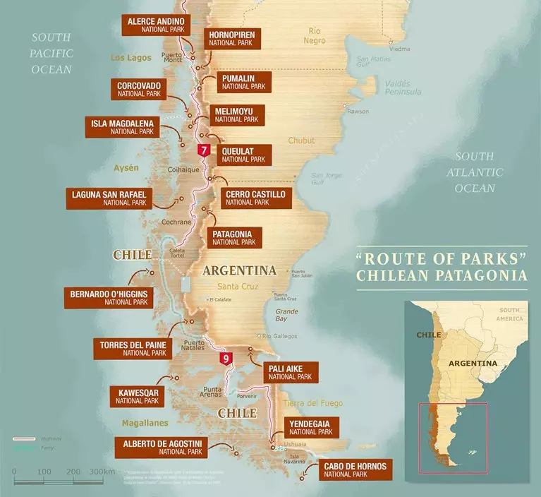
The crown jewel is the Route of Parks of Patagonia—a visionary corridor connecting 17 national parks across 2,800 kilometers (1,740 miles), creating one of the world's most extensive protected wilderness networks spanning more than 11 million hectares (27 million acres)—an area larger than Iceland.
A Landscape-Scale Vision: The Tompkins Legacy
The Route of Parks emerged from the remarkable conservation vision of Douglas and Kristine McDivitt Tompkins. Doug Tompkins, co-founder of The North Face and Esprit, transformed from an outdoor entrepreneur to a conservationist in the 1990s. Alongside Kristine, former CEO of Patagonia, Inc., they began acquiring vast tracts of Chilean and Argentine Patagonia—not for personal use, but for restoration and permanent protection.
Their strategy was revolutionary: restore degraded lands, reintroduce locally extinct species, and ultimately donate properties to Chile's government for incorporation into the national park system. They understood that effective conservation required engaging local communities and creating economic alternatives through nature-based tourism.
After Doug's death in a 2015 kayaking accident, Kristine continued their vision. In 2017, Tompkins Conservation donated approximately 407,625 hectares (1,007,000 acres) to Chile—the largest private land donation in history. Combined with government commitments, this created or expanded several national parks and established the Route of Parks in 2018, demonstrating how private philanthropy and government collaboration can achieve landscape-scale conservation.
Chile's Route of Parks map - Thompson Conservation
The Route of Parks: A Journey Through Chile's Wilderness Heart
The Route of Parks traverses Chilean Patagonia from Puerto Montt in the Los Lagos Region southward through the Aysén and Magallanes regions to Cape Horn at the continent's southern extremity. This "Parks Highway" showcases Chile's dramatic natural diversity while promoting sustainable tourism that benefits local communities and reinforces the economic value of conservation.
Los Lagos Region: Gateway to the Temperate Rainforest
The Route begins in the Los Lagos Region, where temperate rainforests cloak volcanic mountains and crystalline lakes reflect cloud-shrouded peaks.
Alerce Andino National Park (39,255 hectares/97,000 acres) protects ancient alerce trees that can live over 3,600 years—among Earth's oldest organisms. These majestic conifers reach 45 meters (148 feet) in height and 4 meters (13 feet) in diameter, surviving in mist-shrouded mountains where endemic species thrive in ecological communities unchanged for millennia.
Hornopirén National Park (48,232 hectares/119,170 acres) marks the transition where the Central Valley gives way to northern Patagonia's fractured geography. Accessible primarily by boat through intricate fjord systems, it protects pristine watersheds, active volcanoes, and remote temperate rainforests virtually untouched by human activity.
Pumalín Douglas Tompkins National Park encompasses 325,000 hectares (803,000 acres) of temperate rainforest—one of the largest parks protecting this globally rare ecosystem. Named for Doug Tompkins, the park features cathedral-like canopies of coigüe, tepa, and mañío trees, cascading waterfalls, and habitat for pudú (the world's smallest deer), Darwin's foxes, and endangered huemul.
Corcovado National Park (293,986 hectares/726,480 acres) centers on the ice-capped Corcovado Volcano, rising 2,300 meters (7,546 feet) directly from sea level. Its diverse habitats support pumas, endangered Chilean river otters, and over 100 bird species.
Aysén Region: Where Ice Meets Forest
The Aysén Region represents the wildest section of the Route, with an extraordinary concentration of glaciers, fjords, and pristine wilderness.
Melimoyu National Park (81,000 hectares/200,156 acres) protects volcanic landscapes surrounding Melimoyu Volcano. Accessible primarily by boat, this remote park offers sanctuary for wildlife in largely unimpacted ecosystems.
Queulat National Park (154,093 hectares/380,732 acres) is renowned for the spectacular Ventisquero Colgante—the "Hanging Glacier"—descending from high mountains to a serene lagoon. Its ecosystems range from coastal fjords to temperate rainforests to alpine zones, supporting endangered huemul deer and Patagonian pumas.
Isla Magdalena National Park (157,616 hectares/389,424 acres) protects fjord and island ecosystems critical for marine wildlife, including one of Chile's largest Magellanic penguin colonies, South American sea lions, marine otters, and diverse seabirds. Historical sites include an old lighthouse and remnants of a penal colony.
Cerro Castillo National Park (179,550 hectares/443,655 acres) features the dramatic jagged peaks of the Cerro Castillo range. The challenging Cerro Castillo Circuit trek attracts adventurous hikers, while the park protects crucial habitat for surviving huemul deer populations.
Laguna San Rafael National Park, covering an enormous 1,742,000 hectares (4,304,000 acres), encompasses the spectacular San Rafael Glacier, which calves enormous ice chunks into the lagoon. The park protects extensive sections of the Northern Patagonian Ice Field and pristine fjords, home to dolphins, seals, and whales.
Patagonia National Park (304,525 hectares/752,476 acres) embodies the Tompkins' vision. Created from former sheep estancias, it has undergone extensive restoration, including fence removal, species reintroductions, and the removal of non-native species. Diverse landscapes span from the Patagonian steppe to mountain peaks, with growing populations of guanacos, rheas, Andean condors, and pumas demonstrating the success of restoration.
Magallanes Region: The Edge of the World
The southernmost section traverses landscapes where Patagonia reaches its most extreme expressions—massive glaciers, fierce winds, and wilderness that challenges human presence while inspiring awe.
Bernardo O'Higgins National Park, Chile's largest at 3,525,901 hectares (8,711,087 acres), encompasses vast sections of the Southern Patagonian Ice Field, pristine fjords, temperate rainforests, and dramatic mountain ranges. Visitors access the park primarily by boat, and they witness the towering Serrano and Balmaceda glaciers. Its remoteness ensures ecosystems function with minimal human interference.
Torres del Paine National Park (227,298 hectares/561,525 acres) ranks among the world's most celebrated protected areas. The iconic granite "Torres"—towers rising vertically more than 900 meters (2,950 feet)—attract global visitors. The park encompasses extraordinary diversity: turquoise lakes, massive glaciers, Patagonian steppe with guanacos and rheas, and southern beech forests, all supporting remarkable wildlife, including pumas, Andean condors, and the endangered huemul.
Pali-Aike National Park (5,030 hectares/12,426 acres) preserves a surreal volcanic landscape of ancient craters, lava fields, and wind-sculpted formations. Archaeological sites reveal thousands of years of human occupation in this harsh environment.
Kawésqar National Park (2,842,329 hectares/7,022,000 acres), Chile's second-largest, encompasses intricate fjord systems, glaciers, dense forests, and thousands of islands. Named for the Kawésqar people who navigated these waters for millennia, it protects marine and terrestrial ecosystems of global significance in one of Earth's last truly wild places.
Yendegaia National Park (150,612 hectares/372,140 acres) on Tierra del Fuego protects wilderness from the Beagle Channel to the Argentine border, through forests and mountains. Its name means "deep bay" in the Yaghan language, honoring the Indigenous people who inhabited these lands. Wildlife includes Andean deer, Magellanic woodpeckers, and Andean condors.
Alberto de Agostini National Park (1,460,000 hectares/3,607,800 acres) features the Darwin Mountain Range—jagged peaks rising directly from the sea—and the massive Marinelli Glacier. Accessible primarily by boat through the Beagle Channel, it offers views of untouched wilderness where mountains, forests, and ocean converge dramatically.
Cabo de Hornos National Park (63,093 hectares/155,900 acres) protects the southern tip of South America, including Cape Horn—one of history's most storied maritime landmarks. At the meeting point of the Atlantic and Pacific, it experiences some of Earth's most challenging conditions. The park protects unique sub-Antarctic ecosystems and holds profound historical significance.
Biodiversity Across Latitudes
Chile's unique geography—spanning 38 degrees of latitude and averaging only 177 kilometers (110 miles) wide—creates extraordinary biological diversity. The parks protect temperate rainforests where rainfall can exceed 4,000 millimeters (157 inches) annually, harboring ancient alerce and southern beech trees. Patagonian steppe ecosystems support guanacos, rheas, Patagonian foxes, and raptors. Alpine zones provide habitat for endangered huemul deer, mountain vizcachas, and Andean condors. Coastal and marine environments support seabird colonies, dolphins, whales, and crucial fish populations.
Endemic species found nowhere else include Darwin's fox, the Chilean palm (the southernmost palm species), and numerous adapted plants and invertebrates. The parks serve as refuges for threatened species, including the South Andean huemul, Chilean river otter, and various endemic birds.
Conservation Challenges and Adaptive Management
Despite legal protection, Chile's parks face ongoing challenges. Climate change impacts are increasingly visible through glacier retreat, shifting precipitation patterns, and contracting species ranges. Tourism, while generating economic benefits, requires careful management to prevent degradation. Infrastructure development proposals occasionally threaten park boundaries or connectivity.
Chile has responded with sophisticated management strategies: improved ranger training, increased surveillance capabilities, community engagement programs that involve local residents in decisions and ensure tourism benefits reach local economies, scientific monitoring programs, and international partnerships. The Route of Parks initiative demonstrates that conservation can drive sustainable economic development through nature-based tourism, with early evidence showing that increased tourism creates jobs while strengthening public support for conservation.
A Model for Global Conservation
Chile's national park system offers valuable lessons worldwide. The Tompkins' willingness to donate enormous land holdings demonstrates that private wealth can achieve landscape-scale conservation. By accepting these donations and committing its own lands, Chile's government showed rare political leadership. Together, they proved that private philanthropy, government commitment, local community involvement, and sustainable tourism can combine for lasting conservation success—shifting the perception of protected wilderness from luxury to sound economic policy with tangible value through tourism, ecosystem services, and international reputation.
Conclusion: A Legacy for Generations
Chile's national park system and the Route of Parks stand as monuments to vision, dedication, and collaboration. From ancient alerce forests to volcanic Patagonian landscapes, and from the storm-lashed southern islands, these protected areas safeguard some of Earth's most remarkable wilderness.
The Tompkins' legacy lives on in the conservation philosophy they championed—seeing humans as part of nature, restoring damaged lands rather than only preserving pristine areas, and ensuring conservation succeeds when local communities benefit. For Chile, these parks define national identity and global reputation. For the world, they offer hope that transformative conservation remains possible even amid an environmental crisis.
The Route of Parks demonstrates that with vision, commitment, and collaboration, we can protect wild places that sustain both human communities and countless species. Visitors witness landscapes shaped by ice and fire, forests that have stood for millennia, and wildlife populations surviving against long odds—proof that conservation can succeed, wilderness can be protected, and the natural world demonstrates remarkable resilience when given the chance. This is the promise and triumph of Chile's national park system and the Route of Parks of Patagonia.