
Huascarán National Park: Peru's Tropical Ice and Wet Puna
Huascarán National Park protects 3,400 km² (1,313 sq mi) of the Cordillera Blanca in Peru's Áncash region, with Peru's highest peak, hundreds of glaciers and lakes, and the giant Puya raimondii. This article covers its ecology, archaeology, retreating ice, and the flood risk above Huaraz.


Huascarán National Park: A Sanctuary of Biodiversity and Human History
Huascarán National Park protects the heart of the Cordillera Blanca, the world's highest tropical mountain range, in the Áncash region of the central Peruvian Andes. It covers 340,000 ha (3,400 km², 1,313 sq mi) and rises to Nevado Huascarán, which at 6,768 m (22,205 ft) is the highest peak in Peru. Its summits, glaciers, turquoise glacial lakes and giant flowering plants make it one of the most dramatic landscapes in the Andes, and its meltwater supplies towns and farms from the Callejón de Huaylas to the Pacific coast. It is also a landscape under pressure: its glaciers are retreating, its lakes pose a flood risk to the city below, and mining, grazing and tourism all press on its edges. This article describes the park's setting, its ice and water, its plants and animals, its archaeological heritage and the challenges it now faces.
A Park in the Heart of the Cordillera Blanca
The park occupies the western slopes of the central Andes along the Cordillera Blanca, one of the highest ranges of the Peruvian Andes. It was created on July 1, 1975, by Supreme Decree 0622-75-AG and spans ten provinces of Áncash. UNESCO recognized it as a Biosphere Reserve in 1977 and as a World Heritage Site in 1985, under natural criteria (vii) and (viii) for its scenic beauty and its record of glacial and geological processes. The biosphere reserve is larger than the park: the park forms its protected core, and a buffer zone and transition area around it bring the reserve to an area reported as 1,155,800 ha (11,558 km², 4,462 sq mi) and about 360,000 residents.
Peaks and Ice
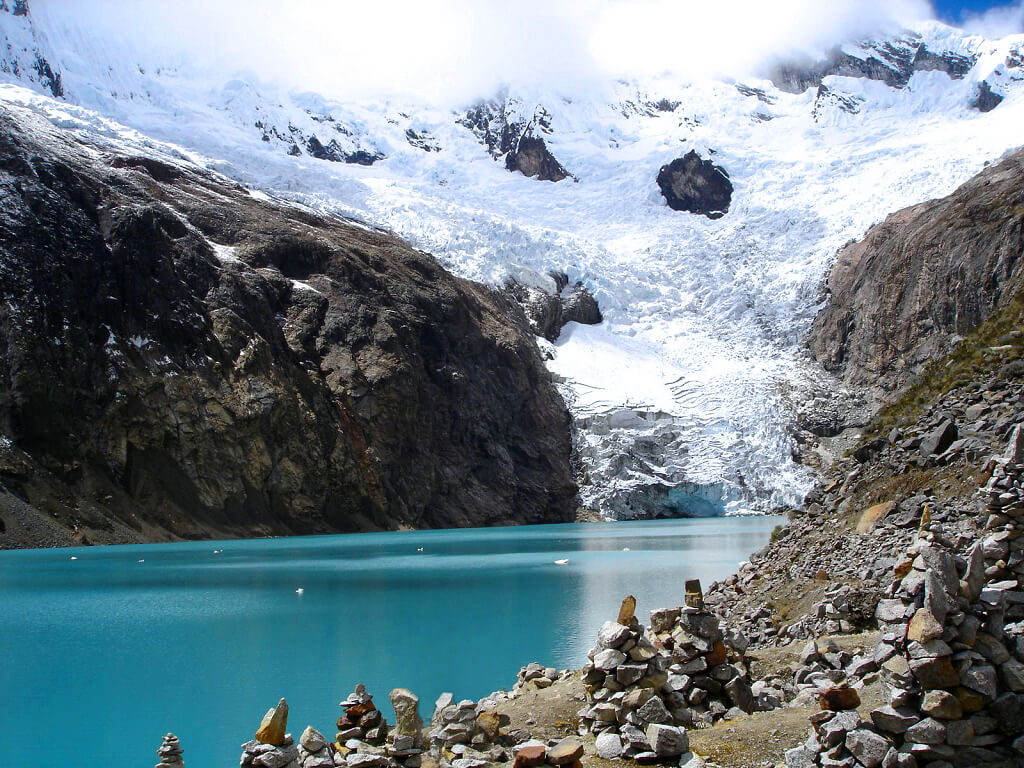
Nevado Huascarán has two summits, a south peak of 6,768 m (22,205 ft) and a north peak of 6,655 m (21,834 ft). The park contains 27 snow-capped peaks above 6,000 m (19,685 ft), and its summits range from about 5,000 m (16,400 ft) upward. Reported glacier counts vary with the inventory and the year, from more than 600 to about 710, and the number of glacial lakes is reported as roughly 300 to 430. The park sits within the Santa, Pativilca, and Marañón river basins, and 41 tributaries of these rivers rise within its boundaries. East-side runoff reaches the Atlantic through the Marañón River and then the Amazon River, while west-side runoff reaches the Pacific through the Santa.
Retreating Glaciers
The ice is shrinking. UNESCO notes that roughly a quarter of the Cordillera Blanca's glacial ice volume may have disappeared since the late 1960s, and Peru's national water authority documented the loss glacier by glacier in its study of the range between 1948 and 2018. The Yanamarey glacier retreated 974 m (3,196 ft) over that period, averaging about 5 m (16 ft) a year until 1980 and 22 m (72 ft) a year afterward, and the authority describes it as disappearing. The Pastoruri glacier, once a major tourist stop, has split into three parts and formed a new lake that held more than 700,000 m³ (25 million cu ft) of water by 2017. A park report also cites a rise of about 0.7 °C (1.3 °F) in Andean temperatures over the last 30 years.
Lakes, Water and Flood Risk
The park's meltwater feeds the Santa River, which supplies Huaraz, Yungay and Recuay, and irrigates the Chao, Virú and Chicama valleys on the coast, where specialists say it contributes a large share of the water used by northern agribusiness. The same lakes are also a hazard. Where glaciers retreat, meltwater collects behind moraines and can burst through them in an outburst flood. Lake Palcacocha above Huaraz has grown to more than 30 times its historic volume, and about 50,000 people live in the flood path. A farmer from Huaraz, Saúl Luciano Lliuya, took the German energy company RWE to court over its share of the emissions behind the problem, and on May 28, 2025, a court in Hamm ruled against him because it put the chance of a flood within 30 years at just over 1 percent, below the legal threshold for liability. The ruling ended a decade-long case. The mountain's history shows that other hazards exist too: Huascarán's north peak shed a vast avalanche during the 1970 Áncash earthquake that buried the town of Yungay.
Life Zones of the Wet Puna
The park lies within the Central Andean wet puna ecoregion. Relict forests of queñua (Polylepis species) and quishuar (Buddleja incana) survive in sheltered valleys such as Llanganuco; high-altitude grasslands and cushion-plant turf cover the slopes above them, and wet meadows called bofedales form in poorly drained basins above 4,500 m (14,764 ft). In all, researchers have recorded 985 plant species in 374 genera and 114 families. The bromeliad known as the Queen of the Andes (Puya raimondii) is the park's most celebrated plant, a rosette that grows for decades before sending up a flowering spike several meters tall and then dying.
Wildlife
The park supports more than 210 bird species, 25 mammals, five amphibians, and four reptiles. Mammals include the spectacled bear (Tremarctos ornatus), the puma (Puma concolor), the taruca or North Andean deer (Hippocamelus antisensis), the Andean cat (Leopardus jacobita) and the vicuña (Vicugna vicugna), which recovered from near-extinction in the 1960s. Among the birds are the Andean condor (Vultur gryphus), the giant hummingbird (Patagona gigas), and the torrent duck (Merganetta armata), which lives in fast mountain streams.
Human History and Archaeology
People have lived in these valleys for thousands of years. Excavations at Guitarrero Cave and the Lauricocha sites record some of the earliest settlement in the Peruvian highlands, and Recuay culture sites, Hatun Machay and Honcopampa, add later periods. Terraces, corrals, roads, dams, and canals remain in the park, along with cave paintings and stone tombs. Just outside its boundary stands the temple of Chavín de Huántar, a major ceremonial center of the first millennium BCE, and a trekking route follows a pre-Inca road across the mountains to it. A cave gallery with condor images was discovered in 2022. Many Quechua-speaking communities still herd llamas and alpacas inside and around the park under customary rights.
Visiting the Park
The park receives an average of about 270,000 visitors a year, drawn by the multi-day Santa Cruz trek, the lakes of Llanganuco, Churup and Arhuaycocha, and climbing routes on the high peaks. The rainy season runs from December to March and the dry season from April to November, and the dry months are the usual season for trekking and climbing. Huaraz, at the foot of the range, is the main base.
Pressures on the Park
The park's own managers and UNESCO point to several threats beyond glacier retreat. Mining concessions and illegal mining camps have been reported inside or near the boundary despite the legal ban on mineral extraction in national parks, and planned dam construction is a further concern. Staffing and budgets have not kept pace with the park's size, and growing populations and livestock add grazing pressure. The valleys outside the boundary, especially the Callejón de Huaylas, are intensively used, and the area is seismically active.
Conclusion
Huascarán National Park is both a mountain sanctuary and a working landscape, valued for its peaks, endemic plants, and ancient heritage, and relied on for water by communities throughout Áncash and along the coast. As its glaciers shrink, the park will increasingly be judged by how well Peru can protect the water, hazards and human uses that depend on it.