The Geography of Chile: Exploring a Nation of Contrasts
Chile is one of the most geographically unique countries in the world, stretching like a narrow strip along South America's western coast between the Pacific Ocean and the Andes Mountains. This distinctive shape creates an extraordinary range of climates and landscapes within its boundaries.
 https://www.flickr.com/photos/gandalfblanco/13392770393")

 https://www.flickr.com/photos/ju-mo/11482596266/")
")


Chile's Extraordinary Geography: From Desert Extremes to Glacial Wilderness
Chile stands as one of the world's most geographically unique nations, stretching like a narrow ribbon along the western edge of South America. This remarkable country extends approximately 4,300 km (2,670 mi) from north to south while averaging a mere 177 km (110 mi) in width—a configuration that creates an unparalleled diversity of climates, ecosystems, and landscapes within a single national boundary. Bounded by the Pacific Ocean to the west and the formidable Andes Mountains to the east, Chile encompasses a diverse range of landscapes, from the world's driest desert to temperate rainforests and glacial fjords.
This extraordinary geographical diversity has profoundly shaped Chile's cultural identity, economic development, and ecological richness. The country naturally divides into several distinct regions, each presenting unique environmental characteristics and challenges. The mineral-rich Atacama Desert dominates the north, characterized by its otherworldly aridity, while the fertile Central Valley serves as the nation's agricultural and demographic heart. The southern regions transition into dense temperate forests, pristine lakes, and ancient glaciers, ultimately reaching the windswept wilderness of Patagonia. Chile's extensive Pacific coastline, stretching over 6,400 km (3,977 mi), further enhances its economic significance and ecological importance. Understanding Chile's geography reveals a nation of extraordinary contrasts and breathtaking natural beauty.
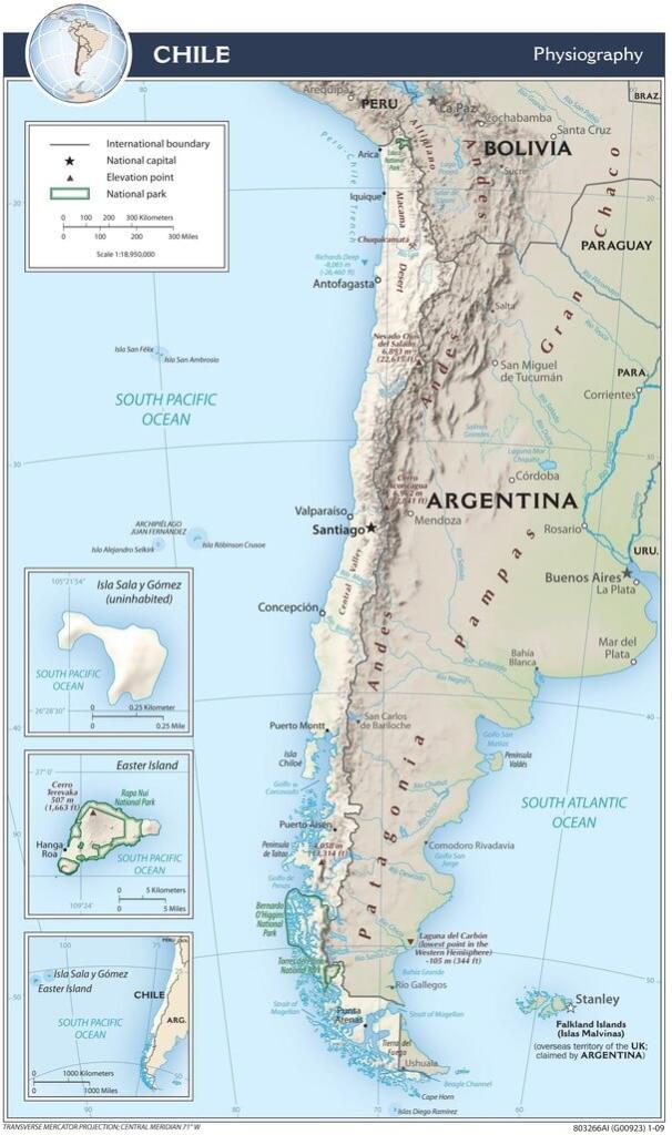
Physiographic map of Chile.
The Atacama Desert: Earth's Most Extreme Arid Landscape
The northernmost region of Chile is home to the Atacama Desert, widely recognized as the driest non-polar desert on Earth. This vast expanse covers approximately 105,000 km² (40,541 mi²) and experiences extraordinary aridity, with some weather stations recording no measurable rainfall for decades. The most arid areas receive less than 2 mm (0.08 in) of precipitation annually, creating conditions so extreme that NASA has used the region to test Mars rovers and space equipment.
The Atacama's severe dryness is a result of a unique combination of geographical factors. The towering Andes Mountains create a powerful rain shadow effect, blocking moisture-laden air masses from the east. Simultaneously, the cold Humboldt Current flowing northward along the Pacific coast creates a temperature inversion that prevents coastal moisture from penetrating inland. This dual barrier effect, combined with the region's high-pressure atmospheric conditions, creates one of the most stable and arid climates on the planet.
Despite its harsh conditions, the Atacama Desert represents one of the world's most economically valuable mineral regions. The desert contains approximately 28% of global copper reserves, with massive open-pit mines like Chuquicamata and Escondida operating as engineering marvels. The region also holds significant lithium deposits in its salt flats (salares), becoming increasingly important for battery production in the global transition to renewable energy. These mineral resources have made Chile the world's largest copper producer and a major lithium exporter.
The desert's landscape presents a stunning array of geological features. The Valle de la Luna (Valley of the Moon) features wind-carved rock formations and sand dunes, creating an almost alien terrain. The Salar de Atacama, Chile's largest salt flat at 3,000 km² (1,158 mi²), supports unique ecosystems including flamingo colonies that thrive in its mineral-rich lagoons. Geothermal fields dot the landscape, with geysers and hot springs creating dramatic steam clouds against the stark desert backdrop.
The Atacama's exceptional atmospheric conditions have also made it a global center for astronomical research. The combination of high altitude (averaging 2,400 m or 7,874 ft above sea level), minimal light pollution, clear skies over 300 days per year, and extremely low humidity creates ideal conditions for ground-based telescopes. The region hosts some of the world's most advanced observatories, including the European Southern Observatory's Very Large Telescope (VLT), the Atacama Large Millimeter Array (ALMA), and the future Extremely Large Telescope (ELT).
The Central Valley: Chile's Agricultural and Urban Foundation
South of the Atacama Desert lies the Central Valley, Chile's demographic and economic heartland. This fertile corridor, spanning approximately 400 km (249 mi) between the Andes and the Coastal Range, enjoys a Mediterranean climate characterized by warm, dry summers and mild, wet winters. The region's climate and soil conditions create ideal agricultural conditions, supporting over 60% of Chile's population and generating a significant portion of the country's GDP.
The Central Valley serves as Chile's agricultural powerhouse, producing a diverse range of crops that have established the country as a major food exporter. The region's vineyards produce world-renowned wines, particularly in the Maipo, Colchagua, Casablanca, and Aconcagua valleys. These wine regions benefit from distinct microclimates created by varying altitudes, soil compositions, and proximity to the ocean. Chile has become the world's fourth-largest wine exporter, with vineyards in the Central Valley accounting for the majority of its production.
Beyond viticulture, the Central Valley produces substantial quantities of fruits for both domestic consumption and export. The region's fruit orchards yield apples, pears, peaches, plums, and kiwis, while its fields produce wheat, corn, and legumes. Chile's counter-seasonal production relative to Northern Hemisphere markets has made it a crucial supplier of fresh fruit to North America, Europe, and Asia during their winter months.
The Central Valley is home to Santiago, Chile's capital and largest city, with a metropolitan population exceeding 7 million inhabitants. The city sits in a basin at approximately 520 m (1,706 ft) above sea level, surrounded by the Andes to the east and the Coastal Range to the west. This topographical setting, while providing dramatic mountain views, occasionally traps air pollution during the winter months when temperature inversions occur. Santiago serves as the nation's political, cultural, and economic center, housing major universities, museums, and corporate headquarters.
Other significant urban centers in the Central Valley include Valparaíso, a UNESCO World Heritage site renowned for its vibrant hillside neighborhoods, historic funiculars, and its importance as Chile's principal port. Concepción, located at the southern end of the Central Valley, serves as a major industrial hub and university town, while cities like Rancagua and Talca support the region's agricultural economy.
The Southern Lake District and Temperate Forests
As the Central Valley transitions southward, Chile's landscape transforms into a region of extraordinary natural beauty characterized by ancient forests, pristine lakes, and active volcanoes. The Lake District, extending from the Bío Bío River to Chiloé Island, features a complex network of glacial lakes set against the backdrop of snow-capped volcanic peaks. This region experiences a temperate oceanic climate, characterized by abundant rainfall, particularly during the winter months.
The district's most prominent lakes include Llanquihue, Chile's second-largest lake at 860 km² (332 mi²), which offers stunning views of the perfectly conical Osorno Volcano. Lake Villarrica, dominated by the active Villarrica Volcano, offers excellent recreational opportunities and is a popular tourist destination. Todos los Santos, also known as the "Emerald Lake" for its distinctive color, is situated within Vicente Pérez Rosales National Park and offers some of the region's most spectacular scenery.
This region is home to the Valdivian temperate rainforest, one of the most biodiverse and ecologically significant ecosystems in South America. These ancient forests, which survived the last ice age, contain species found nowhere else on Earth. The forest is dominated by remarkable trees, including the Alerce (Fitzroya cupressoides), which can live over 3,000 years and reach heights of 60 meters (197 feet), and the distinctive Araucaria (Araucaria araucana), commonly known as the monkey puzzle tree, which can live over 1,000 years.
The Valdivian forests support an incredible array of wildlife, including the elusive puma, the world's smallest deer species (pudú), and the endangered Darwin's fox. The region's rivers and lakes sustain healthy populations of native fish species, while the forest canopy provides habitat for numerous endemic bird species, including the Magellanic woodpecker and the Chilean pigeon.
Chiloé Island, located off the coast, presents a distinct cultural landscape shaped by its Indigenous Mapuche and Huilliche heritage. The island is renowned for its vibrant palafitos (traditional stilt houses), distinctive wooden churches (16 of which are UNESCO World Heritage sites), and rich mythology, featuring creatures such as the Trauco and Caleuche. The island's coastline boasts dramatic cliffs, protected fjords, and extensive wetlands, which serve as critical habitats for migrating whales, dolphins, and numerous seabird species.
Patagonia: The Ultimate Wilderness
Chilean Patagonia represents one of Earth's last great wildernesses, encompassing vast territories of glaciated mountains, windswept steppes, deep fjords, and isolated islands. This remote region, located south of Puerto Montt, spans approximately 240,000 square kilometers (92,664 square miles) and features some of the planet's most spectacular and challenging landscapes.
The Southern Patagonian Ice Field, covering 13,000 km² (5,019 mi²), stands as the world's third-largest ice mass outside Antarctica and Greenland. This massive ice field feeds numerous glaciers, including the famous Grey Glacier in Torres del Paine National Park and the Perito Moreno Glacier (shared with Argentina). These glaciers provide crucial freshwater resources and serve as indicators of climate change, with many showing significant retreat in recent decades.
Torres del Paine National Park, covering 2,420 km² (935 mi²), represents the crown jewel of Chilean Patagonia. The park's granite towers, or "torres," rise dramatically from the surrounding landscape, reaching heights of over 2,800 m (9,186 ft). The park's diverse ecosystems support guanacos, rheas, condors, and the elusive puma, making it one of the world's premier destinations for wildlife viewing. The park's challenging trekking circuits, including the famous "W" trek and the Circuit, attract adventurers from around the globe.
The region's complex system of fjords and channels, including the Strait of Magellan and the Beagle Channel, creates one of the world's most intricate maritime landscapes. These waterways were historically significant for Indigenous peoples, including the Kawésqar and Yaghan, who developed sophisticated maritime cultures that were well-adapted to the harsh conditions. Today, these channels serve as important routes for ecotourism and scientific research, providing access to remote glaciers and marine ecosystems.
The Pacific Coast and Marine Ecosystems
Chile's extensive Pacific coastline plays a crucial role in the country's economy, supporting one of the world's most productive marine ecosystems. The cold Humboldt Current, flowing northward along the coast, creates upwelling conditions that bring nutrient-rich deep waters to the surface, thereby supporting extraordinary marine productivity.
This coastal upwelling system sustains one of the world's largest fisheries, with Chilean waters producing significant quantities of anchovies, sardines, hake, and other species. The country ranks among the world's top fishing nations, with the industry providing employment for hundreds of thousands of people and generating substantial export revenues. The rich marine ecosystem also supports large populations of seabirds, marine mammals, and other marine life.
Chile's coastal geography varies dramatically from north to south. The northern coast features dramatic cliffs and small fishing villages, while the central coast includes major ports like Valparaíso and San Antonio. The southern coast becomes increasingly complex, with thousands of islands, fjords, and channels creating a maze-like maritime landscape.
Beyond the mainland, Chile governs several remote Pacific islands that add to the country's geographical diversity. Easter Island (Rapa Nui), situated 3,700 km (2,299 mi) from the mainland, is renowned for its enigmatic Moai statues and distinctive Polynesian culture. The Juan Fernández Archipelago, including Robinson Crusoe Island, harbors unique endemic species and serves as a UNESCO Biosphere Reserve. The Desventuradas Islands remain largely untouched and function as an important marine reserve.
The Andes Mountains: Chile's Geological Backbone
The Andes Mountains form Chile's natural eastern boundary, rising sharply from the Central Valley and extending the entire length of the country. This massive mountain range, part of the Pacific Ring of Fire, represents one of the world's most active geological zones, with numerous volcanoes, frequent seismic activity, and ongoing mountain-building processes.
The Chilean Andes reach their highest point at Ojos del Salado, which at 6,893 m (22,615 ft) stands as the world's tallest active volcano. The range contains over 45 active volcanoes, including Llaima, Villarrica, and Calbuco, which pose both hazards and opportunities for geothermal energy development. The mountains also harbor important mineral deposits, including the world's largest copper mines and significant gold, silver, and lithium resources.
The Andes serve as a crucial water source for Chile, capturing moisture from both Pacific and Atlantic weather systems. Glacial melt and seasonal snowpack provide essential freshwater for agriculture, urban areas, and hydroelectric power generation. The mountains also create diverse ecosystems, from high-altitude deserts in the north to alpine forests and meadows in the south.
Conclusion
Chile's geography represents one of nature's most extraordinary achievements, encompassing virtually every type of landscape and climate found on Earth within a single national boundary. From the otherworldly aridity of the Atacama Desert to the glacial wilderness of Patagonia, from the fertile valleys of the central region to the complex fjords of the south, Chile offers an unparalleled diversity of natural environments.
This remarkable geographical diversity has profoundly shaped Chilean society, economy, and culture. The country's mineral wealth has driven economic development, while its agricultural regions feed both domestic and international markets. The diverse ecosystems support unique biodiversity and provide essential environmental services, while the dramatic landscapes attract visitors from around the world.
Understanding Chile's geography reveals not just a nation of extraordinary natural beauty but a complex system of interconnected landscapes that continue to shape the country's development and identity. As Chile faces the challenges of the 21st century, including climate change and sustainable development, its remarkable geographical diversity will continue to be both a source of opportunity and a responsibility to preserve for future generations.