The Andean Volcanic Belt and the Pacific Ring of Fire: Unveiling Earth's Geological Marvels
The Andean Volcanic Belt and the Pacific Ring of Fire are areas where tectonic plates meet, causing volcanic activity and earthquakes. The Andean belt forms as the Nazca and Antarctic plates move beneath the South American Plate. The Pacific Ring of Fire hosts volcanoes, ocean trenches, arcs, and belts.

 https://www.flickr.com/photos/georigami/15340520506")
 asl, Baños, the Central Highlands, Ecuador - by Elias Rovielo (CC BY-NC-SA 2.0) https://www.flickr.com/photos/eliasroviello/49240020617")
 https://www.flickr.com/photos/harquail/16071575545")
 https://www.flickr.com/photos/jsjgeology/25430248347")

The Andean Volcanic Belt and the Pacific Ring of Fire: Unveiling Earth's Geological Marvels
The Andean Volcanic Belt, along South America's western coast, forms as the Nazca Plate and Antarctic Plate subduct beneath the South American Plate. This process generates various volcanic zones, illustrating the intricate interplay of Earth's crustal plates. The belt showcases diverse geological phenomena, from the hazards in the Northern Volcanic Zone to the silicic systems in the Central Volcanic Zone and the glaciated stratovolcanoes in the Austral Volcanic Zone.
Simultaneously, the Pacific Ring of Fire, encircling the Pacific Ocean, manifests the consequences of plate movements, evident in its extensive oceanic trenches, volcanic arcs, and belts. With over 450 volcanoes, this region, marked by seismic activity, highlights the pivotal role of plate tectonics in shaping the Earth's surface.
Andean Volcanic Belt
The Andean Volcanic Belt, a central volcanic powerhouse, graces the South American coast, weaving through Argentina, Bolivia, Chile, Colombia, Ecuador, and Peru. Its birth is rooted in the subduction of the Nazca and Antarctic tectonic plates beneath the South American Plate. This subduction process ignites volcanic activity, creating a mesmerizing volcanic belt that is a tapestry of diverse activity styles, products, and morphologies.
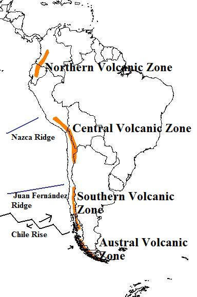
Map showing zones of the Andean Volcanic Belt.
Zonal Overview
The Andean Volcanic Belt unfolds its geological drama through four primary volcanic zones, separated by significant volcanic gaps. The Romeral stratovolcano in Colombia is the northernmost active member, while the Fueguino volcano in the Tierra del Fuego archipelago is the southernmost sentinel within the Austral Volcanic Zone.
Northern Volcanic Zone
The Northern Volcanic Zone (NVZ) spans from Colombia to Ecuador, encompassing all continental volcanoes within this region. Ecuador alone hosts 55 volcanoes, predominantly in the Cordillera Occidental and Cordillera Real, while Colombia contributes 19, mainly in the Western and Central Ranges. This volcanic zone poses significant hazards, particularly to densely populated highland areas where notable volcanoes such as Galeras and Nevado del Ruiz are found. The crustal thickness in the NVZ varies significantly, ranging from 40 km (25 mi) to potentially more than 55 km (35 mi).
Central Volcanic Zone
The Central Volcanic Zone (CVZ) extends from Peru to Chile and defines the western boundary of the Altiplano plateau, extending from Peru to Chile. This zone contains 44 major and 18 minor volcanic centers and showcases a continental crust thickness of approximately 70 km (44 mi). Large silicic volcanic systems, including those of the Altiplano–Puna Volcanic Complex, further enhance the CVZ's geological complexity.
Southern Volcanic Zone
The Southern Volcanic Zone (SVZ) stretches over 1,400 km (870 mi) from Central Chile to the Aysén Region. It results from the subduction of the Nazca Plate beneath the South American Plate. Its northern boundary is marked by the flat-slab subduction of the Juan Fernández Ridge, which introduces the Pampean flat-slab segment. The southern end culminates in the Chile Triple Junction, triggering the Patagonian Volcanic Gap and leading into the Austral Volcanic Zone.
Austral Volcanic Zone
The Austral Volcanic Zone (AVZ) extends over 965 km (600 mi) from the Patagonian Volcanic Gap to the Tierra del Fuego archipelago. Formed by the subduction of the Antarctic Plate beneath the South American Plate, the AVZ features eruptions primarily consisting of alkaline basalt and basanite. Glaciated stratovolcanoes and subglacial volcanoes beneath the Southern Patagonian Ice Field add a unique dimension to this volcanic zone.
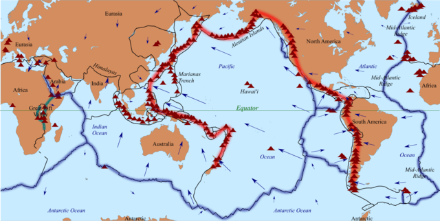
Map depicting the volcanic arcs that form the Ring of Fire.
Pacific Ring of Fire
The Pacific Ring of Fire is a seismic and volcanic extravaganza that emerges in the Pacific Ocean basin. This expansive horseshoe-shaped region results from the perpetual movement and collisions of lithospheric plates. It boasts a continuous series of oceanic trenches, volcanic arcs, volcanic belts, and various plate movements, painting a vivid geological canvas.
Magnitude and Frequency
The Ring of Fire is home to over 450 volcanoes and claims over 75% of the world's active and dormant volcanoes. Its seismic significance is underscored by staggering statistics: about 90% of the world's significant earthquakes and 80% of the most substantial eruptions in the last 11,700 years have originated within this dynamic zone.
Regional Impact
The influence of the Ring of Fire reverberates globally, with its eastern section profoundly affecting South America. Here, the subduction of the Nazca Plate and the Cocos Plate beneath the westward-moving South American Plate gives rise to the Andean Volcanic Belt. In Central America, the Cocos Plate undergoes subduction beneath the Caribbean Plate, birthing the Central America Volcanic Arc.
Key Volcanic Gaps
Peruvian flat slab segment (3 °S to 15 °S): A critical volcanic gap influencing the Andes region.
Pampean flat slab segment (27 °S to 33 °S): Marks a region devoid of volcanism due to a lower subduction angle caused by the Juan Fernández Ridge.
Patagonian Volcanic Gap (46 °S to 49 °S): This is the origin point of the Austral Volcanic Zone, characterized by rarely recorded eruptions and unexplored terrain until the 19th century.
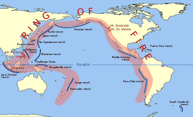
Map depicting the oceanic trenches that form the Pacific Ring of Fire.
Summary
In summary, the Andean Volcanic Belt and the Pacific Ring of Fire exemplify the geological consequences of plate tectonics. This exploration aims to provide a factual understanding of their formations, zonal characteristics, and the interconnected geological processes that have shaped these remarkable landscapes. These features, from seismic activities to volcanic eruptions, underscore the Earth's dynamic nature and continuous role in shaping its surface.