The Caribbean Plate: A Complex Oceanic Mosaic
The Caribbean Plate forms a unique oceanic tectonic entity beneath the Caribbean Sea and portions of Central America. This mainly oceanic plate is one of Earth's most tectonically complex areas, where interactions among four major plates create a wide variety of geological processes.

Oceanic Complexity: Understanding Caribbean Plate Tectonics
The Caribbean Plate forms a unique oceanic tectonic entity covering approximately 3.32 million square kilometers (1.28 million square miles) beneath the Caribbean Sea and portions of Central America. This predominantly oceanic plate represents one of Earth's most tectonically complex regions, where interactions between four major plates create a diverse array of geological processes, from active volcanism to transform faulting and subduction dynamics.
Geological Setting and Formation
The Caribbean Plate originated through complex processes that remain partially debated among geoscientists. The prevailing model suggests the plate formed from a portion of Pacific oceanic crust that migrated eastward through a gap between North and South America during the Late Cretaceous period, approximately 90-70 million years ago. Alternative theories propose in-situ formation through back-arc spreading behind a westward-dipping subduction zone.
The plate consists primarily of oceanic crust with an average thickness of 6-8 kilometers (3.7-5.0 miles), overlain by thick sedimentary sequences in some areas. Notable exceptions include the emerged portions of Hispaniola, Jamaica, and Puerto Rico, where complex geological processes have uplifted oceanic and continental rocks above sea level.
Northern Boundary: Transform Complexity
The northern boundary creates one of the world's most studied transform fault systems, extending approximately 3,000 kilometers (1,860 miles) from Central America to the Lesser Antilles. This boundary zone accommodates the eastward motion of the Caribbean Plate relative to the North American Plate at rates of 18-20 millimeters (0.7-0.8 inches) per year.
The western section includes the Motagua Fault in Guatemala and the Swan Islands Transform Fault beneath the Caribbean Sea. These features generate significant seismic activity, including the devastating 1976 Guatemala earthquake (M 7.5) along the Motagua Fault.
Moving eastward, the boundary system encompasses the Cayman Trough, a deep pull-apart basin that reaches depths of 7,686 meters (25,217 feet). The Cayman Trough represents active seafloor spreading, making it one of the few locations where new oceanic crust forms within a transform fault system.
The Septentrional Fault system across Hispaniola and the Puerto Rico Trench completes the northern boundary. The Puerto Rico Trench, reaching depths of 8,648 meters (28,373 feet), represents the deepest point in the Atlantic Ocean and marks a transition from transform motion to incipient subduction.
Eastern Boundary: The Lesser Antilles Subduction Zone
The eastern boundary forms a classic oceanic-oceanic subduction zone where South American oceanic crust descends beneath the Caribbean Plate. This westward-dipping subduction zone extends approximately 850 kilometers (528 miles) from the Virgin Islands to Trinidad, accommodating convergence rates of 18-20 millimeters (0.7-0.8 inches) per year.
The subduction process created the Lesser Antilles volcanic arc, featuring two distinct island chains. The older outer arc comprises islands such as Barbados and Antigua, which are primarily composed of uplifted limestone and volcanic rocks. The younger inner arc contains currently active volcanoes, including Mount Pelée (Martinique), Soufrière Hills (Montserrat), and La Soufrière (St. Vincent).
Currently, 19 volcanoes in the Lesser Antilles show signs of recent activity. The volcanic arc exhibits typical subduction zone characteristics, characterized by andesitic to dacitic compositions and explosive eruption styles. The 1902 Mount Pelée eruption, which destroyed the city of St. Pierre and killed approximately 28,000 people, exemplifies the volcanic hazards associated with this subduction zone.
The subduction zone also generates significant seismic activity; however, large earthquakes occur less frequently than in other global subduction zones due to the relatively slow convergence rate and the young age of the subducting lithosphere.
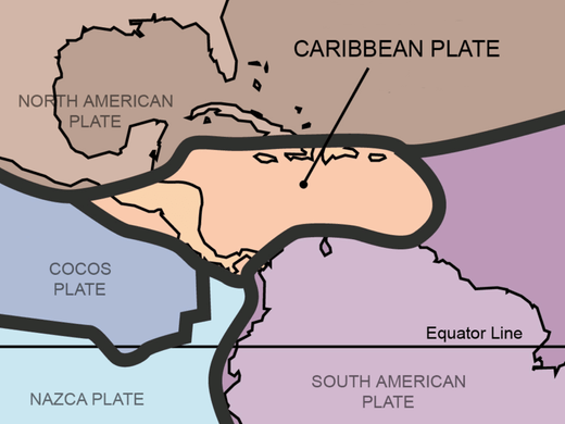
Map depicting the Caribbean plate boundaries.
Southern Boundary: Transpressional Deformation
The southern boundary presents the most complex structural zone, where the Caribbean Plate interacts with the South American Plate through a combination of transform faulting, thrust faulting, and oblique convergence. This boundary extends from the mouth of the Orinoco River in Venezuela westward to the Colombian coast.
The El Pilar Fault system in northern Venezuela represents the primary transform structure, accommodating eastward motion of the Caribbean through right-lateral strike-slip motion. However, the boundary also includes significant thrust components, creating the Cordillera de la Costa and other mountain ranges in northern Venezuela.
Offshore, the boundary becomes increasingly complex, involving the accretion of Caribbean oceanic crust to the South American continental margin. This process uplifted Barbados and created the Barbados Ridge, demonstrating active continental growth through tectonic accretion.
The southern boundary zone experiences regular seismic activity, including the 1967 Caracas earthquake (M 6.9) and numerous smaller events. The complex stress field results from the oblique convergence between the Caribbean and South American plates, creating both thrust and strike-slip focal mechanisms.
Western Boundary: Central American Subduction
The western boundary involves the subduction of the Cocos Plate beneath the Caribbean Plate along the Middle America Trench. This eastward-dipping subduction zone extends from southern Mexico to northern Panama, accommodating convergence rates of 70-90 millimeters (2.8-3.5 inches) per year.
The rapid subduction creates the Central America Volcanic Arc, featuring over 60 major volcanic centers across Guatemala, El Salvador, Honduras, Nicaragua, and Costa Rica. Active volcanoes include Arenal and Poás in Costa Rica, Masaya and Momotombo in Nicaragua, and Santa Ana in El Salvador.
The Central American arc exhibits typical oceanic-continental subduction characteristics, characterized by predominantly andesitic volcanism and frequent explosive eruptions. The high convergence rate and young age of the subducting Cocos Plate create particularly vigorous volcanic activity and significant seismic hazards.
The 2001 El Salvador earthquakes (M 7.7 and M 6.6) demonstrate the seismic risks associated with this subduction zone. The shallow depth of many earthquakes, combined with high population density, creates significant hazard exposure for Central American populations.
Microplate Systems and Internal Deformation
The Caribbean Plate contains several microplates and blocks that accommodate internal deformation through distributed faulting and local rotation. The Gonâve Microplate, located between Haiti and Jamaica, represents the best-studied example, bounded by the Septentrional Fault to the north and the Enriquillo-Plantain Garden Fault to the south.
The devastating 2010 Haiti earthquake (M 7.0) occurred along the Enriquillo-Plantain Garden Fault system, demonstrating the continuing activity of these internal boundaries. The quake killed over 200,000 people and highlighted the vulnerability of Caribbean populations to seismic hazards.
Other internal structures include the Oriente Fault in Cuba, the Muertos Trough south of Puerto Rico and Hispaniola, as well as various fault systems throughout the Greater Antilles. These features accommodate the complex stress fields generated by the motion of the Caribbean Plate relative to its neighbors.
Geological Resources and Economic Impact
Caribbean Plate tectonics created significant natural resources, particularly in the Greater Antilles, where complex geological processes concentrated minerals and hydrocarbons. Jamaica contains major bauxite deposits associated with karst weathering of limestone terranes. Cuba hosts important nickel laterite deposits formed through tropical weathering of ultramafic rocks.
The volcanic activity associated with subduction zones offers significant geothermal energy potential, particularly in Central America, where several countries derive a substantial portion of their electricity from geothermal sources. Costa Rica generates over 10% of its electricity from geothermal power, primarily from volcanic areas created by the subduction of the Cocos Plate.
However, the same tectonic processes that create resources also generate natural hazards. Volcanic eruptions, earthquakes, and tsunamis continue to pose significant risks to Caribbean populations. The region's economic development must account for these geological realities by implementing appropriate hazard mitigation and building codes.
Biodiversity and Environmental Connections
The complex topography created by Caribbean Plate tectonics supports exceptional biodiversity, particularly in the Greater Antilles, where mountain building created diverse elevation gradients and isolated habitats. Endemic species such as the Solenodon paradoxus (Hispaniolan solenodon) evolved in the unique environments created by tectonic uplift and volcanic activity.
Coral reef ecosystems throughout the Caribbean benefit from the warm, clear waters maintained by the region's tropical climate and oceanic circulation patterns, which are influenced by plate tectonic activity. However, volcanic activity and seismic events periodically impact these ecosystems, demonstrating the ongoing interaction between geological and biological processes.
The Caribbean Plate exemplifies how intermediate-sized oceanic plates can exhibit extraordinary tectonic complexity through interactions with multiple larger plates. Its continuing evolution influences geological processes, natural hazards, and environmental conditions throughout one of the world's most geographically and culturally diverse regions.
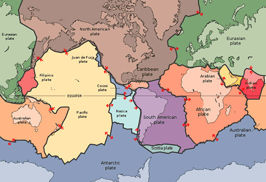
Map depicting the major tectonic plates of the world.