Puerto Rico's Mountain Ranges: Exploring the Rugged Backbone of the Caribbean
Puerto Rico's landscape rises from coastal plains to peaks, creating diverse topography despite its compact size. The mountainous interior, "La Cordillera Central," forms the geological backbone of the archipelago, hosting unique ecosystems and serving as the watershed for vital freshwater resources.


Peaks and Valleys: The Geological Heritage of Puerto Rico's Mountains
Puerto Rico's landscape rises dramatically from coastal plains to towering peaks, creating a topographical diversity that belies the island's compact size. The mountainous interior, locally known as "La Cordillera Central," forms the geological backbone of this Caribbean archipelago, hosting ecosystems found nowhere else on Earth and serving as the watershed for the island's vital freshwater resources. These ancient formations, sculpted by millions of years of volcanic activity and erosion, continue to shape the climate, culture, and economy of Puerto Rico.
The Cordillera Central: Puerto Rico's Mountain Spine
The Cordillera Central dominates Puerto Rico's interior, stretching approximately 64 km (40 mi) from east to west across the island's midsection. This mountain range represents the remnants of ancient volcanic activity and subsequent geological processes that began forming during the Late Cretaceous period, roughly 100 million years ago.
The range reaches its highest elevation at Cerro de Punta, which stands at 1,338 m (4,390 ft) above sea level. Located in the municipality of Ponce, near the town of Jayuya, Cerro de Punta serves as Puerto Rico's highest point and offers panoramic views of both the Caribbean Sea and Atlantic Ocean on clear days. The peak sits within the boundaries of Toro Negro State Forest, part of Puerto Rico's protected forest system.
Adjacent to Cerro de Punta, several other significant peaks define the Cordillera Central's skyline. Cerro Rosa, at 1,267 m (4,157 ft), and Monte Jayuya, at 1,315 m (4,314 ft), form a cluster of high-elevation terrain that influences weather patterns across the entire island. These mountains intercept moisture-laden trade winds, creating orographic precipitation that feeds numerous rivers and streams flowing toward both coasts.
Sierra de Luquillo: The Northeastern Highlands
The Sierra de Luquillo, located in northeastern Puerto Rico, forms a distinct mountain system separate from the Cordillera Central. This range encompasses the famous El Yunque National Forest, the only tropical rainforest in the United States National Forest System. The Sierra extends approximately 32 km (20 mi) from east to west and reaches elevations exceeding 1,000 m (3,281 ft).
El Yunque Peak, the range's highest point at 1,065 m (3,494 ft), towers above one of the most biodiverse ecosystems in the Caribbean. The mountain's name derives from the Taíno word "yukiyu," meaning "white lands," referring to the frequent cloud cover that shrouds the upper elevations. The Sierra de Luquillo receives some of the highest annual rainfall in Puerto Rico, with specific areas recording over 5,000 mm (197 in) annually.
The geological composition of the Sierra de Luquillo differs significantly from the Cordillera Central. These mountains consist primarily of volcanic rocks from the Late Cretaceous and Paleocene periods, including andesites, dacites, and volcanic breccias. The combination of high rainfall, warm temperatures, and ancient volcanic soils creates ideal conditions for the lush tropical vegetation that characterizes El Yunque National Forest.
The Sierra de Cayey: Eastern Mountain Extension
South of the Sierra de Luquillo, the Sierra de Cayey extends the mountainous terrain toward the island's eastern regions. This range, while lower in elevation than the Cordillera Central, plays a crucial role in the island's hydrology and ecosystem diversity. The Sierra de Cayey includes several peaks exceeding 800 m (2,625 ft), with Cerro La Santa reaching 903 m (2,963 ft).
The towns of Cayey, Cidra, and Caguas nestle within the valleys and foothills of this range, benefiting from the cooler temperatures and abundant freshwater resources. The Sierra de Cayey serves as a watershed for several important rivers, including the Río Grande de Loíza, Puerto Rico's longest river, which flows northward to the Atlantic Ocean.
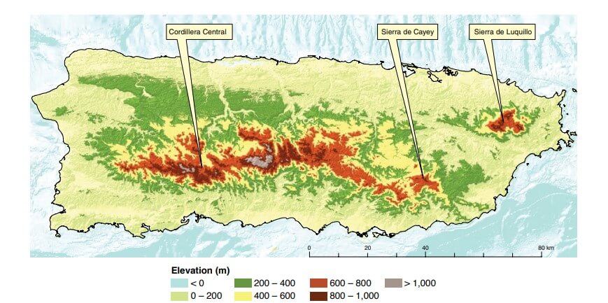
A topographic map of Puerto Rico shows Cordillera Central and its major subranges.
Geological Formation and Structure
Puerto Rico's mountain ranges originated from complex geological processes spanning millions of years. The island is situated on the tectonic boundary between the North American Plate and the Caribbean Plate, resulting in significant seismic and volcanic activity throughout its geological history. The mountains consist primarily of volcanic rocks, limestone formations, and igneous intrusions that have been shaped by erosion, weathering, and tectonic forces.
The volcanic rocks that form the mountain cores date primarily to the Late Cretaceous period, when extensive volcanic activity created the foundation for Puerto Rico's current topography. Subsequent periods of uplift, erosion, and limestone deposition during the Tertiary period created the diverse geological landscape visible today. The presence of limestone karst formations, particularly in the northern foothills and coastal areas, demonstrates the complex interplay between volcanic and sedimentary processes.
Climate and Weather Patterns
The mountain ranges of Puerto Rico create distinct microclimates that vary dramatically with elevation and orientation. The windward slopes, facing the prevailing trade winds from the northeast, receive significantly more precipitation than the leeward slopes. The Sierra de Luquillo exemplifies this pattern, with the northeastern slopes receiving over 4,000 mm (157 in) of annual rainfall while the southwestern slopes may receive less than 1,500 mm (59 in).
Temperature decreases predictably with elevation, following the environmental lapse rate of approximately 6.5°C per 1,000 m (3.5°F per 1,000 ft). At sea level, Puerto Rico maintains average temperatures between 24-28°C (75-82°F) year-round, while the highest peaks experience temperatures 8-10°C (14-18°F) cooler. This temperature gradient creates distinct vegetation zones, from tropical dry forests at lower elevations to cloud forests at the highest peaks.
Biodiversity and Ecosystems
Puerto Rico's mountains harbor extraordinary biodiversity within a relatively small geographic area. The elevation gradients create multiple ecological zones, each supporting distinct plant and animal communities. The El Yunque National Forest alone contains over 240 tree species, including 23 endemic species found nowhere else on Earth.
The tabonuco forest dominates elevations between 150-600 m (492-1,969 ft), characterized by large tabonuco trees that can reach heights of 35 m (115 ft). Above 600 m (1,969 ft), the Palo Colorado forest takes over, featuring shorter trees adapted to higher elevation conditions and frequent cloud cover. At the highest elevations, above 900 m (2,953 ft), the elfin woodland, also known as a cloud forest, creates a unique ecosystem where trees rarely exceed 5 m (16 ft) in height due to constant wind exposure and frequent cloud immersion.
The mountainous regions provide habitat for several endemic and endangered species. The Puerto Rican parrot, one of the world's most endangered birds, depends on the mountain forests for survival. The coquí, Puerto Rico's beloved endemic frog, reaches its highest diversity in the mountain forests, with several species found only at specific elevation ranges.
Hydrology and Water Resources
The mountain ranges serve as Puerto Rico's primary watershed, collecting rainfall and feeding the rivers that supply freshwater to the island's 3.2 million residents. The high-elevation areas receive the majority of the island's precipitation, which then flows through an extensive network of streams and rivers toward both the Atlantic and Caribbean coasts.
Major rivers originating in the Cordillera Central include the Río Grande de Arecibo, flowing northward to the Atlantic, and the Río Portuguesa, flowing southward to the Caribbean Sea. The Sierra de Luquillo feeds several smaller but important rivers, including the Río Mameyes and Río Blanco. These freshwater resources support both urban populations and agricultural activities in the coastal plains.
The mountains' role in water collection becomes particularly critical during the dry season, typically from December through April, when rainfall decreases significantly in the lower elevations. The higher elevations continue to receive moisture from trade wind clouds, maintaining stream flow and groundwater recharge throughout the year.
Human Settlement and Cultural Significance
The mountain regions of Puerto Rico have supported human habitation for over 1,000 years. The Indigenous Taíno people established settlements in the mountain valleys, capitalizing on the fertile soils, abundant freshwater, and favorable climate for agriculture. Spanish colonization introduced coffee cultivation to the mountains, transforming the landscape and economy of the interior regions.
Today, several municipalities have developed within the mountain ranges, including Cayey, Cidra, Caguas, and Comerío. These communities benefit from cooler temperatures, making them popular destinations for residents seeking relief from the coastal heat. The town of Adjuntas, located at approximately 550 m (1,804 ft) elevation, markets itself as "La Ciudad del Gigante Dormido" (The City of the Sleeping Giant) due to its location within the Cordillera Central.
Coffee production remains an important economic activity in the mountains, with farms scattered throughout the higher elevations taking advantage of the ideal growing conditions. The combination of altitude, temperature, and rainfall creates perfect conditions for high-quality arabica coffee production, contributing to Puerto Rico's reputation for premium coffee.
Recreation and Tourism
Puerto Rico's mountains offer numerous recreational opportunities, attracting both residents and international visitors. El Yunque National Forest receives over 1 million visitors annually, making it one of the most visited destinations in Puerto Rico. The forest offers hiking trails ranging from easy walks to challenging climbs, including the popular trail to El Yunque Peak.
The Cordillera Central provides opportunities for more adventurous activities, including hiking to Cerro de Punta and exploring the Toro Negro State Forest. The cooler mountain climate makes these areas particularly attractive during the warmer months, offering a refreshing alternative to the coastal regions.
Mountain biking, birdwatching, and nature photography have become increasingly popular activities in the mountain regions. The diverse ecosystems and scenic vistas provide excellent opportunities for eco-tourism, contributing to the local economy while promoting conservation awareness.
Conservation Challenges and Efforts
The mountain ecosystems of Puerto Rico face numerous conservation challenges, including habitat fragmentation, invasive species, and the impacts of climate change. Urban development pressure from growing populations in mountain communities threatens natural habitats, while agricultural expansion continues to convert forest land to other uses.
Hurricane impacts pose significant challenges to mountain forest ecosystems. Hurricane Hugo in 1989 and Hurricane María in 2017 caused extensive damage to El Yunque National Forest, requiring years of recovery and restoration efforts. The 2017 hurricane stripped vegetation from mountainsides and altered stream channels, demonstrating the vulnerability of these ecosystems to extreme weather events.
Conservation efforts include the establishment of protected areas, reforestation programs, and research initiatives aimed at enhancing our understanding of mountain ecosystem dynamics. The Puerto Rico Department of Natural and Environmental Resources manages several state forests within the mountain ranges, while federal agencies oversee El Yunque National Forest and other protected areas.
Economic Importance
The mountain ranges significantly contribute to Puerto Rico's economy across multiple sectors. Tourism generated by mountain attractions brings millions of dollars annually to local communities. The watershed services provided by mountain forests support agriculture, urban water supplies, and hydroelectric power generation.
Agricultural production in the mountains includes not only coffee but also plantains, citrus fruits, and vegetables that benefit from the cooler temperatures and abundant rainfall. The fertile volcanic soils and favorable growing conditions support both subsistence farming and commercial agriculture.
The pharmaceutical industry has established facilities in some mountain communities, capitalizing on the cooler climate for temperature-sensitive manufacturing processes. The town of Cidra, situated in the Cordillera Central, is home to several pharmaceutical manufacturing facilities that benefit from the stable mountain climate.
Summary
Puerto Rico's mountain ranges represent far more than geological formations; they constitute the ecological, hydrological, and cultural heart of the island. The Cordillera Central, Sierra de Luquillo, and Sierra de Cayey create a diverse landscape that supports unique ecosystems, provides essential freshwater resources, and shapes the climate patterns across the entire archipelago. From the cloud forests of El Yunque to the coffee farms of the Cordillera Central, these mountains continue to play vital roles in Puerto Rico's environmental and economic well-being.
The remarkable biodiversity found within these relatively small mountain systems includes numerous endemic species that exist nowhere else on Earth, highlighting the global conservation significance of Puerto Rico's mountains. The complex geological history, spanning millions of years of volcanic activity and erosion, has created landscapes of extraordinary beauty and ecological importance.
As Puerto Rico faces challenges from climate change, population growth, and economic development, the conservation and sustainable management of these mountain ranges becomes increasingly critical. The mountains' role as watersheds, biodiversity refuges, and cultural landscapes ensures their continued importance for future generations of Puerto Ricans and the global scientific community.