The North American Plate: Continental Giant of the Northern Americas
The North American Plate, a massive tectonic entity, is Earth's second-largest tectonic plate. Underlying substantial portions of North America and Central America and even reaching into the Caribbean Sea, its dynamics shape the region's geological features, fostering a complex landscape.
 - by CrazyKnight, CC BY-SA 3.0, via Wikimedia Commons")
Continental Foundation: How the North American Plate Shapes Two Continents
The North American Plate, Earth's second-largest tectonic plate covering approximately 76 million square kilometers (29.3 million square miles), underlies most of North America, Greenland, the western Atlantic Ocean, and portions of the Caribbean Sea. This massive continental plate illustrates the intricate interactions between continental and oceanic lithosphere, driving a range of diverse geological processes from the Arctic Ocean to Central America.
Geological Structure and Composition
The North American Plate exhibits extraordinary geological diversity, combining ancient continental crust over 4 billion years old with recently formed oceanic crust. The continental portion includes the Canadian Shield, one of Earth's oldest geological formations, and younger mountain belts, including the Appalachians and western Cordillera.
The thickness of the continental crust varies dramatically across the plate, reaching 70 kilometers (43 miles) beneath the Rocky Mountains, while thinning to 25 kilometers (15 miles) along passive continental margins. The oceanic portion averages 6-8 kilometers (3.7-5.0 miles) thick, typical of oceanic crust worldwide.
The plate's complex history encompasses multiple episodes of continental collision, rifting, and accretion, which have created North America's diverse geological provinces. The Superior Province of the Canadian Shield preserves rocks formed during Earth's early history, while ongoing processes continue to shape the plate's western margin.
Eastern Boundary: The Mid-Atlantic Ridge System
The eastern boundary of the North American Plate follows the Mid-Atlantic Ridge, a divergent plate boundary where new oceanic crust is formed through seafloor spreading. This boundary extends over 10,000 kilometers (6,200 miles) from the Arctic Ocean to the South Atlantic, representing one of the world's longest spreading systems.
Spreading rates along the ridge average 25-30 millimeters (1.0-1.2 inches) per year, which is intermediate between the slow and fast spreading rates observed globally. The process creates a continuous mountain range beneath the Atlantic Ocean, periodically emerging as volcanic islands, including Iceland and the Azores.
The ridge system comprises numerous transform faults that offset spreading segments, resulting in fracture zones that extend across the Atlantic Basin. The Charlie-Gibbs Fracture Zone represents one of the most prominent features, influencing oceanic circulation and biological distributions across the North Atlantic.
Western Boundary: Pacific Interactions
The plate's western boundary creates one of Earth's most complex tectonic zones through interactions with the Pacific Plate and smaller oceanic plates. This boundary extends from Alaska's Aleutian Trench to the Gulf of California, exhibiting a diverse range of boundary types and geological processes.
In Alaska, the Pacific Plate subducts beneath the North American Plate along the Aleutian Trench, generating intense volcanic activity and frequent large earthquakes. The Aleutian volcanic arc contains over 50 active volcanoes and represents one of the most seismically active regions globally.
The transform portion includes the famous San Andreas Fault system, extending through California from the Salton Sea to Cape Mendocino. This fault system accommodates approximately 50 millimeters (2.0 inches) per year of relative motion between the Pacific and North American plates, generating frequent earthquakes and ongoing landscape modification.
The Gulf of California represents an active rifting zone, where the Baja California Peninsula separates from the mainland of Mexico. This process began approximately 6 million years ago and continues today, with spreading rates of 50-60 millimeters (2.0-2.4 inches) per year creating new oceanic crust.
Southern Boundary: Caribbean Complexity
The southern boundary involves complex interactions with the Caribbean Plate across Central America and the northern Caribbean. This boundary zone accommodates the relative motion between the large North American Plate and the smaller Caribbean Plate through diverse fault systems.
The Motagua Fault in Guatemala represents the primary onshore boundary, generating significant seismic activity, including the devastating 1976 Guatemala earthquake (M 7.5). This fault accommodates left-lateral strike-slip motion as the Caribbean Plate moves eastward relative to North America.
Offshore boundaries include the Swan Islands Transform Fault beneath the Caribbean Sea and complex interactions along the Cayman Trough. These features accommodate the eastward motion of the Caribbean Plate while generating frequent seismic activity throughout the region.
The complexity of the boundary zone reflects the oblique convergence between the North American and Caribbean plates, resulting in both transform and thrust faulting components that influence geological processes throughout Central America and the Caribbean.
Northern Boundary: Arctic Ocean Dynamics
The northern boundary extends across the Arctic Ocean, where the North American Plate meets the Eurasian Plate along the Gakkel Ridge, the northernmost portion of the global mid-ocean ridge system. This ultra-slow spreading ridge accommodates separation rates of only 12-13 millimeters (0.5 inches) per year.
The Arctic boundary exhibits unique characteristics due to its location beneath permanent sea ice and the extreme environmental conditions it faces. Volcanic activity along the Gakkel Ridge occurs beneath thick ice cover, creating distinctive geological features and supporting unique ecosystems around hydrothermal vents.
Recent discoveries of explosive volcanism along the Gakkel Ridge challenge previous assumptions about volcanic processes under thick ice cover. These findings underscore the significant gaps in knowledge about geological processes in Earth's most remote regions.
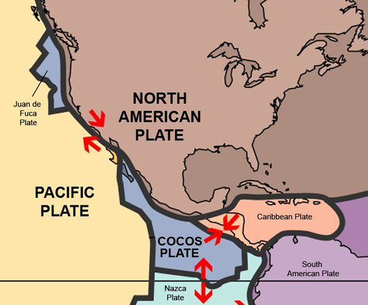
Map depicting the North American plate boundaries.
Internal Structure: Cratonic Stability and Active Margins
The interior of the North American Plate contains the stable North American Craton, surrounded by younger, mobile belts and active margins. The Canadian Shield forms the exposed core of the craton, containing some of Earth's oldest rocks and providing a stable platform for the continent's geological evolution.
Surrounding mobile belts include the Appalachian Mountains in the east, formed through ancient continental collisions, and the western Cordillera, created by ongoing convergent processes. These contrasting geological provinces demonstrate how plate tectonics creates diverse landscapes within single plates.
The plate's interior experiences relatively low seismic activity compared to its active margins, though significant earthquakes occasionally occur. The 1811-1812 New Madrid earthquakes in the central United States demonstrate that even stable continental interiors can generate major seismic events through reactivation of ancient fault systems.
Geological Resources and Economic Significance
The North American Plate contains extraordinary mineral and energy resources formed over billions of years through geological processes. The Canadian Shield is home to world-class deposits of gold, nickel, copper, and rare metals, formed through ancient volcanic and hydrothermal processes.
Sedimentary basins throughout the plate contain vast petroleum and natural gas reserves, including the Permian Basin of Texas, the Bakken Formation of North Dakota, and the oil sands of Alberta. These resources formed through complex interactions between tectonics, climate, and biological processes over geological time.
Coal deposits throughout the Appalachian and western basins powered industrial development, while diverse metallic ore deposits supported mining industries across North America. The plate's geological diversity creates resource endowments that fundamentally shaped economic development patterns.
Seismic Activity and Natural Hazards
Despite containing large stable areas, the North American Plate experiences significant seismic activity along its active margins and occasionally within its interior. The San Andreas Fault system poses significant earthquake hazards to California's population, with the potential for magnitude eight or greater earthquakes along several segments.
The Cascadia Subduction Zone, located off the Pacific Northwest coast, represents another major seismic hazard, capable of generating magnitude 9+ earthquakes and associated tsunamis. Geological evidence suggests that this zone has experienced several significant earthquakes within the past 3,000 years.
Alaska experiences frequent large earthquakes associated with the subduction of the Pacific Plate, including the 1964 Good Friday earthquake (M 9.2), the second-largest earthquake ever recorded. This event highlights the potential for significant earthquakes along the convergent boundaries of the North American Plate.
Climate and Environmental Interactions
The vast size and diverse topography of the North American Plate significantly influence regional and global climate patterns. The Rocky Mountains create a significant barrier to atmospheric circulation, resulting in distinct climate zones and precipitation patterns across the continent.
Glacial processes associated with Pleistocene ice ages extensively modified the plate's northern regions, creating the Great Lakes, carving major river valleys, and depositing thick sedimentary sequences. These processes demonstrate how climate changes interact with geological structures over long time scales.
Current climate change effects include accelerated glacial melting in Alaska and northern Canada, which may influence regional tectonics through isostatic adjustment as ice loads decrease. These processes illustrate continuing interactions between climate and geological systems.
Biological and Ecological Connections
The geological diversity created by North American Plate tectonics supports an extraordinary level of biological diversity across multiple biomes. Ancient mountain-building events created isolated highlands that fostered the evolution of endemic species, while river systems and coastal areas provided diverse aquatic habitats.
Endemic species, such as Sequoiadendron giganteum (giant sequoia), occur in specific geological settings created by plate tectonic processes. These ancient trees grow only in particular soil and climate conditions associated with the Sierra Nevada geology and tectonics.
The plate's geological processes continue influencing ecosystem distribution and evolution. Ongoing mountain building, erosion, and sedimentation create new habitats while modifying existing ones, demonstrating the continuing interaction between geological and biological processes.
The North American Plate exemplifies how large continental plates integrate diverse geological processes across vast areas and long time scales. Its complex evolution and continuing activity influence everything from global climate patterns to regional economic development, making it one of the most significant tectonic entities in understanding Earth system interactions.
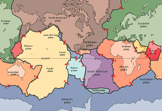
Map depicting the major tectonic plates in the world.