Brazil's Comprehensive Aquatic Landscape: From the Amazon to the Atlantic
Brazil is defined by water. The Amazon River system flows through its heart, and the vast Atlantic coastline borders the east. Water shapes the geography, ecology, economy, and culture of South America's largest country, supporting human civilization and biodiversity.


 - by ORTENCIA / (CC BY-SA 4.0) via Wikimedia Commons")


Rivers, Lakes, and Coasts: The Aquatic Treasures of Brazil
Brazil stands as a nation defined by water. From the mighty Amazon River system that courses through its heart to the extensive Atlantic coastline that borders its eastern edge, water shapes the geography, ecology, economy, and culture of South America's largest country. Covering 8.5 million km² (3.3 million mi²), Brazil contains approximately 12% of the world's freshwater resources, making it one of the most water-rich nations on Earth. The country's hydrological wealth encompasses vast river systems, numerous lakes, expansive wetlands, and over 7,400 km (4,600 mi) of coastline, creating a diverse aquatic landscape that supports both human civilization and extraordinary biodiversity.
The Amazon Basin: Heart of South America's Waters
The Amazon River System
The Amazon River system represents the crown jewel of Brazil's water resources. Originating in the Peruvian Andes and flowing eastward across the continent, the Amazon River stretches approximately 6,400 km (4,000 mi), making it the longest river in the world. Within Brazilian territory, the river spans roughly 3,200 km (2,000 mi) before emptying into the Atlantic Ocean through a massive delta system.
The Amazon's discharge volume is staggering, releasing an average of 209,000 m³/s (7.4 million ft³/s) of water into the Atlantic Ocean. During peak flood season, the discharge can exceed 300,000 m³/s (10.6 million ft³/s), representing nearly 20% of all freshwater entering the world's oceans. The river's width varies dramatically along its course, ranging from 1.6 km (1 mi) during the dry season to over 48 km (30 mi) during flood periods in some areas.
Major Amazon Tributaries
The Amazon's tributary network creates an intricate web of waterways throughout northern Brazil. The Rio Negro, the largest tributary by volume, contributes approximately 28,000 m³/s (990,000 ft³/s) to the main stem. Its dark, acidic waters create the famous "Meeting of Waters" phenomenon near Manaus, where they flow alongside the muddy Amazon for several kilometers without mixing.
The Tapajós River, flowing northward from the Brazilian Highlands, adds another 13,500 m³/s (477,000 ft³/s) to the system. The Xingu River, known for its clear waters and Indigenous territories, contributes 9,700 m³/s (342,000 ft³/s). Other significant tributaries include the Madeira River, which alone drains an area larger than France, and the Tocantins River, which is technically separate from the Amazon system but shares its delta region.
The Paraná River System: Southeastern Brazil's Lifeline
The Paraná River
The Paraná River system dominates southeastern Brazil's hydrology, serving as a crucial waterway for the country's most economically developed regions. The Paraná itself flows 4,880 km (3,030 mi) from its source in Brazil to its mouth in Argentina, with approximately 1,550 km (960 mi) of its length within Brazilian territory. The river's average discharge of 17,500 m³/s (618,000 ft³/s) makes it the second-largest river system in South America.
The Iguazu Falls and Tributaries
Among the Paraná's most spectacular features are the Iguazu Falls, located on the border between Brazil and Argentina. These falls consist of 275 individual cascades spanning 2.7 km (1.7 mi) in width, with the tallest drop reaching 82 m (269 ft). The falls result from a geological fault where the Iguazu River, a tributary of the Paraná, plunges over a basaltic plateau.
The Paraguay River, another major tributary, flows 2,620 km (1,630 mi) from its source in Brazil's Mato Grosso state to its confluence with the Paraná. The river's floodplain forms the Pantanal, one of the world's most extensive tropical wetlands, spanning approximately 150,000 km² (58,000 mi²) across Brazil, Bolivia, and Paraguay.
São Francisco River: The River of National Unity
The São Francisco River holds special significance in Brazilian history and culture, earning the nickname "Rio da Integração Nacional" (River of National Unity). Flowing entirely within Brazilian territory, the river extends 2,814 km (1,749 mi) from its source in Minas Gerais to its mouth between Alagoas and Sergipe states.
The river's watershed covers 641,000 km² (247,000 mi²), encompassing portions of seven Brazilian states. Its average discharge of 2,850 m³/s (101,000 ft³/s) supports approximately 14 million people living within its basin. The São Francisco's most famous feature is the Paulo Afonso Falls, a series of cascades totaling 80 m (262 ft) in height that has been harnessed for hydroelectric power generation.
Atlantic Coastal Waters and Lagoons
Coastal Lagoons
Brazil's Atlantic coast is characterized by numerous coastal lagoons, particularly in the southern states. The Lagoa dos Patos in Rio Grande do Sul represents the largest coastal lagoon in Brazil and the second-largest in South America, covering 10,360 km² (4,000 mi²). This shallow lagoon, with an average depth of 5 m (16 ft), connects to the Atlantic Ocean through a single outlet near the city of Rio Grande.
The Lagoa Mirim, shared between Brazil and Uruguay, covers 3,750 km² (1,450 mi²) and serves as an important fishery and transportation route. Further north, the Lagoa Rodrigo de Freitas in Rio de Janeiro, though much smaller at 2.3 km² (0.9 mi²), holds cultural significance as an iconic feature of the city's landscape.
Coastal Rivers
Numerous shorter rivers drain directly into the Atlantic Ocean along Brazil's extensive coastline. The Paraíba do Sul River flows 1,137 km (706 mi) through the states of São Paulo, Minas Gerais, and Rio de Janeiro, draining a heavily industrialized watershed of 57,000 km² (22,000 mi²). The Doce River, extending 853 km (530 mi), historically served as a major transportation route connecting the interior mining regions to the coast.
Artificial Lakes and Reservoirs
Brazil's extensive hydroelectric development has created numerous artificial lakes and reservoirs throughout the country. The Sobradinho Reservoir on the São Francisco River covers 4,214 km² (1,627 mi²), making it one of the largest artificial lakes in the world by surface area. The Balbina Reservoir in Amazonas state, despite covering 4,437 km² (1,713 mi²), has been a subject of controversy due to its low power generation relative to its environmental impact.
The Itaipu Reservoir, created by the famous Itaipu Dam on the Paraná River, covers 1,350 km² (521 mi²) and represents one of the world's most productive hydroelectric facilities. These artificial water bodies have significantly altered regional hydrology while providing essential electricity generation and water storage capacity.
Wetlands and Unique Aquatic Ecosystems
The Pantanal
The Pantanal wetlands represent one of Brazil's most distinctive aquatic ecosystems. Covering approximately 150,000 km² (58,000 mi²) within Brazil alone, the Pantanal experiences dramatic seasonal flooding that transforms vast areas between terrestrial and aquatic environments. During peak flood season, up to 80% of the region may be underwater, creating a dynamic ecosystem that supports exceptional biodiversity.
Cerrado Wetlands
The Cerrado savanna contains numerous seasonal wetlands and gallery forests along its waterways. These areas serve as crucial water sources during dry seasons and support specialized plant and animal communities adapted to alternating wet and dry conditions. The headwaters of major river systems, including the Amazon, Paraná, and São Francisco, originate within the Cerrado biome.
Groundwater Resources
Brazil possesses substantial groundwater reserves, with the Guarani Aquifer representing one of the world's largest freshwater aquifer systems. Extending beneath 1.2 million km² (463,000 mi²) across Brazil, Argentina, Paraguay, and Uruguay, the aquifer contains an estimated 45,000 km³ (10,800 mi³) of water. Within Brazil, the aquifer covers approximately 840,000 km² (324,000 mi²), providing water supply for over 15 million people.
The Alter do Chão Aquifer, located beneath the Amazon Basin, potentially contains even larger volumes of freshwater, though its characteristics remain less well-studied than the Guarani system. These groundwater resources represent crucial reserves for future water security, particularly in regions experiencing an increase in drought frequency.
Water Quality and Environmental Challenges
Brazil's water bodies face increasing pressure from industrial pollution, agricultural runoff, and urban development. The Tietê River in São Paulo state exemplifies these challenges, as it flows through one of South America's largest metropolitan areas and receives substantial pollution loads despite ongoing cleanup efforts.
Deforestation in the Amazon Basin threatens the hydrological cycle that maintains the region's precipitation patterns. Scientists estimate that the Amazon rainforest generates approximately 50% of its own rainfall through evapotranspiration, making forest conservation critical for maintaining water resources throughout the basin.
Mining activities, particularly in the Amazon and southeastern regions, have introduced heavy metals and sediments into river systems. The 2015 Mariana dam disaster and the 2019 Brumadinho dam collapse highlighted the vulnerability of water resources to industrial accidents, affecting hundreds of kilometers of river systems.
Economic and Social Importance
Brazil's water resources support a diverse range of economic activities, including hydroelectric power generation, commercial fishing, and transportation. The Amazon River system serves as a highway for communities and commerce throughout the northern regions, with cargo vessels navigating over 3,000 km (1,900 mi) upstream from the Atlantic Ocean.
Hydroelectric power provides approximately 65% of Brazil's electricity generation, with major facilities located on the São Francisco, Paraná, and Amazon river systems. The country's hydroelectric capacity exceeds 100,000 MW, representing one of the world's largest renewable energy portfolios.
Commercial and subsistence fishing depend heavily on both river systems and coastal waters. The Amazon Basin alone supports over 3,000 fish species, many of which are economically important for local communities. Coastal fisheries contribute significantly to protein supply and export revenues.
Summary
Brazil's water resources represent an extraordinary natural endowment that shapes the country's geography, ecology, and human development. The Amazon River system stands as the world's largest river network, carrying nearly one-fifth of all freshwater entering the oceans while supporting unparalleled biodiversity. The Paraná River system serves as the economic backbone of southeastern Brazil, providing hydroelectric power, transportation, and water supply for the nation's most populous regions.
The São Francisco River connects Brazil's interior to its coast, earning recognition as a unifying national symbol while supporting millions of inhabitants along its course. Extensive coastal lagoons, artificial reservoirs, and unique wetland systems like the Pantanal add further diversity to Brazil's aquatic landscape. Substantial groundwater reserves, including the massive Guarani Aquifer, provide additional water security for current and future generations.
However, these water resources face mounting pressures from pollution, deforestation, climate change, and intensive development. Protecting and sustainably managing Brazil's water wealth remains essential for maintaining the country's ecological integrity, economic prosperity, and social well-being. The stewardship of these aquatic treasures will determine not only Brazil's future but also influence global water cycles and climate patterns that affect the entire planet.
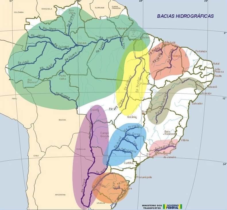
Map illustrating the watersheds of Brazil.
Significant Water Bodies of Brazil
Major Rivers
Amazon River (Rio Amazonas)
- Length: 6,400 km (4,000 mi) total; 3,200 km (2,000 mi) within Brazil
- Drainage basin: 7 million km² (2.7 million mi²) total; 3.8 million km² (1.5 million mi²) within Brazil
- Average discharge: 209,000 m³/s (7.4 million ft³/s)
- Location: Flows east across northern Brazil from the Peru border to the Atlantic Ocean
Rio Negro
- Length: 2,250 km (1,400 mi)
- Drainage basin: 691,000 km² (267,000 mi²)
- Average discharge: 28,000 m³/s (990,000 ft³/s)
- Location: Northern Brazil, flows southeast to join the Amazon near Manaus
Tapajós River
- Length: 1,992 km (1,238 mi)
- Drainage basin: 490,000 km² (189,000 mi²)
- Average discharge: 13,500 m³/s (477,000 ft³/s)
- Location: North-central Brazil, flows north from Mato Grosso to the Amazon River
Xingu River
- Length: 1,979 km (1,230 mi)
- Drainage basin: 509,000 km² (196,000 mi²)
- Average discharge: 9,700 m³/s (342,000 ft³/s)
- Location: Central Brazil, flows north from Mato Grosso through Pará to the Amazon
Madeira River
- Length: 3,250 km (2,020 mi) total; 1,425 km (885 mi) within Brazil
- Drainage basin: 1.4 million km² (541,000 mi²)
- Average discharge: 31,200 m³/s (1.1 million ft³/s)
- Location: Western Brazil, flows northeast from the Bolivia border to the Amazon River
Tocantins River
- Length: 2,450 km (1,520 mi)
- Drainage basin: 767,000 km² (296,000 mi²)
- Average discharge: 13,598 m³/s (480,000 ft³/s)
- Location: Central Brazil, flows north from Goiás through Tocantins and Pará to the Atlantic
Paraná River
- Length: 4,880 km (3,030 mi) total; 1,550 km (960 mi) within Brazil
- Drainage basin: 2.6 million km² (1 million mi²) total; 879,000 km² (339,000 mi²) within Brazil
- Average discharge: 17,500 m³/s (618,000 ft³/s)
- Location: Southern Brazil, flows southwest through São Paulo, Paraná, and Mato Grosso do Sul
Paraguay River
- Length: 2,620 km (1,630 mi) total; 1,693 km (1,052 mi) within Brazil
- Drainage basin: 1.1 million km² (425,000 mi²)
- Average discharge: 4,300 m³/s (152,000 ft³/s)
- Location: Western Brazil, flows south through Mato Grosso and Mato Grosso do Sul
São Francisco River
- Length: 2,814 km (1,749 mi)
- Drainage basin: 641,000 km² (247,000 mi²)
- Average discharge: 2,850 m³/s (101,000 ft³/s)
- Location: Eastern Brazil, flows northeast from Minas Gerais through Bahia to the Atlantic between Alagoas and Sergipe
Paraíba do Sul River
- Length: 1,137 km (706 mi)
- Drainage basin: 57,000 km² (22,000 mi²)
- Average discharge: 820 m³/s (29,000 ft³/s)
- Location: Southeastern Brazil, flows through São Paulo, Minas Gerais, and Rio de Janeiro to the Atlantic
Doce River
- Length: 853 km (530 mi)
- Drainage basin: 83,400 km² (32,200 mi²)
- Average discharge: 850 m³/s (30,000 ft³/s)
- Location: Southeastern Brazil, flows from Minas Gerais through Espírito Santo to the Atlantic
Araguaia River
- Length: 2,627 km (1,632 mi)
- Drainage basin: 358,000 km² (138,000 mi²)
- Average discharge: 5,510 m³/s (195,000 ft³/s)
- Location: Central Brazil, flows north through Mato Grosso, Goiás, and Tocantins to join the Tocantins River
Major Lakes and Lagoons
Lagoa dos Patos
- Area: 10,360 km² (4,000 mi²)
- Average depth: 5 m (16 ft)
- Maximum depth: 7 m (23 ft)
- Location: Rio Grande do Sul, southern Brazil coast
Lagoa Mirim
- Area: 3,750 km² (1,450 mi²)
- Average depth: 2.5 m (8 ft)
- Location: Rio Grande do Sul, Brazil-Uruguay border
Lagoa Manguaba
- Area: 40 km² (15 mi²)
- Average depth: 1.5 m (5 ft)
- Location: Alagoas, northeastern Brazil coast
Lagoa Mundaú
- Area: 24 km² (9 mi²)
- Average depth: 1.8 m (6 ft)
- Location: Alagoas, northeastern Brazil coast
Lagoa Rodrigo de Freitas
- Area: 2.3 km² (0.9 mi²)
- Average depth: 2.8 m (9 ft)
- Location: Rio de Janeiro city center
Lagoa da Conceição
- Area: 20 km² (8 mi²)
- Average depth: 1.7 m (6 ft)
- Location: Florianópolis, Santa Catarina island
Lagoa Feia
- Area: 170 km² (66 mi²)
- Average depth: 1 m (3 ft)
- Location: Rio de Janeiro state, inland coastal plain
Major Reservoirs
Sobradinho Reservoir
- Area: 4,214 km² (1,627 mi²)
- Capacity: 34.1 billion m³ (27.6 million acre-ft)
- Location: São Francisco River, Bahia state
Balbina Reservoir
- Area: 4,437 km² (1,713 mi²)
- Capacity: 17.5 billion m³ (14.2 million acre-ft)
- Location: Uatumã River (Amazon basin), Amazonas state
Itaipu Reservoir
- Area: 1,350 km² (521 mi²)
- Capacity: 29 billion m³ (23.5 million acre-ft)
- Location: Paraná River, Brazil-Paraguay border
Tucuruí Reservoir
- Area: 2,430 km² (938 mi²)
- Capacity: 45.5 billion m³ (36.9 million acre-ft)
- Location: Tocantins River, Pará state
Três Marias Reservoir
- Area: 1,040 km² (402 mi²)
- Capacity: 21 billion m³ (17 million acre-ft)
- Location: São Francisco River, Minas Gerais state
Furnas Reservoir
- Area: 1,440 km² (556 mi²)
- Capacity: 22.9 billion m³ (18.6 million acre-ft)
- Location: Rio Grande, Minas Gerais state
Serra da Mesa Reservoir
- Area: 1,784 km² (689 mi²)
- Capacity: 54.4 billion m³ (44.1 million acre-ft)
- Location: Tocantins River, Goiás state
Wetland Systems
Pantanal
- Area: 150,000 km² (58,000 mi²) within Brazil; 195,000 km² (75,000 mi²) total
- Location: Paraguay River basin, primarily Mato Grosso and Mato Grosso do Sul states
- Seasonal variation: 80% flooded during the wet season, 20% during the dry season
Bananal Island
- Area: 19,162 km² (7,398 mi²) - the world's largest river island
- Location: Araguaia River, Tocantins state
- Wetland area: Approximately 50% seasonally flooded
Marajó Island
- Area: 40,100 km² (15,500 mi²)
- Location: Amazon River delta, Pará state
- Wetland coverage: 60% of the island is subject to seasonal flooding
Llanos de Moxos (Brazilian portion)
- Area: Approximately 15,000 km² (5,800 mi²) within Brazil
- Location: Upper Amazon basin, Acre and Rondônia states
Coastal Features
Amazon Delta/Mouth
- Width: 320 km (200 mi)
- Discharge: 209,000 m³/s (7.4 million ft³/s) average
- Location: Northern coast, Pará and Amapá states
Guanabara Bay
- Area: 412 km² (159 mi²)
- Maximum depth: 58 m (190 ft)
- Location: Rio de Janeiro state, southeastern coast
All Saints Bay (Baía de Todos os Santos)
- Area: 1,052 km² (406 mi²)
- Location: Salvador, Bahia state, northeastern coast
Santos Bay
- Area: 43 km² (17 mi²)
- Location: Santos, São Paulo state, southeastern coast
Notable Waterfalls
Iguazu Falls
- Height: 82 m (269 ft) maximum drop
- Width: 2.7 km (1.7 mi)
- Number of falls: 275 individual cascades
- Location: Iguazu River, Brazil-Argentina border
Paulo Afonso Falls
- Height: 80 m (262 ft) total in four tiers
- Width: 2 km (1.2 mi)
- Location: São Francisco River, Bahia-Alagoas border
Kaieteur Falls (shared with Guyana)
- Height: 226 m (741 ft)
- Width: 113 m (371 ft)
- Location: Potaro River, Brazil-Guyana border region
Underground Water Systems
Guarani Aquifer System
- Area: 1.2 million km² (463,000 mi²) total; 840,000 km² (324,000 mi²) within Brazil
- Volume: 45,000 km³ (10,800 mi³)
- Depth: 50-1,800 m (164-5,906 ft)
- Location: Southeastern and southern Brazil, extending into Argentina, Paraguay, and Uruguay
Alter do Chão Aquifer System
- Area: Approximately 437,000 km² (169,000 mi²)
- Estimated volume: 86,400 km³ (20,700 mi³)
- Depth: Up to 500 m (1,640 ft)
- Location: Amazon Basin, primarily Amazonas and Pará states
Bambuí Aquifer System
- Area: 150,000 km² (58,000 mi²)
- Location: Central Brazil, Minas Gerais, Goiás, and Bahia states
Serra Geral Aquifer System
- Area: 50,000 km² (19,300 mi²)
- Location: Southern Brazil, Rio Grande do Sul, Santa Catarina, and Paraná states