The Geography of Brazil: A Land of Diverse Landscapes
Brazil, the colossus of South America and the fifth-largest nation globally, spans from the equatorial Amazon Basin in the north to the temperate grasslands of Rio Grande do Sul in the south, encompassing one of Earth's most remarkable collections of biomes and geographical features.
 https://www.flickr.com/photos/fortes/3822068758/in/album-72157622088313588/")


Brazil's Geographic Tapestry: A Continental Nation of Ecological Wonders
Brazil, the colossus of South America and the fifth-largest nation globally, spans an extraordinary 8.5 million km² (3.3 million mi²)—roughly the size of the continental United States. This immense territory, stretching from the equatorial Amazon Basin in the north to the temperate grasslands of Rio Grande do Sul in the south, encompasses one of the most remarkable collections of biomes and geographical features on Earth. The country's vast expanse, spanning nearly 35 degrees of latitude, creates a natural laboratory of climatic zones, ranging from tropical rainforests and seasonal wetlands to highland savannas and coastal Atlantic forests.
The intricate mosaic of Brazil's landscape is organized into five principal geographic regions: the Amazon Basin, the Brazilian Highlands, the Pantanal, the Coastal Region, and the Southern Plains. Each region represents a distinct geological and ecological province, shaped by millions of years of tectonic activity, climatic evolution, and biological diversification. These geographical zones not only define Brazil's natural heritage but also determine patterns of human settlement, agricultural development, and economic activity that have shaped the nation's identity and global significance.
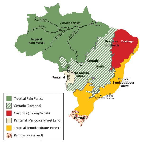
Map of Brazil's six main biomes.
The Amazon Basin: Earth's Greatest Rainforest Ecosystem
Geographical Magnitude and Hydrological Networks
The Amazon Basin occupies nearly 60 percent of Brazil's territory, encompassing approximately 5.1 million square kilometers (1.97 million square miles) within the country's borders. This vast lowland region, formed by ancient sedimentary deposits and shaped by millennia of river meandering, serves as the drainage basin for the mighty Amazon River system. The Amazon River itself, measuring approximately 6,992 km (4,345 mi) in length, ranks as the world's longest river by most measurements and carries more water than the next seven largest rivers combined.
The river's massive discharge—averaging 209,000 cubic meters per second (7.4 million cubic feet per second)—creates a freshwater plume that extends 160 km (100 mi) into the Atlantic Ocean. This immense hydrological system includes over 1,100 tributaries, with 17 of them exceeding 1,600 km (1,000 mi) in length. Major tributaries such as the Negro, Madeira, and Tapajós rivers are themselves among the world's largest waterways, creating a transportation network that has historically connected remote interior regions to coastal markets.
The basin's topography is remarkably flat, with an average elevation of just 150 m (492 ft) above sea level. This minimal gradient causes the Amazon's waters to flow slowly—approximately 2.4 km/h (1.5 mph)—allowing for extensive seasonal flooding that enriches floodplain soils and supports unique várzea (floodplain) ecosystems.
Climate Dynamics and Ecological Complexity
The Amazon experiences a hot, humid equatorial climate characterized by minimal temperature variation throughout the year. Daily temperatures typically range from 24°C to 32°C (75°F to 90°F), with humidity levels consistently above 80 percent. Annual precipitation varies significantly across the basin, from 1,500 mm (59 in) in the eastern regions to over 3,500 mm (138 in) in the western Andes foothills, with most areas receiving between 2,000 and 2,500 mm (79 and 98 in) annually.
This climatic stability has fostered the evolution of Earth's most biodiverse terrestrial ecosystem. The Amazon Rainforest harbors an estimated 10 percent of the world's known species, including over 16,000 tree species, 2.5 million insect species, 2,000 bird species, and 430 mammal species. The forest's vertical structure creates distinct microhabitats, ranging from the emergent layer, which towers 45-60 m (148-197 ft) above ground, to the shadowy forest floor, which receives less than 2 percent of the sunlight.
Iconic Amazonian wildlife includes apex predators like jaguars and harpy eagles, aquatic specialists such as pink river dolphins and giant river otters, and remarkable adaptations like poison dart frogs and electric eels. The forest's complex food webs support intricate ecological relationships, including over 3,000 species of fruit-eating fish that play crucial roles in seed dispersal.
Global Climate Regulation and Environmental Threats
The Amazon functions as a massive carbon reservoir, storing an estimated 150-200 billion tons of carbon, equivalent to 10-15 years of global carbon emissions. Through photosynthesis, the forest absorbs approximately 2 billion tons of CO₂ annually, while its transpiration processes release 20 billion tons of water vapor daily, influencing precipitation patterns across South America and beyond.
However, deforestation rates have accelerated dramatically since the 1970s, with approximately 17 percent of the original forest already lost. Annual deforestation fluctuates between 4,000 and 11,000 km² (1,544-4,247 mi²), driven primarily by cattle ranching, soybean cultivation, and infrastructure development. This destruction threatens not only regional biodiversity but also global climate stability, as deforested areas release stored carbon and lose their capacity for future carbon sequestration.
The Brazilian Highlands: A Plateau Nation's Geological Foundation
Geological Structure and Topographical Diversity
The Brazilian Highlands, also known as the Planalto Brasileiro, represent one of the Earth's extensive plateau systems, spanning approximately 4.5 million square kilometers (1.74 million square miles) across central, southeastern, and northeastern Brazil. This ancient geological formation, composed primarily of Precambrian crystalline rocks dating back 1-2 billion years, creates a complex landscape of rolling plateaus, escarpments, and river valleys with elevations ranging from 300 to 1,200 m (984 to 3,937 ft).
The highlands are subdivided into several distinct geological provinces: the Central Plateau (Planalto Central), the Atlantic Plateau (Planalto Atlântico), and the Southern Plateau (Planalto Meridional). The Central Plateau, where Brazil's capital, Brasília, is located, maintains relatively uniform elevations of 800-1,200 m (2,625-3,937 ft) and serves as the watershed divide between the Amazon, Paraná, and São Francisco river systems.
The Serra do Mar, a dramatic escarpment system running parallel to the Atlantic coast, rises abruptly from sea level to elevations exceeding 1,000 m (3,281 ft), creating a formidable barrier between the coastal lowlands and the interior plateau. This geological feature has a significant impact on Brazil's climate patterns and historical settlement patterns.
The Cerrado: A Biodiversity Hotspot
The Cerrado, Brazil's vast tropical savanna, covers approximately 2 million km² (772,204 mi²) within the highlands, making it the world's most biodiverse savanna ecosystem. This unique biome is characterized by its distinctive vegetation structure, featuring scattered trees with twisted trunks and thick bark, which are adapted to survive periodic fires, and is underlain by a continuous grass cover.
The Cerrado's plant community exhibits remarkable adaptations to nutrient-poor, acidic soils and a pronounced dry season that lasts 4-6 months. Deep root systems, some extending 15-20 m (49-66 ft) underground, access groundwater and store nutrients. The biome supports over 12,000 plant species, with approximately 44 percent found nowhere else on Earth, along with 2,800 vertebrate species, including the giant anteater, maned wolf, and the endangered jaguar.
Fire plays a crucial ecological role in the Cerrado, with natural burns occurring every 2-3 years during the dry season. These fires prevent woody encroachment, maintain grassland habitats, and stimulate new growth. Many plant species have evolved fire-dependent reproductive strategies, with some requiring heat or smoke to trigger seed germination.
Agricultural Revolution and Economic Transformation
The Brazilian Highlands have undergone dramatic agricultural transformation since the 1960s, evolving from sparsely populated rangelands to one of the world's most productive farming regions. The development of acid-tolerant crop varieties, particularly soybeans, combined with extensive lime application and modern farming techniques, has converted millions of hectares of Cerrado into highly productive agricultural land.
Brazil now ranks as the world's largest soybean producer, with the Cerrado region contributing approximately 60 percent of the country's national production. The states of Mato Grosso, Goiás, and Minas Gerais collectively produce over 100 million tons of soybeans annually, valued at more than $25 billion. This agricultural boom has transformed regional economies, creating modern cities such as Cuiabá and Goiânia, while also establishing Brazil as a global agricultural powerhouse.
The region's cattle industry is equally significant, with the Cerrado supporting over 200 million head of cattle—the world's largest commercial herd. Modern ranching operations utilize improved pasture grasses and rotational grazing systems to maximize productivity while minimizing environmental impact.
The Pantanal: The world's Largest Seasonal Wetland
Hydrological Dynamics and Seasonal Transformation
The Pantanal, encompassing approximately 210,000 km² (81,081 mi²) across Brazil, Bolivia, and Paraguay, represents the world's largest tropical wetland complex. This vast depression, formed by tectonic subsidence and sedimentary deposition, creates a shallow basin where the Paraguay River and its tributaries spread across the landscape during annual flood cycles.
The Pantanal's hydrological rhythm defines its ecological character. During the rainy season (November to March), precipitation averaging 1,000-1,400 mm (39-55 in) combines with upstream runoff to flood 70-80 percent of the wetland. Water levels rise 2-4 m (6.6-13.1 ft), creating an inland sea dotted with islands of higher ground. As the dry season approaches (April to October), floodwaters gradually recede, exposing nutrient-rich soils and concentrating wildlife around remaining water sources.
This seasonal pulse drives one of Earth's most productive ecosystems. The annual flood deposits fertile sediments while the receding waters concentrate nutrients, creating ideal conditions for plant growth and supporting massive populations of fish, birds, and mammals.
Biodiversity and Wildlife Spectacles
The Pantanal's open landscape and seasonal abundance create unparalleled opportunities for wildlife observation. The region supports healthy populations of charismatic megafauna, including an estimated 4,000-7,000 jaguars—the largest concentration in the Americas. These apex predators thrive in the Pantanal's diverse habitats, hunting caimans, capybaras, and fish during different seasons.
The wetland hosts over 650 bird species, representing 80 percent of Brazil's avian diversity. Massive flocks of wading birds, including wood storks, jabirus, and roseate spoonbills, congregate during the dry season when receding waters concentrate fish populations. The endangered hyacinth macaw, the world's largest parrot, finds ideal nesting sites among the palm trees of the Pantanal.
Aquatic life is equally impressive, with over 260 fish species supporting complex food webs. Giant otters, the world's largest otter species, hunt in family groups, while spectacled caimans and anacondas serve as apex aquatic predators. The region's 80 mammal species include giant anteaters, tapirs, and marsh deer, specially adapted to wetland environments.
Conservation Challenges and Sustainable Development
Despite its ecological importance and UNESCO World Heritage designation, the Pantanal faces mounting environmental pressures. Surrounding agricultural intensification has increased sediment loads and pesticide contamination in inflowing rivers. Upstream dam construction threatens natural flood cycles essential for ecosystem functioning.
Climate change poses additional challenges, with altered precipitation patterns potentially disrupting the seasonal flood pulse that defines Pantanal ecology. Conservation efforts focus on promoting sustainable ranching practices, protecting headwater regions, and developing ecotourism as an economic alternative to intensive agriculture.
The Coastal Region: Brazil's Atlantic Interface
Coastal Geomorphology and Marine Ecosystems
Brazil's Atlantic coastline stretches approximately 7,400 km (4,600 mi), making it the world's longest continuous tropical coastline. This diverse littoral zone encompasses sandy beaches, rocky headlands, estuarine systems, and coral reefs, shaped by 200 million years of continental drift and fluctuations in sea level.
The northern coast, from Amapá to Rio Grande do Norte, boasts extensive sandy beaches, mangrove forests, and the world's largest continuous mangrove system, located in the Amazon delta. These mangroves cover over 13,000 km² (5,019 mi²) and serve as crucial nursery habitats for marine life while protecting coastlines from erosion and storm surge.
The northeastern coast showcases Brazil's only true coral reefs, including the spectacular Abrolhos Marine National Park, home to the South Atlantic's largest coral formations. These reefs support endemic species found nowhere else on Earth, including the Brazilian manta ray and several coral species that are uniquely adapted to the region's distinct oceanographic conditions.
The Atlantic Forest: A Biodiversity Hotspot in Crisis
The Atlantic Forest (Mata Atlântica) once covered approximately 1.3 million square kilometers (502,000 square miles) along Brazil's coast, representing one of the Earth's most biodiverse ecosystems. This forest complex, isolated from the Amazon by the Cerrado, evolved unique endemic species over millions of years of separation.
Today, only 11-16 percent of the original Atlantic Forest remains, fragmented into small patches scattered across the landscape. Despite this destruction, remaining forest fragments harbor extraordinary biodiversity, with over 20,000 plant species (40 percent endemic), 850 bird species, and 370 mammal species, including charismatic species such as the golden lion tamarin and the muriqui monkey.
The forest's destruction began with European colonization in the 16th century and accelerated during the 20th century, as Brazil's population concentrated along the coast. Today, over 145 million Brazilians—approximately 70 percent of the population—live within the original boundaries of the Atlantic Forest, creating ongoing pressure for urban expansion and infrastructure development.
Economic Significance and Urban Development
The coastal region serves as Brazil's economic powerhouse, generating approximately 70 percent of the country's GDP despite occupying only 20 percent of its territory. Major metropolitan areas, including São Paulo, Rio de Janeiro, Salvador, and Recife, are concentrated in industrial production, financial services, and international trade.
Brazil's port system, primarily composed of coastal facilities, handles over 95 percent of the country's international trade. The Port of Santos, South America's largest port, processes over 130 million tons of cargo annually, including 60 percent of Brazil's agricultural exports. Modern container terminals and specialized bulk facilities have transformed Brazil into a global trading hub.
The coastal region's tourism industry contributes over $60 billion annually to Brazil's economy. World-famous destinations, such as Rio de Janeiro's beaches, Fernando de Noronha's marine sanctuaries, and Bahia's colonial architecture, attract over 6 million international visitors each year, while domestic tourism generates billions of dollars in additional revenue.
The Southern Plains: The Pampa Grasslands
Geological Formation and Landscape Characteristics
The Southern Plains, encompassing the state of Rio Grande do Sul and parts of Santa Catarina, represent the northern extension of the Pampas grasslands, shared with Argentina and Uruguay. This region, covering approximately 178,000 km² (68,726 mi²) within Brazil, features gently rolling plains with elevations ranging from sea level to 500 m (1,640 ft).
The Pampa's landscape was shaped by millions of years of sedimentary deposition from the Andes Mountains, resulting in deep, fertile soils that are ideal for agriculture. The region's temperate climate, with cold winters and warm summers, contrasts sharply with Brazil's predominantly tropical conditions.
Agricultural Excellence and Livestock Traditions
The Southern Plains have evolved into Brazil's most intensive agricultural region, combining traditional livestock ranching with modern crop production. The region produces 70 percent of Brazil's rice, 50 percent of its wheat, and significant quantities of soybeans and corn. Modern farming techniques, including precision agriculture and genetically modified crops, have made the region one of the world's most productive agricultural areas.
The Pampa's cattle industry maintains strong ties to traditional gaucho culture while adopting modern management practices. The region supports over 14 million head of cattle, producing high-quality beef for both domestic consumption and export markets. Modern ranching operations combine traditional horseback herding with GPS-guided pasture management and genetic improvement programs.
Cultural Heritage and Environmental Conservation
The gaucho culture of the Southern Plains represents a unique blend of Indigenous, European, and African influences, expressed through distinctive music, cuisine, and social traditions. Traditional skills, such as horsemanship and cattle handling, remain important cultural elements, preserved through festivals and educational programs.
Environmental conservation in the Pampa faces challenges from agricultural intensification and the invasion of exotic species. Native grasslands have been converted to crop production or replaced with exotic pasture grasses, threatening endemic species like the pampas deer and greater rhea. Conservation efforts focus on maintaining native grassland remnants and promoting sustainable ranching practices that preserve ecosystem integrity.
Environmental Challenges and Future Prospects
Brazil's geographical diversity presents both opportunities and challenges for sustainable development. Climate change threatens to disrupt established patterns, with the Amazon experiencing increased drought stress, the Cerrado facing altered precipitation patterns, and coastal regions confronting sea-level rise and intensified storms.
Conservation efforts must strike a balance between economic development and environmental protection, particularly in biodiversity hotspots such as the Atlantic Forest and Cerrado. Sustainable agricultural practices, renewable energy development, and ecosystem service payments provide pathways for reconciling economic growth with environmental stewardship.
Brazil's geographical endowment—from the carbon-storing Amazon and biodiverse Cerrado to the productive Pampa and economically vital coast—positions the nation as a critical player in global environmental governance. The country's success in managing these diverse landscapes will have a significant impact on both regional prosperity and global ecological health.
Conclusion
Brazil's geographical tapestry—encompassing the world's largest rainforest, most extensive tropical wetland, and most biodiverse savanna—creates a nation of unparalleled ecological and economic significance. These varied landscapes, shaped by millions of years of geological evolution and climatic variation, support extraordinary biodiversity while providing the foundation for Brazil's emergence as a global agricultural and economic power.
The intricate relationships between Brazil's land, climate, and life forms demonstrate the profound connections between geographical diversity and national development. From the Amazon's role in global climate regulation to the Cerrado's transformation into a major agricultural powerhouse, each region makes a unique contribution to Brazil's national identity and international significance.
Preserving Brazil's natural heritage while meeting the needs of its 215 million citizens represents one of the greatest sustainability challenges of the 21st century. The nation's success in balancing development with conservation will determine not only its future prosperity but also the health of global ecosystems and climate systems that depend on Brazil's vast and varied landscapes.
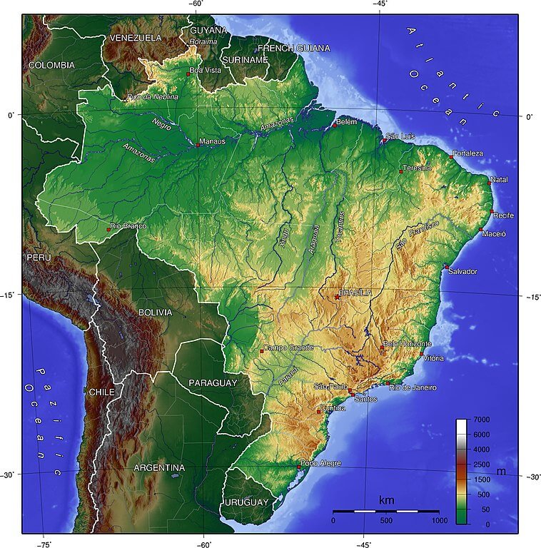
Topographical map of Brazil.