Peru's Hydrological Treasures: Exploring the Waters That Shape a Nation
Peru is one of South America's most hydrologically diverse nations, with the Amazon River marking its beginning, glacial lakes in the Andes, and ancient civilizations along its river valleys. Its water bodies form a complex network of rivers, lakes, and coastlines, shaping its landscape and society.


 https://www.flickr.com/photos/michalo/34834517404")

 via Wikimedia Commons")

Peru's Aquatic Heritage: From Andean Peaks to Pacific Shores
Peru stands as one of South America's most hydrologically diverse nations, where the mighty Amazon River begins its transcontinental journey, glacial lakes dot the towering Andes, and ancient civilizations once thrived along river valleys. The country's water bodies represent a complex network of rivers, lakes, and coastal features that have shaped both its natural landscape and human civilization for millennia. From the world's highest navigable lake to tributaries that feed the planet's largest river system, Peru's aquatic resources demonstrate remarkable geographical and ecological diversity across three distinct regions: the arid coastal zone, the mountainous Sierra, and the vast Amazon Basin.
The Amazon River System: Peru's Liquid Highway
Origins and Significance
The Amazon River, Earth's largest river by volume, originates in the Peruvian Andes at the confluence of the Ucayali and Marañón rivers near the city of Nauta. Within Peru's borders, the Amazon flows approximately 1,100 km (684 mi) eastward, collecting water from numerous tributaries before entering Brazil. The river's Peruvian section maintains an average width of 2-6 km (1.2-3.7 mi) during the dry season, expanding dramatically during floods to reach widths of up to 20 km (12.4 mi).
The Amazon's significance extends far beyond its impressive dimensions. The river system serves as the primary transportation artery for Peru's jungle regions, connecting remote communities to urban centers and facilitating trade and commerce. Cities like Iquitos, Peru's largest jungle metropolis with over 400,000 inhabitants, rely entirely on river transport for connection to the outside world, as no roads link the city to the rest of the country.
Major Tributaries
The Ucayali River, stretching 1,900 km (1,181 mi) within Peru, ranks as the country's longest river and serves as the Amazon's primary tributary. Formed by the confluence of the Tambo and Urubamba rivers, the Ucayali drains much of central Peru's eastern slopes, carrying sediments from the Andes that contribute to the Amazon's characteristic muddy appearance.
The Marañón River, flowing 1,415 km (879 mi) through Peru, represents the Amazon's second major tributary. Originating in the Cordillera Huayhuash, the Marañón cuts through dramatic gorges and canyons before joining the Ucayali. The river's upper reaches feature some of the world's deepest canyons, with walls rising over 3,000 m (9,843 ft) above the water level.
Other significant tributaries include the Huallaga River, which flows 1,138 km (707 mi) through the country's central jungle regions, and the Madre de Dios River. This 655 km (407 mi) waterway drains the southeastern rainforests of Peru. These tributaries, along with dozens of smaller rivers, create a network of waterways that penetrate deep into Peru's interior, supporting diverse ecosystems and human settlements.
Lake Titicaca: The Sacred Waters of the Altiplano
Physical Characteristics
Lake Titicaca, situated at 3,812 m (12,507 ft) above sea level on the border between Peru and Bolivia, holds the distinction of being the world's highest navigable lake. The lake covers approximately 8,372 square kilometers (3,232 square miles), with Peru controlling the western portion, which comprises about 60% of the total area. Titicaca reaches maximum depths of 284 m (932 ft) and maintains an average depth of 107 m (351 ft).
The lake's waters remain remarkably stable in temperature throughout the year, ranging from 13 °C to 16°C (55°F to 61°F), due to its massive thermal mass. This temperature regulation creates a unique microclimate around the lake, moderating the harsh conditions typical of the Altiplano and enabling agriculture at altitudes where crops would otherwise fail.
Cultural and Ecological Importance
Lake Titicaca holds profound cultural significance for Peru's Indigenous peoples, particularly the Aymara and Quechua communities, who have inhabited its shores for over 3,000 years. According to Inca mythology, the lake served as the birthplace of the first Inca ruler, Manco Capac, and his sister-wife Mama Ocllo. The lake contains numerous islands, including Amantaní, Taquile, and the famous floating islands of the Uros people, constructed entirely from totora reeds.
The lake supports unique endemic species, including the Titicaca water frog, found nowhere else on Earth. However, the ecosystem faces mounting pressure from pollution, overfishing, and climate change, with water levels fluctuating significantly in recent decades.
Coastal Rivers and Pacific Drainage
The Western Watershed
Peru's coastal region is characterized by numerous short but significant rivers that drain the western slopes of the Andes into the Pacific Ocean. These rivers, although relatively short in length, play a crucial role in supporting agriculture and urban populations in one of the world's most arid regions. The coastal desert receives less than 25 mm (1 in) of annual rainfall, making these rivers essential lifelines for over half of Peru's population.
The Rimac River, flowing 160 km (99 mi) from the Andes to the Pacific, provides water for Lima, Peru's capital and largest city, with over 10 million inhabitants. Despite its modest size, the Rimac supports nearly one-third of Peru's population, highlighting the critical importance of Andean water resources for coastal communities.
Other significant coastal rivers include the Chira, Peru's most voluminous Pacific-draining river at 280 km (174 mi), and the Santa River, which flows 320 km (199 mi) through the Callejón de Huaylas before reaching the ocean. These rivers enable intensive agriculture in coastal valleys, supporting a range of crops, from cotton and sugarcane to asparagus and grapes, for export.
Seasonal Patterns and Water Management
Coastal rivers exhibit extreme seasonal variation, with flows increasing dramatically during the December-April rainy season in the Andes. This irregularity necessitates the development of extensive water management infrastructure, including reservoirs, irrigation systems, and flood control measures. The Poechos Reservoir on the Chira River, with a capacity of 1,000 million cubic meters, exemplifies the engineering solutions required to manage these variable water resources.
High-Altitude Lakes of the Andes
Glacial and Tectonic Origins
The Peruvian Andes are home to hundreds of high-altitude lakes formed through glacial action and tectonic processes. These water bodies, typically situated above 3,500 m (11,483 ft) elevation, serve as crucial water reservoirs for lower-elevation communities and ecosystems. Many originated during the last ice age when glaciers carved deep valleys that later filled with water as the ice retreated.
Lake Junín, Peru's second-largest lake at 530 square kilometers (205 square miles), sits at an elevation of 4,080 meters (13,386 feet) in the central Andes. The lake supports important bird populations, including the endangered Junín grebe, and provides water for hydroelectric generation and downstream communities.
The Cordillera Huayhuash and Cordillera Blanca regions are home to numerous glacial lakes, including Lake Parón, Lake Llanganuco, and Lake Churup. These pristine alpine lakes attract international tourists and mountaineers while serving as headwaters for major river systems.
Environmental Challenges
High-altitude lakes face increasing pressure from climate change, with rising temperatures causing glacial retreat and altering precipitation patterns. Mining activities in the Andes also pose contamination risks, as heavy metals and processing chemicals can enter lake systems through surface runoff and groundwater infiltration.
Wetlands and Specialized Aquatic Ecosystems
Coastal Wetlands
Peru's coast features several important wetland systems, including the Pantanos de Villa in Lima and the Paracas National Reserve. These wetlands, sustained by a combination of river discharge, groundwater seepage, and coastal fog, provide critical habitat for migratory birds and endemic species despite the surrounding desert environment.
The Pantanos de Villa, covering 263 hectares (650 acres), supports over 150 bird species and serves as a crucial stopover point for birds migrating along the Pacific Flyway. The wetland's five interconnected lagoons demonstrate the complex hydrology possible even in extremely arid conditions.
Amazonian Wetlands
The Amazon basin contains extensive seasonal wetlands known as várzeas, which flood annually during the rainy season. These temporarily flooded forests cover millions of hectares and support unique plant and animal communities adapted to alternating wet and dry conditions. The Pacaya-Samiria National Reserve, encompassing 20,800 square kilometers (8,031 square miles), protects one of Peru's largest intact wetland systems.
River Systems of the Eastern Slopes
The Transition Zone
Between the high Andes and the Amazon lowlands lies a transition zone where rivers cascade through cloud forests and montane ecosystems. Rivers like the Urubamba, Apurímac, and Mantaro begin as mountain torrents before gradually widening and slowing as they approach the Amazon Basin.
The Urubamba River, sacred to the Inca civilization, flows 862 km (536 mi) from the Andes through the Sacred Valley past Machu Picchu before joining the Ucayali. The river's diverse course encompasses glacial headwaters, agricultural valleys, and tropical rainforest, demonstrating Peru's remarkable ecological transitions.
Hydroelectric Potential
The steep gradients of Andean rivers provide significant hydroelectric potential, with several major projects harnessing this renewable energy source. The Mantaro River system generates over 40% of Peru's electrical power through a series of dams and power plants. However, dam construction often conflicts with environmental conservation and Indigenous rights, creating ongoing debates about sustainable development.
Summary
Peru's water bodies represent a remarkable diversity of aquatic environments, from the world's highest navigable lake to the birthplace of the planet's largest river. The country's hydrological resources span three distinct geographical regions, each presenting unique characteristics and challenges. Lake Titicaca continues to serve as both a cultural touchstone and a critical water reservoir for the Altiplano. At the same time, the Amazon River system provides transportation, sustenance, and ecological services for millions of inhabitants. Coastal rivers, though limited in number and seasonal in flow, support Peru's most populous regions through carefully managed irrigation and water supply systems.
The Andean lakes, formed by glacial and tectonic processes, offer pristine environments and crucial water storage, though they face mounting pressure from climate change and human activities. Wetland systems, both coastal and Amazonian, provide essential ecosystem services and habitat for diverse species. The rivers of the eastern slopes demonstrate Peru's remarkable ecological transitions, flowing from glacial origins through cloud forests to tropical lowlands.
Peru's aquatic heritage faces significant challenges in the 21st century, including climate change, pollution, overexploitation, and competing demands for water resources. The country's water bodies will require careful management and protection to ensure their continued contribution to Peru's ecological integrity, cultural identity, and economic prosperity. Understanding and preserving these diverse aquatic systems remains crucial for Peru's sustainable development and the global health of critical ecosystems, such as the Amazon Basin.
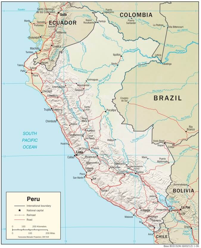
Peru physiographic map.
Notable Water Bodies of Peru
Rivers
Amazon River
- Length in Peru: 1,100 km (684 mi)
- Location: Eastern Peru, from Nauta to the Brazilian border
- Significance: The world's largest river by volume
Ucayali River
- Length: 1,900 km (1,181 mi)
- Location: Central-eastern Peru
- Significance: Longest river entirely within Peru
Marañón River
- Length: 1,415 km (879 mi)
- Location: Northern Peru, from Cordillera Huayhuash to Amazon confluence
- Significance: Major Amazon tributary
Huallaga River
- Length: 1,138 km (707 mi)
- Location: Central Peru, flows north to the Amazon
- Significance: Important transportation route
Madre de Dios River
- Length: 655 km (407 mi)
- Location: Southeastern Peru
- Significance: Drains southeastern rainforests
Urubamba River
- Length: 862 km (536 mi)
- Location: Southern Peru, through the Sacred Valley
- Significance: Sacred to Inca civilization, passes Machu Picchu
Apurímac River
- Length: 730 km (454 mi)
- Location: Southern Peru
- Significance: Historically considered Amazon's source
Santa River
- Length: 320 km (199 mi)
- Location: Western Peru, Callejón de Huaylas to the Pacific
- Significance: Major coastal river
Chira River
- Length: 280 km (174 mi)
- Location: Northwestern Peru
- Significance: The most voluminous Pacific-draining river
Rimac River
- Length: 160 km (99 mi)
- Location: Central coast, supplies Lima
- Significance: Water source for the capital city
Lakes
Lake Titicaca
- Area: 8,372 sq km (3,232 sq mi) total; Peru controls ~5,000 sq km (1,931 sq mi)
- Location: Peru-Bolivia border, Puno region
- Elevation: 3,812 m (12,507 ft)
- Significance: The world's highest navigable lake
Lake Junín
- Area: 530 sq km (205 sq mi)
- Location: Central Andes, Junín region
- Elevation: 4,080 m (13,386 ft)
- Significance: Peru's second-largest lake
Lake Parón
- Area: 3.5 sq km (1.4 sq mi)
- Location: Cordillera Blanca, Ancash region
- Elevation: 4,185 m (13,730 ft)
- Significance: The Largest lake in Cordillera Blanca
Llanganuco Lakes
- Area: Combined 1.2 sq km (0.5 sq mi)
- Location: Cordillera Blanca, Ancash region
- Elevation: 3,850 m (12,631 ft)
- Significance: Twin glacial lakes (Chinancocha and Orconcocha)
Lake Sandoval
- Area: 1.3 sq km (0.5 sq mi)
- Location: Madre de Dios region, Tambopata National Reserve
- Significance: Oxbow lake, an important wildlife habitat
Coastal Features
Pantanos de Villa
- Area: 263 hectares (650 acres)
- Location: Lima, central coast
- Significance: Urban wetland, migratory bird habitat
Paracas Bay
- Area: 50 sq km (19 sq mi)
- Location: Ica region, central coast
- Significance: Protected marine ecosystem
Pacaya-Samiria National Reserve (wetlands)
- Area: 20,800 sq km (8,031 sq mi)
- Location: Loreto region, Amazon basin
- Significance: The Largest protected wetland in Peru
Reservoirs
Poechos Reservoir
- Capacity: 1,000 million cubic meters
- Location: Piura region, Chira River
- Significance: The Largest reservoir in Peru
Gallito Ciego Reservoir
- Capacity: 400 million cubic meters
- Location: La Libertad region, Jequetepeque River
- Significance: Important irrigation and flood control