The Urubamba River: Sacred Waters from Andes to Amazon
The Urubamba River flows from the Peruvian Andes to the Amazon Basin. It passes through various ecological zones, supporting a wide range of ecosystems. Beyond agriculture in the Sacred Valley, it is essential to Quechua spirituality and continues to uphold Indigenous communities.


 via Wikimeida Commons")
 via Wikimedia Commons")
 https://www.flickr.com/photos/aolinex/3274940828")
Willkamayu: Following Peru's Most Sacred River from Glacial Source to Rainforest
In the high peaks of Peru's Cordillera Vilcanota, where glacial ice meets equatorial sun at elevations exceeding 5,000 meters (16,404 feet), countless tributaries converge to birth one of South America's most culturally and ecologically significant waterways. The Urubamba River, revered by the Incas as Willkamayu—the Sacred River—embarks on a remarkable 724-kilometer (450-mile) journey that transforms it from a crystalline mountain stream into a mighty Amazonian tributary, descending over 4,000 meters (13,123 feet) in elevation while traversing some of the continent's most diverse ecosystems.
This extraordinary river serves as both a geographical spine and a cultural artery for millions of people across Peru, connecting the snow-capped Andes with the verdant Amazon Basin through a hydrological pathway that has shaped human civilization for over two millennia. From its role as the Sacred Valley's agricultural foundation to its function as a major Amazon tributary supporting one of the world's most biodiverse regions, the Urubamba represents a remarkable example of how water systems can sustain complex relationships between human communities and natural environments.
Hydrographic Origins: Born from Ice and Stone
The Urubamba's headwaters emerge from the Cordillera Vilcanota's glacial fields, where the Quelccaya Ice Cap—South America's largest tropical ice sheet—feeds numerous tributaries that converge near Sicuani at 3,550 meters (11,647 feet) above sea level. The river begins its northwestern journey as the Vilcanota River, carrying glacial meltwater enriched with mineral sediments that nourish agricultural terraces and natural ecosystems throughout its course.
Recent glaciological studies indicate that the Quelccaya Ice Cap has retreated approximately 20% since 1963, fundamentally altering the river's hydrological patterns. During the dry season (May through September), glacial melt provides crucial base flow averaging 45 cubic meters per second (1,590 cubic feet per second) near Cusco, while wet season flows can exceed 400 cubic meters per second (14,126 cubic feet per second) due to concentrated precipitation in the upper watershed.
The river's upper course flows through high-altitude valleys where traditional Quechua communities maintain potato cultivation at elevations reaching 4,200 meters (13,780 feet)—among the highest agricultural zones in the world. These highland sections create wetland habitats supporting endemic species like the Titicaca water frog (Telmatobius culeus) and various high-altitude waterfowl species.
The Sacred Valley Passage: Cultural and Agricultural Heartland
As the Urubamba enters the Sacred Valley near Pisac, it transforms into the agricultural lifeline that sustained the Inca Empire and continues to support contemporary Indigenous communities. The river's meandering course through this 100-kilometer (62-mile) valley section creates fertile alluvial deposits averaging 200 meters (656 feet) in width, providing some of the Andes' most productive agricultural land.
The valley's unique microclimate, moderated by the river's thermal mass at elevations of 2,800-3,400 meters (9,186-11,155 feet), enables cultivation of both temperate and subtropical crops within a relatively small geographic area. Traditional agricultural terraces, many of which are still functional after five centuries, demonstrate sophisticated water management techniques that channel river water through gravity-fed irrigation systems covering over 40,000 hectares (98,842 acres) of cultivated land.
Inca-constructed channel diversions remain functional today, directing water through carefully graded canals that maintain optimal flow rates for different crop types. These ancient systems achieve water distribution efficiency rates exceeding 85%, comparable to contemporary drip irrigation technologies, while requiring no external energy sources or mechanical components.
The river's ecological role extends beyond agricultural irrigation to the creation of wetlands that support diverse wildlife populations. Riparian forests harbor over 200 documented bird species, including the endangered Andean cock-of-the-rock (Rupicola peruvianus) and various hummingbird species adapted to high-altitude flowering plants.
The Dramatic Descent: From Valley to Cloud Forest
Beyond Ollantaytambo, the Urubamba plunges through dramatic gorges that compress multiple ecological zones into vertical sequences spanning less than 50 kilometers (31 miles) horizontally while descending over 1,400 meters (4,593 feet) in elevation. This section, known as the Urubamba Canyon, creates one of South America's most ecologically diverse corridors.
Cloud forests begin appearing at approximately 2,500 meters (8,202 feet) elevation, where the river's humid microclimate combines with orographic precipitation to create perpetually moist conditions supporting extraordinary biodiversity. These montane forests contain some of South America's highest levels of endemic species, with botanical surveys documenting over 1,500 vascular plant species within the watershed's cloud forest zones.
Wildlife diversity reaches exceptional levels in this transition zone, where Andean and Amazonian fauna overlap in unique assemblages. Spectacled bears (Tremarctos ornatus) inhabit the upper elevations, while jaguar (Panthera onca) tracks have been documented in lower cloud forest areas. Over 400 bird species have been recorded along this section, including numerous endemics like the Inca wren (Pheugopedius eisenmanni) found nowhere else on Earth.
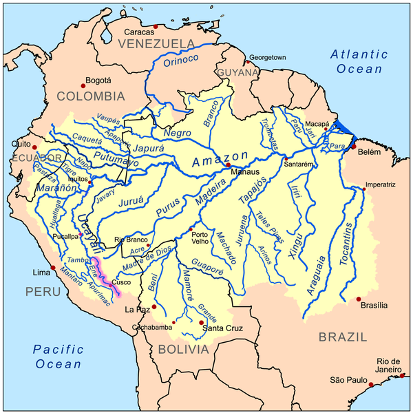
Map depicting the Amazon Basin with the Urubamba River highlighted.
Lowland Transformation: Entry into Amazonia
As the Urubamba emerges from the Andes foothills near Quillabamba at an elevation of 1,050 meters (3,445 feet), it undergoes its final transformation into a major Amazonian river system. The channel widens significantly, and the surrounding landscape transitions to lowland tropical rainforest that supports some of the world's highest biodiversity levels.
This lowland section, extending approximately 400 kilometers (249 miles) to the river's confluence with the Tambo River, demonstrates the Urubamba's role as a major tributary of the Ucayali-Amazon system. Average discharge increases to over 2,000 cubic meters per second (70,629 cubic feet per second) due to numerous tributary inputs from both Andean foothills and lowland rainforest watersheds.
The river's meandering course through lowland forests creates oxbow lakes, seasonal floodplains, and gallery forests, which support an extraordinary biological diversity. Scientific expeditions have documented over 3,000 plant species, 600 bird species, and 200 mammal species within the Urubamba's lowland watershed, including flagship species such as the giant otter (Pteronura brasiliensis), the pink river dolphin (Inia geoffrensis), and numerous primate species.
Cultural and Spiritual Significance: The Sacred River
For the Quechua peoples who have inhabited the Urubamba watershed for over a millennium, the river represents the sacred connection between earthly and celestial realms that forms the foundation of Andean cosmology. The river's Quechua name, Willkamayu, translates to "Sacred River" or "Sun River," reflecting its central role in the region's religious and cultural practices that continue to this day.
Inca mythology identified the Urubamba as the terrestrial reflection of the Milky Way, with the river's meandering course through the Sacred Valley corresponding to the galaxy's path across the night sky. This cosmic connection influenced the placement of major ceremonial sites, with temples and observatories positioned to align with both the river's course and important astronomical events.
Traditional ceremonies honoring the river continue throughout the watershed, with Indigenous communities offering coca leaves, chicha corn beer, and elaborate despachos (ritual bundles) at sacred sites along the river's banks. These practices maintain reciprocal relationships between human communities and the water spirits believed to control the river's flow and capacity to sustain life throughout the watershed.
Contemporary Indigenous movements have embraced the river as a symbol of environmental and cultural rights, with organizations advocating for the recognition of the river's rights as a living entity that deserves legal protection. These efforts reflect growing international recognition that rivers possess intrinsic value that transcends their utility for human purposes.
Historical Significance: River of Empire and Exploration
The Urubamba's role in human history includes its function as a transportation corridor that enabled the expansion of Andean civilizations and later facilitated European exploration of South America's interior. Archaeological evidence indicates that complex societies have utilized the river for trade and communication for over 2,000 years, with the Inca Empire representing the culmination of this long history of river-based cultural development.
During the height of Inca power (1200-1533 CE), the Urubamba served as a crucial link between the empire's highland capital at Cusco and the tropical lowlands that provided coca, exotic birds, gold, and other luxury goods essential to imperial ceremonies. Inca road networks followed the river's course through the Sacred Valley and into the cloud forest, with way stations and administrative centers positioned at strategic intervals to control trade and maintain communication throughout the watershed.
Spanish colonial chronicles document the river's continued importance during the conquest period, with expeditions using the Urubamba as an access route to explore the eastern slopes of the Andes and establish contact with Indigenous Amazonian peoples. The 19th and early 20th centuries brought scientific expeditions that utilized the river as a pathway for biological and geographical exploration, contributing to early understanding of Amazonian biodiversity.
Traditional Ecological Knowledge: Indigenous Watershed Stewardship
Indigenous communities throughout the Urubamba watershed have developed sophisticated ecological knowledge systems that enable sustainable resource use while maintaining ecosystem health across diverse environmental conditions. These traditional practices offer crucial insights for contemporary watershed management and climate change adaptation strategies.
High-altitude Quechua communities practice rotational agriculture systems that maintain soil fertility while preserving native crop genetic diversity. Traditional farming calendars synchronized with astronomical observations and river flow patterns optimize planting and harvesting times, while community-managed seed banks preserve heirloom varieties adapted to specific microclimatic conditions.
Water management techniques developed over centuries include sophisticated irrigation systems that distribute river water efficiently while maintaining aquatic habitat connectivity. Traditional canal networks use gravity flow and carefully constructed distribution points to deliver water where needed while returning excess flow to the main channel, creating systems that function reliably without external energy inputs.
Lowland Indigenous communities have developed sustainable fishing practices that maintain fish populations while meeting subsistence needs. These systems include seasonal fishing restrictions that protect spawning areas, rotational use of different water bodies that allow population recovery, and selective harvesting techniques that maintain age structure and genetic diversity within fish populations.
Contemporary Challenges and Conservation
The Urubamba watershed faces complex challenges that reflect broader tensions between economic development, environmental conservation, and Indigenous rights throughout the Andean-Amazonian region. Climate change, tourism growth, extractive industries, and agricultural intensification create cumulative pressures that require integrated management approaches.
Climate change impacts are already visible throughout the watershed, with glacial retreat reducing dry season flows while changing precipitation patterns alter traditional agricultural calendars. Temperature increases are shifting species distributions upslope, potentially causing local extinctions of cold-adapted species while enabling invasive species to colonize new areas.
Tourism development, while providing economic opportunities for local communities, also creates infrastructure pressures and waste management challenges that threaten water quality and ecosystem health. The Sacred Valley receives over 1.5 million visitors annually, generating impacts that require careful management to prevent environmental degradation.
Conservation initiatives throughout the watershed reflect the complex challenges of protecting biodiversity while supporting Indigenous rights and sustainable development. The Historic Sanctuary of Machu Picchu protects 32,592 hectares (80,535 acres) of the upper Urubamba watershed, while community conservation agreements enable Indigenous communities to receive support for traditional resource management practices that maintain ecosystem health.
Economic and Future Significance
The Urubamba River's economic importance extends beyond its immediate watershed to include its role in national development, international tourism, and regional food security. Agriculture throughout the watershed generates significant value through both subsistence production and commercial crops that supply urban markets. Tourism associated with the river and its archaeological sites generates over $500 million annually in direct economic activity.
The watershed's role in providing clean water for urban areas, including Cusco, represents a crucial ecosystem service that would be extremely expensive to replace through technological alternatives. Protecting watershed forests and traditional water management systems provides cost-effective solutions for urban water supply while supporting rural livelihoods and biodiversity conservation.
Climate adaptation strategies must address both gradual changes, such as glacial retreat, and extreme events that are likely to become more frequent due to climate change. Sustainable tourism development offers opportunities to generate economic benefits while supporting conservation objectives, requiring innovative approaches that distribute benefits equitably while managing visitor impacts.
Conclusion: The Eternal Flow of Sacred Waters
The Urubamba River continues its ancient journey from Andean peaks to Amazonian forests, carrying with it the accumulated wisdom of countless generations who have learned to live sustainably within its watershed. As it flows through landscapes shaped by both geological forces and human ingenuity, the river embodies the fundamental connections between water, land, and culture that define human relationships with the natural world.
From its glacial origins, where traditional communities maintain agricultural systems adapted to extreme altitudes, through the Sacred Valley, where Inca engineering achievements continue to function after five centuries, to the lowland forests where Indigenous peoples sustain themselves through sophisticated ecological knowledge, the Urubamba demonstrates that sustainable relationships between human communities and river systems are not only possible but essential for long-term prosperity.
The sacred waters continue their eternal flow toward the Amazon, carrying with them the hopes and dreams of millions of people whose lives depend on maintaining the delicate balance between human needs and ecosystem health. The Urubamba's story is ultimately about the possibility of sustainability—the demonstration that human communities can thrive within natural limits when guided by wisdom accumulated over generations of careful observation and respectful stewardship.
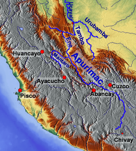
Relief map of central Peru.