The Antarctic Plate: Guardian of the Southern Ocean
The Antarctic Plate forms the tectonic foundation beneath Antarctica and the surrounding Southern Ocean. This massive continental plate exhibits unique geological processes operating under extreme polar conditions, while playing a crucial role in global ocean circulation and climate systems.
 https://www.flickr.com/photos/24354425@N03/38060745765")
Polar Dynamics: How the Antarctic Plate Shapes Southern Ocean Geology
The Antarctic Plate, covering approximately 60.9 million square kilometers (23.5 million square miles), forms the tectonic foundation beneath Antarctica and the surrounding Southern Ocean. This massive continental plate exhibits unique geological processes operating under extreme polar conditions, ranging from subglacial volcanism to interactions between ice sheets and tectonics, while playing a crucial role in global ocean circulation and climate systems.
Geological Structure and Composition
The Antarctic Plate comprises ancient continental crust beneath East Antarctica, as well as younger oceanic and continental crust under West Antarctica. East Antarctica contains some of Earth's oldest rocks, with zircon crystals dating to 4.0 billion years ago. In comparison, West Antarctica consists of accreted terranes and volcanic rocks formed during the past 500 million years.
The continental crust varies dramatically in thickness, reaching over 60 kilometers (37 miles) beneath the Transantarctic Mountains while thinning to less than 25 kilometers (15 miles) in some West Antarctic regions. This variation reflects the different geological histories and ongoing processes that continue to shape the continent.
The plate's oceanic portions extend far into the Southern Ocean, encompassing mid-ocean ridge systems that connect Antarctica to other continents. These ridges represent some of the most active spreading centers on Earth, despite their remote polar location.
East Antarctic Craton: Ancient Foundation
East Antarctica contains one of Earth's most stable continental cratons, preserving rocks formed during the planet's early history. The Archean and Proterozoic rocks record ancient continental collision processes, providing insights into early Earth conditions.
The Transantarctic Mountains, extending over 3,500 kilometers (2,175 miles) across the continent, mark the boundary between East and West Antarctica. These mountains formed through multiple episodes of uplift and contain important fossil deposits that document Antarctica's biological history before its current icy conditions.
Subglacial topography reveals complex geological structures beneath the ice sheet, including major sedimentary basins, volcanic provinces, and ancient mountain ranges. Recent discoveries using ice-penetrating radar and seismic surveys continue to reveal new aspects of Antarctica's hidden geology.
West Antarctic Rift System
West Antarctica represents one of the world's major continental rift systems, characterized by crustal extension, volcanism, and complex fault patterns. The West Antarctic Rift System (WARS) spans approximately 3,000 kilometers (1,865 miles) from the Ross Sea to the Antarctic Peninsula, representing active continental rifting processes.
The rift system comprises major sedimentary basins filled with thousands of meters of sediments deposited over the past 100 million years. These basins provide crucial records of Antarctica's geological and climate history, including evidence for past ice sheet fluctuations and volcanic activity.
Active volcanism within the rift system includes Mount Erebus, Antarctica's most active volcano, which maintains a permanent lava lake at its summit. Subglacial volcanism also occurs throughout West Antarctica, creating complex interactions between volcanic heat and ice sheet dynamics.
Subglacial Volcanism and Ice Sheet Interactions
The Antarctic Plate hosts extensive subglacial volcanic activity, which profoundly influences the behavior and stability of the ice sheet. Over 130 subglacial volcanoes have been identified beneath West Antarctica, with many showing signs of recent activity.
Subglacial volcanic heat creates complex feedback systems with ice sheet dynamics. Volcanic heat can thin ice from below, create subglacial lakes, and influence ice flow patterns. The Pine Island and Thwaites glaciers, among Antarctica's most rapidly changing ice streams, flow over geologically active areas that may impact their behavior.
Marie Byrd Land contains the largest known concentration of subglacial volcanoes, including several that have erupted through the ice sheet within the past 10,000 years. These interactions between volcanism and ice create unique environments and influence the stability of regional ice sheets.
Plate Boundaries and Mid-Ocean Ridges
The Antarctic Plate's boundaries consist entirely of divergent and transform margins, making it unique among major plates in that it lacks subduction zones. The plate spreads away from surrounding plates along extensive mid-ocean ridge systems that encircle much of Antarctica.
The Southwest Indian Ridge extends from the Bouvet Triple Junction to the Rodriguez Triple Junction, separating the Antarctic and African plates. Spreading rates along this ridge average 15-16 millimeters (0.6 inches) per year, typical of slow-spreading ridges globally.
The Southeast Indian Ridge separates the Antarctic and Australian plates, extending from the Rodriguez Triple Junction to the Macquarie Triple Junction near New Zealand. This ridge system exhibits intermediate spreading rates of 60-75 millimeters (2.4-3.0 inches) per year.
The Pacific-Antarctic Ridge forms the boundary with the Pacific Plate, extending from the Macquarie Triple Junction toward South America. The Chile Ridge continues this system, forming the boundary between the Antarctic and Nazca plates from the Chile Triple Junction northward. Spreading rates increase eastward along these ridges, reaching over 90 millimeters (3.5 inches) per year along the Chile Ridge, making it one of the fastest-spreading ridge segments globally.
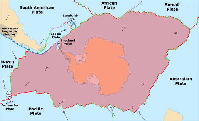
Map depicting the location of the Antarctic Plate.
Southern Ocean Circulation and Tectonic Connections
The Antarctic Plate's position and boundary configuration fundamentally control Southern Ocean circulation patterns, which significantly influence global climate systems. The Antarctic Circumpolar Current, the world's largest ocean current, flows around Antarctica largely due to the continent's isolated position and the surrounding deep ocean basins.
Tectonic processes continuously modify ocean basin geometry, influencing circulation patterns over geological time scales. The gradual separation of Antarctica from other continents created the current configuration that allows the Antarctic Circumpolar Current to isolate Antarctica thermally.
Ridge-spreading processes create new oceanic crust, which influences ocean depth and circulation patterns. The interaction between tectonics and oceanography demonstrates how geological processes affect global climate systems.
Interactions with Neighboring Plates
The Antarctic Plate interacts with six neighboring plates through diverse boundary types and processes. The boundary with the South American Plate involves the small Scotia Plate, creating the complex Scotia Arc system that accommodates the relative motion between Antarctica and South America.
The Australian-Antarctic boundary represents a typical slow-spreading ridge system, though it includes the anomalous Macquarie Ridge where transform motion transitions to minor convergence. This unusual boundary demonstrates how plate boundaries can evolve and change character over time.
The African-Antarctic boundary includes the Bouvet Triple Junction, one of the most isolated triple junctions on Earth. This junction point influences regional tectonics and provides insights into how three-plate systems evolve and maintain stability.
The boundary with the Nazca Plate along the Chile Ridge represents one of the most rapidly spreading segments in the Southern Ocean. This ridge system connects to the Chile Triple Junction, where the Antarctic, Nazca, and South American plates meet in a complex geometric arrangement that accommodates the different motion vectors of these three major plates.
Seismic Activity and Geological Hazards
Despite lacking subduction zones, the Antarctic Plate experiences significant seismic activity along its extensive ridge boundaries. Transform faults along ridge segments generate frequent moderate earthquakes, while ridge spreading processes create volcanic activity.
The most seismically active regions include the Scotia Arc, where complex interactions between the Antarctic, South American, and Scotia plates create frequent earthquakes. The 2003 Scotia Sea earthquake (M 7.6) demonstrated the potential for large events in this region.
Subglacial volcanic eruptions pose unique hazards to ice sheet stability and could potentially contribute to rapid ice loss if major eruptions occur beneath thick ice. However, the remote location and harsh conditions make direct observation of most Antarctic seismic and volcanic activity extremely difficult.
Climate Record and Ice Sheet History
The Antarctic Plate preserves crucial records of past climate changes and ice sheet fluctuations through geological and glaciological evidence. Marine sediment cores from the Southern Ocean document the history of ice sheet advance and retreat over millions of years.
Volcanic ash layers in ice cores and marine sediments provide precise timing for past volcanic eruptions, allowing for correlation between geological and climate records. These records demonstrate complex interactions between volcanism, tectonics, and ice sheet behavior over geological time scales.
The plate's geological evolution influenced Antarctica's transition from a temperate continent with forests to its current ice-covered state. Understanding this transition provides crucial insights into how geological processes interact with climate systems over long time scales.
Biological and Ecological Connections
Despite extreme conditions, the Antarctic Plate supports unique ecosystems that are adapted to the polar environment and geological processes. Hydrothermal vents along mid-ocean ridges host specialized biological communities that thrive in the deep, cold waters of the Southern Ocean.
Subglacial lakes created by geothermal heating represent unique environments that may harbor ancient microbial life. Lake Vostok and other subglacial lakes serve as natural laboratories for studying life under extreme conditions and as potential analogues for extraterrestrial environments.
Endemic species such as Belgica antarctica, Antarctica's only native insect, demonstrate adaptation to the extreme conditions created by the continent's geological and climatic evolution. These organisms provide insights into biological responses to environmental extremes.
Resource Potential and Environmental Protection
The Antarctic Plate is likely to contain significant mineral and energy resources, including coal deposits, metallic ores, and potentially petroleum reserves. However, the Antarctic Treaty System prohibits commercial mineral exploitation, preserving the continent for scientific research and environmental protection.
Scientific research on the Antarctic Plate provides crucial insights into global geological processes, climate systems, and biological adaptation. International cooperation in Antarctic research demonstrates how scientific collaboration can transcend political boundaries and address global challenges.
The plate's role in global climate systems makes understanding its geological processes crucial for predicting future climate changes and the behavior of ice sheets. This knowledge becomes increasingly important as global warming accelerates changes in polar regions.
The Antarctic Plate exemplifies how geological processes operate under extreme conditions and influence global systems through complex feedbacks between tectonics, climate, and ice sheet dynamics. Its continuing evolution affects global sea level, ocean circulation, and climate patterns, making it one of the most globally significant tectonic entities despite its remote location.
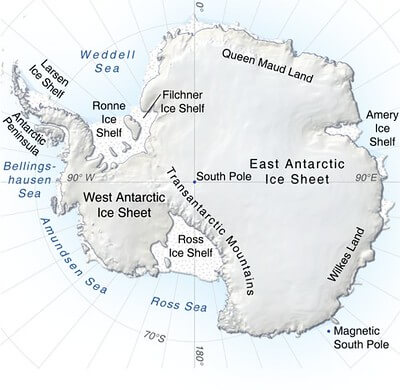
Topographic map of Antarctica.