The Lesser Antilles Volcanic Arc: Unlocking the Mysteries
The Lesser Antilles Volcanic Arc is a geological formation that shapes the Caribbean Sea. It's a chain of islands from Grenada to Sombrero resulting from the subduction of the North American Plate beneath the Caribbean Plate. It's home to a diverse range of volcanic landforms.
 https://www.flickr.com/photos/79721788@N00/46428778325")
 - (CC BY-NC 2.0)")


 https://www.flickr.com/photos/tamsintog/2568499031")

The Lesser Antilles Volcanic Arc and Subduction Zone: Unlocking the Mysteries
The Lesser Antilles Volcanic Arc is a chain of volcanic islands stretching from the Virgin Islands to Grenada in the eastern Caribbean Sea. It is formed by the subduction of the North American Plate beneath the Caribbean Plate, which creates the volcanoes that make up the islands. This volcanic arc, along with other geological forces, contributes to the shaping of the Caribbean Sea.
Geological Framework
Geographically, the Lesser Antilles forms a long arc of islands in the Caribbean Sea, tracing the outer cliff of the Caribbean Plate. This curved chain, approximately 850 kilometers (500 miles) in length, extends from Grenada to Sombrero. However, the island arc bifurcates north of Dominica, with only the western arc remaining active in volcanic activity.
According to the University of the West Indies (UWI) Seismic Centre, the Lesser Antilles region hosts 19 active volcanoes distributed across 11 islands. Each island, whether hosting a single live volcano or multiple potentially active ones, contributes to the dynamic nature of the volcanic arc.
Active Volcanoes in the Region
Numerous islands in the Lesser Antilles region boast live volcanoes, each with its own potential for eruption. Notable active volcanoes include Dominica, with one volcano; Grenada, with three volcanoes; and Guadeloupe, Martinique, Montserrat, Nevis, Saba, Saint Kitts, Saint Vincent, Saint Lucia, Sint Eustatius, with one volcano each.
Among the most active live volcanoes in the region are Soufriere Hills in Montserrat, La Grande Soufrière in Guadeloupe, Mount Pelée in Martinique, La Soufrière in Saint Vincent), and Kick 'em Jenny, a submarine volcano about 10 km (6 mi) north of Grenada
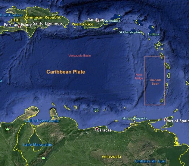
Map depicting the Antilles / Grenada Basin.
The Lesser Antilles Subduction Zone
The Lesser Antilles Subduction Zone is a convergent plate boundary on the seafloor. It involves the subduction of the North American Plate crust beneath the Caribbean Plate. This geological process is known as subduction, and it occurs when one tectonic plate moves beneath another due to high gravitational potential energy, sinking into the mantle.
The Lesser Antilles' subduction process is oblique subduction, which means that the plates are moving not only directly toward each other but also slightly sideways. This contributes to the region's unique tectonic and volcanic activity.
The ongoing subduction of the North American Plate crust under the Caribbean Plate has led to the creation of many volcanic islands. From the Virgin Islands in the north to the islands off the coast of Venezuela in the south, the Lesser Antilles Subduction Zone has left its mark on the Caribbean landscape.
Although the rate of subduction is relatively low, the process is continuous and shapes the region's volcanic and earthquake activity. This subduction-driven geological dance is responsible for the formation of islands and the dynamic nature of the Lesser Antilles Volcanic Arc.
Conclusion
The Lesser Antilles Volcanic Arc, with its active volcanoes, subduction dynamics, and ongoing geological processes, is a captivating region that continues to shape the Caribbean landscape. From the individual characteristics of each volcanic island to the overarching impact of subduction, the arc invites exploration into the intricate geological tapestry of the Caribbean Sea.
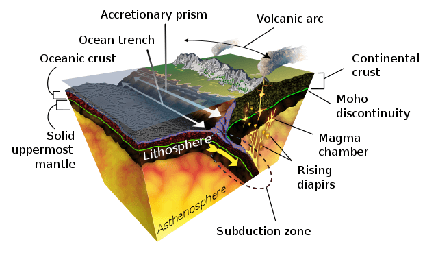
Diagram of the geological process of subduction.