The Pacific Plate: The Giant of Global Tectonics
The Pacific Plate, Earth's largest tectonic plate, dominates nearly one-third of the planet's surface beneath the Pacific Ocean. This massive oceanic plate drives many of the world's most spectacular geological phenomena, demonstrating the profound influence of plate tectonics on global geology.
 via Wikimedia Commons")
Oceanic Dominance: How the Pacific Plate Shapes Global Geology
The Pacific Plate, Earth's largest tectonic plate, covers approximately 103.3 million square kilometers (39.9 million square miles) and dominates nearly one-third of the planet's surface beneath the Pacific Ocean. This massive oceanic plate drives many of the world's most spectacular geological phenomena, from the Ring of Fire's volcanic chains to Hawaii's hotspot islands, demonstrating the profound influence of plate tectonics on global geology.
Structure and Composition
The Pacific Plate consists entirely of oceanic crust with ages ranging from near-zero at active spreading ridges to approximately 180 million years in the western Pacific. This age distribution reflects the plate's formation through continuous seafloor spreading and its gradual westward and northward motion over geological time.
The plate's thickness varies from 6 kilometers (3.7 miles) at young spreading centers to over 100 kilometers (62 miles) in older regions where the thermal lithosphere has thickened through cooling. This variation influences the plate's behavior at convergent boundaries, with older, denser portions more readily subducting than younger, more buoyant areas.
Numerous seamount chains and oceanic plateaus dot the Pacific Plate's surface, created by hotspot volcanism as the plate moved over stationary mantle plumes. The Hawaiian-Emperor seamount chain represents the most famous example, extending over 6,000 kilometers (3,730 miles) from the currently active Hawaiian hotspot to the Aleutian Trench.
Eastern Boundary: The East Pacific Rise System
The Pacific Plate's eastern boundary is defined by the East Pacific Rise system, one of the world's fastest-spreading mid-oceanic ridges. Spreading rates reach 150-180 millimeters (5.9-7.1 inches) per year along certain segments, resulting in extensive zones of active volcanism and hydrothermal activity.
The rise system exhibits complex geometry, featuring numerous transform faults that offset spreading segments. Major fracture zones, including the Mendocino, Murray, and Molokai fracture zones, extend thousands of kilometers westward from the rise, creating linear topographic features that influence oceanic circulation and sediment distribution.
The Galápagos Triple Junction, where the Pacific, Nazca, and Cocos plates meet, represents a particularly complex portion of the eastern boundary. This junction migrates northward as spreading rates change, demonstrating the dynamic nature of plate boundary evolution.
Western Boundary: The Ring of Fire
The Pacific Plate's western and northern boundaries form a significant portion of the famous Ring of Fire, a horseshoe-shaped zone of intense volcanic and seismic activity. This boundary system includes some of Earth's most active subduction zones, where the Pacific Plate descends beneath surrounding continental and oceanic plates.
The Japan Trench, Mariana Trench, and Philippines Trench represent major segments where the Pacific oceanic lithosphere subducts beneath the Eurasian and Philippine Sea plates. The Mariana Trench contains Earth's deepest point, Challenger Deep, reaching 10,994 meters (36,070 feet) below sea level.
Subduction along these trenches generates extensive volcanic arc systems, including Japan, the Philippines, and the Mariana Islands. The process also produces Earth's most powerful earthquakes, including the 2011 Tōhoku earthquake (M 9.1) that triggered a devastating tsunami.
Northern Boundary: Transform Complexity
The northern boundary creates one of the world's longest transform fault systems, extending from the Mendocino Triple Junction off the coast of California to the Aleutian Trench in Alaska. The San Andreas Fault system represents the most studied portion, accommodating approximately 50 millimeters (2.0 inches) per year of right-lateral motion.
The Queen Charlotte Fault continues the transform system northward along the British Columbia and Alaska coasts. This fault generates significant seismic activity, including the 2012 Haida Gwaii earthquake (M 7.8), one of the largest recorded earthquakes in Canada.
The Aleutian Trench marks the transition from transform to convergent motion, where the Pacific Plate subducts beneath the North American Plate. This subduction drives the Aleutian volcanic arc, which contains over 50 active volcanoes across the Alaska Peninsula and Aleutian Islands.
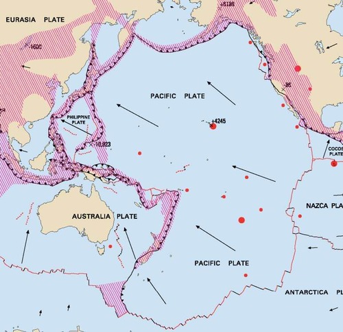
Map depicting the Pacific Plate boundaries and relative motion.
Hotspot Systems and Intraplate Volcanism
The Pacific Plate hosts numerous hotspot systems that create linear volcanic chains as the plate moves over stationary mantle plumes. These systems provide crucial evidence for the directions and velocities of plate motion over geological time.
The Hawaiian hotspot currently underlies the Big Island of Hawaii, generating continuous volcanic activity at Kilauea and Mauna Loa volcanoes. As the Pacific Plate moves northwest at 32-35 millimeters (1.3-1.4 inches) per year, it carries older volcanoes away from the hotspot, creating the Hawaiian Island chain.
The Louisville hotspot created a parallel seamount chain in the southwestern Pacific, while the Society Islands hotspot formed Tahiti and its surrounding islands. The Marquesas hotspot and several other systems contribute to the formation of additional volcanic chains, which record the complex motion history of the Pacific Plate.
Interactions with Latin American Plates
Along the Americas, the Pacific Plate interacts with several plates that are relevant to the Latin America and Caribbean region. Off Mexico's coast, the Pacific Plate meets the North American Plate along the San Andreas transform system, while further south it encounters the Rivera Plate and Cocos Plate along spreading ridges and transform faults.
The East Pacific Rise segments between the Pacific and Nazca plates create new oceanic crust that eventually subducts beneath South America, driving Andean volcanism and mountain building. This connection illustrates how the dynamics of the Pacific Plate influence geological processes thousands of kilometers away.
The Pacific Plate's motion also affects global sea level and ocean circulation patterns, indirectly influencing climate conditions throughout the Americas. Changes in Pacific Plate spreading rates can alter oceanic heat transport and atmospheric circulation patterns.
Seismic Activity and Natural Hazards
The Pacific Plate's boundaries generate approximately 80% of the world's large earthquakes, reflecting the intense tectonic activity along its margins. Subduction zones are responsible for the largest earthquakes, including several magnitude nine or greater events in recent decades.
The 2004 Sumatra-Andaman earthquake (M 9.1-9.3) and the 2011 Tōhoku earthquake demonstrate the devastating potential of earthquakes on the Pacific margin. These events generated tsunamis that caused casualties and damage across the entire Pacific basin, highlighting the interconnected nature of Pacific Plate tectonics.
Transform faults along the plate's margins generate frequent moderate to large earthquakes. The San Andreas Fault system poses continuing seismic hazards to California's population, while similar risks exist along other Pacific Plate transform boundaries.
Economic and Resource Implications
The Pacific Plate's geological processes create significant economic opportunities and challenges. Seafloor spreading along the East Pacific Rise generates extensive hydrothermal systems that concentrate valuable metals, including copper, zinc, gold, and rare Earth elements.
Hotspot volcanism creates valuable resources, including geothermal energy, in Hawaii and other Pacific islands. Iceland, though not on the Pacific Plate, demonstrates the potential for hotspot-related geothermal development that could be applied to Pacific hotspot locations.
However, Pacific Plate tectonics also generates substantial natural hazard risks that affect economic development throughout the Pacific region. Earthquake and tsunami hazards require extensive mitigation investments, while volcanic activity can disrupt aviation and tourism.
Climate and Environmental Connections
The Pacific Plate's vast size and its significant geological activity have a profound influence on global climate systems. The plate's motion affects oceanic circulation patterns, including the critical thermohaline circulation that redistributes heat globally.
Volcanic activity associated with the Pacific Plate boundaries occasionally injects large quantities of gases and particles into the atmosphere, influencing global climate. The 1991 Mount Pinatubo eruption in the Philippines temporarily cooled global temperatures by approximately 0.5°C (0.9°F) for several years.
The Pacific Plate's hotspot systems create unique ecosystems on oceanic islands. Hawaii's endemic species, including the Hibiscadelphus giffardianus (Hau kuahiwi), evolved in isolation on hotspot-created islands. Similar evolutionary processes occur throughout the Pacific, creating extraordinary biological diversity on oceanic islands.
Future Evolution and Global Implications
Current Pacific Plate motions indicate continued subduction along the western margins and ongoing hotspot volcanism throughout the Pacific Basin. The plate's northwest motion relative to North America ensures continued transform faulting along the San Andreas system and related structures.
Changes in the Pacific Plate's spreading rates or direction of motion could significantly impact global tectonics. Alterations in subduction rates along Pacific margins would influence volcanic activity, earthquake frequency, and mountain-building processes worldwide.
The Pacific Plate exemplifies how large tectonic plates integrate global geological systems through far-reaching influences on volcanism, seismicity, climate, and biological evolution. Its continuing motion drives many of Earth's most dynamic geological processes and will continue shaping global geology for millions of years to come.
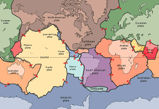
Map illustrating the major tectonic plates of the world.