The Geography of Puerto Rico: A Comprehensive Analysis
Puerto Rico is one of the Caribbean's most geographically diverse and strategically important territories. Situated in the northeastern Caribbean Sea, its landscape features dramatic differences, from mountainous interiors to coastal plains, forming a complex mosaic of ecosystems and climate zones.


 - Vieques, PR - by sarowen, CC BY-NC-ND 2.0, https://www.flickr.com/photos/sarowen/13858726873")
 https://www.flickr.com/photos/spi/2415589046")
Island Geography: The Physical and Human Landscape of Puerto Rico
Puerto Rico, officially known as the Commonwealth of Puerto Rico (Estado Libre Asociado de Puerto Rico), represents one of the Caribbean's most geographically diverse and strategically positioned territories. Located in the northeastern Caribbean Sea, this unincorporated U.S. territory encompasses the main island of Puerto Rico, along with several smaller inhabited islands, most notably Vieques and Culebra, as well as numerous uninhabited cays. Vieques lies 11 kilometers (7 miles) southeast of the main island, while Culebra sits 27 kilometers (17 miles) east of Puerto Rico's mainland coast. Covering approximately 9,104 square kilometers (3,515 square miles), Puerto Rico's geography encompasses dramatic topographical variations, from mountainous interiors to coastal plains, creating a complex mosaic of ecosystems and climatic zones that have profoundly shaped human settlement patterns and economic development throughout its history.
Physical Geography
Location and Boundaries
Puerto Rico occupies a critical position within the Greater Antilles archipelago, situated approximately 1,600 kilometers (1,000 miles) southeast of Miami, Florida, and 80 kilometers (50 miles) east of the Dominican Republic. The island lies between 17°52' and 18°31' North latitude and 65°13' and 67°57' West longitude, placing it firmly within the tropical zone. The Puerto Rico Trench, situated approximately 120 kilometers (75 miles) north of the island, is one of the deepest parts of the Atlantic Ocean, reaching depths exceeding 8,600 meters (28,200 feet) and marking the tectonic boundary between the North American Plate and the Caribbean Plate.
Topography and Geology
The island's topography reflects its complex geological history, characterized by three distinct physiographic regions. The Cordillera Central, also known as the Central Mountain Range, forms the backbone of Puerto Rico, extending east-west across the island's interior and reaching its highest elevation at Cerro de Punta, which stands 1,338 meters (4,390 feet) above sea level. This mountain system consists primarily of volcanic rocks from the Cretaceous period, interspersed with intrusive igneous formations that have created the island's most rugged terrain.
Northern Puerto Rico features an extensive karst region, where limestone bedrock has been sculpted by millions of years of chemical weathering to create one of the world's most spectacular karst landscapes. This region encompasses approximately 28% of the island's total area and includes notable features such as the Camuy Cave System, mogotes (haystack hills), and numerous cenotes and underground rivers. The Río Camuy, which flows through this karst terrain, has carved extensive underground passages, including chambers large enough to accommodate entire city blocks.
The southern coastal plains contrast sharply with the northern karst, consisting of alluvial deposits and marine terraces that create relatively flat terrain extending inland for distances ranging from 5 to 25 kilometers (3 to 15 miles). These plains, particularly in the Ponce and Guayama regions, have historically supported extensive agricultural development due to their fertile soils and favorable drainage characteristics.
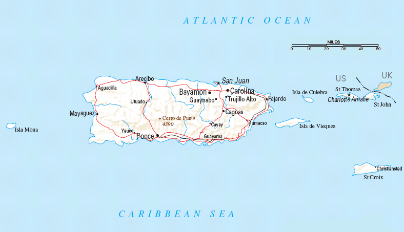
Map of Puerto Rico.
Climate and Weather Patterns
Puerto Rico experiences a tropical marine climate characterized by remarkably stable temperatures throughout the year, with mean temperatures varying less than 3°C (5°F) between the warmest and coolest months. Coastal areas typically experience temperatures ranging from 22°C to 30°C (72°F to 86°F), while mountainous regions can be 5°C to 8°C (9°F to 14°F) cooler, occasionally dropping below 15°C (59°F) at the highest elevations during winter months.
The island's precipitation patterns reflect significant orographic effects, with the northeastern slopes of the Cordillera Central receiving upwards of 4,000 millimeters (157 inches) of rainfall annually. In contrast, the southwestern coastal areas, situated in a pronounced rain shadow, may receive less than 750 millimeters (30 inches) of precipitation per year. El Yunque National Forest, located in the northeastern mountains, represents one of the wettest areas, where trade wind moisture condenses against the mountain slopes to create near-constant cloud cover and frequent precipitation.
Hurricane season, extending from June through November, poses the most significant meteorological threat to Puerto Rico. The island's position within the primary Atlantic hurricane corridor makes it vulnerable to both direct strikes and the peripheral effects of major storms. Historical records indicate that Puerto Rico experiences a direct hurricane impact approximately once every seven to ten years, with major hurricanes (Category 3 or higher) occurring roughly once every fifteen to twenty years.
Hydrology
Puerto Rico's hydrological systems reflect the island's topographical complexity and precipitation patterns. The island contains over 50 rivers, most of which originate in the Cordillera Central and flow radially toward the coast. The Río Grande de Loíza, extending approximately 65 kilometers (40 miles) from its headwaters to the Atlantic Ocean, represents Puerto Rico's longest river and drains the largest watershed, encompassing nearly 1,300 square kilometers (500 square miles).
The karst region's hydrology presents unique characteristics, with numerous rivers disappearing underground only to reemerge kilometers away as springs. The Río Camuy system exemplifies this phenomenon, as it flows underground for significant distances through limestone caverns before emerging at coastal springs. These underground water systems provide crucial freshwater resources but also create challenges for water management and pollution control.
Coastal lagoons and estuaries form important transitional ecosystems where freshwater rivers meet the sea. The Laguna Grande in Fajardo and the Bahía Bioluminiscente in Vieques represent notable examples of these systems, supporting unique ecological communities including mangrove forests and serving as critical nursery areas for marine species.
Biogeography and Ecosystems
Forest Ecosystems
Puerto Rico's diverse topography and climate support multiple forest types, each adapted to specific elevation zones and moisture regimes. The island's original forest cover, which once blanketed approximately 99% of the land surface, has been reduced to roughly 58% due to centuries of human activity; however, reforestation efforts have led to a significant recovery in recent decades.
Tropical rainforests dominate the windward slopes of the mountains, particularly in El Yunque National Forest, where species such as Dacryodes excelsa (tabonuco), Sloanea berteriana (guaraguao), and Prestoea acuminata var. montana (sierra palm) form complex canopy structures. These forests support exceptional biodiversity, including endemic species such as the Puerto Rican parrot (Amazona vittata) and the coquí frog genus Eleutherodactylus, which has diversified into 17 endemic species across the island's various habitats.
Dry forests occur along the southern and southwestern coasts, adapted to the region's semi-arid conditions. These ecosystems, dominated by species such as Bursera simaruba (turpentine tree), Guaiacum officinale (lignum vitae), and various cacti, including Stenocereus fimbriatus, represent some of the Caribbean's most threatened ecosystems due to their limited extent and high development pressure.
Coastal and Marine Ecosystems
Puerto Rico's extensive coastline, measuring approximately 580 kilometers (360 miles), encompasses a diverse array of marine and coastal ecosystems. Coral reefs fringe much of the island's perimeter, supporting exceptional marine biodiversity while providing crucial protection against storm surge and coastal erosion. The island's reefs support over 300 fish species and 40 coral species, including both brain corals (Diploria spp.) and elkhorn coral (Acropora palmata).
Mangrove forests are found in protected coastal areas, particularly along the southern and eastern shores. These ecosystems, dominated by red mangrove (Rhizophora mangle), black mangrove (Avicennia germinans), and white mangrove (Laguncularia racemosa), provide critical ecosystem services including storm protection, carbon sequestration, and nursery habitat for commercially important fish species.
The island's beaches vary considerably in composition and character, ranging from the white coral-sand beaches of Culebra and Vieques to the black volcanic-sand beaches of the northern coast. Culebra, often referred to as "Isla Culebrita" (Little Snake Island), boasts some of the Caribbean's most pristine beaches, including Flamenco Beach, consistently ranked among the world's best beaches for its powdery white sand and crystal-clear turquoise waters. Vieques, the largest of Puerto Rico's offshore islands, is home to the famous Bahía Bioluminiscente (Bioluminescent Bay), where dinoflagellates (Pyrodinium bahamense) create a spectacular blue-green bioluminescence when disturbed. Both islands support important nesting populations of sea turtles, including leatherback turtles (Dermochelys coriacea), hawksbill turtles (Eretmochelys imbricata), and green turtles (Chelonia mydas). Culebra's beaches serve as critical nesting habitats for these endangered species.
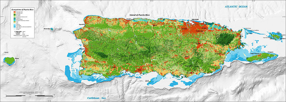
Map of the ecosystems of Puerto Rico.
Human Geography
Population Distribution and Urbanization
Puerto Rico's population of approximately 3.2 million people exhibits a highly uneven distribution, reflecting both historical settlement patterns and contemporary economic opportunities. The San Juan Metropolitan Area, encompassing the municipalities of San Juan, Bayamón, Carolina, Cataño, Guaynabo, and Trujillo Alto, contains nearly 40% of the island's population within just 5% of its land area, creating one of the Caribbean's highest population densities at over 1,500 people per square kilometer (3,900 people per square mile).
This urban concentration reflects Puerto Rico's transition from a predominantly rural, agricultural society to an urbanized, industrial economy during the mid-20th century. The Operation Bootstrap industrialization program, initiated in the 1940s, catalyzed rapid urban growth as manufacturing jobs drew rural populations to coastal cities. Today, over 93% of Puerto Rico's population lives in urban areas, making it one of the most urbanized territories in the Caribbean.
Secondary urban centers have developed around Ponce in the south, Mayagüez in the west, and Arecibo in the north, each serving as regional economic and administrative hubs. These cities typically occupy coastal locations that facilitated historical trade connections while providing access to relatively flat terrain suitable for urban expansion.
Economic Geography
Puerto Rico's economy reflects its unique political status as a U.S. territory, resulting in economic patterns that are distinct from those of both independent Caribbean nations and U.S. states. The island's strategic location has historically made it a critical hub for Caribbean trade and military operations, while its relationship with the United States has provided access to mainland markets and federal programs.
Manufacturing represents the dominant economic sector, contributing approximately 45% of the gross domestic product. The pharmaceutical industry has become particularly significant, with companies such as Pfizer, Johnson & Johnson, and Bristol-Myers Squibb operating major facilities that produce medications for both U.S. and international markets. These industries have clustered primarily in the northern coastal municipalities, taking advantage of port facilities, airport access, and proximity to San Juan's business services.
Agriculture, although historically dominant, now contributes less than 1% to the GDP; yet, it remains culturally and environmentally significant. Coffee cultivation continues in the mountainous interior, particularly around Adjuntas and Jayuya, where elevation and climate create ideal growing conditions for Coffea arabica. Sugarcane, once the island's dominant crop, has largely disappeared from the landscape, though some production continues in the southern coastal plains.
Tourism has emerged as an increasingly important economic sector, leveraging Puerto Rico's natural beauty, cultural heritage, and convenient access for U.S. travelers. The industry generates approximately $3.8 billion annually and supports nearly 80,000 jobs, with major concentrations in San Juan's historic district, the El Yunque region, and the islands of Vieques and Culebra.
Transportation and Infrastructure
Puerto Rico's transportation infrastructure reflects both its island geography and its integration with U.S. systems. The island maintains approximately 26,000 kilometers (16,000 miles) of roads, including a limited-access highway system that connects major urban centers. The autopistas (expressways) form the backbone of this system, with PR-52 connecting San Juan to Ponce and PR-22 providing access to the western regions.
Luis Muñoz Marín International Airport in San Juan serves as the Caribbean's busiest airport and a major hub for connections throughout the region. The facility handles over 9 million passengers annually and offers direct service to more than 30 U.S. cities, catering to both business travelers and tourists. Regional airports in Ponce, Mayagüez, and Aguadilla provide additional connectivity and serve smaller aircraft operations.
Maritime transportation remains crucial for Puerto Rico's economy, with the Port of San Juan ranking among the busiest container ports in the Caribbean. The port handles over 1.5 million twenty-foot equivalent units (TEUs) annually, serving as a transshipment hub for cargo moving throughout the Caribbean basin. The island's dependence on imported goods, including approximately 85% of its food supply, makes port operations critical to daily life.
Environmental Challenges and Conservation
Puerto Rico faces significant environmental challenges that reflect both its tropical island geography and its densely populated areas. Deforestation, although it has been reversed in recent decades, has had lasting impacts on watershed function and the habitats of species. The island has lost several endemic species, including the Puerto Rican ground sloth (Acratocnus odontrigonus) and various bird species, while others remain critically endangered.
Climate change poses increasing threats through sea level rise, changing precipitation patterns, and intensifying hurricanes. Coastal communities face particular vulnerability, with approximately 13% of the population living within areas at risk from a one-meter (3.3-foot) sea level rise. The island's coral reefs have experienced significant bleaching events, with some regions losing over 80% of coral cover during the past three decades.
Conservation efforts have achieved notable successes, including the establishment of El Yunque National Forest as the only tropical rainforest in the U.S. National Forest system and the designation of numerous other protected areas. The Puerto Rico Planning Board has implemented coastal zone management programs, while various organizations work to restore native species populations and protect critical habitats.
Conclusion
Puerto Rico's geography represents a complex interplay of physical processes, biological diversity, and human adaptation, creating one of the Caribbean's most distinctive landscapes. The island's position at the intersection of major tectonic plates has generated diverse topography, from towering peaks to extensive karst formations, while its tropical location supports exceptional biodiversity within relatively compact boundaries. Human settlement patterns reflect both environmental opportunities and constraints, with urban concentration along favorable coastal locations and agricultural activities adapted to elevation and climate zones.
Understanding Puerto Rico's geography remains essential for addressing contemporary challenges, including sustainable development, environmental conservation, and climate change adaptation. The island's experience as a densely populated tropical territory provides valuable insights for similar regions worldwide, while its unique political status creates both opportunities and constraints for geographic research and environmental management. As Puerto Rico continues to evolve in the 21st century, its geography will undoubtedly continue to shape the opportunities and challenges that its people and ecosystems face.