Vieques and Culebra: Puerto Rico's Eastern Islands
Vieques and Culebra, two islands located east of Puerto Rico's main island, are among the Caribbean's most pristine and ecologically significant territories. These islands offer an extraordinary combination of unspoiled natural beauty, complex historical narratives, and unique Caribbean ecosystems.

 - Vieques, PR - by sarowen, CC BY-NC-ND 2.0, https://www.flickr.com/photos/sarowen/13858726873")


 - Vieques, PR - by sarowen, CC BY-NC-ND 2.0, https://www.flickr.com/photos/sarowen/13858681343")

The Passage Islands: A Comprehensive Study of Vieques and Culebra
Vieques and Culebra, two remarkable islands lying east of Puerto Rico's main island, represent some of the Caribbean's most pristine and ecologically significant territories. While sometimes incorrectly referred to as the "Spanish Virgin Islands," these islands are integral municipalities of Puerto Rico and therefore part of the United States territory. Their designation as "Passage Islands" more accurately reflects their geographical position in the Virgin Passage, the strait separating Puerto Rico from the U.S. Virgin Islands. Together, these islands offer visitors an extraordinary combination of unspoiled natural beauty, complex historical narratives, and unique Caribbean ecosystems that distinguish them from their more developed neighbors.
Geographical Setting and Physical Characteristics
Location and Size
Vieques and Culebra occupy strategic positions in the northeastern Caribbean Sea, serving as geographical stepping stones between Puerto Rico and the Virgin Islands archipelago. Vieques, the larger of the two islands, covers 348 square kilometers (134 square miles) and lies approximately 11 kilometers (7 miles) southeast of Puerto Rico's main island. The island measures roughly 34 kilometers (21 miles) in length and 6.4 kilometers (4 miles) at its widest point, creating an elongated shape that runs generally east-west.
Culebra, significantly smaller at 30 square kilometers (12 square miles), sits 27 kilometers (17 miles) east of mainland Puerto Rico and 19 kilometers (12 miles) north of Vieques. Its more compact, roughly circular form contrasts with Vieques' elongated profile. Both islands are surrounded by numerous smaller cays and islets, including Culebrita, Cayo Norte, Cayo Luis Peña, and Cayo de Tierra, which collectively add to the ecological diversity and maritime complexity of the region.
Topography and Geology
The topographical characteristics of both islands reflect their geological origins within the Greater Antilles arc system. Vieques exhibits gently rolling terrain punctuated by modest hills, with its highest elevation at Cerro de Punta (Monte Pirata) reaching 301 meters (988 feet) above sea level. The island's landscape consists primarily of dry forest and coastal plain environments, with the southern coast featuring dramatic limestone cliffs and the northern shores characterized by sandy beaches and shallow bays.
Culebra presents more varied topography despite its smaller size, with Mount Resaca rising to 195 meters (640 feet) as the island's highest point. The island's geological composition comprises both volcanic and sedimentary rocks, resulting in diverse soil types that support distinct vegetation communities. Culebra's coastline is notably irregular, featuring numerous bays, coves, and peninsulas that create exceptional marine habitats and some of the Caribbean's most spectacular beaches.
Climate and Environmental Conditions
Both islands experience a tropical maritime climate characterized by consistent temperatures, trade wind moderation, and distinct wet and dry seasons. Average temperatures range from 24°C to 29°C (75°F to 84°F) throughout the year, with minimal seasonal variation. The trade winds provide natural cooling, helping to moderate humidity levels and making the climate generally pleasant, despite its tropical latitude.
Precipitation patterns follow typical Caribbean seasonality, with a drier period from December to April, receiving approximately 800-1,000 millimeters (31-39 inches) annually, while the wetter season from May to November can bring 1,200-1,500 millimeters (47-59 inches). Both islands lie within the Atlantic hurricane corridor, making them vulnerable to tropical storms and hurricanes, particularly during the peak season from August through October.
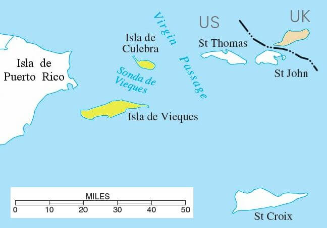
Vieques and Culebra location map.
Unique Ecosystems and Biodiversity
Terrestrial Environments
The islands support diverse terrestrial ecosystems, which are adapted to their subtropical dry forest climate zone. Vieques contains extensive dry forest communities dominated by species such as Bursera simaruba (turpentine tree), Pisonia subcordata (smooth four o'clock), and various cacti, including Opuntia species. These forests provide critical habitat for numerous bird species, including the endemic Vireo latimeri (Puerto Rican vireo) and migrant species that use the islands as stopover points during trans-Caribbean flights.
Culebra's vegetation reflects its more varied topography, with dry forests on the hills transitioning to coastal scrublands and mangrove systems in protected bays. The island supports several plant species of conservation concern, including Cordia bellonis and Eugenia xerophytica, both of which are endemic to the Puerto Rico bank.
Marine and Coastal Ecosystems
The surrounding waters support exceptionally diverse marine ecosystems, including some of the Caribbean's healthiest coral reefs. The reefs around both islands host over 250 fish species and 40 coral species, with particularly well-developed elkhorn coral (Acropora palmata) and staghorn coral (Acropora cervicornis) formations in areas protected from major storm damage.
Seagrass beds, dominated by Thalassia testudinum (turtle grass) and Syringodium filiforme (manatee grass), provide crucial feeding areas for green sea turtles (Chelonia mydas) and habitat for numerous fish species. These underwater meadows also serve important ecological functions, including sediment stabilization and carbon sequestration.
Bioluminescent Phenomena
Vieques hosts one of the world's most spectacular bioluminescent bays, Bahía Mosquito (Mosquito Bay), where dinoflagellates Pyrodinium bahamense create extraordinary blue-green luminescence when disturbed. This phenomenon occurs due to the bay's unique environmental conditions, including optimal salinity levels, nutrient availability, and protection from oceanic flushing. The bay contains an estimated 700,000 dinoflagellates per gallon of water, making it the brightest bioluminescent bay currently known to science.
Historical Development and Cultural Heritage
Pre-Columbian and Colonial Periods
Archaeological evidence suggests that the Taíno people inhabited both islands for centuries prior to European contact. The Taínos established seasonal fishing camps and utilized the islands' resources for tool-making, particularly the high-quality chert deposits found on both islands. European contact began with Christopher Columbus's second voyage in 1493, after which the islands fell under Spanish colonial administration as dependencies of the Spanish colony of Puerto Rico.
During the colonial period, both islands remained sparsely populated, serving primarily as sources of timber and livestock grazing areas, and occasionally as refuges for ships during storms. Their numerous hidden coves and strategic location made them popular bases for privateers and smugglers operating in the Virgin Passage, leading to occasional conflicts with Spanish authorities.
American Military Period
The Spanish-American War of 1898 brought both islands under U.S. control, along with Puerto Rico. However, the most transformative period began during World War II when the U.S. Navy established major training facilities on both islands. Beginning in 1941, the Navy used portions of both islands for bombing practice, naval gunfire exercises, and amphibious landing operations.
The military presence had a profound impact on both islands' environments and communities. On Culebra, the Navy controlled approximately 80% of the island's land area, displacing residents and limiting economic development. Similar patterns occurred on Vieques, where the Navy controlled approximately 73% of the island, including the eastern and western thirds.
Local resistance to military activities intensified over decades, culminating in sustained civil disobedience campaigns. The death of civilian security guard David Sanes in 1999 during military exercises on Vieques galvanized international attention and accelerated demands for military withdrawal. The Navy ceased operations on Culebra in 1975 and ended activities on Vieques in 2003, transferring lands to the U.S. Fish and Wildlife Service.
Contemporary Economic Landscape
Tourism Development
Following military withdrawal, both islands experienced significant economic transitions, with tourism emerging as the primary economic driver. The islands' pristine beaches, clear waters, and laid-back atmospheres have attracted growing numbers of visitors seeking alternatives to more developed Caribbean destinations.
Culebra has developed a reputation among beach enthusiasts, with Flamenco Beach consistently ranking among the world's most beautiful beaches. The beach's powdery white sand, derived from coral and shell fragments, and crystal-clear turquoise water create an almost archetypal tropical paradise setting. Tourism infrastructure remains deliberately modest, with regulations limiting large-scale development to preserve the island's natural character.
Vieques has attracted eco-tourists and adventure travelers drawn to its bioluminescent bay, extensive wildlife refuge, and more diverse landscape. The island offers a broader range of accommodations, from rustic guesthouses to boutique eco-lodges, while maintaining restrictions on large resort development.
Sustainable Development Challenges
Both islands face complex challenges in striking a balance between economic development and environmental conservation. Limited freshwater resources, waste management difficulties, and transportation constraints create ongoing challenges for residents and businesses. The islands' isolation requires most goods to be imported from the mainland of Puerto Rico, which increases costs and limits economic diversification opportunities.
Recent initiatives have focused on sustainable tourism practices, renewable energy development, and support for local agriculture and fishing. Solar energy projects have reduced dependence on imported fossil fuels, while organic farming initiatives seek to increase local food production and reduce import dependence.
Environmental Conservation and Management
Wildlife Refuges and Protected Areas
The Vieques National Wildlife Refuge, established in 2003 on former Navy lands, encompasses approximately 7,300 hectares (18,000 acres) or roughly 55% of the island. The refuge protects critical habitat for numerous species, including brown pelicans (Pelecanus occidentalis), magnificent frigatebirds (Fregata magnificens), and four species of sea turtles that nest on the island's beaches.
Culebra National Wildlife Refuge, established in 1909, was one of the first wildlife refuges created in the Caribbean. The refuge encompasses 23 offshore cays and portions of Culebra's coastline, safeguarding approximately 600 hectares (1,480 acres) of marine and terrestrial habitats. These areas serve as critical nesting sites for seabirds, including brown boobies (Sula leucogaster) and red-billed tropicbirds (Phaethon aethereus).
Marine Conservation Efforts
The waters surrounding both islands have been designated as critical habitat for endangered species, including the hawksbill sea turtle (Eretmochelys imbricata) and the elkhorn coral. Collaborative efforts between federal agencies, local organizations, and academic institutions focus on coral reef restoration, sea turtle monitoring, and marine education programs.
Recent initiatives include coral nursery projects, where fragments of healthy coral are grown in underwater nurseries before being transplanted to degraded reef areas. These efforts have shown promising results in areas where environmental conditions remain suitable for coral growth.
Contamination Remediation
Former military sites on both islands require ongoing environmental remediation to address contamination from decades of military activities. On Vieques, the U.S. Environmental Protection Agency has designated portions of the former bombing range as Superfund sites, requiring comprehensive cleanup of unexploded ordnance and chemical contamination.
Remediation efforts employ various techniques, including soil excavation, groundwater treatment, and habitat restoration. These complex projects require careful coordination to protect sensitive ecosystems while addressing contamination concerns that affect both human health and environmental quality.
Cultural Identity and Community Life
Demographics and Settlement Patterns
Vieques maintains a permanent population of approximately 8,200 residents, concentrated primarily in the towns of Isabel Segunda and Esperanza. The population reflects Puerto Rico's broader demographic patterns, with predominantly Hispanic heritage and strong cultural connections to mainland Puerto Rico, though island life has created distinct local traditions and practices.
Culebra's smaller population of approximately 1,800 residents creates a more intimate community atmosphere, with most residents living in and around the town of Dewey. The island's size and isolation have fostered strong community bonds and traditions of self-reliance that distinguish Culebra from larger Puerto Rican communities.
Language and Cultural Practices
Spanish serves as the primary language on both islands, though English proficiency is widespread due to tourism and historical U.S. connections. Local dialects incorporate maritime terminology and expressions unique to island life, reflecting the communities' close relationships with the sea.
Cultural celebrations blend Puerto Rican traditions with local innovations. Vieques' Carnival in July features colorful parades, traditional music, and regional cuisine, while Culebra hosts various festivals celebrating fishing traditions and patron saints. These events serve important social functions, maintaining cultural continuity and community cohesion.
Arts and Crafts Traditions
Both islands support vibrant arts communities that draw inspiration from natural beauty and maritime heritage. Local artists work in a variety of media, from traditional Puerto Rican crafts to contemporary installations that address environmental themes and historical experiences.
Culebra's artistic community has gained recognition for its environmental art projects, which highlight conservation messages while celebrating the island's natural beauty. Vieques has developed a reputation for community-based art initiatives that address historical trauma while promoting healing and cultural preservation.
Future Prospects and Challenges
Sustainable Tourism Balance
Both islands face ongoing challenges in managing tourism growth while preserving environmental quality and community character. Recent increases in visitor numbers have strained infrastructure and raised concerns about environmental impacts, particularly on fragile coastal ecosystems.
Sustainable tourism initiatives focus on visitor education, capacity limits, and support for local businesses. These efforts seek to ensure that tourism benefits local communities while minimizing negative environmental and cultural impacts.
Climate Change Adaptation
Rising sea levels, changing precipitation patterns, and potentially more intense hurricanes pose significant challenges for these low-lying islands. Adaptation strategies include coastal protection measures, freshwater conservation, and infrastructure improvements designed to mitigate the impact of extreme weather events.
Community-based adaptation initiatives emphasize the importance of local knowledge and participation in developing resilience strategies. These approaches recognize that successful adaptation requires integration of environmental, economic, and social considerations.
Economic Diversification
While tourism provides essential economic benefits, both islands seek opportunities for economic diversification that align with environmental conservation goals. Potential areas include sustainable agriculture, renewable energy production, and marine-based industries that support conservation objectives.
Educational initiatives focus on developing local capacity for environmental management, sustainable business practices, and cultural preservation. These programs recognize that long-term sustainability requires strong local leadership and community engagement.
Conclusion
Vieques and Culebra represent extraordinary examples of Caribbean islands that have maintained remarkable natural beauty and ecological integrity despite complex historical experiences. Their status as integral parts of Puerto Rico, rather than separate "Spanish Virgin Islands," reflects their deep cultural and administrative connections to the broader Puerto Rican experience while acknowledging their unique geographical and environmental characteristics.
The islands' transformation from military training areas to conservation showcases and sustainable tourism destinations demonstrates the possibilities for positive change when communities, governments, and conservation organizations work collaboratively toward shared goals. Their ongoing challenges—balancing development with conservation, addressing historical environmental damage, and adapting to climate change—reflect broader issues facing small island communities throughout the Caribbean.
As Vieques and Culebra continue to evolve in the 21st century, their experiences offer valuable insights for sustainable development in island environments. Their success in preserving natural beauty while supporting local communities offers hope that small islands can maintain their unique characters while adapting to contemporary challenges. These remarkable islands serve as reminders that some of the Caribbean's greatest treasures often lie in its lesser-known corners, where natural beauty and human resilience combine to create truly special places.