The Geography of Panama: Bridge Between Continents and Seas
Panama serves as a narrow land bridge connecting North and South America, separating the Atlantic and Pacific Oceans. Its unique location has shaped significant biodiversity, diverse climates, species migration, and human development, making it a vital link for ecosystems and global trade routes.


")


, https://www.flickr.com/photos/kucinski/7721855242/in/photostream/")
Panama: The Transcontinental Isthmus and Its Geographic Complexity
Panama, officially the Republic of Panama, occupies a unique and strategically vital position as the southernmost country of Central America and the narrowest point of the American continental landmass. Covering approximately 75,517 square kilometers (29,157 square miles), Panama serves as the crucial land bridge connecting North and South America while separating the Atlantic and Pacific Oceans. This extraordinary geographic position has profoundly influenced the nation's physical characteristics, biodiversity, climate patterns, and human development throughout its history.
The country's distinctive S-shaped configuration stretches approximately 772 kilometers (480 miles) from east to west while varying dramatically in width from just 60 kilometers (37 miles) at its narrowest point to 200 kilometers (124 miles) at its widest. Panama is bordered by Costa Rica to the west, Colombia to the east, the Caribbean Sea to the north, and the Pacific Ocean to the south. This strategic location has made Panama a natural corridor for species migration, human movement, and global commerce for millennia.
Panama's geography is characterized by remarkable diversity despite its relatively small size. The country encompasses four primary physiographic regions: the Caribbean Lowlands, the Pacific Lowlands, the Central Mountain Range, and the Eastern Highlands. Each region exhibits distinct topographical features, climatic conditions, and ecological characteristics that contribute to Panama's status as one of the world's most biodiverse countries per unit area.
Physical Geography and Topography
The Central Mountain Range
The Central Mountain Range, known locally as the Cordillera Central, forms the mountainous backbone of Panama, extending from the Costa Rican border eastward to approximately the center of the country. This mountain system represents the southern extension of the Central American Cordillera, encompassing Panama's highest elevations and most rugged terrain.
Volcán Barú, situated in western Panama near the Costa Rican border, is the country's highest point, standing at 3,475 meters (11,401 feet) above sea level. This dormant stratovolcano dominates the landscape of Chiriquí Province, and, on clear days, it offers views of both the Pacific Ocean and the Caribbean Sea from its summit. The mountain's slopes support diverse ecosystems ranging from tropical rainforests at lower elevations to cloud forests and páramo vegetation near the peak.
The Cordillera Central continues eastward through the provinces of Chiriquí, Veraguas, and into Coclé, gradually decreasing in elevation. The Serranía de Tabasará forms a significant subrange within this system, reaching elevations exceeding 1,500 meters (4,921 feet) and serving as an important watershed divide between the Caribbean and Pacific drainage basins.
The Continental Divide traverses the length of the Cordillera Central, separating rivers that flow north to the Caribbean Sea from those that flow south to the Pacific Ocean. This topographical feature has profound implications for climate, vegetation patterns, and human settlement, creating distinct wet and dry sides of the mountains based on prevailing wind patterns and orographic precipitation effects.
The Caribbean Lowlands
The Caribbean Lowlands, or Costa del Caribe, extend along Panama's northern coast from the Costa Rican border to the Colombian frontier. Low-lying terrain, extensive river systems, and dense tropical rainforests characterize this region. Elevations throughout most of the Caribbean Lowlands remain below 200 meters (656 feet) above sea level, creating ideal conditions for the development of complex river networks and extensive wetland systems.
The Caribbean coastal plain varies significantly in width, from less than 10 kilometers (6 miles) in some mountainous areas to over 100 kilometers (62 miles) in the eastern provinces of Colón and the comarcas indígenas. The coastline itself extends for approximately 1,160 kilometers (721 miles) and features numerous bays, lagoons, and river mouths, creating a diverse array of coastal ecosystems.
The region's topography is characterized by extensive alluvial plains formed by sediment deposition from major river systems that flow north from the central mountains. These plains support some of Panama's most productive agricultural areas, particularly for banana cultivation, rice production, and cattle ranching. The Azuero Peninsula, though technically located on the Pacific side, shares many characteristics with the Caribbean Lowlands in terms of its relatively flat terrain and agricultural importance.
Significant river systems draining the Caribbean Lowlands include the Río Tuira in the east, which forms Panama's longest river at approximately 230 kilometers (143 miles), and the Río Chagres, which plays a crucial role in the operation of the Panama Canal. These rivers and their tributaries create extensive floodplains, supporting rich riparian forests that serve as important wildlife corridors.
The Pacific Lowlands
The Pacific Lowlands, or Costa del Pacífico, encompass the southern coastal regions of Panama, extending from the Costa Rican border to the Colombian border. This region exhibits greater topographical diversity than the Caribbean Lowlands, featuring coastal plains, peninsulas, islands, and areas where the central mountains approach close to the Pacific shoreline.
The Pacific coastline extends for approximately 1,700 kilometers (1,056 miles), significantly longer than the Caribbean coast due to the numerous peninsulas, bays, and islands that characterize this region. The Azuero Peninsula represents the most prominent coastal feature, extending southward into the Pacific and creating the Gulf of Panama on its eastern side. This peninsula, with its rolling hills and seasonal dry forests, supports important agricultural activities and distinctive cultural traditions.
The Pearl Islands (Archipiélago de las Perlas) in the Gulf of Panama represent one of the most significant island groups, comprising over 200 islands and islets. The largest island, Isla del Rey, covers approximately 234 square kilometers (90 square miles) and reaches elevations of 206 meters (676 feet). These islands support unique ecosystems and serve as important nesting sites for seabirds and marine turtles.
The Pacific Lowlands are drained by numerous rivers flowing south from the central mountains, including the Río Santa María, Río La Villa, and Río Bayano. These river systems create fertile valleys that support intensive agriculture, particularly rice cultivation, sugarcane production, and cattle ranching.
The Eastern Highlands
The Eastern Highlands, located primarily in Darién Province, represent a distinct geographical region characterized by rugged terrain, dense forests, and relative isolation from the rest of Panama. This region includes portions of the Serranía del Darién, which forms part of the border with Colombia and represents some of the most challenging terrain in Central America.
Cerro Tacarcuna, which reaches 1,875 meters (6,152 feet) above sea level, is the highest point in the Eastern Highlands and forms part of the international border with Colombia. The region's complex topography includes steep-sided valleys, isolated peaks, and extensive plateaus that support some of Panama's most pristine forest ecosystems.
The Eastern Highlands serve as the headwaters for several major river systems, including the upper reaches of the Río Tuira and its tributaries. The region's remoteness and challenging terrain have limited human settlement and economic development, thereby preserving extensive areas of primary forest that support exceptional biodiversity.
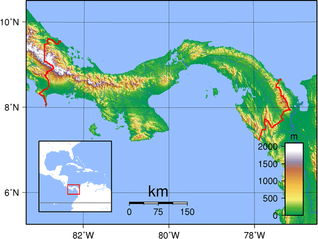
Topographic map of Panama.
Major Water Bodies
Rivers and Drainage Systems
Panama's river systems are divided between the Caribbean and Pacific watersheds, with the continental divide determining the direction of drainage. Despite the country's relatively small size, it supports numerous significant rivers that play crucial roles in transportation, hydroelectric power generation, agriculture, and maintaining its ecosystem.
The Río Tuira, Panama's longest river at approximately 230 kilometers (143 miles), drains much of eastern Panama and flows northward to the Caribbean Sea through an extensive delta system. The river and its tributaries drain an area of approximately 5,500 square kilometers (2,124 square miles) and support important transportation functions for communities in Darién Province that lack road access.
The Río Chagres holds particular significance due to its central role in the operation of the Panama Canal. This river was dammed to create Gatún Lake, which forms a crucial component of the canal system. The Chagres River basin spans approximately 3,340 square kilometers (1,289 square miles) and encompasses some of Panama's most significant protected areas, including Chagres National Park.
On the Pacific side, the Río Bayano represents one of the most important drainage systems, flowing approximately 206 kilometers (128 miles) from its headwaters in the central mountains to the Pacific Ocean. The river has been dammed to create Bayano Lake, which supports hydroelectric power generation and provides water storage for dry season needs.
The Río Santa María, draining the Azuero Peninsula, plays a crucial role in regional agriculture and supports some of Panama's most productive rice-growing areas. The river's seasonal flow patterns reflect the pronounced dry season characteristic of the Pacific Lowlands, with high flows during the wet season and minimal flows during the dry months.
Lakes and Reservoirs
Panama's lakes are primarily artificial, created through dam construction for hydroelectric power generation, water supply, and canal operations. These reservoirs have become significant features of the country's geography, supporting various economic activities and fostering the development of new aquatic ecosystems.
Gatún Lake, created in 1913 as part of the Panama Canal system, covers approximately 425 square kilometers (164 square miles) and represents one of the largest artificial lakes in the world at the time of its construction. The lake reaches maximum depths of approximately 26 meters (85 feet) and serves as a crucial component of the canal's operation, providing the water needed for lock operations and ship transit.
Bayano Lake, formed by the construction of the Bayano Dam in 1976, covers approximately 350 square kilometers (135 square miles) when at full capacity. This reservoir supports Panama's largest hydroelectric facility and plays a vital role in the country's electricity generation. The lake's creation inundated extensive areas of forest and agricultural land, requiring the relocation of several communities.
Alajuela Lake, also known as Madden Lake, was created in 1935 as part of the expanded Panama Canal watershed management system. Covering approximately 50 square kilometers (19 square miles), this reservoir helps regulate water flow in the Chagres River system and provides additional water storage for canal operations.
Coastal Waters and Marine Environments
Panama's extensive coastlines on both the Caribbean Sea and the Pacific Ocean create diverse marine environments that support important fisheries, tourism activities, and transportation functions. The country's marine territories encompass approximately 319,000 square kilometers (123,166 square miles) of territorial waters and exclusive economic zones.
The Gulf of Panama, formed by the Azuero Peninsula and the mainland, represents the largest embayment on Panama's Pacific coast. This gulf supports important commercial fishing activities, particularly for tuna, shrimp, and various coastal species. The gulf's nutrient-rich waters result from upwelling phenomena and river discharge, creating productive marine ecosystems.
The Gulf of Chiriquí, located along Panama's western Pacific coast near the Costa Rican border, encompasses important marine protected areas, including Coiba National Park. This gulf supports exceptional marine biodiversity, including significant populations of whales, dolphins, sharks, and other large marine species.
The Caribbean coast features numerous bays and lagoons, including the extensive Chiriquí Lagoon in Bocas del Toro Province. This lagoon system supports important mangrove ecosystems and serves as a nursery habitat for numerous marine species. The region's coral reefs, though less extensive than those in other Caribbean locations, provide important ecological services and support tourism activities.
Climate and Weather Patterns
Panama's tropical climate is characterized by high temperatures, abundant rainfall, and pronounced seasonal variations in precipitation. The country's location near the equator and its position between two major oceans create complex climate patterns that vary significantly across different regions and elevations.
Regional Climate Variations
The Caribbean coast experiences a tropical rainforest climate with high rainfall throughout the year and minimal seasonal variation in precipitation. Annual rainfall totals typically range from 2,500 to 4,000 millimeters (98 to 157 inches), with some areas receiving over 5,000 millimeters (197 inches) annually. Temperatures remain relatively constant throughout the year, with average daily temperatures ranging from 24°C to 30°C (75°F to 86°F).
The Pacific coast exhibits greater seasonal variation, with a pronounced dry season extending from December to April and a wet season from May to November. Annual rainfall totals on the Pacific side typically range from 1,200 to 2,500 millimeters (47 to 98 inches), significantly less than on the Caribbean coast. The Azuero Peninsula experiences the driest conditions in Panama, with some areas receiving less than 1,000 millimeters (39 inches) of annual rainfall.
The central mountains create significant orographic effects that modify regional climate patterns. Windward slopes facing the Caribbean receive substantially more precipitation than leeward slopes facing the Pacific, creating pronounced rain shadow effects. Elevations above 1,000 meters (3,281 feet) experience cooler temperatures, with average temperatures decreasing by approximately 6°C per 1,000 meters (3.3°F per 1,000 feet) of elevation.
Cloud forests are found at elevations ranging from 1,000 to 2,500 meters (3,281 to 8,202 feet) in areas characterized by persistent cloud cover and high humidity. These ecosystems experience frequent fog and mist, creating unique growing conditions that support exceptional biodiversity and endemic species.
Seasonal Patterns and Extreme Weather
Panama's seasonal patterns are primarily driven by the migration of the Intertropical Convergence Zone and the seasonal positioning of high-pressure systems over the subtropical Atlantic and Pacific. The dry season, known locally as verano, coincides with the northward migration of the ITCZ and the strengthening of the North Atlantic high-pressure system.
During the dry season, trade winds strengthen and carry relatively dry air masses across the isthmus. This period is characterized by clear skies, low humidity, and minimal precipitation, particularly on the Pacific side. The wet season, known as invierno, begins when the ITCZ shifts back toward the equator, bringing moisture-laden air masses and increased convective activity.
Panama is generally less affected by hurricanes than other Caribbean nations due to its southern location; however, the country can still experience impacts from tropical storms and hurricanes, particularly along its Caribbean coast. The hurricane season extends from June to November, with the greatest risk typically occurring between August and October.
El Niño and La Niña phenomena significantly influence Panama's climate patterns, affecting both precipitation amounts and seasonal timing. El Niño events typically bring reduced rainfall and extended dry seasons, while La Niña events often increase precipitation and can lead to flooding in some regions.
Biodiversity and Ecosystems
Panama's position as a biological bridge between North and South America, combined with its diverse climates and topography, has created one of the world's most biodiverse countries relative to its size. The country supports an estimated 10,000 plant species, 1,500 tree species, 978 bird species, 229 mammal species, 226 reptile species, and 164 amphibian species, many of which are endemic to the region.
Forest Ecosystems
Tropical rainforests cover approximately 65% of Panama's territory, representing some of the most diverse and pristine forest ecosystems in Central America. These forests are characterized by high species diversity, complex vertical stratification, and rapid nutrient cycling. The Caribbean slope forests receive abundant rainfall throughout the year and support continuous forest cover from sea level to approximately 1,000 meters (3,281 feet) elevation.
The Darién region supports some of Central America's largest remaining blocks of continuous forest, including areas that have never been significantly disturbed by human activities. These forests support populations of large mammals, including the jaguar (Panthera onca), puma (Puma concolor), Baird's tapir (Tapirus bairdii), and white-lipped peccary (Tayassu pecari). The region also serves as habitat for over 500 bird species, including the harpy eagle (Harpia harpyja), Panama's national bird.
Cloud forests are found at intermediate elevations in the central mountains, characterized by persistent cloud cover, high humidity, and unique plant communities that are adapted to frequent fog and mist. These ecosystems support numerous endemic species and serve as crucial water sources for rivers flowing to both coasts. The Monteverde-type cloud forests of western Panama share many characteristics with similar forests in Costa Rica and support important populations of quetzals (Pharomachrus spp.) and other montane species.
Dry tropical forests primarily occur on the Pacific slope of the Azuero Peninsula and in rain-shadow areas of the central mountains. These forests are characterized by pronounced seasonality, with many trees shedding their leaves during the dry season. Despite their reduced stature compared to rainforests, dry forests support high levels of endemism and unique adaptations to seasonal drought conditions.
Mangrove forests occur along both coasts but are particularly extensive along the Pacific shore, where they cover approximately 1,700 square kilometers (656 square miles). The Gulf of Montijo supports Panama's largest mangrove system, dominated by red mangrove (Rhizophora mangle), black mangrove (Avicennia germinans), white mangrove (Laguncularia racemosa), and buttonwood (Conocarpus erectus). These ecosystems provide crucial nursery habitat for marine species and support important fisheries.
Aquatic Ecosystems
Panama's freshwater ecosystems include rivers, streams, lakes, and wetlands that support diverse assemblages of aquatic species. The country's rivers support approximately 220 freshwater fish species, including several endemic species found nowhere else in the world. The Río Tuira and its tributaries support particularly diverse fish communities, including several species of catfish and characins that represent the northern extent of South American fish distributions.
Gatún Lake and other artificial reservoirs have created new aquatic ecosystems that support both native and introduced species. These lakes provide habitat for numerous bird species, including populations of waterfowl that utilize the reservoirs during seasonal migrations. The creation of these artificial lakes has also allowed some marine species to establish freshwater populations, creating unique ecological situations.
Coastal lagoons and estuaries along both coasts support important populations of waterfowl, wading birds, and marine species during various life stages. The Chiriquí Lagoon in Bocas del Toro Province supports extensive seagrass beds that provide habitat for the West Indian manatee (Trichechus manatus) and numerous fish species.
Marine Ecosystems
Panama's marine ecosystems encompass coral reefs, rocky shores, sandy beaches, and offshore waters, which support an exceptional level of marine biodiversity. The country's position between the Caribbean Sea and the Pacific Ocean creates opportunities for comparison between two distinct marine biogeographic regions.
Caribbean coral reefs, though less extensive than in other parts of the Caribbean, support important populations of reef fish, sea turtles, and other marine species. The Bocas del Toro archipelago is home to Panama's most significant coral reef systems, which support over 200 coral species and numerous endemic fish species.
Pacific marine ecosystems are influenced by seasonal upwelling phenomena that bring nutrient-rich waters to the surface layers, supporting high productivity and important fisheries. Coiba Island and its surrounding waters support exceptional marine biodiversity, including significant populations of large pelagic species such as whale sharks (Rhincodon typus), manta rays (Mobula birostris), and various shark species.
The Pacific coast serves as an important nesting habitat for several sea turtle species, including the olive ridley (Lepidochelys olivacea), leatherback (Dermochelys coriacea), and hawksbill (Eretmochelys imbricata). These species face various conservation challenges, including coastal development, fishing impacts, and the effects of climate change on nesting beaches.
Endemic and Threatened Species
Panama supports numerous endemic species, particularly in isolated mountain regions and island ecosystems. The golden frog (Atelopus zeteki), Panama's national animal, is endemic to the central mountains but faces severe threats from chytrid fungus disease and habitat loss. Conservation efforts include captive breeding programs and habitat protection measures.
The Panamanian night monkey (Aotus zonalis) is endemic to Panama and represents the only nocturnal monkey species in Central America. This species is primarily found in the forest areas of central and eastern Panama, serving as an important indicator of the health of the forest ecosystem.
Many of Panama's bird species are endemic or near-endemic, including several hummingbird species found only in the mountains of western Panama. The country's position along major bird migration routes makes it crucial for numerous migratory species that depend on suitable habitats during their journeys between North American breeding and wintering grounds.
Marine endemism is particularly notable around Coiba Island, where isolation has led to the evolution of unique fish species and subspecies. The island's marine ecosystems support several endemic fish species that are found nowhere else on Earth.
Geological Features and Natural Hazards
Panama's geological history reflects its formation as a relatively young landmass that emerged from the sea approximately 3 million years ago, connecting the North and South American continents and profoundly affecting global ocean circulation patterns. The country's geological complexity results from its position at the intersection of several tectonic plates and its recent geological formation.
Geological History and Structure
Panama's geological foundation consists primarily of volcanic and sedimentary rocks formed during the Cenozoic Era. The country's emergence from the ocean resulted from volcanic activity associated with the subduction of the Nazca Plate beneath the Caribbean Plate, creating the volcanic arc that forms much of Central America.
The central mountains consist primarily of volcanic rocks, including andesites, basalts, and associated pyroclastic deposits formed during millions of years of volcanic activity. These volcanic rocks are interspersed with sedimentary formations, including marine limestones that indicate periods when portions of the current landmass were submerged beneath ancient seas.
The Caribbean and Pacific lowlands consist primarily of sedimentary deposits, including alluvial materials deposited by rivers draining the central mountains. These sediments include both terrestrial deposits formed in river valleys and deltas, as well as marine sediments deposited in coastal areas during periods of higher sea level.
The Azuero Peninsula is one of Panama's oldest geological formations, featuring rocks that date back to the Cretaceous Period. This peninsula contains important mineral deposits, including copper, gold, and other metals that have been exploited since pre-Columbian times.
Volcanic Activity
Panama is home to several active and dormant volcanoes, primarily located in the western provinces near the Costa Rican border. Volcán Barú, the country's highest peak, last erupted approximately 500 years ago and is considered dormant though not extinct. The volcano shows evidence of multiple eruption cycles throughout its history, with volcanic deposits extending across much of western Panama.
The Cordillera Central is home to numerous other volcanic peaks, including Volcán La Yeguada, which has recently exhibited signs of geothermal activity. The region's volcanic history has created fertile soils that support intensive agriculture, particularly coffee production at higher elevations.
Geothermal activity associated with volcanic systems provides potential for renewable energy development, though Panama has not yet extensively developed geothermal power generation. Hot springs are found throughout volcanic regions, indicating that ongoing geothermal processes are present beneath the surface.
Seismic Activity
Panama experiences moderate seismic activity due to its position near the boundary between the Caribbean, Nazca, and South American tectonic plates. The country's seismic activity is generally less intense than that experienced by other Central American nations, but significant earthquakes do occur periodically.
The most seismically active areas include the Caribbean coast, where the interaction between the Caribbean and South American plates creates ongoing tectonic stress. The Pacific coast also experiences seismic activity related to the subduction of the Nazca Plate beneath the Caribbean Plate.
Major historical earthquakes have affected Panama, including events that have caused significant damage to infrastructure and loss of life. The 1991 Limon earthquake, though centered in Costa Rica, caused substantial damage in western Panama and highlighted the region's seismic vulnerability.
Mineral Resources
Panama's mineral resources include gold, copper, silver, and various industrial minerals; however, the country's mining industry remains relatively underdeveloped compared to other Central American nations. The Azuero Peninsula contains significant copper deposits that have been known since pre-Columbian times, when Indigenous peoples extracted and worked copper for tools and ornaments.
Gold deposits occur throughout the central mountains, with both placer and hard-rock deposits present in various locations. Artisanal gold mining has been a practice for centuries, although large-scale commercial mining operations remain limited due to environmental concerns and regulatory constraints.
Industrial minerals, including limestone, sand, and gravel, support construction and cement production activities. The Pacific coast's extensive sandy beaches provide materials for construction, although extraction must be balanced with the need for coastal protection and tourism.
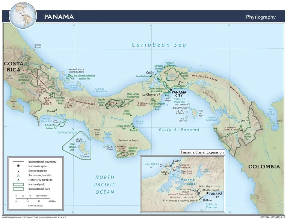
Physiographic map of Panama.
Human Geography and Settlement Patterns
Panama's human geography reflects the profound influence of its unique physical location as a transcontinental bridge and interoceanic passage. The country's population of approximately 4.4 million people is distributed unevenly across its diverse landscapes, with settlement patterns strongly influenced by topography, climate, transportation routes, and economic opportunities.
Population Distribution
The majority of Panama's population is concentrated in the central corridor, extending from Panama City on the Pacific coast to Colón on the Caribbean coast, following the route of the Panama Canal. This corridor, known as the Canal Zone or Central Region, contains approximately 65% of the country's population despite comprising less than 20% of the national territory.
Panama City, the capital and largest urban center, supports over 1.9 million people in its metropolitan area, representing nearly half of the country's total population. The city's location on the Pacific entrance to the Panama Canal has made it the country's primary commercial, financial, and administrative center. The metropolitan area has expanded rapidly in recent decades, incorporating surrounding areas and creating one of Central America's largest urban agglomerations.
The western provinces of Chiriquí and Veraguas support the second-largest population concentrations, with the highland city of David serving as the regional center for western Panama. This region benefits from favorable climate conditions, fertile soils, and strong agricultural economies based on coffee, bananas, and other crops.
The Caribbean provinces generally support lower population densities, with Colón serving as the primary urban center on the Atlantic coast. The city's location at the Caribbean entrance to the Panama Canal has made it a vital transportation and commercial hub, although it faces significant economic and social challenges.
The eastern provinces, particularly Darién, remain sparsely populated due to challenging terrain, limited transportation infrastructure, and extensive forest cover. Indigenous communities, including the Emberá and Wounaan peoples, maintain traditional settlements throughout this region, practicing sustainable forest management and preserving cultural traditions that are well-adapted to rainforest environments.
Indigenous Territories
Panama recognizes five Indigenous comarcas (territories) that encompass approximately 22% of the national territory and support significant Indigenous populations. These territories reflect the country's commitment to Indigenous rights and traditional land management practices.
The Comarca Guna Yala, located along the Caribbean coast, encompasses the San Blas Islands and adjacent mainland areas. The Guna people maintain traditional governance systems and sustainable resource management practices that have preserved extensive coral reef and coastal forest ecosystems.
The Comarca Emberá-Wounaan in eastern Panama encompasses portions of the Darién rainforest and supports communities that maintain traditional forest-based livelihoods. These communities practice sustainable hunting, fishing, and agriculture while serving as guardians of some of Panama's most biodiverse forest ecosystems.
The Comarca Ngäbere-Buglé in western Panama includes highland areas in Chiriquí and Veraguas provinces, supporting communities engaged in coffee production, subsistence agriculture, and forest conservation. This comarca encompasses important watershed areas and serves as a buffer zone for protected areas.
Urban Development
Panama's urban system is dominated by the Panama City-Colón corridor, which concentrates the majority of the country's economic activities, infrastructure, and services. This urban corridor has developed along the Canal Zone, capitalizing on the transportation infrastructure and economic opportunities created by the waterway.
Panama City represents a modern metropolis with a distinctive skyline of high-rise buildings and extensive urban infrastructure. The city serves as Central America's primary financial center and supports important service industries, including banking, insurance, and telecommunications. The historic Casco Viejo district, a UNESCO World Heritage Site, preserves colonial-era architecture and serves as a vital cultural and tourism hub.
Secondary cities include David in western Panama, which serves as a regional center for agricultural activities and cross-border trade with Costa Rica. Santiago, situated in the central provinces, serves as a vital administrative and commercial hub for the interior regions.
The Caribbean coast's urban centers, including Colón and Bocas del Toro, face unique challenges related to their isolation from the main population centers and limited economic diversification. These cities depend heavily on port activities, tourism, and agriculture for their economic base.
Transportation and Infrastructure
Panama's transportation infrastructure reflects both the opportunities and challenges presented by its unique geography. The Panama Canal serves as the country's most vital transportation corridor, facilitating global maritime trade and underpinning the national economy.
The Pan-American Highway traverses Panama from the Costa Rican border to the edge of the Darién Gap, where the road system ends due to challenging terrain and environmental concerns. This highway serves as the primary land transportation corridor, connecting major population centers and facilitating regional trade and commerce.
The Transisthmic Highway connects Panama City and Colón, following the Canal Zone and serving as a crucial transportation link between the Atlantic and Pacific coasts. This highway supports the movement of goods between the canal ports and facilitates access to the central corridor's population and economic centers.
Air transportation plays a crucial role in connecting Panama's dispersed communities and providing international connections. Tocumen International Airport in Panama City serves as a major hub for air transportation in Central America and the Caribbean, while smaller airports throughout the country provide access to remote communities.
Water transportation remains important in areas lacking road access, particularly in eastern Panama and the Caribbean archipelagos. Rivers serve as transportation corridors for communities in Darién Province, while coastal vessels connect island communities with mainland services and markets.
Economic Geography
Panama's economic geography reflects its strategic position as a global transportation hub and its diverse natural resource base. The country's economy is primarily driven by services, particularly those related to the Panama Canal, international banking, and logistics. Additionally, agriculture, mining, and tourism contribute to the regional economies.
The Panama Canal and Maritime Services
The Panama Canal is the cornerstone of Panama's economy, directly contributing approximately 6% of the country's GDP while supporting numerous related industries and services. The canal's expansion, completed in 2016, has increased its capacity to handle larger ships, thereby maintaining its competitiveness in global shipping markets.
The canal's operation requires extensive infrastructure and services, including ports, logistics facilities, ship repair services, and maritime insurance. The Balboa and Cristóbal ports at the canal's Pacific and Atlantic entrances, respectively, rank among the busiest container ports in Latin America.
The Colón Free Zone, located at the Caribbean entrance to the canal, represents one of the world's largest free trade zones. This facility handles billions of dollars in trade annually, serving as a transshipment point for goods moving between Asia, North America, and South America.
Maritime services extend beyond the canal to include ship registration, maritime law services, and related financial services. Panama operates one of the world's largest ship registries, with thousands of vessels flying the Panamanian flag and contributing to the country's service economy.
International Financial Services
Panama has evolved into a major international financial center, leveraging its strategic location, political stability, and favorable banking laws. The country's financial sector makes a significant contribution to GDP and employment, particularly in Panama City.
The banking sector includes both domestic and international banks that serve regional and global markets. Panama's dollar-based economy and political stability have made it an attractive location for international financial institutions seeking to serve Latin American markets.
The country's legal framework supports various financial services, including international banking, insurance, and investment management. Panama has worked to improve financial transparency and comply with international standards while maintaining its competitiveness as a financial center.
Agricultural Systems
Agriculture remains a vital component of Panama's economy, particularly in rural areas, where it provides employment and supports local communities. The geographic distribution of agricultural activities reflects variations in climate, soil conditions, and market access across the country's diverse regions.
Banana production is Panama's most significant agricultural export, with large plantations primarily located in the Caribbean lowlands of Chiriquí and Bocas del Toro provinces. These plantations benefit from year-round warm temperatures, abundant rainfall, and flat terrain suitable for mechanized production.
Coffee production occurs primarily in the highland areas of Chiriquí, Veraguas, and Coclé provinces, where cooler temperatures and volcanic soils create ideal growing conditions. Panamanian coffee, particularly from the Boquete region, has gained international recognition for its quality and commands premium prices in specialty markets.
Rice cultivation occurs throughout the Pacific lowlands, particularly in the provinces of Herrera, Los Santos, and Veraguas. The pronounced dry season in these areas facilitates mechanized rice production and harvest operations, making this region Panama's primary rice-producing area.
Cattle ranching is practiced throughout Panama but is particularly important in the interior provinces, where extensive grasslands support large herds. The industry faces challenges related to land use efficiency and environmental impacts, leading to efforts to promote more sustainable ranching practices.
Tourism Industry
Tourism has become increasingly important in Panama's economy, capitalizing on the country's rich biodiversity, cultural heritage, and strategic location. The geographic distribution of tourism activities reflects the country's diverse attractions and patterns of infrastructure development.
Ecotourism represents a growing sector, particularly in areas with exceptional biodiversity, such as the Darién rainforests, the cloud forests of western Panama, and the marine ecosystems around Coiba Island. These areas attract international visitors interested in wildlife observation, birdwatching, and nature photography.
Cultural and historical tourism in Panama City focuses on the city's colonial heritage, including the UNESCO World Heritage sites of Casco Viejo and the archaeological site of Panamá Viejo. The Panama Canal itself serves as a major tourist attraction, drawing visitors interested in engineering marvels and the global trade that passes through it.
Beach and marine tourism are prevalent along both coasts, with the Caribbean archipelagos of Bocas del Toro and San Blas drawing visitors interested in diving, snorkeling, and beach activities. The Pacific coast offers opportunities for surfing, sport fishing, and whale watching.
Adventure tourism in Panama capitalizes on the country's diverse topography, offering activities such as whitewater rafting, mountain hiking, canopy tours, and volcano climbing. The country's compact size allows visitors to experience multiple ecosystems and activities within short distances.
Environmental Challenges and Conservation
Panama faces numerous environmental challenges that reflect the complex interactions between its exceptional biodiversity, growing population, expanding economy, and global climate change. The country's unique position as a biological corridor between continents gives special significance to its conservation efforts and environmental management policies.
Deforestation and Land Use Change
Despite having one of the highest forest cover percentages in Central America, Panama continues to experience pressure from deforestation, particularly in areas adjacent to existing agricultural and urban areas. The country currently maintains approximately 65% forest cover, but this represents a decline from historical levels and continues to face pressure from expanding agriculture, infrastructure development, and urban growth.
The greatest pressure on deforestation occurs in the central provinces, where population growth and agricultural expansion create a demand for new farmland. Cattle ranching represents one of the primary drivers of forest conversion, as ranchers clear forest areas to establish pastures for extensive grazing systems.
Infrastructure development, including road construction, urban expansion, and tourism facilities, creates additional pressure on forest ecosystems. The proposed expansion of mining activities, particularly large-scale copper mining in western Panama, has generated significant environmental concerns and social conflicts over potential impacts on forest ecosystems and water resources.
Conservation efforts include the establishment of an extensive protected area system covering approximately 35% of the national territory. The National System of Protected Areas (SINAP) encompasses national parks, biological reserves, forest reserves, and other conservation categories that protect representative samples of Panama's diverse ecosystems.
Coiba National Park, encompassing Coiba Island and its surrounding marine areas, represents Panama's largest protected area and is designated as a UNESCO World Heritage Site. The park protects exceptional marine and terrestrial biodiversity, including several endemic species that evolved in isolation on the island.
The Darién region encompasses several important protected areas, including Darién National Park, which spans the border with Colombia and safeguards extensive areas of primary rainforest. This transboundary protected area serves as a crucial component of the Mesoamerican Biological Corridor, supporting populations of large mammals and other species that require extensive habitat areas.
Water Resource Management
Panama's abundant water resources face increasing pressure from population growth, urban development, industrial activities, and climate change. The Panama Canal's water requirements represent a unique challenge, as the canal system depends on freshwater from the Chagres River watershed to operate its locks and maintain adequate water levels.
Lake Gatún and the broader canal watershed are facing pressure from urban development, agricultural activities, and deforestation, which can impact water quality and quantity. The Panama Canal Authority has implemented extensive watershed management programs, including reforestation initiatives and land use regulations, to protect the water resources essential for canal operations.
Urban water supply represents another significant challenge, particularly for Panama City and other major urban centers. The rapid growth of urban areas has often outpaced infrastructure development, resulting in water supply deficits and quality concerns in some cases. Groundwater resources in the central corridor face increasing pressure from urban and industrial development.
Rural water supply challenges persist in remote areas, particularly in Indigenous territories and eastern provinces, where dispersed communities lack access to treated water systems. These areas often depend on surface water sources that may be contaminated by agricultural runoff or inadequate sanitation systems.
Water pollution from urban runoff, industrial discharges, and agricultural chemicals affects both freshwater and marine ecosystems. The Bay of Panama receives discharge from Panama City's metropolitan area, creating water quality challenges that affect marine ecosystems and fisheries. Efforts to improve wastewater treatment and reduce pollution sources are ongoing but require substantial investment and infrastructure development.
Climate Change Impacts
Climate change poses significant challenges for Panama's diverse ecosystems and human communities. The country's position between two oceans and its extensive coastlines make it particularly vulnerable to sea level rise, while its mountain ecosystems face threats from changing temperature and precipitation patterns.
Sea level rise poses a significant threat to coastal communities, infrastructure, and ecosystems along both the Caribbean and Pacific coasts. Low-lying areas, including the canal's sea-level sections and coastal urban areas, face increasing risks from storm surge and permanent inundation. Coastal erosion is already affecting some communities, particularly in areas where coastal development has reduced natural protection from mangroves and beaches.
Changing precipitation patterns could affect the Panama Canal's water supply, as the canal system depends on predictable seasonal rainfall to maintain adequate water levels. Extended dry seasons or changes in rainfall timing could require modifications to canal operations or additional water storage capacity.
Mountain ecosystems face particular risks from warming temperatures, which could lead to the upward migration of species and the potential loss of high-elevation habitats. Cloud forests, which depend on specific temperature and humidity conditions, are particularly vulnerable to the impacts of climate change.
Coral reef ecosystems face multiple climate-related stresses, including ocean warming, acidification, and increased storm intensity. These changes threaten the biodiversity and fisheries productivity of Panama's marine ecosystems while reducing coastal protection services provided by reef systems.
Marine and Coastal Conservation
Panama's extensive coastlines and marine territories encompass diverse ecosystems that face various conservation challenges. Overfishing, particularly of high-value species such as lobster, conch, and various reef fish, has led to population declines and ecosystem changes in some areas.
Marine protected areas, including Coiba National Park and various coastal reserves, protect critical marine habitats and support ecosystem recovery. However, enforcement challenges in remote marine areas limit the effectiveness of some protection measures.
Coral reef conservation faces challenges from both local stressors, such as pollution and physical damage, as well as global stressors related to climate change. Panama's reef systems, while less extensive than those in other Caribbean nations, provide important ecosystem services and support both biodiversity and human communities.
Sea turtle conservation is a significant focus, with several species nesting on Panama's beaches. Conservation programs work to protect nesting beaches, reduce fishing impacts, and monitor population trends for species such as leatherback (Dermochelys coriacea), hawksbill (Eretmochelys imbricata), and green turtles (Chelonia mydas).
Mangrove conservation is crucial for maintaining coastal protection, enhancing fisheries productivity, and sequestering carbon. Panama's extensive mangrove systems face pressure from coastal development, aquaculture expansion, and pollution, requiring integrated management approaches that balance conservation with sustainable economic development.
Conservation Success Stories and International Cooperation
Despite facing significant environmental challenges, Panama has achieved notable conservation successes, demonstrating its potential to balance development with environmental protection. These successes reflect strong government commitment, international cooperation, and innovative approaches to conservation financing and management.
Protected Area System
Panama's National System of Protected Areas represents one of Central America's most comprehensive conservation networks, protecting approximately 2.6 million hectares (6.4 million acres) or about 35% of the national territory. This system encompasses diverse ecosystems from coral reefs and mangroves to cloud forests and páramo vegetation, ensuring representation of the country's remarkable biodiversity.
The system encompasses various protection categories designed to strike a balance between conservation goals and sustainable use opportunities. National parks offer the highest level of protection for critical ecosystems and species, while forest reserves and other categories permit sustainable resource extraction and community involvement in conservation activities.
Recent additions to the protected area system reflect growing recognition of marine conservation needs. The expansion of Coiba National Park to include additional marine areas and the creation of new marine protected areas demonstrate Panama's commitment to safeguarding both terrestrial and aquatic ecosystems.
International Conservation Initiatives
Panama plays a crucial role in international conservation initiatives, particularly those focused on maintaining biological connectivity between North and South America. The Mesoamerican Biological Corridor initiative encompasses extensive areas of Panama and recognizes the country's importance in facilitating the movement of wildlife and genetic exchange between continental regions.
The United Nations Framework Convention on Climate Change and other international agreements provide frameworks for Panama's climate change adaptation and mitigation efforts. The country has committed to ambitious targets for forest conservation and renewable energy development as part of its contributions to global climate goals.
International cooperation programs support various conservation activities, including capacity building for protected area management, research on biodiversity and climate change, and development of sustainable financing mechanisms for conservation. These programs leverage international expertise and funding to support Panama's conservation goals while contributing to global environmental benefits.
Community-Based Conservation
Indigenous and rural communities play crucial roles in Panama's conservation efforts, managing extensive areas of forest and marine ecosystems through traditional governance systems and sustainable resource use practices. The recognition of Indigenous territories and their management rights represents an important model for community-based conservation.
The Guna people of the Caribbean coast have developed innovative approaches to marine conservation that combine traditional knowledge with modern conservation science. Their management of coral reefs and coastal ecosystems demonstrates the potential for community-based approaches to achieve conservation goals while supporting local livelihoods.
Ecotourism initiatives in various parts of the country provide economic incentives for conservation while creating employment opportunities for local communities. These programs demonstrate how conservation can contribute to economic development while maintaining ecosystem integrity and cultural values.
Future Challenges and Opportunities
Panama's geographic position and natural resources provide both opportunities and challenges for sustainable development in the 21st century. The country's continued growth as a global logistics and financial center must be balanced with environmental protection and social equity goals to ensure long-term prosperity and environmental health.
Sustainable Development Challenges
Rapid urban growth in the Panama City-Colón corridor creates challenges for infrastructure development, environmental management, and social equity. The concentration of population and economic activities in this region places increasing pressure on natural resources while creating disparities between urban and rural areas.
The development of mineral resources, particularly large-scale mining projects, presents complex tradeoffs between economic benefits and environmental risks. Public debates over proposed mining developments reflect broader questions about development models and environmental priorities that will shape Panama's future.
Climate change adaptation will require significant investments in infrastructure, ecosystem management, and community resilience. The country's vulnerability to sea level rise, changing precipitation patterns, and extreme weather events necessitates proactive planning and adaptive management approaches.
Conservation Opportunities
Panama's extensive protected area system provides a foundation for ecosystem-based adaptation to climate change while supporting biodiversity conservation and sustainable development goals. The continued expansion and improved management of protected areas offer opportunities to enhance conservation effectiveness while providing ecosystem services crucial for human well-being.
The development of payment for ecosystem services programs could provide sustainable financing for conservation while recognizing the economic value of ecosystem services such as watershed protection, carbon storage, and biodiversity conservation. These approaches could support rural communities while achieving conservation goals.
International cooperation on transboundary conservation, particularly with Colombia and Costa Rica, offers opportunities to enhance the effectiveness of conservation efforts while supporting regional stability and cooperation. Shared ecosystems and species populations require coordinated management approaches that transcend national boundaries.
Conclusion
Panama's geography represents a remarkable convergence of geological, climatic, and biological processes that have created one of the world's most strategically important and biodiverse small nations. The country's unique position as a transcontinental bridge and interoceanic passage has profoundly shaped its physical landscapes, ecological communities, and human societies throughout history.
The geographic diversity encompassed within Panama's relatively small territory—from coral reefs and mangrove forests to cloud forests and páramo vegetation—supports exceptional biodiversity and provides crucial ecosystem services for both local communities and global environmental health. The country's role as a biological corridor between North and South America gives special significance to its conservation efforts and environmental management policies.
Panama's human geography reflects the opportunities and challenges presented by its unique physical characteristics. The concentration of population and economic activities along the transisthmic corridor demonstrates the profound influence of the Panama Canal on national development patterns, while the cultural diversity of Indigenous communities highlights the importance of traditional knowledge and sustainable resource management practices.
The country's economic geography, dominated by services related to global trade and finance, reflects its strategic position in the global economy while creating both opportunities and vulnerabilities. The challenge of balancing economic growth with environmental protection and social equity will define Panama's development trajectory in the coming decades.
Environmental challenges, including deforestation, water resource management, climate change impacts, and marine conservation needs, necessitate integrated approaches that acknowledge the intricate relationships between human activities and natural systems. Panama's success in addressing these challenges will have implications that extend far beyond its borders, given its crucial role in global trade, biological connectivity, and climate regulation.
The country's conservation achievements, including its extensive protected area system and community-based conservation initiatives, demonstrate the potential for small nations to make significant contributions to global environmental goals. These successes serve as models for other countries, highlighting the importance of international cooperation and innovative financing mechanisms for conservation.
Looking toward the future, Panama's geography will continue to provide both opportunities and challenges for sustainable development. The country's strategic location, natural resources, and biodiversity represent valuable assets that, if managed wisely, can support continued prosperity while maintaining the ecological integrity that makes Panama one of the world's most remarkable small nations.
The ongoing evolution of Panama's landscapes, driven by geological processes, climate change, and human activities, ensures that the country's geography will continue to change and adapt. Understanding these processes and their implications for human communities and natural ecosystems remains crucial for anyone seeking to comprehend the complex relationships between people and place in this extraordinary transcontinental bridge that connects continents, separates oceans, and supports some of the world's most remarkable biodiversity.