The Geography of Costa Rica: Land Between Oceans and Cradle of Biodiversity
Costa Rica is a notable geographic bridge between continents and oceans, occupying a strategic position in Central America that has significantly influenced its natural environment and human development. This country demonstrates how geographic diversity can exist within a relatively small area.
 https://www.flickr.com/photos/travicted/35537849712")
 https://www.flickr.com/photos/31267353@N03/51097428764")
 https://www.flickr.com/photos/ableman/2192017406")


 - by Marc Patry, CC BY-SA 3.0 IGO via Wikimedia Commons")
The Biogeographic Bridge: Understanding Costa Rica's Extraordinary Natural Diversity
Costa Rica stands as a remarkable geographical bridge between continents and oceans, occupying a strategic position in Central America that has profoundly shaped its natural environment and human development. Covering approximately 51,100 square kilometers (19,730 square miles), this nation demonstrates how geographical diversity can be concentrated within a relatively compact territory. Bordered by Nicaragua to the north, Panama to the south, the Pacific Ocean to the west, and the Caribbean Sea to the east, Costa Rica's location at the narrowest point of the Central American isthmus has created extraordinary opportunities for biological exchange and ecological diversity.
The country's geography encompasses towering volcanic peaks exceeding 3,800 meters (12,467 feet) in elevation, pristine coastal plains along two major ocean systems, extensive tropical rainforests, cloud forests, and dry forests that collectively support nearly 5% of the world's biodiversity despite occupying only 0.03% of the planet's land surface. This remarkable concentration of geographical and biological diversity has earned Costa Rica recognition as one of the world's premier destinations for ecotourism and scientific research. Its strategic location has also influenced centuries of human settlement, economic development, and cultural exchange.
Physical Geography and Topography
Costa Rica's topographical complexity reflects its position along the geologically active Central American Volcanic Arc, where the interaction of tectonic plates has created a landscape of dramatic contrasts and remarkable diversity. The country can be divided into five distinct physiographic regions, each characterized by unique topographical features and elevation patterns that influence climate, vegetation, and human settlement.
The Central Valley, also known as Valle Central, represents Costa Rica's demographic and economic heartland, situated at elevations ranging from 800 to 1,500 meters (2,625 to 4,921 feet) above sea level. This intermontane basin, approximately 80 kilometers (50 miles) long and 40 kilometers (25 miles) wide, is surrounded by volcanic peaks and mountain ranges that create a natural amphitheater of remarkable beauty and fertility. The valley's moderate elevation provides a temperate climate that has attracted human settlement for centuries and continues to support the majority of Costa Rica's population, including the capital city of San José.
The Cordillera de Talamanca dominates the southern portion of the country, representing the highest and most rugged mountain system in Central America south of Guatemala. This non-volcanic mountain range reaches its apex at Cerro Chirripó, standing at 3,819 meters (12,530 feet) above sea level, making it the highest peak in Costa Rica and the second-highest in Central America. The Talamanca range extends for approximately 300 kilometers (186 miles) from central Costa Rica into western Panama, creating a continental divide that significantly influences the country's hydrology, climate patterns, and biodiversity distribution.
The volcanic mountain chains, including the Cordillera de Guanacaste in the northwest and the Cordillera Volcánica Central, create a dramatic backbone through the country's interior. These ranges encompass numerous active and dormant volcanoes, including Arenal, Poás, Irazú, and Rincón de la Vieja, which have significantly shaped both the physical landscape and soil composition over centuries of volcanic activity. The volcanic soils, known as andisols, are exceptionally fertile and support both natural forest ecosystems and intensive agricultural production.
The Pacific coastal plain extends along the country's western edge, varying in width from just a few kilometers in the south to over 50 kilometers (31 miles) in the northwestern Guanacaste region. This lowland area, rarely exceeding 200 meters (656 feet) in elevation, encompasses a diverse range of ecosystems, from dry tropical forests in the northwest to humid rainforests in the south. The Caribbean coastal plain, though narrower than its Pacific counterpart, extends inland for distances ranging from 10 to 80 kilometers (6 to 50 miles) and is characterized by humid tropical conditions, extensive wetlands, and river deltas that create ideal habitat for diverse plant and animal communities.
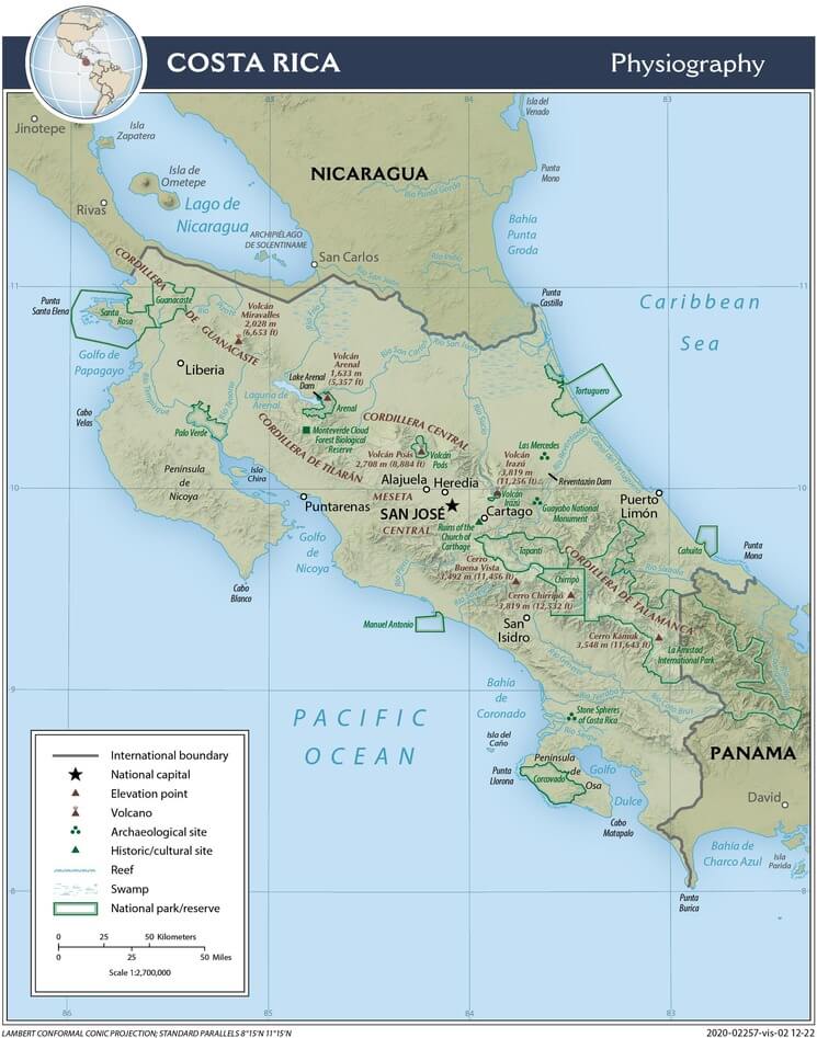
Physiographic map of Costa Rica.
Climate and Weather Patterns
Costa Rica's climatic diversity reflects the complex interaction of latitude, elevation, topography, and oceanic influences that create numerous microclimates within the country's borders. Located between 8° and 11° north latitude, Costa Rica lies entirely within the tropical zone. However, elevation differences of nearly 4,000 meters (13,123 feet) create climatic conditions that range from hot, humid lowlands to cool, temperate highlands, where frost occasionally occurs at the highest elevations.
The country experiences two primary seasons: the dry season (verano), from December to April, and the wet season (invierno), from May to November. However, this pattern varies significantly across different regions, with the Caribbean coast experiencing a more complex precipitation pattern that includes a brief dry period in February and March, as well as another in September and October. Annual precipitation ranges dramatically from less than 1,000 millimeters (39 inches) in parts of Guanacaste Province to over 7,000 millimeters (276 inches) in certain areas of the Caribbean slope and southern Pacific region.
Temperature patterns are primarily determined by elevation rather than seasonal variation. Lowland areas along both coasts typically experience average temperatures between 25°C and 27°C (77°F to 81°F) throughout the year, accompanied by high humidity levels that can make the conditions feel significantly warmer. The Central Valley's moderate elevation creates a subtropical highland climate with average temperatures ranging from 18°C to 24°C (64°F to 75°F), earning it the nickname "land of eternal spring" for its consistently pleasant conditions.
The mountainous regions experience cooler temperatures that decrease approximately 6°C per 1,000 meters of elevation gain (3.5°F per 1,000 feet). At the highest elevations, such as the páramo ecosystem atop Cerro Chirripó, temperatures can drop below freezing during clear nights, creating unique tropical alpine conditions found nowhere else in Central America.
Trade winds significantly influence Costa Rica's climate patterns, with the northeast trade winds bringing moisture-laden air from the Caribbean that creates the wet conditions characteristic of the Caribbean slope and windward mountain faces. The Pacific slope experiences more pronounced dry seasons due to the rain shadow effect produced by the mountain ranges, which force ascending air masses to release their moisture on the Caribbean-facing slopes.
Hydrography and Water Resources
Costa Rica's hydrographic network reflects the country's position as a continental divide, with rivers flowing toward both the Pacific and Caribbean drainage basins. The continental divide, formed primarily by the volcanic mountain chains and the Cordillera de Talamanca, creates two distinct watershed systems that drain approximately 60% of the country's area toward the Pacific Ocean and 40% toward the Caribbean Sea.
The Pacific watershed encompasses numerous river systems, with the Río Grande de Tárcoles representing the longest Pacific-flowing river at approximately 111 kilometers (69 miles) in length. This river system drains much of the Central Valley and surrounding highlands, carrying significant sediment loads that have created extensive coastal plains and influenced marine ecosystems along the Pacific coast. Other significant Pacific rivers include the Río Tempisque, which drains the northwestern Guanacaste region and supports extensive wetland systems, and the Río Grande de Térraba, the country's largest river by volume, which drains the southern Pacific region.
The Caribbean watershed features fewer but generally larger river systems, including the Río San Juan, which forms part of the border with Nicaragua and represents one of Central America's most significant waterways. The Río Reventazón, flowing from the Central Valley to the Caribbean, has been extensively developed for hydroelectric power generation, providing a substantial portion of Costa Rica's renewable energy supply. The Río Pacuare, renowned for its pristine conditions and whitewater rafting opportunities, drains the southern slopes of the Central Volcanic Range.
Costa Rica's extensive wetland systems play crucial roles in both freshwater and marine ecosystems. The Caño Negro Wildlife Refuge in the north encompasses seasonal wetlands that flood during the wet season, creating critical habitat for migratory birds and endemic species. Along the coasts, mangrove ecosystems in areas such as the Golfo Dulce and the Pacuare Delta create complex aquatic environments that serve as nurseries for marine species and act as buffer zones, protecting inland areas from storm surges and erosion.
Coastal Geography and Marine Environment
Costa Rica's 1,290 kilometers (802 miles) of coastline encompass two dramatically different marine environments that reflect the distinct characteristics of the Pacific and Caribbean ocean systems. The Pacific coast, spanning approximately 1,016 kilometers (631 miles), boasts a complex geography of beaches, rocky headlands, mangrove estuaries, and offshore islands, which create diverse marine habitats that support extraordinary biodiversity.
The Pacific marine environment includes several significant gulf systems, most notably the Golfo de Nicoya and the Golfo Dulce, which create protected waters ideal for marine life reproduction and human activities such as fishing and tourism. The Golfo de Nicoya, Costa Rica's largest gulf system, encompasses an area of approximately 1,500 square kilometers (579 square miles) and contains over 15 islands, including Chira Island, the country's second-largest island. These gulf systems create unique estuarine conditions where freshwater rivers meet saltwater, producing highly productive ecosystems that support commercial fisheries and extensive mangrove forests.
The Pacific coast also features several significant peninsulas, including the Nicoya Peninsula, which extends approximately 140 kilometers (87 miles) into the Pacific Ocean, and the Osa Peninsula, recognized as one of the most biologically diverse regions on Earth. The Osa Peninsula encompasses approximately 1,700 square kilometers (656 square miles) of pristine tropical rainforest, mangrove systems, and coastal ecosystems that support populations of endangered species, including jaguars, scarlet macaws, and Baird's tapirs.
Offshore Pacific waters encompass several important island systems, most notably the Cocos Islands, located approximately 550 kilometers (342 miles) southwest of the mainland. This UNESCO World Heritage site, covering 24 square kilometers (9 square miles), represents an oceanic island of volcanic origin that supports unique endemic species and serves as a critical waystation for pelagic species, including hammerhead sharks, whale sharks, and manta rays.
The Caribbean coast, though shorter at 274 kilometers (170 miles), presents equally important marine environments characterized by coral reefs, seagrass beds, and coastal lagoons. The Caribbean marine environment supports the southern extension of the Mesoamerican Reef system, with coral formations that, while smaller than those found further north, provide critical habitat for Caribbean marine species and support important tourism and fishing activities.
Geological Foundation
Costa Rica's geological complexity reflects its position at the convergence of the Cocos, Nazca, Caribbean, and North American tectonic plates, creating one of the most geologically active regions in the world. This tectonic setting has produced the volcanic activity, mountain building, and seismic activity that continue to shape the country's physical landscape and influence everything from soil formation to natural hazard risks.
The Central American Volcanic Arc, extending through Costa Rica from northwest to southeast, represents the surface expression of subduction zone volcanism where the Cocos Plate descends beneath the Caribbean Plate. This process has created approximately 200 volcanic formations within Costa Rica's borders, including 100 that show evidence of volcanic activity during the Quaternary period and several that remain active today.
Active volcanoes in Costa Rica include Arenal, which produced spectacular lava flows and eruptions from 1968 to 2010; Poás, with its sulfurous crater lake; Irazú, the country's highest volcano at 3,432 meters (11,260 feet); and Turrialba, which has experienced increased activity in recent years. These volcanic systems not only create dramatic landscapes but also contribute to soil fertility through the deposition of volcanic ash and the weathering of volcanic rocks into nutrient-rich andisols.
The Cordillera de Talamanca exhibits a distinct geological history, comprising primarily sedimentary and metamorphic rocks that were uplifted through tectonic processes rather than volcanic activity. These mountains contain some of the oldest rocks in Costa Rica, including formations dating back to the Paleozoic era. The Talamanca range also contains evidence of past glacial activity, with glacial valleys and cirques visible at the highest elevations, representing the southernmost evidence of Pleistocene glaciation in North America.
Coastal geology varies significantly between the Pacific and Caribbean shores. The Pacific coast features a complex mixture of volcanic rocks, uplifted marine terraces, and sedimentary formations that create the diverse topography characteristic of this region. The Caribbean coast consists primarily of recent sedimentary formations, including extensive alluvial deposits created by river systems draining the interior mountains.
Soils and Land Use
Costa Rica's soil geography reflects the complex interplay of geology, climate, topography, and biological processes that have operated over thousands of years to create diverse soil types, supporting a wide range of ecosystems and agricultural activities. Volcanic soils, known as andisols, cover approximately 14% of the country's territory and represent some of the most fertile soils in Central America.
Andisols, derived from volcanic ash and weathered volcanic rocks, are characterized by high organic matter content, excellent water retention capacity, and high fertility levels that support both intensive agriculture and diverse forest ecosystems. These soils are particularly well-developed in the Central Valley and on the slopes of active and dormant volcanoes, where they support coffee cultivation, vegetable production, and the ornamental plant industry, which form important components of Costa Rica's agricultural economy.
The mountainous regions of the Cordillera de Talamanca exhibit diverse soil characteristics, comprising inceptisols and entisols that are derived from the weathering of sedimentary and metamorphic rocks. These mountain soils, while generally less fertile than volcanic soils, provide adequate conditions for forest growth and support the unique páramo ecosystem at the highest elevations.
Coastal regions present distinct soil challenges and opportunities. Pacific coastal plains feature alluvial soils deposited by river systems, creating fertile conditions for agriculture in areas such as the Térraba Valley, where palm oil and rice production are significant economic activities. However, some coastal regions also contain problematic soils with high salt content or poor drainage, which limit their agricultural potential.
Land use patterns in Costa Rica reflect both geographical constraints and economic opportunities. Approximately 25% of the country's territory is designated as protected areas, including national parks, wildlife refuges, and forest reserves that preserve representative samples of different ecosystems. Agricultural activities occupy approximately 37% of the land area, with coffee production concentrated in the volcanic soils of the Central Valley and its surrounding highlands. In contrast, cattle ranching, palm oil cultivation, and banana production are more prominent in the lowland areas.
Biodiversity and Ecosystems
Costa Rica's position as a biological bridge between North and South America, combined with its remarkable diversity of elevations, climates, and habitats, has created conditions that support extraordinary biodiversity, placing the country among the world's most biodiverse nations per unit area. Despite covering only 0.03% of the Earth's land surface, Costa Rica supports approximately 5% of the world's known species, including over 500,000 documented species and an estimated total diversity that may exceed one million species.
The country's ecosystems encompass 12 different life zones according to the Holdridge classification system, ranging from tropical dry forests in Guanacaste Province to páramo alpine tundra atop the highest peaks of the Cordillera de Talamanca. Tropical rainforests cover approximately 47% of the country's territory and represent the most biodiverse terrestrial ecosystems, supporting complex communities of trees, epiphytes, mammals, birds, reptiles, amphibians, and countless invertebrate species.
Cloud forests, occurring at elevations between 1,000 and 3,000 meters (3,281 and 9,843 feet), represent unique ecosystems where persistent cloud cover creates conditions of high humidity and moderate temperatures that support endemic species and serve as critical watersheds for lowland river systems. The Monteverde Cloud Forest Reserve, one of Costa Rica's most renowned protected areas, exemplifies these ecosystems, supporting over 400 bird species, 100 mammal species, and thousands of plant and insect species.
Marine ecosystems along both the Pacific and Caribbean coasts support distinct biological communities adapted to different oceanic conditions. Pacific marine environments, influenced by upwelling currents and seasonal temperature variations, support populations of pelagic species, including dolphins, whales, sea turtles, and large fish species. The Caribbean marine environment, characterized by warmer and more stable conditions, supports coral reef ecosystems and endemic Caribbean species.
Costa Rica serves as a critical corridor for migratory species, with over 200 bird species using the country as a stopover point during annual migrations between North and South America. The country also supports significant populations of large mammals, including jaguars, pumas, tapirs, and several monkey species, though habitat fragmentation poses ongoing challenges for wildlife conservation.
Human Geography and Settlement Patterns
Human settlement patterns in Costa Rica reflect the fundamental influence of topography, climate, and resource availability on population distribution and economic development. The Central Valley, encompassing approximately 2% of the country's territory, supports nearly 60% of the national population, demonstrating the powerful attractive force of a favorable climate, fertile soils, and a central location for transportation and communication.
The Greater Metropolitan Area, centered on San José and including the cities of Cartago, Alajuela, and Heredia, represents the country's demographic and economic core with approximately 2.8 million inhabitants. This urban concentration reflects both the Central Valley's geographical advantages and the historical development of coffee cultivation, which required processing facilities, transportation infrastructure, and financial services that naturally concentrated in this central location.
Secondary urban centers have developed in response to specific geographical opportunities and constraints. Puntarenas, situated on the Pacific coast, evolved as the country's primary Pacific port, capitalizing on natural harbor conditions and serving as the terminus for coffee exports during the late 19th and early 20th centuries. Limón, on the Caribbean coast, emerged as the Atlantic port and continues to serve as the primary gateway for international trade with Europe and the eastern United States.
Rural settlement patterns reflect the country's diverse geographical environments and agricultural opportunities. The northwestern province of Guanacaste supports extensive cattle ranching operations that capitalize on the region's drier climate and natural grasslands. The Caribbean lowlands support banana cultivation that requires high rainfall and fertile alluvial soils characteristic of this region. Mountain slopes throughout the country support coffee cultivation, with farming communities established at elevations between 800 and 1,600 meters (2,625 and 5,249 feet) where climate conditions are optimal for high-quality coffee production.
Costa Rica's population of approximately 5.1 million people includes diverse ethnic groups that reflect both Indigenous heritage and centuries of immigration. The majority of the population is of mixed European and Indigenous ancestry, with significant communities of African descent, particularly along the Caribbean coast, and Indigenous groups including the Bribri, Cabécar, and other peoples who maintain traditional territories primarily in the southern mountains.
Natural Resources and Economic Geography
Costa Rica's natural resource base reflects its diverse geographical environment. The country has undergone significant evolution from its historical reliance on agricultural exports to a modern economy that emphasizes services, technology, and sustainable tourism. Costa Rica's renewable energy resources, derived primarily from hydroelectric, geothermal, wind, and solar sources, provide over 99% of the country's electricity generation, making it one of the world's leaders in renewable energy utilization.
Hydroelectric power generation in the country leverages its mountainous topography and abundant precipitation, with major installations including the Arenal, Cachí, and Reventazón projects, which harness river systems flowing from the volcanic ranges and the Cordillera de Talamanca. Geothermal energy development utilizes the volcanic activity associated with the Central American Volcanic Arc, with facilities near active volcanic areas such as Miravalles and Rincón de la Vieja.
Agricultural resources continue to play a crucial role in Costa Rica's economy, although their relative importance has declined as the economy has diversified. Coffee cultivation, concentrated in volcanic soils at moderate elevations, produces high-quality arabica coffee that commands premium prices in international markets. Banana production, primarily in the Caribbean and southern Pacific lowlands, capitalizes on year-round growing conditions and proximity to ports for efficient export.
Non-traditional agricultural products have gained importance in recent decades, including ornamental plants, pineapples, melons, and vegetables that capitalize on favorable climate conditions and modern transportation systems to access North American and European markets. The development of these agricultural sectors reflects Costa Rica's ability to capitalize on its geographical advantages while adapting to shifting global market conditions.
Tourism has emerged as Costa Rica's most important economic sector, generating approximately $4 billion annually and employing over 200,000 people directly and indirectly. The tourism industry relies heavily on the country's geographical assets, including national parks, beaches, volcanoes, cloud forests, and wildlife viewing opportunities, which attract over 3 million international visitors annually.
Volcanic Activity and Natural Hazards
Costa Rica's position within the Central American Volcanic Arc presents both spectacular natural attractions and significant natural hazard risks that influence land-use planning, infrastructure development, and emergency preparedness throughout the country. The country's 200 volcanic formations include approximately a dozen that remain active or potentially active, requiring ongoing monitoring and risk assessment by the National Seismological Network and other scientific institutions.
Arenal Volcano, perhaps Costa Rica's most famous volcanic peak, produced continuous activity from 1968 to 2010, including spectacular lava flows, explosive eruptions, and pyroclastic flows that created both tourist attractions and evacuation zones. The volcano's current dormant phase demonstrates the unpredictable nature of volcanic systems and the importance of long-term monitoring and preparedness planning.
Poás Volcano, featuring one of the world's largest active crater lakes, regularly produces phreatic eruptions and acidic rain that affect surrounding agricultural areas, requiring the periodic closure of the national park due to hazardous gas emissions. Irazú Volcano, visible from San José on clear days, last erupted from 1963 to 1965, covering much of the Central Valley with volcanic ash that, while temporarily disruptive, ultimately contributed to soil fertility.
Turrialba Volcano has experienced increased activity since 2010, producing ash emissions that have affected air travel, agricultural production, and public health in the Central Valley. This recent activity demonstrates the ongoing geological processes that continue to shape Costa Rica's landscape and influence human activities.
Seismic activity associated with tectonic processes poses additional natural hazard risks throughout Costa Rica. The country experiences frequent earthquakes, including several significant events that have caused substantial damage to infrastructure and human settlements. The 1991 Limón earthquake, measuring 7.7 on the Richter scale, caused extensive damage along the Caribbean coast and altered coastal topography through uplift and subsidence.
Environmental Challenges and Conservation
Costa Rica faces complex environmental challenges that reflect both its remarkable natural heritage and the pressures of modern economic development. Deforestation, which reduced forest cover from approximately 75% in the 1940s to less than 25% by the 1980s, has been partially reversed through reforestation efforts, payments for ecosystem services, and the expansion of protected areas. The current forest cover has recovered to approximately 54% of the national territory, although habitat fragmentation remains a significant challenge for wildlife conservation.
Climate change impacts pose increasing threats to Costa Rica's diverse ecosystems and human communities. Rising temperatures threaten cloud forest ecosystems, which depend on specific climatic conditions, while changing precipitation patterns impact both natural systems and agricultural production. Sea level rise poses a significant threat to coastal communities and ecosystems, particularly along the Caribbean coast, where much of the infrastructure is situated at or near sea level.
Marine environmental challenges include coral bleaching, pollution from agricultural runoff and urban development, and overfishing pressures that threaten the health of both Pacific and Caribbean marine ecosystems. The country's marine protected areas, including Cocos Island National Park and several coastal reserves, aim to preserve critical marine habitats while supporting sustainable fishing and tourism activities.
Water resource management presents ongoing challenges as population growth, urbanization, and agricultural intensification increase demands on freshwater supplies. Pollution of rivers and groundwater from agricultural chemicals, urban runoff, and inadequate sewage treatment affects both human communities and aquatic ecosystems nationwide.
Costa Rica's response to these environmental challenges has made the country a global leader in conservation and sustainable development. The national system of protected areas encompasses over 25% of the country's territory and includes representatives of all major ecosystems. The Payment for Ecosystem Services program provides economic incentives for forest conservation, reforestation, and sustainable land management practices that benefit both environmental protection and rural economic development.
Conclusion
The geography of Costa Rica represents a remarkable concentration of natural diversity, geological complexity, and ecological richness that has profoundly influenced the country's development and continues to shape its prospects. From the volcanic peaks of the Central American Arc to the pristine beaches of both Pacific and Caribbean coasts, from tropical dry forests to cloud forests and páramo ecosystems, Costa Rica demonstrates how geographical diversity can create extraordinary opportunities for biological conservation, sustainable development, and scientific research.
The country's strategic location, serving as a bridge between continents and oceans, has facilitated biological exchange, resulting in one of the world's most biodiverse regions. Its topographical complexity has created diverse climates and habitats that support this remarkable natural heritage. The volcanic soils, abundant water resources, and favorable climate conditions have provided the foundation for agricultural development and renewable energy production, supporting economic prosperity while maintaining environmental quality.
Costa Rica's human geography reflects the fundamental influence of physical geography on settlement patterns, with the majority of the population concentrated in the Central Valley. This region's moderate elevation creates favorable climate conditions, and its fertile volcanic soils support intensive agriculture. The development of tourism based on the country's natural attractions has created new economic opportunities while providing incentives for environmental conservation.
The challenges facing Costa Rica's geography in the 21st century include the impacts of climate change, habitat fragmentation, water resource management, and the need to balance economic development with environmental protection. The country's success in addressing these challenges will depend on its continued commitment to sustainable development principles, scientific research, and international cooperation in addressing global environmental issues.
Costa Rica's geographical legacy extends far beyond its national boundaries, serving as a model for small nations seeking to leverage natural resources for sustainable development while preserving ecological integrity. Through innovative approaches to conservation, renewable energy development, and ecosystem services, Costa Rica demonstrates how geographical advantages can be leveraged to achieve long-term prosperity that benefits both human communities and natural ecosystems.
The future of Costa Rica's geography will be shaped by the country's ability to adapt to changing global conditions while maintaining the ecological integrity and natural beauty that define this remarkable nation. Through continued investment in conservation, research, and sustainable development, Costa Rica can continue to serve as a global leader in demonstrating how human societies can thrive within the constraints and opportunities provided by their geographical environment.