The Geography of Belize: From Blue Hole to Maya Peaks
Nestled along the Caribbean coast of Central America, Belize is a geographic gem linking North and South America. It features the second-largest barrier reef, ancient Maya mountains, tropical rainforests, and wetlands, showcasing a diverse landscape despite its small size.

 via Wikimedia Commons")


, CC BY 2.0, https://www.flickr.com/photos/88029159@N00/5117809268")
 via Wikimedia Commons")
Between Two Seas: The Physical Geography and Environmental Heritage of Belize
Nestled along the Caribbean coast of Central America, Belize stands as a unique geographical jewel that bridges North and South America. This small nation, covering approximately 22,966 square kilometers (8,867 square miles), presents an extraordinary diversity of landscapes, ecosystems, and geological formations within its compact borders. From the world's second-largest barrier reef system to ancient Maya mountains, from dense tropical rainforests to expansive wetlands, Belize offers a remarkable tapestry of geographical features that belie its modest size. The country's strategic location, bordered by Mexico to the north, Guatemala to the west and south, and the Caribbean Sea to the east, has shaped both its natural environment and human settlement patterns throughout history.
Physical Geography and Topography
Belize's topography can be divided into four distinct physiographic regions, each contributing to the nation's remarkable geographical diversity. The coastal plain, extending inland for approximately 60 kilometers (37 miles), dominates the northern and central portions of the country. This low-lying region, rarely exceeding 200 meters (656 feet) above sea level, is characterized by limestone bedrock, numerous rivers, and extensive wetlands that create ideal conditions for both wildlife habitats and human settlement.
The Maya Mountains, rising dramatically in the south-central region, represent Belize's most significant topographical feature. These ancient formations, part of the larger Central American mountain system, reach their highest point at Doyle's Delight, standing at 1,124 meters (3,688 feet) above sea level. The mountains consist primarily of granite, slate, and sandstone, contrasting sharply with the limestone formations that characterize much of the rest of the country. The steep slopes and rugged terrain of the Maya Mountains create numerous waterfalls, including the spectacular Thousand Foot Falls, which plunges approximately 487 meters (1,600 feet) into the valley below.
The northern lowlands present a relatively flat landscape dominated by limestone karst topography, featuring numerous cenotes, underground rivers, and cave systems. This region's elevation rarely exceeds 76 meters (250 feet), creating ideal conditions for agriculture and the extensive pine savanna ecosystems that characterize much of northern Belize. The southern coastal plain stretches along the Caribbean shore, encompassing mangrove swamps, lagoons, and river deltas that provide critical habitat for both marine and terrestrial species.
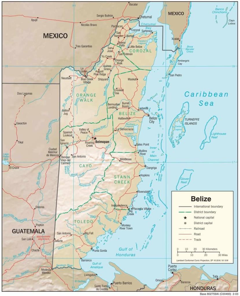
Physiographic map of Belize.
Climate and Weather Patterns
Belize experiences a tropical climate with distinct wet and dry seasons, moderated by its coastal location and the prevailing northeast trade winds. The country's climate is characterized by relatively stable temperatures throughout the year, with average temperatures ranging from 24°C to 27°C (75°F to 81°F) in coastal areas and slightly cooler temperatures in the mountainous interior, where elevations can reduce temperatures by approximately 6°C per 1,000 meters of elevation (3.5°F per 1,000 feet).
The dry season, which extends from December to May, is characterized by lower humidity, minimal rainfall, and consistent trade winds that provide natural cooling. During this period, monthly rainfall typically ranges from 25 to 76 millimeters (1 to 3 inches), with February and March being the driest months. The wet season, which spans from June to November, brings significantly increased precipitation, with annual rainfall varying dramatically across the country. Coastal areas typically receive between 1,270 and 1,905 millimeters (50 to 75 inches) of rainfall annually, while the mountainous interior can experience up to 4,064 millimeters (160 inches) of precipitation per year.
Hurricane season, coinciding with the wet season, poses a significant climatic challenge for Belize. The country lies directly in the path of Atlantic hurricanes, with major storms historically causing substantial damage to infrastructure, ecosystems, and human settlements. Notable hurricanes, including Hurricane Hattie in 1961 and Hurricane Mitch in 1998, have fundamentally altered both the physical landscape and human settlement patterns throughout the country.
Hydrography and Water Resources
Belize's hydrographic network consists of numerous rivers, streams, and coastal water bodies that drain the country's diverse landscapes. The Belize River, the nation's longest and most significant waterway, flows approximately 290 kilometers (180 miles) from the Maya Mountains to the Caribbean Sea. This river system has historically served as a crucial transportation corridor and continues to support both ecological diversity and human communities along its banks.
The Motagua River system, although primarily located in Guatemala, has a significant influence on the hydrology and sediment deposition patterns of southeastern Belize. Other major rivers include the Rio Hondo, forming part of the northern border with Mexico, and the Sarstoon River, which defines portions of the southern border with Guatemala. These river systems create extensive wetlands, particularly in the northern and central regions, which support diverse ecosystems and serve as natural flood control mechanisms.
Coastal hydrology plays a crucial role in Belize's geography, with numerous lagoons, estuaries, and mangrove systems creating a complex aquatic environment. The Placencia Lagoon, Corozal Bay, and Chetumal Bay represent significant coastal water bodies that support both marine ecosystems and human activities such as fishing and tourism. These coastal waters are intimately connected to the Belize Barrier Reef system, forming a complex marine environment that extends from the shoreline to the deep waters of the Caribbean Sea.
Coastal Geography and Marine Environment
Belize's 386-kilometer (240-mile) Caribbean coastline presents a complex geography of beaches, mangrove forests, cayes (small islands), and coral reef systems. The Belize Barrier Reef, spanning approximately 300 kilometers (190 miles) along the coast, is the second-largest coral reef system in the world and forms part of the larger Mesoamerican Reef system, which extends from Mexico to Honduras.
The reef system encompasses four distinct types of coral formations: fringing reefs that grow close to the mainland coast, barrier reefs that parallel the shoreline at distances of 15 to 25 kilometers (9 to 16 miles) offshore, patch reefs scattered throughout the lagoon between the mainland and barrier reef, and three coral atolls that represent unique circular reef formations in deeper waters. These atolls – Turneffe Atoll, Lighthouse Reef Atoll, and Glover's Reef Atoll – create distinctive circular or oval-shaped coral formations surrounding central lagoons.
The famous Blue Hole, situated within the Lighthouse Reef Atoll, is one of Belize's most iconic geographical features. This circular submarine sinkhole, measuring approximately 300 meters (984 feet) in diameter and 125 meters (410 feet) deep, was formed during past ice ages when sea levels were significantly lower. The Blue Hole's distinctive deep blue color, contrasting with the lighter blue-green waters of the surrounding reef, creates a striking visual landmark visible even from space.
The coastal zone includes over 200 cayes, ranging from small mangrove islets to larger islands such as Ambergris Caye and Caye Caulker, which support permanent human settlements. These cayes, formed primarily through coral growth and sediment accumulation, create natural barriers that protect the mainland coast from wave action while providing critical habitat for marine and terrestrial species.
Geological Foundation
Belize's geological foundation reflects a complex history of tectonic activity, volcanic processes, and sedimentary deposition spanning millions of years. The country sits at the intersection of the North American Plate and the Caribbean Plate, creating a geologically diverse landscape that influences everything from mineral resources to natural hazard risks.
The northern and central regions of Belize are characterized by limestone formations dating back to the Cretaceous and Tertiary periods, which have created the distinctive karst topography that defines much of the country's landscape. These limestone formations, some reaching thicknesses of over 1,000 meters (3,280 feet), contain numerous caves, underground rivers, and cenotes that create unique hydrological systems. The Chiquibul Cave System, extending over 100 kilometers (62 miles) of mapped passages, represents one of the largest cave systems in Central America.
The Maya Mountains present a dramatically different geological composition, consisting primarily of Paleozoic metamorphic rocks, including granite, slate, and quartzite formations. These ancient rocks, some dating back over 300 million years, represent the oldest geological formations in Belize and create the rugged topography that characterizes the southern interior. The contact zone between the limestone lowlands and the metamorphic mountains creates unique geological conditions that influence soil formation, hydrology, and mineral distribution.
Volcanic activity, although currently inactive in Belize, has had a significant impact on the country's geological history. Evidence of past volcanic activity can be found in various rock formations throughout the Maya Mountains, contributing to the diverse mineral composition, which includes small deposits of gold, lead, and zinc.
Soils and Land Use
Belize's soil geography reflects the complex interplay of geology, climate, topography, and vegetation that has evolved over thousands of years. The limestone-dominated regions typically support shallow, alkaline soils known as rendzinas, which are generally fertile but require careful management to prevent erosion and maintain productivity. These soils, ranging in depth from a few centimeters to several meters, support both natural forest ecosystems and agricultural activities, particularly in areas where organic matter accumulation has created deeper soil profiles.
The Maya Mountains region features different soil characteristics, with deeper, more acidic soils derived from the weathering of metamorphic rocks. These mountain soils, while often less naturally fertile than their limestone counterparts, provide better drainage and support different vegetation communities adapted to the higher elevation and increased precipitation patterns.
Coastal areas present unique soil conditions, with sandy soils near beaches transitioning to organic-rich soils in mangrove areas and wetlands. These coastal soils play crucial roles in supporting mangrove ecosystems and filtering nutrients and sediments before they reach marine environments.
Agricultural land use in Belize accounts for approximately 6.9% of the total land area, with crops such as sugar cane, citrus fruits, bananas, and corn representing the primary agricultural activities. The distribution of agricultural land reflects both soil quality and accessibility, with the most productive agricultural regions located in the northern and central coastal plains, where limestone-derived soils and relatively flat topography create favorable conditions for mechanized farming.
Biodiversity and Ecosystems
Belize's compact size belies its extraordinary ecological diversity, with the country supporting an estimated 150 mammal species, over 500 bird species, 150 reptile and amphibian species, and countless invertebrate species. This remarkable biodiversity reflects the country's position at the biological crossroads between North and South America, combined with its diverse range of habitats from coastal marine environments to mountain forests.
The country's terrestrial ecosystems comprise tropical broadleaf forests, which cover approximately 60% of the land area, pine savannas in the northern and central regions, coastal mangrove forests, and specialized mountain ecosystems in the Maya Mountains. Each ecosystem supports distinct communities of plants and animals adapted to specific environmental conditions.
Marine ecosystems associated with the barrier reef system support an equally impressive diversity of species, including over 100 coral species, 500 fish species, and numerous marine mammals, sea turtles, and invertebrates. The health and productivity of the reef system depend on the complex relationships between coral polyps, algae, fish communities, and the broader Caribbean marine environment.
Human Geography and Settlement Patterns
Human settlement in Belize reflects the complex interplay of geography, history, and economic opportunities. The country's population of approximately 400,000 people is distributed unevenly across the landscape, with the highest population densities concentrated in coastal areas and along major river valleys, where transportation, water resources, and economic opportunities converge.
Belize City, the country's largest urban center with approximately 70,000 residents, developed at the mouth of the Belize River, taking advantage of the natural harbor and river transportation system. However, the city's low elevation and coastal location make it vulnerable to hurricanes and flooding, leading to the establishment of Belmopan as the inland capital city in 1970.
The geographic distribution of Belize's ethnically diverse population reflects both historical settlement patterns and ongoing economic opportunities. Mestizo populations, comprising approximately 53% of the total population, are primarily concentrated in the northern and western regions of the country. Creole populations, accounting for approximately 26% of the population, are mainly located along the coast and in Belize City. Maya populations, representing approximately 11% of the total, are primarily located in the southern and western regions, particularly in areas near the Guatemalan border.
Natural Resources and Economic Geography
Belize's natural resource base reflects its diverse geographical environments, with forestry, agriculture, fishing, and tourism representing the primary resource-based economic activities. The country's extensive forest cover, which includes valuable hardwood species such as mahogany, cedar, and rosewood, has historically formed the foundation of the colonial economy and continues to provide important economic opportunities through sustainable forestry practices.
Marine resources associated with the barrier reef system support important fishing industries, particularly for lobster, conch, and various reef fish species. However, the sustainable management of these resources requires careful attention to ecological limits and the health of marine ecosystems.
Tourism, increasingly important to Belize's economy, depends directly on the country's unique geographical features, including the barrier reef, Blue Hole, rainforests, Maya ruins, and diverse wildlife. This geographic advantage positions Belize as a premier destination for eco-tourism, diving, snorkeling, and cultural tourism activities.
Agricultural production in the northern and central regions benefits from fertile limestone soils and favorable climate conditions, supporting the cultivation of sugarcane, citrus, and bananas for both domestic consumption and export markets. The geographic concentration of agricultural activities in specific regions reflects both environmental suitability and patterns of infrastructure development.
Environmental Challenges and Conservation
Belize faces significant environmental challenges that reflect both its geographical characteristics and the pressures of human development. Coastal erosion, exacerbated by rising sea levels and intensified storms, poses a significant threat to both natural ecosystems and human communities. The low-lying coastal plains, where a substantial portion of the population resides, are particularly vulnerable to these changes.
Deforestation pressures, driven by agricultural expansion and development activities, pose threats to the country's forest ecosystems and the biodiversity they support. The Maya Mountains, although partially protected through national parks and reserves, continue to face ongoing pressure from logging, mining exploration, and agricultural encroachment.
Marine environmental challenges include coral bleaching, pollution from land-based sources, and overfishing pressures that threaten the health and productivity of reef ecosystems. Climate change impacts, including rising ocean temperatures and increased acidification, pose long-term threats to the barrier reef system that forms the foundation of Belize's marine environment.
Conservation efforts in Belize encompass approximately 25% of the country's land area through a system of national parks, wildlife sanctuaries, and protected reserves. These protected areas, distributed across different ecosystems and elevation zones, aim to preserve representative samples of Belize's biological diversity while providing opportunities for sustainable tourism and research activities.
Conclusion
The geography of Belize presents a remarkable concentration of diverse landscapes, ecosystems, and natural features within a relatively small national territory. From the world-renowned barrier reef system to the ancient Maya Mountains, from extensive tropical forests to complex coastal wetlands, Belize demonstrates how geographical diversity can create extraordinary ecological and economic opportunities.
The country's strategic location at the crossroads of North and South America, combined with its diverse topography and favorable climate, has created conditions that support exceptional biodiversity and unique natural features such as the Blue Hole and extensive cave systems. These geographical advantages have shaped human settlement patterns, economic activities, and cultural development throughout the country's history.
However, Belize's geographical characteristics also present significant challenges, particularly in the context of climate change, sea level rise, and increasing development pressures. The low-lying coastal areas, where most of the population resides, remain vulnerable to hurricanes and flooding. Meanwhile, the country's small size means that environmental impacts can quickly affect large portions of the national territory.
The future of Belize depends largely on the country's ability to balance economic development needs with the conservation of the geographical features and ecosystems that make it unique. Sustainable management of marine resources, forest conservation, and climate change adaptation will be essential for maintaining the geographical integrity and natural beauty that define this remarkable Central American nation. Through careful stewardship of its geographical heritage, Belize can continue to serve as a model for small nations seeking to balance development with conservation in an increasingly connected and changing world.