Chile's Diverse Aquatic Landscape: From Desert Springs to Glacial Lakes:
Chile's geography, stretching along South America's western coast, creates a highly diverse hydrological system. It includes high-altitude salt flats where flamingos feed, temperate rainforest rivers with ancient forests, and pristine glacial lakes reflecting snow-capped volcanoes.


, https://www.flickr.com/photos/cg_fotografia/31578253402")


Chile's Liquid Landscape: A Journey Through Desert Oases and Glacial Lakes
Chile's extraordinary geography, stretching over 4,300 km (2,670 mi) along South America's western coast while averaging only 180 km (112 mi) in width, creates one of the world's most diverse hydrological systems. From the arid Atacama Desert in the north to the glacier-fed fjords of Patagonia in the south, the nation's water bodies tell a remarkable story of geological forces, climatic extremes, and ecological adaptation that spans multiple latitudes and elevations. This ribbon-like country encompasses environments ranging from high-altitude salt flats, where flamingos feed in mineral-rich lagoons, to temperate rainforest rivers supporting ancient forests, to pristine glacial lakes that reflect snow-capped volcanic peaks. The dramatic topographical contrasts between the towering Andes Mountains and the Pacific Ocean create microclimates and watersheds that sustain both unique endemic species and diverse human communities, making Chile's aquatic landscape a living laboratory of hydrological diversity shaped by millions of years of tectonic activity and climate variation.
The Andean Backbone and Its Hydrological Influence
The Andes Mountains form Chile's eastern spine, serving as the primary watershed that divides the country's drainage systems. These towering peaks, reaching elevations exceeding 6,000 m (19,685 ft), capture moisture from both Pacific and Atlantic weather systems, creating a complex network of rivers, lakes, and seasonal water bodies that sustain life across dramatically different climatic zones.
The Andean snowpack and glacial systems function as natural reservoirs, storing water during winter months and releasing it gradually through spring and summer melting cycles. The extensive ice fields of Patagonia, including the Northern and Southern Patagonian Ice Fields, represent the largest temperate ice masses in the Southern Hemisphere outside Antarctica, covering approximately 16,800 km² (6,490 sq mi) combined.
Northern Desert Waters: Oases in Extreme Aridity
Despite receiving less than 1 mm (0.04 in) of annual precipitation in some areas, Chile's northern Atacama Desert region contains several significant water bodies that support unique ecosystems and human settlements. The Salar de Atacama, covering 3,000 km² (1,158 sq mi), stands as South America's largest salt flat and contains substantial brine deposits rich in lithium and other minerals.
High-altitude lakes dot the Andean plateau, known as the Altiplano, where elevation exceeds 3,500 m (11,483 ft). Lake Chungará, situated at 4,517 m (14,820 ft) above sea level, ranks among the world's highest navigable lakes. These alpine waters support flamingo populations and other specialized fauna adapted to extreme altitude and temperature variations.
The region's rivers, including the Loa River—Chile's longest at 440 km (273 mi)—originate from Andean sources and often disappear into desert sands or terminate in closed basins. These ephemeral waterways create ribbon oases that have supported human habitation for millennia.
Central Valley: Agricultural Heartland Waters
Chile's central region, encompassing the fertile Central Valley between the Andes and Coastal Range, contains the country's most economically important water resources. The Mediterranean climate supports extensive agriculture, wine production, and urban centers housing over 60% of Chile's population.
Major rivers traversing the Central Valley include the Maipo, Maule, and Biobío systems, each originating from Andean watersheds and flowing westward to the Pacific Ocean. The Maipo River basin supplies water to Santiago, Chile's capital and largest metropolitan area with over 7 million inhabitants, while also irrigating extensive agricultural lands in the surrounding valleys.
Artificial reservoirs play crucial roles in water management throughout the central region. Embalse Rapel, created by damming the Rapel River, covers 40 km² (15 sq mi) and serves multiple purposes, including hydroelectric generation, irrigation supply, and recreational activities. Similarly, Embalse Colbún, located on the Maule River system, demonstrates how engineering solutions address seasonal water availability challenges.
Lake District: Glacial Legacy Landscapes
The Lake District, extending from approximately 37° to 42° South latitude, showcases Chile's most scenic concentration of freshwater lakes formed primarily through glacial action during successive ice ages. This region contains over 30 significant lakes, creating a landscape that supports tourism, aquaculture, and distinctive ecosystems.
Lake Llanquihue, covering 860 km² (332 sq mi), stands as Chile's second-largest lake and exemplifies the region's glacial heritage. The lake's 195 m (640 ft) maximum depth and crystal-clear waters reflect the snow-capped volcanoes Osorno and Calbuco, creating iconic vistas that define Chilean natural beauty.
Lake Villarrica, despite its smaller size at 176 km² (68 sq mi), holds particular ecological and cultural significance. The active Villarrica Volcano influences the lake's thermal characteristics, while Indigenous Mapuche communities have maintained traditional relationships with these waters for centuries.
The region's numerous rivers, including the Valdivia, Imperial, and Toltén systems, connect lake systems to coastal estuaries, creating complex freshwater-marine interfaces that support diverse fish populations and migratory bird species.
Patagonian Wilderness: Fjords and Pristine Waters
Southern Chile's Patagonian region is home to some of the planet's most pristine and remote water bodies, characterized by deep fjords, glacial lakes, and rivers that flow through virtually untouched wilderness. The complex geography of islands, peninsulas, and waterways creates a maze of marine and freshwater environments supporting unique cold-water ecosystems.
General Carrera Lake, shared with Argentina, where it becomes Lake Buenos Aires, covers 1,850 km² (714 sq mi) on the Chilean side, making it the country's largest lake. The lake's turquoise waters, colored by glacial flour, reach depths exceeding 590 m (1,936 ft) and contain water so pure it approaches distilled water quality in some areas.
The Baker River, Chile's most voluminous river with an average flow of 1,100 m³/s (38,850 ft³/s), drains vast areas of Patagonian ice fields and lakes before reaching the Pacific through a complex network of fjords. The river's distinctive blue-green color is attributed to glacial minerals and has made it a symbol of Patagonian wilderness preservation efforts.
Extensive fjord systems along the Pacific coast create sheltered waterways that penetrate deep into the continental landmass. These marine environments support cold-water fisheries, marine mammal populations, and serve as critical habitat for numerous seabird species adapted to harsh southern ocean conditions.
Rivers: Arteries of the Nation
Chilean rivers demonstrate remarkable diversity in character, volume, and ecological function across the country's latitudinal range. Unlike many continental river systems, Chilean rivers are relatively short due to the narrow continental width, creating steep gradients and rapid flows that generate significant hydroelectric potential.
The Biobío River system, historically significant for both Indigenous cultures and colonial settlement, flows 380 km (236 mi) from Andean sources to the Pacific Ocean. Multiple dams along its course generate substantial hydroelectric power while creating controversy regarding environmental impacts and Indigenous land rights.
Northern rivers face extreme challenges from mining activities and water scarcity, while southern rivers benefit from abundant precipitation and minimal human impact. The Imperial River in the Lake District maintains some of Chile's cleanest waters, supporting native fish species and serving as a model for river conservation efforts.
Coastal and Marine Waters
Chile's 6,435 km (4,000 mi) coastline creates extensive marine environments influenced by the cold Humboldt Current, which brings nutrient-rich waters supporting some of the world's most productive marine ecosystems. Coastal lagoons, estuaries, and wetlands provide critical habitat for resident and migratory species while offering protection from Pacific storms.
The Humboldt Current system influences not only marine productivity but also terrestrial climate patterns, contributing to the extreme aridity of northern regions while moderating temperatures along the entire coast. Upwelling zones create local climate variations and support concentrated populations of marine life, which sustain Chile's vital fishing industry.
Hydropolitics and Water Management Challenges
Chile's water resources are facing increasing pressure from population growth, agricultural expansion, mining activities, and the impacts of climate change. The country's unique geography presents both opportunities and challenges for water management, with abundant resources in sparsely populated southern regions, while water-stressed central and northern areas contain the majority of economic activity and population centers.
Legal frameworks governing water rights, established during periods of military government, continue to influence resource allocation and environmental protection efforts. Competing demands between urban supply, agricultural irrigation, industrial use, and ecosystem preservation create complex management scenarios requiring sophisticated policy solutions.
Climate change projections indicate shifting precipitation patterns, with decreased snowpack in central regions and altered seasonal flow patterns affecting traditional water availability cycles. These changes necessitate adaptive management strategies and infrastructure investments to ensure the sustainable use of water resources.
Ecological Significance and Biodiversity
Chilean water bodies support extraordinary biodiversity adapted to diverse climatic and geographic conditions. Endemic fish species, including several threatened taxa, inhabit isolated lake systems and river basins throughout the country. The Chilean Patagonian region exhibits particularly high levels of endemism, mainly due to its geographic isolation and minimal human impact.
Wetland ecosystems associated with rivers, lakes, and coastal areas provide critical habitat for numerous bird species, including several endangered taxa. The Ramsar Convention recognizes multiple Chilean wetlands as internationally important, highlighting their global conservation significance.
Aquatic ecosystems face numerous threats, including the introduction of invasive species, habitat modification, pollution, and climate change. Native fish populations have experienced significant declines due to competition from introduced salmonids, while industrial and agricultural activities impact water quality in developed regions.
Economic Importance
Water resources underpin Chile's economy through multiple sectors, including agriculture, mining, energy generation, and tourism. The country's wine industry, internationally recognized for its quality and innovation, relies entirely on controlled irrigation systems that draw water from Andean watersheds and reservoir storage.
Hydroelectric generation supplies approximately 28% of Chile's electricity, with major facilities concentrated in central and southern regions where topography and precipitation create favorable conditions. The mining sector, particularly copper production, requires enormous water quantities, creating competition with other users in arid northern regions.
Salmon aquaculture in southern fjords and lakes represents a major export industry, though environmental concerns regarding water quality impacts and ecosystem effects continue to generate debate and regulatory responses.
Summary
Chile's water bodies represent a microcosm of global hydrological diversity, encompassing everything from high-altitude salt flats to temperate rainforest rivers, from glacial lakes to marine fjords. The country's unique geography creates extraordinary contrasts within relatively short distances, supporting diverse ecosystems and human activities while presenting complex management challenges.
The nation's water resources reflect both natural abundance and scarcity, depending on location and seasonal variation. Northern desert regions demonstrate how life adapts to extreme water limitation, while southern Patagonian areas contain some of Earth's purest and most abundant freshwater reserves.
Understanding and protecting these diverse aquatic systems requires integrated approaches that balance human needs with ecosystem preservation, recognize Indigenous rights and traditional knowledge, and adapt to changing climatic conditions. Chile's water bodies continue to shape the nation's identity, economy, and environmental future while serving as valuable examples of how geography, climate, and human activity interact to create complex hydrological systems.
The preservation of these water resources for future generations represents one of Chile's most critical environmental and economic challenges, requiring sophisticated policy frameworks, international cooperation, and sustained commitment to sustainable development principles.
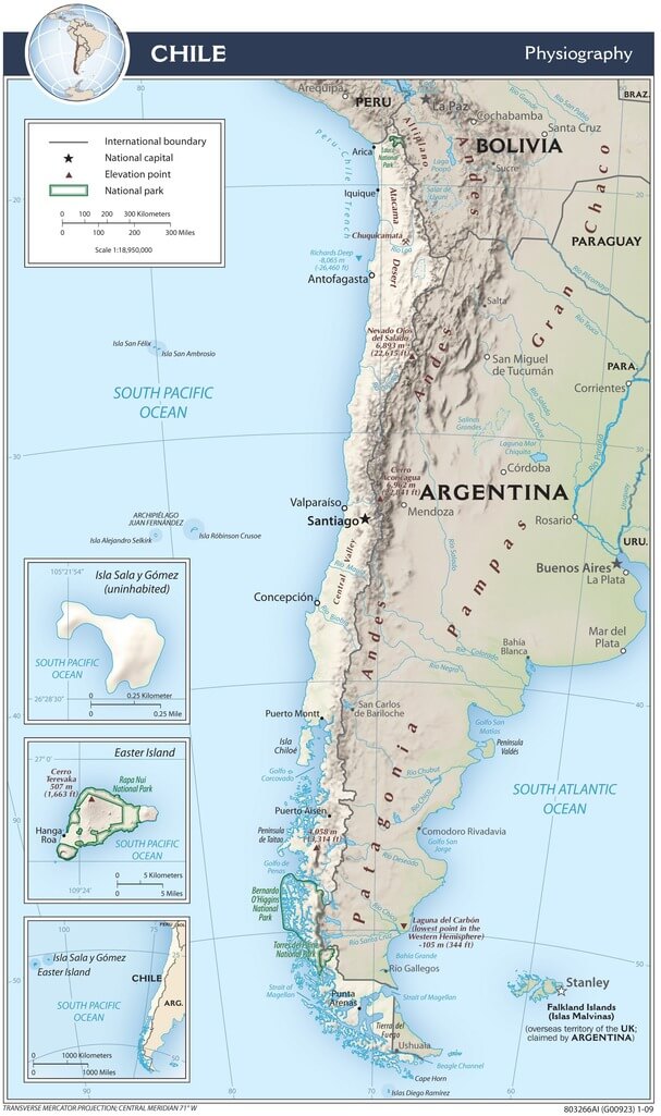
Chile physiographic map.
Comprehensive List of Significant Chilean Water Bodies
Lakes
General Carrera Lake (Lago General Carrera)
- Size: 1,850 km² (714 sq mi) - Chilean portion
- Location: Aysén Region, shared with Argentina
- Maximum depth: 590 m (1,936 ft)
Lake Llanquihue (Lago Llanquihue)
- Size: 860 km² (332 sq mi)
- Location: Los Lagos Region
- Maximum depth: 195 m (640 ft)
Lake Ranco (Lago Ranco)
- Size: 410 km² (158 sq mi)
- Location: Los Ríos Region
- Maximum depth: 199 m (653 ft)
Lake Puyehue (Lago Puyehue)
- Size: 156 km² (60 sq mi)
- Location: Los Lagos Region
- Maximum depth: 135 m (443 ft)
Lake Villarrica (Lago Villarrica)
- Size: 176 km² (68 sq mi)
- Location: Araucanía Region
- Maximum depth: 167 m (548 ft)
Lake Calafquén (Lago Calafquén)
- Size: 120 km² (46 sq mi)
- Location: Los Ríos Region
- Maximum depth: 220 m (722 ft)
Lake Chungará (Lago Chungará)
- Size: 21.5 km² (8.3 sq mi)
- Location: Arica and Parinacota Region
- Elevation: 4,517 m (14,820 ft)
Rivers
Loa River (Río Loa)
- Length: 440 km (273 mi)
- Location: Antofagasta Region
- Flow: Variable, desert river
Baker River (Río Baker)
- Length: 170 km (106 mi)
- Location: Aysén Region
- Average flow: 1,100 m³/s (38,850 ft³/s)
Biobío River (Río Biobío)
- Length: 380 km (236 mi)
- Location: Biobío Region
- Average flow: 900 m³/s (31,783 ft³/s)
Maule River (Río Maule)
- Length: 240 km (149 mi)
- Location: Maule Region
- Average flow: 468 m³/s (16,527 ft³/s)
Maipo River (Río Maipo)
- Length: 250 km (155 mi)
- Location: Metropolitan and Valparaíso Regions
- Average flow: 92 m³/s (3,249 ft³/s)
Imperial River (Río Imperial)
- Length: 52 km (32 mi)
- Location: Araucanía Region
- Average flow: 185 m³/s (6,533 ft³/s)
Salt Flats and High-Altitude Water Bodies
Salar de Atacama
- Size: 3,000 km² (1,158 sq mi)
- Location: Antofagasta Region
- Elevation: 2,300 m (7,546 ft)
Salar de Uyuni (Chilean portion)
- Size: ~150 km² (58 sq mi) - Chilean section
- Location: Antofagasta Region, border with Bolivia
- Elevation: 3,656 m (11,995 ft)
Reservoirs
Embalse Rapel
- Size: 40 km² (15 sq mi)
- Location: O'Higgins Region
- Capacity: 695 million m³ (563,740 acre-ft)
Embalse Colbún
- Size: 56 km² (22 sq mi)
- Location: Maule Region
- Capacity: 1,420 million m³ (1,151,420 acre-ft)
Embalse Laja
- Size: 35 km² (14 sq mi)
- Location: Biobío Region
- Capacity: 6,000 million m³ (4,864,000 acre-ft)
Coastal and Marine Features
Strait of Magellan (Estrecho de Magallanes)
- Length: 570 km (354 mi)
- Width: 2-32 km (1.2-20 mi)
- Location: Magallanes Region
Beagle Channel (Canal Beagle)
- Length: 240 km (149 mi)
- Location: Magallanes Region, shared with Argentina
- Connects Pacific and Atlantic watersheds
Ice Fields
Southern Patagonian Ice Field (Campo de Hielo Sur)
- Size: 12,363 km² (4,773 sq mi)
- Location: Aysén and Magallanes Regions
- Shared with Argentina
Northern Patagonian Ice Field (Campo de Hielo Norte)
- Size: 4,200 km² (1,622 sq mi)
- Location: Aysén Region
- Shared with Argentina