Peru's Majestic Mountain Ranges: Crown Jewels of the Andes
Peru's extraordinary mountain geography encompasses some of the most spectacular highland landscapes in South America, creating a vertical world that rises from coastal deserts to glaciated peaks. These magnificent ranges serve as the cultural and spiritual heartland of Andean civilization.

, https://www.flickr.com/photos/cifor/35742787281")
")

")

The Heart of the Andes: Peru's Spectacular Mountain Landscapes
Peru's extraordinary mountain geography encompasses some of the most spectacular and diverse highland landscapes in South America, creating a vertical world that rises from coastal deserts to glaciated peaks exceeding 6,700 meters (21,982 feet) above sea level. These magnificent ranges, ancient geological formations, and towering summits not only define Peru's physical character but also serve as the cultural and spiritual heartland of Andean civilization. Stretching over 3,000 kilometers (1,864 miles) from Ecuador to Bolivia, Peru contains the longest continuous section of the Andes Mountains, with the Peruvian Andes forming the backbone of a nation whose history, culture, and economy have been shaped by these towering peaks for millennia.
The country's position along the Pacific Ring of Fire, combined with complex geological processes spanning hundreds of millions of years, has created an unparalleled diversity of mountain environments, from the world's highest tropical peaks to ancient coastal ranges that predate the main Andean uplift. Peru's mountains harbor the source waters of the Amazon River, support the remnants of the world's largest tropical glacier systems, and provide the dramatic backdrop for archaeological treasures including Machu Picchu, making them among the most scientifically, culturally, and economically significant mountain ranges on Earth.
The Andean System: Peru's Geological Backbone
The Three Primary Cordilleras
Peru's Andean system is traditionally divided into three major cordilleras that run roughly parallel to each other in a north-south orientation, creating a complex pattern of high peaks, deep valleys, and elevated plateaus that characterize the country's highland geography.
Cordillera Occidental (Western Cordillera): The Western Cordillera forms Peru's primary volcanic axis and contains many of the country's most prominent peaks. This range runs closest to the Pacific coast and includes numerous volcanic formations, though most are now dormant or extinct. The cordillera reaches its greatest heights in southern Peru, where several peaks exceed 6,000 meters (19,685 feet). The western slopes of this range are characterized by extreme aridity due to the rain shadow effect created by the Humboldt Current and prevailing wind patterns.
Cordillera Central (Central Cordillera): The Central Cordillera represents the most continuous and elevated portion of Peru's Andes, containing the country's highest peaks and most extensive glaciated areas. This range includes the famous Cordillera Blanca and Cordillera Huayhuash, which harbor Peru's most spectacular alpine scenery and challenging mountaineering objectives. The Central Cordillera serves as a crucial watershed, dividing the Pacific and Atlantic drainage systems.
Cordillera Oriental (Eastern Cordillera): The Eastern Cordillera forms the transition zone between the high Andes and the Amazon lowlands, characterized by steep eastern slopes covered in cloud forests and montane rainforests. This range extends into the Amazonian foothills and includes several important sub-ranges, such as the Cordillera de Carabaya and the Cordillera de Vilcabamba, the latter being famous for containing Machu Picchu.
Coastal Ranges: Peru's Ancient Foundations
Cordillera de la Costa
Peru's Pacific coast is characterized by a series of low mountain ranges and hills that represent some of the oldest geological formations in the country. These coastal ranges, while modest in elevation compared to the main Andes, play important roles in local climate patterns and have been significant for mining activities, particularly for copper and other minerals.
Lomas Formations
The coastal mountains support unique loma ecosystems, seasonal fog-dependent vegetation communities that create islands of green in Peru's coastal desert. These formations occur where coastal fog encounters topographic barriers, creating specialized habitats that support endemic plant and animal species adapted to this unusual environment.
The Cordillera Blanca: Peru's Glacial Crown
World's Highest Tropical Mountain Range
The Cordillera Blanca, situated in the Ancash region of north-central Peru, is the world's highest tropical mountain range and features Peru's most spectacular alpine scenery. This compact range, stretching approximately 180 kilometers (112 miles) north-south, harbors 27 peaks exceeding 6,000 meters (19,685 feet) and supports the largest concentration of tropical glaciers on Earth.
Glacial Heritage and Climate Change
The Cordillera Blanca contains approximately 70% of Peru's glacial ice and serves as a crucial water source for millions of people in the coastal and highland regions. However, these glaciers are retreating rapidly due to climate change, with some estimates suggesting that smaller glaciers may disappear entirely within decades. The range serves as a natural laboratory for studying tropical glacial dynamics and the impacts of climate change.
The Altiplano: South America's Tibetan Plateau
High Plateau Geography
Southern Peru encompasses a significant portion of the Altiplano, a vast high-altitude plateau shared with Bolivia, situated at elevations between 3,200 and 4,500 meters (10,499 and 14,764 feet). This elevated plain, surrounded by towering peaks, represents one of the world's largest high-altitude plateaus, supporting unique ecosystems and human communities adapted to extreme altitude conditions.
Lake Titicaca and Surrounding Ranges
The Altiplano is home to Lake Titicaca, the world's highest navigable lake, situated within a region surrounded by mountain ranges that include some of Peru's most sacred peaks. The lake's elevation at 3,812 meters (12,507 feet) makes it a unique high-altitude aquatic ecosystem, while the surrounding mountains have been central to Andean spiritual traditions for thousands of years.
Unique Geological Features
Huacachina Oasis and Coastal Dunes
Peru's coastal region features unique geological formations, including the Huacachina Oasis, surrounded by massive sand dunes that can reach heights of 200 meters (656 feet). These formations, while not traditional mountains, represent significant topographical features that influence local climate and ecology.
Colca Canyon and Deep Valleys
The Andes of southern Peru contain some of the world's deepest canyons, including Colca Canyon, which reaches depths of over 3,200 meters (10,499 feet). These dramatic gorges, carved by rivers flowing from the high peaks, create spectacular landscapes and unique microclimates.
Ecological Significance and Biodiversity
Vertical Ecosystem Zones
Peru's mountains create dramatic altitudinal gradients that support an extraordinary diversity of ecosystems, from coastal desert to alpine tundra. The concept of "vertical archipelagos," developed by Andean cultures, recognizes how different elevation zones provide distinct resources and ecological niches.
Cloud Forest Biodiversity
The eastern slopes of the Peruvian Andes support some of the world's most biodiverse cloud forests, which serve as transitional ecosystems between highland and lowland environments. These mist-shrouded forests harbor numerous endemic species and serve as crucial habitat for many threatened and endangered animals and plants.
Páramo and Puna Ecosystems
Peru's high-altitude grasslands, known as puna in the central and southern regions and páramo in the north, represent unique tropical alpine ecosystems. These grasslands, dominated by tussock grasses and specialized shrubs, support a diverse array of indigenous wildlife, including vicuñas, llamas, and numerous bird species, while serving as crucial watersheds.
Cultural and Archaeological Significance
Inca Heritage and Sacred Geography
Peru's mountains formed the heartland of the Inca Empire, with peaks considered sacred entities (apus) in Andean cosmology. The Inca developed sophisticated agricultural terracing systems, extensive road networks, and elaborate architectural complexes that demonstrate remarkable adaptation to mountainous environments. Machu Picchu, perhaps the most famous example, illustrates the intimate relationship between Andean cultures and their mountain landscapes.
Contemporary Indigenous Communities
Today, millions of Indigenous Peruvians continue to reside in mountain communities, upholding traditional practices and maintaining spiritual connections to specific peaks and landscapes. Communities such as the Quechua and Aymara peoples preserve ancient knowledge about mountain ecology, agriculture, and weather patterns.
Economic Importance
Mining Heritage
Peru's mountains contain some of the world's richest mineral deposits, making the country a leading producer of copper, gold, silver, and other metals. The geological processes that created the Andes concentrated these minerals in economically viable deposits, though mining activities also present environmental challenges in sensitive mountain ecosystems.
Agriculture and Livestock
Mountain valleys and high-altitude plains support intensive agriculture, including the cultivation of potatoes (first domesticated in the Peruvian Andes), quinoa, and other Andean crops. High-altitude grasslands support traditional livestock, including llamas, alpacas, and sheep, which are essential for the livelihoods of mountain communities.
Tourism and Mountaineering
Peru's mountains attract hundreds of thousands of visitors annually, from trekkers following the Inca Trail to technical climbers attempting the country's highest peaks. The combination of spectacular mountain scenery, rich cultural heritage, and well-developed tourism infrastructure makes Peru one of South America's premier destinations for mountain tourism.
Water Resources and Hydrology
Source of the Amazon
Peru's mountains give birth to the Amazon River, with the river's ultimate source located on Nevado Mismi in the Cordillera Chila. The complex hydrological systems of the Peruvian Andes feed both Pacific and Atlantic drainage basins, making these mountains crucial for continental water resources.
Glacial Lake Hazards
The rapid retreat of glaciers in Peru's mountains has created numerous glacial lakes, some of which pose flood risks to downstream communities. The phenomenon of glacial lake outburst floods (GLOFs) represents a growing concern as climate change accelerates glacial melting.
Conservation Challenges and Efforts
Protected Areas
Peru has established numerous protected areas within its mountain regions, including Huascarán National Park (a UNESCO World Heritage Site), Manú National Park, and Abiseo National Park. These areas preserve critical ecosystems while supporting research and sustainable tourism.
Climate Change Impacts
Peru's mountain ecosystems face severe challenges from climate change, particularly the rapid retreat of tropical glaciers and shifts in precipitation patterns. The country serves as a critical location for climate change research and the development of adaptation strategies for mountain communities.
Conclusion
Peru's mountain ranges represent one of the world's most spectacular and significant highland systems, combining geological grandeur with cultural richness and ecological diversity. From the glaciated peaks of the Cordillera Blanca to the sacred summits surrounding Lake Titicaca, these mountains embody Peru's identity as a nation shaped by vertical landscapes and high-altitude environments. The Peruvian Andes serve as the water towers of South America, supporting both the Pacific coastal regions and the vast Amazon basin while harboring some of the planet's most unique and threatened ecosystems.
As Peru faces the challenges of the 21st century, including rapid climate change, increasing development pressure, and the need for sustainable economic growth, the conservation and wise management of these mountain environments becomes ever more critical. The peaks that witnessed the rise of great civilizations continue to shape Peru's destiny, serving as enduring symbols of the country's natural heritage and the resilience of its mountain peoples. In preserving these magnificent ranges, Peru protects not only its own future but also irreplaceable components of global natural and cultural heritage that belong to humanity as a whole.
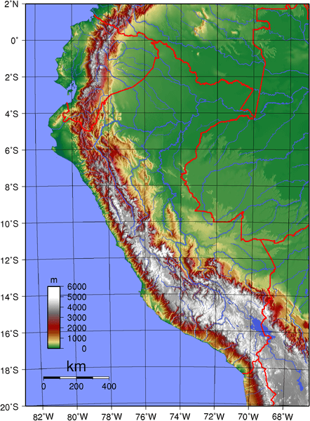
Topographic map of Peru.
Major Peaks of Peru
Peru's Highest Summits
Cordillera Blanca:
- Huascarán Sur: 6,768 m (22,205 ft) - Peru's highest peak
- Huascarán Norte: 6,654 m (21,831 ft)
- Yerupajá: 6,635 m (21,768 ft) - Cordillera Huayhuash
- Coropuna: 6,377 m (20,922 ft)
- Alpamayo: 5,947 m (19,511 ft) - "Most beautiful mountain in the world"
- Artesonraju: 6,025 m (19,767 ft)
- Chopicalqui: 6,354 m (20,846 ft)
- Huandoy: 6,395 m (20,981 ft)
Cordillera Huayhuash:
- Yerupajá: 6,635 m (21,768 ft)
- Siula Grande: 6,344 m (20,814 ft)
- Jirishanca: 6,094 m (19,993 ft)
- Rondoy: 5,870 m (19,259 ft)
Cordillera Vilcanota:
- Ausangate: 6,384 m (20,945 ft)
- Colque Cruz: 6,102 m (20,020 ft)
- Chumpe: 6,106 m (20,033 ft)
Cordillera Occidental:
- Coropuna: 6,377 m (20,922 ft)
- Ampato: 6,288 m (20,630 ft)
- Sabancaya: 5,967 m (19,577 ft) - Active volcano
- Misti: 5,822 m (19,101 ft)
Other Notable Peaks:
- Salcantay: 6,271 m (20,574 ft)
- Huayna Potosí: 6,088 m (19,974 ft)
- Chachani: 6,057 m (19,872 ft)
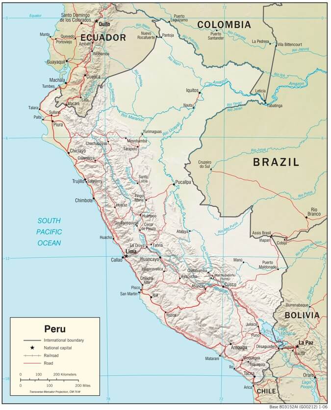
Peru physiographic map.