Chile's Islands and Archipelagos: From Pacific Outposts to Patagonian Wilderness
Situated along the rugged Pacific coast of South America, Chile stands as a land of remarkable contrasts and natural wonders. Beyond its towering Andean peaks and arid deserts, Chile is also home to a diverse and captivating collection of islands and archipelagos that dot its expansive coastline.
")


 https://www.flickr.com/photos/hbarrison/39068564975/in/album-72157665107438038/")

From Easter Island to Cape Horn: Chile's Pacific Island Heritage
Chile's dramatic Pacific coastline, stretching across nearly 4,270 kilometers (2,653 miles) from the Atacama Desert to the subantarctic waters of Cape Horn, encompasses one of South America's most extensive and diverse collections of islands and archipelagos. This maritime realm reflects the country's remarkable geographical contrasts, from remote Polynesian outposts lost in the Pacific's immensity to the glacier-carved fjords of Patagonia's labyrinthine waterways. Each island group tells a unique story of volcanic origins, cultural heritage, and ecological adaptation, collectively forming a maritime nation within a nation.
The Oceanic Frontier: Easter Island and Pacific Territories
In the vast expanse of the South Pacific, approximately 3,700 kilometers (2,300 miles) from the Chilean mainland, lies Rapa Nui, known internationally as Easter Island. This triangular volcanic island, covering 164 square kilometers (63 square miles), represents one of the world's most isolated inhabited territories and serves as the easternmost point of the Polynesian cultural triangle. The island's 887 monumental moai statues, carved between 1250 and 1500 CE, stand as silent guardians over rolling grasslands that once supported dense palm forests before human settlement and subsequent ecological collapse.
The island's geology reflects its volcanic origins, with three extinct volcanic cones—Rano Raraku, Terevaka, and Rano Kau—dominating the landscape. Terevaka, the highest peak at 507 meters (1,663 feet), anchors the northern portion of the island, while the ceremonial village of Orongo perches dramatically on the rim of Rano Kau crater, overlooking the Pacific and the offshore islets of Motu Nui, Motu Iti, and Motu Kaokao. These rocky outcrops played a crucial role in the annual Tangata Manú (Birdman) competition that once determined political leadership among the Rapa Nui people.
Closer to the mainland but equally remote, the Juan Fernández Archipelago lies approximately 600 kilometers (373 miles) off the Chilean coast, comprising three volcanic islands that rise dramatically from abyssal Pacific depths. Isla Robinson Crusoe, covering 93 square kilometers (36 square miles), and Isla Alejandro Selkirk, spanning 85 square kilometers (33 square miles), form the archipelago's main landmasses, along with the tiny Isla Santa Clara. The archipelago gained worldwide fame through the story of Scottish sailor Alexander Selkirk, marooned on Más a Tierra (now Robinson Crusoe Island) from 1704 to 1709, whose survival tale inspired Daniel Defoe's Robinson Crusoe.
These islands represent evolutionary laboratories of extraordinary significance, with over 60% of their plant species found nowhere else on Earth. The endemic Juan Fernández fire crown hummingbird (Sephanoides fernandensis) and the critically endangered Juan Fernández fur seal (Arctocephalus philippii) exemplify the archipelago's unique biodiversity. The dramatic topography, with peaks reaching 1,650 meters (5,413 feet) on Robinson Crusoe Island, creates diverse microclimates that support temperate rainforests, alpine shrublands, and coastal grasslands within remarkably small areas.
Further north, the Desventuradas Islands ("Islands of the Unfortunate Ones") lie approximately 850 kilometers (530 miles) northwest of Santiago, comprising San Félix, San Ambrosio, González, and Roca Catedral islands. These small volcanic outcrops, totaling just 5 square kilometers (1.9 square miles), serve as crucial stepping stones for marine life across the vast Pacific and support important seabird colonies despite their harsh, desert-like conditions.
The Chiloé Cultural Heartland
The Chiloé Archipelago, positioned in southern Chile's inland sea, represents the country's most culturally distinctive island region. The archipelago comprises over 40 islands, with Isla Grande de Chiloé serving as the cultural and geographic centerpiece. At 8,394 square kilometers (3,241 square miles), Chiloé Island ranks as Chile's second-largest island and South America's fifth-largest, supporting a population of approximately 170,000 inhabitants whose traditions blend Indigenous Huilliche heritage with Spanish colonial influences.
The archipelago's unique geography, protected from Pacific storms by the Chilean mainland, has fostered the development of distinctive architectural traditions, including the famous palafitos—colorful houses built on stilts over the water—and sixteen wooden churches that collectively earned UNESCO World Heritage status. These churches, constructed between the 17th and 19th centuries by Jesuit missionaries and local artisans using Indigenous building techniques, represent a remarkable fusion of European and native architectural traditions adapted to the region's humid climate and seismic activity.
Chiloé's cultural landscape extends beyond its built environment to encompass rich maritime traditions, including the cultivation of native potatoes—the archipelago harbors over 400 varieties of this globally important crop. The surrounding waters support thriving salmon aquaculture operations and traditional shellfish harvesting, while the islands' temperate rainforests harbor endemic species such as the Chiloé wigeon (Mareca sibilatrix) and provide habitat for the elusive pudú (Pudu puda), the world's smallest deer species.
The Southern Wilderness: Tierra del Fuego and Patagonian Archipelagos
At Chile's southern extremity, the Tierra del Fuego Archipelago presents some of the world's most dramatic and pristine wilderness landscapes. The archipelago covers 73,746 square kilometers (28,473 square miles), with approximately two-thirds under Chilean sovereignty, including the western portion of Isla Grande and numerous smaller islands scattered across the region's complex geography of fjords, channels, and straits.
Wellington Island, covering 5,556 square kilometers (2,145 square miles), ranks as Chile's third-largest island and exemplifies the region's wild character. Most of the island lies within Bernardo O'Higgins National Park, protecting vast expanses of subpolar forests dominated by southern beech (Nothofagus species) and providing habitat for guanacos (Lama guanicoe), Andean condors (Vultur gryphus), and marine mammals including elephant seals (Mirounga leonina). The island's only permanent settlement, Puerto Edén, is home to the last community of Kawésqar people, an Indigenous maritime nomadic group whose traditional lifestyle exemplifies millennia of adaptation to Patagonia's challenging environment.
Navarino Island, situated south of the Beagle Channel, holds the distinction of being the world's southernmost inhabited island. The island supports Puerto Williams, officially recognized as the world's southernmost city, which serves as a base for Antarctic expeditions and scientific research. The surrounding waters of the Beagle Channel, named after Darwin's famous voyage aboard HMS Beagle, provide critical habitat for marine mammals and seabirds while offering spectacular scenery of glacier-carved mountains rising directly from sea level to elevations exceeding 1,000 meters (3,281 feet).
The Diego Ramírez Islands, lying 108 kilometers (67 miles) southwest of Cape Horn, represent Chile's southernmost territorial extent. These uninhabited rocky islets, constantly battered by the notorious winds and waves of the Drake Passage, serve as important breeding grounds for black-browed albatrosses (Thalassarche melanophris) and southern giant petrels (Macronectes giganteus), while also supporting the world's southernmost kelp forests.
Patagonian Fjordlands and Archipelagos
The intricate waterways of Chile's Patagonian coast harbor numerous archipelagos that reflect the region's complex glacial history. The Guaitecas Archipelago, located in the Aysén Region, comprises dozens of forested islands separated by deep fjords and channels that provide sheltered navigation routes through otherwise treacherous waters. These islands support traditional communities engaged in fishing, aquaculture, and selective timber harvesting, while their surrounding waters serve as nursery areas for commercially important fish species.
The Chonos Archipelago, named after the Indigenous Chono people who once navigated these waters in dalca canoes, extends southward through a maze of islands, channels, and fjords that challenge even experienced mariners. The archipelago's pristine wilderness provides critical habitat for marine mammals, including Chilean dolphins (Cephalorhynchus eutropia) and South American fur seals (Arctocephalus australis), while its remote location has preserved traditional ecological knowledge among the few remaining Indigenous communities.
Central Coast Islands and Marine Reserves
Chile's central coast features several important islands that serve as marine wildlife refuges and research stations. Isla Mocha, located 34 kilometers (21 miles) off the coast near Arauco, covers 52 square kilometers (20 square miles) of rolling hills and native forests that provide habitat for numerous endemic plant species and serve as an important stopover for migratory birds. The island's designation as a national reserve protects its unique ecosystems while supporting limited ecotourism activities.
The Penguin Natural Monument, comprising Magdalena and Marta islands near Punta Arenas, represents one of Chile's most accessible wildlife spectacles. These small islands support the largest continental colony of Magellanic penguins (Spheniscus magellanicus) in Chile, with over 120,000 breeding pairs returning annually between September and March. The surrounding waters also provide habitat for South American sea lions (Otaria flavescens), imperial cormorants (Leucocarbo atriceps), and various gull species.
Geological Origins and Environmental Challenges
Chile's islands reflect the country's position along the Pacific Ring of Fire, with most formations resulting from volcanic activity associated with the subduction of oceanic plates beneath the South American continental margin. The Juan Fernández and Desventuradas islands exemplify oceanic volcanism, rising from seafloor depths exceeding 4,000 meters (13,123 feet), while the Patagonian archipelagos result from glacial carving and post-glacial rebound following the retreat of the Patagonian ice sheets.
Climate change poses significant challenges to these island ecosystems, with rising sea temperatures affecting marine food webs, changing precipitation patterns altering terrestrial vegetation, and sea-level rise threatening low-lying coastal areas. The isolation of many Chilean islands makes their endemic species particularly vulnerable to climate change impacts, while introduced species continue to threaten native biodiversity on several archipelagos.
Conservation and Cultural Preservation
Chile has established an extensive network of protected areas covering its most important islands and archipelagos, including national parks, national reserves, and marine protected areas. The Juan Fernández Islands Biosphere Reserve, designated by UNESCO in 1977, protects the archipelago's unique terrestrial and marine ecosystems, while the recently established Juan Fernández Marine Park covers over 262,000 square kilometers (101,158 square miles) of surrounding ocean.
Cultural preservation efforts focus particularly on maintaining Indigenous traditions among the Kawésqar people of Wellington Island and the Rapa Nui of Easter Island, whose languages and traditional ecological knowledge face ongoing threats from globalization and cultural assimilation. The Chilean government has implemented various programs to support Indigenous rights and cultural preservation, while also promoting sustainable tourism that respects both environmental and cultural sensitivities.
Economic Significance and Tourism
Chile's islands contribute significantly to the national economy through aquaculture, fishing, tourism, and research activities. The salmon farming industry, concentrated primarily around Chiloé and the Patagonian fjords, represents one of Chile's most important export sectors, though it faces ongoing challenges related to environmental sustainability and disease management.
Ecotourism continues to grow in importance, with visitors drawn to the unique wildlife, pristine landscapes, and cultural heritage of Chile's island territories. Easter Island receives over 100,000 visitors annually despite its remote location, while the Juan Fernández Islands attract adventure travelers and researchers interested in their unique ecosystems and Robinson Crusoe connections.
Conclusion
Chile's islands and archipelagos represent far more than scattered landmasses in the vast Pacific; they constitute integral components of the nation's territorial identity, cultural heritage, and ecological wealth. From the mysterious moai of Easter Island to the pristine wilderness of the Patagonian fjords, from the endemic species of the Juan Fernández Islands to the traditional communities of Chiloé, these maritime territories embody Chile's remarkable diversity and its responsibilities as a steward of unique Pacific ecosystems.
As Chile advances through the 21st century, the sustainable management of these island territories becomes increasingly critical for maintaining biodiversity, supporting traditional communities, and addressing the challenges of climate change. The delicate balance between conservation, cultural preservation, and economic development will determine whether future generations can continue to experience the extraordinary natural and cultural wealth that defines Chile's island heritage.
The success of Chile's island conservation efforts carries implications far beyond national borders, as these territories serve as refuges for globally significant species, repositories of Indigenous knowledge, and natural laboratories for understanding evolutionary processes and the impacts of climate change. In protecting and celebrating its island heritage, Chile affirms its commitment to preserving some of the Pacific's last pristine wilderness areas for the benefit of both present and future generations.
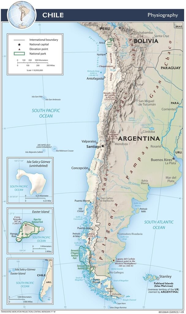
Chile physiographic map.