The Geography of Venezuela: A Land of Extraordinary Contrasts
Venezuela stands as one of South America's most geographically diverse nations, situated on the continent's northern coast. This country of remarkable contrasts encompasses towering mountain peaks, vast tropical plains, dense rainforests, and extensive Caribbean coastlines.


 - via Wikipedia")


From the Andes to the Orinoco: Understanding Venezuela's Diverse Landscapes
Venezuela, officially known as the Bolivarian Republic of Venezuela, stands as one of South America's most geographically diverse nations. Situated on the continent's northern coast, this country of remarkable contrasts encompasses towering mountain peaks, vast tropical plains, dense rainforests, and extensive Caribbean coastlines. With a total area of 912,050 square kilometers (352,144 square miles), Venezuela is roughly twice the size of California and ranks as the world's 33rd largest country by land area.
The nation's geographic diversity is extraordinary, ranging from snow-capped Andean peaks that rise above 4,900 meters (16,076 feet) to vast seasonal wetlands and ancient geological formations that date back billions of years. This remarkable variety of landscapes has created equally diverse ecosystems, making Venezuela one of the world's megadiverse countries. The country's strategic position serves as a natural bridge between the Caribbean and South America, while its subsurface wealth includes the world's largest proven petroleum reserves, profoundly shaping national development.
Location and Boundaries
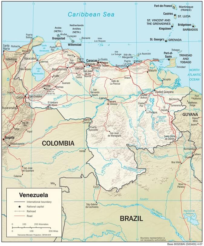
Venezuela occupies a strategic position in northern South America, bordered by the Caribbean Sea to the north, Guyana to the east, Brazil to the south, and Colombia to the west and southwest. The country's northern coastline stretches for approximately 2,800 kilometers (1,740 miles) along the Caribbean Sea, providing access to numerous islands and extensive maritime territory. This coastal position has historically made Venezuela a crucial gateway between the Caribbean and South America.
The nation's borders encompass significant geographic and political complexity. The eastern boundary with Guyana includes the disputed Essequibo region, a territory of about 159,500 square kilometers (61,600 square miles) that Venezuela claims as its own. To the south, Venezuela shares its longest border with Brazil, extending for 2,200 kilometers (1,367 miles) through largely uninhabited Amazon rainforest. The western border with Colombia, spanning 2,050 kilometers (1,274 miles), traverses diverse terrain, ranging from coastal lowlands to high mountain peaks.
Physical Geography and Topography
Venezuela's physical landscape can be divided into four distinct geographic regions, each with unique characteristics that contribute to the country's remarkable environmental diversity.
The Guiana Highlands
The Guiana Highlands, known locally as the Macizo Guayanés, occupy nearly half of Venezuela's territory in the south and east. This ancient geological formation, consisting primarily of Precambrian rocks over two billion years old, represents one of Earth's oldest land surfaces. The region is characterized by dramatic tepuis—flat-topped mountain formations that rise abruptly from the surrounding landscape, resembling natural skyscrapers.
The most famous of these tepuis is Mount Roraima, reaching 2,810 meters (9,219 feet) above sea level at Venezuela's border with Brazil and Guyana. These isolated mountain tops, often shrouded in clouds, harbor unique ecosystems that are home to high levels of endemic species. The highlands are also home to Angel Falls, the world's highest uninterrupted waterfall, plunging 979 meters (3,212 feet) from the Auyán-tepui plateau.
The Maracaibo Lowlands
In Venezuela's northwest corner lies the Maracaibo Basin, a low-lying region surrounding Lake Maracaibo, the largest lake in South America. This body of water covers approximately 13,210 square kilometers (5,100 square miles) and reaches depths of up to 60 meters (197 feet). The lake is technically a tidal bay connected to the Gulf of Venezuela by a narrow strait, which allows for the mixing of fresh and saltwater.
The Maracaibo Lowlands are characterized by a hot, humid tropical climate and extensive oil deposits that have made this region the foundation of Venezuela's petroleum-based economy. The surrounding lowlands rarely exceed 100 meters (328 feet) above sea level and are crossed by numerous rivers flowing down from the surrounding mountains.
The Andean Region
The Venezuelan Andes represent the northern extension of the great Andean mountain chain that runs along South America's western edge. These mountains enter Venezuela from Colombia and form two primary ranges: the Sierra de Perijá, located along the Colombian border, and the Cordillera de Mérida, which extends northeast toward the Caribbean coast.
Pico Bolívar, Venezuela's highest point at 4,978 meters (16,332 feet), stands in the Cordillera de Mérida near the city of Mérida. This peak, along with several others exceeding 4,500 meters (14,764 feet), supports small glaciers and alpine ecosystems unique to tropical latitudes. The Andean region experiences a temperate climate due to its elevation, with temperatures varying dramatically with altitude rather than season.
The Llanos
The vast Llanos occupy Venezuela's central region, forming part of the extensive Orinoco River basin. These tropical grasslands stretch across approximately 300,000 square kilometers (115,830 square miles) of gently rolling plains, with elevations rarely exceeding 200 meters (656 feet) above sea level. The region experiences distinct wet and dry seasons, characterized by dramatic seasonal flooding that transforms the landscape from parched grasslands to vast temporary wetlands.
The Llanos serve as Venezuela's primary cattle-raising region and are crossed by numerous rivers flowing north and east toward the Orinoco. This region's seasonal flooding creates one of South America's most important wildlife habitats, supporting massive populations of waterbirds, caimans, and other wetland species.
Physiographic map of Venezuela.
Climate and Weather Patterns
Venezuela's location just north of the equator, combined with its diverse topography, creates a complex array of climate zones ranging from tropical coastal areas to temperate mountain highlands. The country experiences two primary seasons: a wet season from May to October and a dry season from November to April.
Coastal regions typically receive between 400 and 1,000 millimeters (16 to 39 inches) of annual rainfall, while mountainous areas may receive over 3,000 millimeters (118 inches) per year. Temperatures vary primarily with elevation rather than with the seasons. Coastal areas maintain year-round temperatures between 26 °C and 28°C (79°F and 82°F), while mountain areas can experience temperatures near freezing at the highest elevations.
The Llanos experience the most dramatic seasonal variation, with annual rainfall ranging between 1,000 and 2,000 millimeters (39 to 79 inches), concentrated almost entirely during the wet season. During the dry season, many areas become parched and dusty, while the wet season transforms the same regions into vast seasonal wetlands.
Hydrography and River Systems
Venezuela's river systems are dominated by the Orinoco River, one of South America's longest rivers at 2,140 kilometers (1,330 miles). The Orinoco originates in the Guiana Highlands near the Brazilian border. It flows in a great arc across the country before emptying into the Atlantic Ocean through a vast delta system covering over 40,000 square kilometers (15,444 square miles).
The Orinoco basin drains approximately 80 percent of Venezuela's territory, collecting water from hundreds of tributaries flowing down from the surrounding highlands and mountains. Major tributaries include the Caroní, Apure, Arauca, and Meta rivers. The Caroní River is particularly significant as it provides hydroelectric power through a series of massive dams, including the Guri Dam, one of the world's largest hydroelectric installations.
In the northwest, rivers flow into Lake Maracaibo and ultimately to the Caribbean Sea. The lake receives water from numerous rivers descending from the surrounding mountains, including the Catatumbo River, famous for the meteorological phenomenon known as Catatumbo lightning.
Natural Resources and Geology
Venezuela possesses extraordinary mineral wealth, most notably the world's largest proven petroleum reserves. These oil deposits, primarily located in the Maracaibo Basin and the Orinoco Belt, contain an estimated 300 billion barrels of recoverable crude oil. The country also holds significant natural gas reserves, estimated at over 200 trillion cubic feet.
Beyond hydrocarbons, Venezuela contains substantial deposits of iron ore in the Guiana Highlands, particularly around the Cerro Bolívar area. The country also possesses significant reserves of bauxite, gold, diamonds, and coal. The Guiana Highlands contain some of the world's oldest geological formations, with rocks dating back over 3.8 billion years.
The diverse geology has created varied soil types across the country. The Llanos feature fertile alluvial soils deposited by seasonal flooding, while the Guiana Highlands contain nutrient-poor soils typical of ancient geological formations. Mountain areas often have thin, rocky soils, while coastal regions feature sandy soils mixed with sediments from major rivers.
Biodiversity and Ecosystems
Venezuela's geographic diversity supports extraordinary biodiversity, ranking among the world's most biodiverse countries. The nation contains portions of three major South American biomes: the Amazon rainforest, the Atlantic Forest, and the Llanos grasslands. This diversity of ecosystems supports over 21,000 plant species, 1,400 bird species, 350 mammal species, and countless insects and other invertebrates.
The Amazon region in southern Venezuela harbors dense tropical rainforest with extraordinary species diversity. Many areas remain unexplored and likely contain undiscovered species. The tepuis of the Guiana Highlands support unique island-like ecosystems with high levels of endemism, where species have evolved in isolation for millions of years.
The Llanos ecosystem supports a diverse array of species adapted to seasonal flooding and drought cycles. During the wet season, this region becomes one of South America's most important wildlife refuges, supporting massive populations of waterbirds, including ibises, herons, and storks. The area also supports populations of capybaras, caimans, and jaguars.
Human Geography and Settlement Patterns
Venezuela's population of approximately 28 million people is distributed unevenly across the country's diverse geography. Nearly 90 percent of Venezuelans live in urban areas, with the majority concentrated in the northern coastal and mountain regions. The capital city of Caracas, situated in a mountain valley approximately 900 meters (2,953 feet) above sea level, is home to over 3 million people within its metropolitan area.
The coastal region is home to most of Venezuela's major cities, including Maracaibo (1.5 million), Valencia (1.4 million), and Barquisimeto (1.2 million). These urban centers developed due to favorable climate conditions, access to transportation networks, and proximity to economic opportunities. The northern mountain valleys provide temperate climates that have attracted settlement since pre-Columbian times.
In contrast, vast areas of southern Venezuela remain sparsely populated. The entire Guiana Highlands region, comprising nearly half the country's territory, contains less than 5 percent of the population. These areas are inhabited primarily by Indigenous groups and small settlements engaged in mining or research activities.
Environmental Challenges and Conservation
Venezuela faces significant environmental challenges related to its geography and economic development. Rapid urbanization has created significant environmental pressures around major cities, while oil extraction has led to pollution in sensitive ecosystems. Deforestation in the Amazon region, though less severe than in neighboring countries, remains a concern.
Climate change poses particular challenges for Venezuela's mountain ecosystems. The country's remaining glaciers are rapidly retreating, and scientists predict that they may disappear entirely within the next few decades. Changes in precipitation patterns could significantly affect the seasonal flooding cycles that many Llanos species depend upon.
The government has established an extensive network of national parks and protected areas covering over 15 percent of the national territory. These protected areas encompass portions of all major ecosystem types, ranging from Caribbean coastal regions to the Amazon rainforest. However, enforcement of environmental protections faces challenges due to limited resources and economic pressures.
Economic Geography
Venezuela's economic geography has been dominated by petroleum resources concentrated in the Maracaibo Basin and Orinoco Belt. This geographic concentration of oil wealth has significantly shaped national development patterns, with major infrastructure and population centers emerging in close proximity to petroleum resources and export facilities.
Agriculture remains important in specific geographic regions, with coffee cultivation in mountain areas, cattle ranching in the Llanos, and various crops in fertile valley areas. The Maracaibo Lowlands support both petroleum extraction and agricultural activities, while the Orinoco Delta region supports some rice cultivation and fishing.
The geographic isolation of much of Venezuela's territory has limited economic development in many regions. The southern Guiana Highlands, despite containing significant mineral resources, remain largely undeveloped due to difficult terrain and limited transportation infrastructure.
Transportation and Infrastructure
Venezuela's diverse geography presents significant challenges for the development of transportation and infrastructure. The country's highway system connects major population centers in the north but provides limited access to southern regions. The Trans-Amazonian Highway system provides some connectivity to remote areas, but many regions remain accessible only by air or river transport.
The Orinoco River serves as a vital transportation corridor, enabling navigation by large vessels for hundreds of kilometers inland. Lake Maracaibo similarly offers water transportation, although its shallow depth limits the size of vessels. Mountain areas are served by winding highways that must navigate challenging terrain and elevation changes.
Conclusion
Venezuela's geography represents one of South America's most diverse and complex territorial arrangements. From the ancient tepuis of the Guiana Highlands to the seasonal wetlands of the Llanos, from the snow-capped peaks of the Andes to the tropical coastlines of the Caribbean, this nation encompasses an extraordinary range of environmental diversity within its borders.
This geographic diversity has profoundly shaped Venezuelan society, economy, and culture. The concentration of petroleum resources has driven economic development, while the variety of ecosystems supports remarkable biodiversity. The challenges posed by difficult terrain and climate variations continue to influence settlement patterns and development strategies.
Understanding Venezuela's geography is essential for comprehending the country's past, present, and future. The nation's natural wealth and environmental diversity provide both opportunities and challenges that will continue to influence Venezuelan development for generations to come. As global climate change and economic pressures continue to evolve, Venezuela's unique geographic characteristics will play an increasingly important role in determining the country's trajectory in the 21st century.