The Geography of Uruguay: From the Pampas to the Atlantic
Uruguay, officially the Oriental Republic of Uruguay, is one of South America's most geographically unique countries. Although it is the continent's second-smallest nation after Suriname, Uruguay's strategic position and distinct topography have significantly influenced its history, culture, and economy.
 https://www.flickr.com/photos/marcelocampi/26080691025")

 - via Wikimedia Commons")

 https://www.flickr.com/photos/ciat/6809968788")

The Oriental Republic of Uruguay: A Geographic Portrait of South America's Hidden Gem
Uruguay, officially known as the Oriental Republic of Uruguay (República Oriental del Uruguay), stands as one of the most geographically distinctive nations in South America. Despite being the continent's second-smallest country after Suriname, Uruguay's strategic location and unique topographical features have profoundly shaped its history, culture, and economic development. Nestled between the geographic giants of Brazil and Argentina, this nation, spanning 176,215 square kilometers (68,037 square miles), presents a fascinating case study in how geography influences national character and destiny.
Location and Boundaries
Uruguay occupies a privileged position on South America's southeastern coast, where the continent meets the South Atlantic Ocean. As an integral part of the Southern Cone of South America—the region encompassing Argentina, Chile, Uruguay, and southern Brazil—the country benefits from the temperate climate and geographic characteristics that distinguish this area from the rest of tropical South America. Uruguay is strategically positioned between 30° and 35° South latitude and 53° and 58° West longitude, placing it entirely within the temperate zone of the Southern Hemisphere. This location grants Uruguay a moderate climate that distinguishes it from many of its continental neighbors.
The nation's borders tell the story of colonial competition and geographic logic. To the north and northeast, Uruguay shares a 1,068-kilometer (664-mile) border with Brazil, marked primarily by rivers and artificial boundaries established through diplomatic negotiations. The western boundary with Argentina extends for 580 kilometers (360 miles), defined largely by the Uruguay River, which gave the country its name. The southern and eastern edges of the country embrace 660 kilometers (410 miles) of South Atlantic coastline, providing Uruguay with extensive maritime resources and commercial opportunities.
The total land area of 175,015 square kilometers (67,574 square miles) makes Uruguay roughly equivalent in size to the U.S. state of Washington or slightly larger than the combined areas of England and Wales. This compact size has contributed to the country's political stability and cultural cohesion, as no point within Uruguay lies more than 300 kilometers (186 miles) from the capital, Montevideo.
Topographical Features and Terrain
Uruguay's topography defies the dramatic extremes found elsewhere in South America. Rather than towering peaks or vast lowlands, the country is characterized by gentle, rolling plains punctuated by low hills and extensive river valleys. This landscape, locally known as the "Purple Land" due to the violet hues that wildflowers cast across the grasslands during certain seasons, is home to some of the world's finest natural pasturelands.
The highest point in Uruguay is Cerro Catedral, reaching a modest 514 meters (1,686 feet) above sea level in the Cuchilla Grande range. This elevation, while unimpressive by continental standards, provides commanding views across the surrounding countryside and serves as a symbolic high point for the nation. The country's lowest elevation occurs at sea level along the Atlantic coast, creating a gentle gradient that facilitates natural drainage and prevents the formation of extensive wetlands.
The terrain can be broadly divided into three main regions. The southern coastal plains extend inland from the Atlantic Ocean and the Río de la Plata, characterized by low, fertile lands that are ideal for agriculture and urban development. The central hill country features the gently undulating landscape that defines much of Uruguay's interior, with elevations rarely exceeding 300 meters (984 feet). The northern plains merge gradually with the Brazilian Highlands, creating a transition zone of slightly more rugged terrain.
This gentle topography has had profound implications for Uruguay's development. The absence of significant mountain barriers has facilitated internal communication and transportation, contributing to national unity. The predominance of grasslands has made Uruguay one of the world's premier livestock-raising regions, earning it recognition as a major exporter of beef, wool, and dairy products.
Hydrography and Water Resources
Water defines Uruguay's geography in both obvious and subtle ways. The country's very name derives from the Uruguay River, and water bodies form most of its international boundaries while providing essential resources for agriculture, industry, and daily life.
The Uruguay River system dominates the country's western hydrography. This major waterway, which forms the boundary with Argentina, stretches approximately 500 kilometers (311 miles) along Uruguay's western edge. The river is navigable for ocean-going vessels up to Paysandú, making it a crucial transportation artery for international commerce. Major tributaries include the Río Negro, which flows east-west across the country's center, creating the largest internal waterway and serving as a natural divider between Uruguay's northern and southern regions.
The Río de la Plata, technically an estuary rather than a river, forms Uruguay's southern aquatic boundary with Argentina. This massive body of water, 290 kilometers (180 miles) wide at its mouth, creates a maritime highway that has connected Uruguay to global commerce since colonial times. The estuary's muddy, brackish waters reflect the enormous volume of sediment carried by the Paraná and Uruguay rivers, creating fertile conditions for both marine life and coastal agriculture.
Along the Atlantic coast, numerous small rivers and streams create a network of lagoons and wetlands. The most significant of these is Laguna Merín, which Uruguay shares with Brazil in the northeast. This large freshwater lagoon, covering approximately 3,750 square kilometers (1,448 square miles), with Uruguay controlling about 40% of its area, supports important fisheries and provides habitat for a diverse range of wildlife species.
Uruguay's water resources extend beyond surface features to include significant groundwater reserves. The Guaraní Aquifer, one of the world's largest freshwater aquifer systems, extends beneath portions of Uruguay, providing a strategic water reserve shared with Argentina, Brazil, and Paraguay. This underground resource ensures the nation's long-term water security.
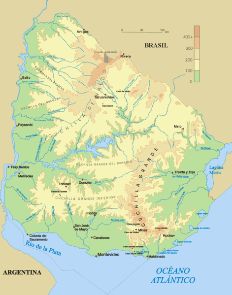
Topographical map of Uruguay.
Climate and Weather Patterns
Uruguay enjoys a temperate climate, one of South America's most moderate and pleasant weather regimes. The country's position entirely within the temperate zone, combined with maritime influences from the Atlantic Ocean and Río de la Plata, creates conditions that avoid the extremes common elsewhere on the continent.
The climate is classified as humid subtropical, with four distinct seasons that mirror those of the Northern Hemisphere's temperate regions, although they occur at opposite times of the year. Summer (December to March) brings warm temperatures, averaging 22°C to 28°C (72°F to 82°F), with occasional heatwaves pushing temperatures above 35°C (95°F). The coastal influence moderates these extremes, making summer heat more bearable than in continental interiors.
Winter (June to September) is mild by global standards, with average temperatures ranging from 6°C to 14°C (43°F to 57°F). Snow is extremely rare, occurring perhaps once every decade in the interior and rarely along the coast. Frost occurs regularly in winter, particularly in the interior regions, but seldom causes significant agricultural damage due to the timing and brief duration of freezing conditions.
Precipitation patterns reflect the country's position at the intersection of different air mass systems. Annual rainfall averages between 1,000 and 1,400 millimeters (39 to 55 inches), distributed relatively evenly throughout the year with slight peaks in autumn and spring. This consistent moisture, combined with moderate temperatures, creates ideal conditions for grassland growth, supporting Uruguay's agricultural economy.
The country is significantly influenced by global weather patterns, particularly the El Niño-Southern Oscillation (ENSO). El Niño years typically bring increased rainfall and flooding risks, while La Niña periods can result in drought conditions that challenge agriculture and hydroelectric power generation. These variations add an element of unpredictability to Uruguay's otherwise stable climate.
Wind patterns play a crucial role in Uruguay's weather systems. The predominant winds blow from the east and southeast, bringing maritime moisture inland. The famous "pampero" winds, cold, dry air masses that sweep up from the southwest, can cause dramatic temperature drops and clear skies after periods of humid weather. These winds, while sometimes destructive, help moderate the climate and prevent prolonged periods of oppressive humidity.
Natural Resources and Environmental Geography
Uruguay's natural resource endowment reflects its geographic characteristics, with extensive grasslands and water resources forming the foundation of the national economy. The country's most valuable natural asset is undoubtedly its soil, particularly the fertile plains that support world-class livestock operations and increasingly diverse agricultural production.
The soils of Uruguay developed over millennia from the weathering of ancient crystalline rocks and the accumulation of sediments from neighboring regions. The predominant soil types include fertile Mollisols in the south and west, which are ideal for crop production, and Vertisols in the north, which support excellent pasture growth despite challenges related to drainage and workability. These soils, combined with favorable climate conditions, create some of the world's most productive natural grasslands.
Mineral resources in Uruguay are limited, but they are locally significant. The country possesses small deposits of iron ore, manganese, and other metals, though none have supported major mining operations. More important are construction materials, including granite, marble, and sand, which support domestic construction industries. Recent exploration has identified potential for precious metals and rare Earth elements, though commercial exploitation remains limited.
Uruguay's forest resources represent both a natural heritage and an economic opportunity. Historically, the country was characterized by grasslands with scattered gallery forests along rivers. However, extensive afforestation programs have dramatically increased forest cover. Eucalyptus and pine plantations now cover approximately 1.8 million hectares (4.4 million acres), supporting a growing forestry industry focused on pulp production and timber exports.
The marine environment offers a wealth of significant biological resources. Uruguay's Atlantic waters support important fisheries, including populations of hake, croaker, and anchovies. The meeting of warm Brazil Current and cold Malvinas Current waters off Uruguay's coast creates particularly productive marine conditions. Coastal lagoons and estuaries serve as nursery areas for numerous fish species and support small-scale artisanal fisheries.
Regional Geographic Divisions
Uruguay's compact size might suggest geographic uniformity, but the country displays distinct regional characteristics that reflect variations in topography, climate, and economic activity. These regional differences, while subtle compared to those found in larger countries, have important implications for land use, settlement patterns, and economic development.
The Litoral region, encompassing the southwestern departments bordering the Uruguay River and Río de la Plata, represents Uruguay's most developed and densely populated area. This region includes Montevideo, the national capital and economic center, which is home to nearly half of the country's population. The Litoral benefits from excellent transportation connections, port facilities, and proximity to Buenos Aires, making it the natural focus for commerce and industry. The flat to gently rolling terrain and fertile soils support intensive agriculture, including market gardening and dairy farming that supply urban populations.
The Interior region covers the central and northern portions of the country, characterized by the gently rolling hills and extensive grasslands that epitomize Uruguay's landscape. This region serves as the heartland of the country's livestock economy, with cattle and sheep ranching being the dominant land use. The terrain is ideal for extensive grazing systems, and the region maintains a traditional gaucho culture that plays a significant role in Uruguayan national identity. Towns in the Interior tend to be smaller and more widely spaced, serving as commercial centers for surrounding agricultural areas.
The Coastal region extends along the Atlantic Ocean and includes some of Uruguay's most scenic and economically important territory. This area encompasses the premier beach resorts of Punta del Este and other coastal towns that drive Uruguay's important tourism industry. The coastal climate is moderated by maritime influences, making it attractive for both permanent residence and vacation homes. Agriculture in coastal areas often focuses on specialized crops that benefit from the mild climate and proximity to transportation networks.
The Northern region, bordering Brazil, displays the most continental characteristics of any part of Uruguay. This area experiences slightly greater temperature extremes and supports extensive cattle ranching on large estancias. The region's economy is closely linked to cross-border trade with Brazil, and Portuguese cultural influences are more evident than elsewhere in Uruguay. The gently rolling terrain continues the pattern found throughout the country, but elevations tend to be slightly higher, and the landscape exhibits a more pronounced influence from the Brazilian Highlands.
Human Geography and Settlement Patterns
The distribution of Uruguay's 3.5 million inhabitants reflects the powerful influence of geography on human settlement patterns. The country displays one of South America's most extreme examples of urban primacy, with the Montevideo metropolitan area housing approximately 1.9 million people, or roughly 55% of the national population. This concentration results from geographic factors, including the capital's excellent natural harbor, its strategic location on the Río de la Plata, and its position as the natural hub of the country's transportation networks.
The coastal location of Montevideo exemplifies the significant role geography plays in urban development. Founded in 1726 on a natural harbor protected by Cerro de Montevideo, the city grew as a commercial and administrative center serving the fertile hinterlands of the Río de la Plata region. The city's geography includes a series of low hills and coastal plains that have guided urban expansion, while the harbor remains central to the national economy.
Outside Montevideo, Uruguay's settlement pattern reflects the country's agricultural geography. The Interior regions support a network of small to medium-sized cities that serve as commercial and service centers for the surrounding agricultural areas. Cities like Salto, Paysandú, and Rivera grew at strategic locations along major rivers or near border crossings, demonstrating how physical geography continues to influence urban development.
The coastal geography has created unique settlement opportunities that distinguish Uruguay from many of its neighbors. Beach communities along the Atlantic coast, particularly around Punta del Este, have evolved into significant urban centers that cater to both permanent residents and seasonal populations. These communities represent successful adaptation to coastal geography and demonstrate how natural amenities can drive economic development.
Rural settlement patterns in Uruguay reflect both the country's topography and its agricultural economy. The gentle terrain has allowed for relatively flexible placement of rural residences and farm buildings, while the dominance of extensive livestock operations has resulted in lower rural population densities compared to areas focused on crop production. The traditional estancia system, adapted to Uruguay's grassland geography, continues to influence rural settlement patterns and social organization.
Economic Geography and Land Use
Uruguay's economic geography illustrates how natural conditions can shape a nation's economic structure and its international trade relationships. The country's comparative advantages in agriculture and livestock production stem directly from its favorable geographic conditions, while its limitations in mineral resources and energy have necessitated creative adaptation strategies.
Livestock production dominates rural land use, with cattle and sheep ranching utilizing approximately 80% of the country's land area. This extensive use of land reflects both the excellent natural pasture conditions and the gentle topography that facilitates livestock management. Cattle raising primarily focuses on beef production for export, capitalizing on Uruguay's reputation for high-quality, grass-fed beef. Sheep production in Uruguay mainly focuses on wool exports, with Uruguayan wool commanding premium prices in international markets due to its favorable growing conditions and meticulous animal husbandry practices.
Crop production in Uruguay concentrates in areas with the most fertile soils and favorable microclimates. Rice cultivation primarily occurs in the eastern regions, where the coastal plains provide suitable terrain for flooded fields. Soybeans have become increasingly important, particularly in the western regions with deep, fertile soils. Wheat production is well-suited to cooler areas and benefits from the country's moderate climate and adequate rainfall.
The forestry sector represents a successful adaptation to Uruguay's geographic conditions through human intervention. Large-scale plantation forestry, primarily eucalyptus and pine, has transformed portions of the landscape and created a significant export industry. These plantations are strategically located in areas less suitable for traditional agriculture or livestock production, demonstrating efficient use of land resources.
Uruguay's geographic position has made it a natural entrepôt for regional trade. The Port of Montevideo serves not only Uruguay but also handles significant cargo from Paraguay, as well as portions of Brazil and Argentina. The country's position on major shipping routes between Europe, North America, and South America continues to provide economic opportunities based purely on geographic advantage.
Tourism represents another economic sector closely tied to geographic conditions. The Atlantic coast, particularly around Punta del Este, attracts visitors from throughout South America who come to enjoy the beaches, moderate climate, and scenic landscapes. The Río de la Plata region offers opportunities for river-based recreation and historical tourism, while the interior provides settings for rural tourism and cultural experiences.
Environmental Challenges and Geographic Constraints
Despite its generally favorable geographic conditions, Uruguay faces several environmental challenges that reflect both natural constraints and human impacts on the landscape. These challenges require careful management to ensure sustainable development while maintaining the country's competitive advantages.
Water management represents perhaps the most critical environmental challenge. While Uruguay possesses abundant water resources, distribution and quality issues require constant attention. The flat topography that facilitates agriculture can also contribute to drainage problems and flood risks during periods of excessive rainfall. Conversely, the same gentle terrain can exacerbate drought impacts by limiting water storage in natural reservoirs.
Soil management challenges reflect the intensive use of Uruguay's most valuable natural resource. While the country's soils are generally fertile and well-suited to agriculture, continuous use for livestock production and increasing crop cultivation require careful management to prevent degradation. Erosion control is particularly important in areas with rolling terrain, where overgrazing or inappropriate cultivation practices can lead to soil loss.
The expansion of intensive agriculture, particularly soybean production, has created new environmental pressures in Uruguay. The shift from traditional extensive livestock systems to crop production necessitates distinct land management approaches, with implications for soil health, water quality, and biodiversity conservation. Balancing economic opportunities with environmental sustainability remains an ongoing challenge.
Climate variability associated with global weather patterns presents periodic challenges for Uruguay's agriculture-based economy. The El Niño-Southern Oscillation can bring either flooding or drought conditions that test the resilience of farming systems. While Uruguay's moderate climate generally provides favorable conditions, the variability requires adaptive management strategies.
Coastal management issues in Uruguay reflect the country's extensive Atlantic coastline and concentrated coastal development. Beach erosion, water quality in coastal areas, and pressure from tourism development necessitate careful planning to balance both environmental quality and economic benefits from coastal resources.
Geographic Significance and Future Prospects
Uruguay's geography positions the country uniquely within South America and the global community. The combination of favorable natural conditions, strategic location, and modest size creates both opportunities and constraints that will continue to shape the nation's future development.
The country's geographic advantages provide a solid foundation for continued economic development, built on agricultural excellence and a strategic location. Uruguay's grasslands remain among the world's most productive, supporting sustainable livestock production systems that can meet growing global demand for high-quality protein. The moderate climate and adequate water resources provide resilience against climate change impacts that may affect other agricultural regions more severely.
Uruguay's position as a small, stable democracy in a strategically important region enhances its significance beyond what its size might suggest. The country serves as a bridge between the major economies of Brazil and Argentina, while its Atlantic position provides connectivity to global markets. These geographic advantages support Uruguay's role as a regional financial center and trading hub.
Environmental sustainability represents both a challenge and an opportunity for Uruguay's future development. The country's geographic conditions offer opportunities for renewable energy development, particularly in wind and solar power, which could reduce its dependence on imported energy. Sustainable management of natural resources, including soils, water, and forests, will be crucial for maintaining long-term competitiveness.
The compact geography that has historically promoted national unity and stability remains an asset in an increasingly connected world. Uruguay's size enables efficient infrastructure development and governance, while its strategic location provides access to larger regional and global markets. The challenge lies in leveraging these geographic advantages while managing environmental pressures and adapting to changing global economic conditions.
Conclusion
Uruguay's geography tells the story of a small nation blessed with exceptional natural advantages and a strategic location that has shaped its development for centuries. The gentle rolling plains, moderate climate, and abundant water resources have created conditions ideal for agricultural excellence, while the country's position between major regional powers and on important maritime routes has provided commercial opportunities that extend far beyond its borders.
The geographic foundation of Uruguay's prosperity—its grasslands and favorable climate—remains as relevant today as it was when European settlers first recognized the region's potential. Modern challenges related to environmental sustainability, climate variability, and economic diversification require continued attention, but Uruguay's geographic assets provide a solid foundation for addressing these issues.
Understanding Uruguay's geography reveals how natural conditions continue to profoundly influence human societies. The country's success in building a stable, prosperous democracy in South America reflects not only wise policy choices but also the advantages conferred by its favorable geographic conditions. As Uruguay looks toward the future, its geographic heritage provides both the foundation for continued development and the responsibility to manage these resources wisely for future generations.
The Oriental Republic of Uruguay stands as a testament to how geography shapes national destiny. From the purple grasslands that gave the country its nickname to the strategic rivers that define its borders, Uruguay's physical features continue to influence everything from economic development to cultural identity. In a world where geographic advantages can be quickly overshadowed by technological change, Uruguay's enduring natural assets provide a foundation for sustainable prosperity that few nations can match.