The Geography of Mexico: A Land of Remarkable Diversity
Mexico is a geographically diverse nation that bridges North and Central America. It features landscapes such as snow-capped volcanoes, rainforests, deserts, and Caribbean coastlines, shaped by geological and climatic forces that have influenced its natural and cultural heritage.
 https://www.flickr.com/photos/elisfanclub/6971697331")


 https://www.flickr.com/photos/155674394@N06/49063150031/in/photostream/")

From Sierra to Sea: The Diverse Landscapes of Mexico
Mexico stands as one of the World's most geographically diverse nations, encompassing an extraordinary range of landscapes, climates, and ecosystems within its borders. Stretching across 1,964,375 square kilometers (758,449 square miles), Mexico ranks as the World's 13th-largest country by land area, bridging North and Central America while serving as a crucial biological and cultural crossroads. From snow-capped volcanic peaks to tropical rainforests, from ancient desert landscapes to pristine Caribbean coastlines, Mexico's geography tells a compelling story of geological forces, climatic diversity, and ecological richness that has shaped both its natural heritage and human civilization.
Location and Boundaries
Mexico occupies a strategic position in North America, bordered by the United States to the north along a frontier extending 3,141 kilometers (1,951 miles), and by Guatemala and Belize to the southeast across boundaries of 962 kilometers (598 miles) and 250 kilometers (155 miles) respectively. The nation's extensive coastline stretches 9,330 kilometers (5,797 miles), with the Pacific Ocean and Gulf of California forming the western boundary, while the Gulf of Mexico and Caribbean Sea define the eastern shores. This positioning places Mexico at the intersection of temperate and tropical zones, creating conditions for remarkable geographic and biological diversity.
The Tropic of Cancer crosses Mexico at approximately 23.5° North latitude, bisecting the country and creating distinct climatic zones. Northern Mexico lies entirely within the subtropical zone, while southern regions extend deep into the tropics, reaching as far south as 14°32' North latitude at the border with Guatemala. The latitudinal range of nearly nine degrees significantly contributes to the country's climatic and ecological variation.
Topography and Mountain Systems
Mexico's topography is characterized by dramatic elevation changes and complex mountain systems, creating a landscape of extraordinary diversity. The country's average elevation stands at approximately 1,111 meters (3,645 feet) above sea level, but this figure masks tremendous variation, from coastal plains at sea level to volcanic peaks exceeding 5,000 meters (16,404 feet).
The Sierra Madre Occidental forms Mexico's western backbone, extending roughly 1,250 kilometers (777 miles) from the United States border to the volcanic belt of central Mexico. These mountains rise to elevations of 3,000 meters (9,843 feet) or more, creating a formidable barrier between the coastal plains and interior highlands. The range encompasses Mexico's largest continuous forest ecosystem, dominated by species such as Pinus and Quercus, which supports a diverse array of wildlife, including black bears (Ursus americanus) and Mexican wolves (Canis lupus baileyi).
Paralleling the eastern coast, the Sierra Madre Oriental stretches approximately 1,000 kilometers (621 miles) from the Rio Grande valley to central Veracruz. These mountains, which reach maximum elevations of nearly 4,000 meters (13,123 feet), create a rain shadow effect that influences precipitation patterns across northeastern Mexico. The range's limestone geology has produced spectacular cave systems, including some of the World's deepest known caves.
Central Mexico is dominated by the Trans-Mexican Volcanic Belt, a chain of volcanoes extending east-west across the country at approximately 19° North latitude. This geologically active region is home to Mexico's highest peaks, including Pico de Orizaba at 5,636 meters (18,491 feet), Popocatépetl at 5,426 meters (17,802 feet), and Iztaccíhuatl at 5,230 meters (17,160 feet). The volcanic soils of this region support some of Mexico's most productive agricultural lands and highest population densities.
The Sierra Madre del Sur extends along the Pacific coast from Jalisco to Oaxaca, reaching elevations of 3,700 meters (12,139 feet). These ancient mountains, among Mexico's oldest geological formations, create steep coastal terrain and numerous short, swift rivers that drain directly into the Pacific Ocean.
Plateaus and Plains
Between Mexico's mountain ranges lie extensive plateaus and plains that have played crucial roles in the country's development. The Mexican Plateau, also known as Mesa Central, occupies a significant portion of northern and central Mexico, encompassing approximately 40 percent of the national territory. This vast highland region averages 1,000 to 2,000 meters (3,281 to 6,562 feet) in elevation and includes important cities such as Mexico City, Guadalajara, and Monterrey.
The plateau is subdivided into northern and central sections by the Trans-Mexican Volcanic Belt. The northern section, known as the Mesa del Norte, extends from the United States border southward to approximately 22° North latitude. This arid region, averaging 1,100 meters (3,609 feet) in elevation, is characterized by internal drainage systems and numerous closed basins, some of which contain important mineral deposits.
The Mesa Central, south of the volcanic belt, contains Mexico's political and economic heartland. At elevations ranging from 1,800 to 2,400 meters (5,906 to 7,874 feet), this region enjoys a temperate climate despite its tropical latitude. The area includes the Valley of Mexico, the site of the capital city, situated at 2,240 meters (7,349 feet) above sea level.
Coastal plains rim much of Mexico, varying dramatically in width and character. The Gulf Coastal Plain extends from the Rio Grande delta to the Yucatan Peninsula, widening from just a few kilometers in Tamaulipas to over 100 kilometers (62 miles) in Veracruz. These lowlands support important agricultural activities, petroleum production, and major port cities.
The Pacific Coastal Plain is generally narrower, except in areas such as the Los Mochis region of Sinaloa, where it reaches widths of 150 kilometers (93 miles). The narrowness of this plain is a result of the proximity of the Sierra Madre Occidental to the coast, creating dramatic transitions from sea level to mountain peaks within short distances.
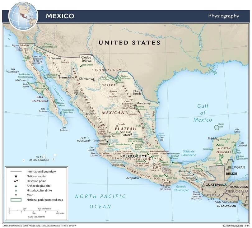
Physiographic map of Mexico.
Climate Patterns
The complex interplay of latitude, elevation, and proximity to large bodies of water shapes Mexico's climate. The country experiences virtually every climate type found between Canada and the equator, from desert conditions in the northwest to tropical rainforest in the southeast.
Temperature patterns are largely controlled by elevation rather than latitude. Coastal areas and low-lying regions maintain warm temperatures year-round, with average temperatures ranging from 24°C to 28°C (75°F to 82°F). The Mesa Central enjoys a temperate climate, with average temperatures ranging between 16°C and 20°C (61°F to 68°F). In contrast, high mountain areas experience cool conditions, with temperatures dropping below freezing at elevations above 3,000 meters (9,843 feet).
Precipitation patterns show dramatic regional variation, influenced by topography, prevailing winds, and seasonal weather systems. The Gulf of Mexico coastal regions receive the highest rainfall, with some areas exceeding 2,000 millimeters (79 inches) annually. The windward slopes of mountains also receive heavy precipitation, particularly during the summer monsoon season from June through September.
In contrast, much of northern Mexico receives less than 300 millimeters (12 inches) of annual precipitation, creating desert and semi-desert conditions. The Sonoran Desert in northwestern Mexico ranks among North America's most arid regions, with some areas receiving less than 100 millimeters (4 inches) annually.
The Yucatan Peninsula experiences a tropical climate with distinct wet and dry seasons. The region receives 1,000 to 1,500 millimeters (39 to 59 inches) of rainfall annually, concentrated primarily between May and October. This precipitation supports tropical forests dominated by species such as Cecropia and Brosimum, along with economically important trees like mahogany (Swietenia macrophylla).
River Systems and Water Resources
Mexico's river systems reflect the country's complex topography and varied precipitation patterns. Most rivers are relatively short due to the proximity of mountain ranges to the coasts, and many northern rivers are intermittent, flowing only during rainy periods.
The Rio Grande (known as Rio Bravo del Norte in Mexico) forms much of the border with the United States, draining portions of the Mesa del Norte before emptying into the Gulf of Mexico. This river system, including its major Mexican tributary, the Rio Conchos, provides crucial water resources for agriculture and urban areas in an otherwise arid region.
The Lerma-Santiago system represents Mexico's longest internal river network, extending approximately 1,180 kilometers (733 miles) from its source in the Valley of Toluca to its mouth at San Blas, Nayarit. This system drains much of the Mesa Central, passing through Lake Chapala, Mexico's largest natural lake, before continuing as the Santiago River to the Pacific Ocean.
Southern Mexico features numerous shorter but more reliable rivers due to its higher precipitation levels. The Grijalva-Usumacinta system drains much of Chiapas and Tabasco, creating extensive wetlands and supporting important hydroelectric projects. The Papaloapan River system, spanning Veracruz and Oaxaca, has been extensively modified for flood control and irrigation purposes.
Water availability remains a critical challenge for Mexico, with the northern regions accounting for 77 percent of the population but only 31 percent of the renewable water resources. This imbalance has necessitated major water transfer projects and the careful management of groundwater resources, particularly in the Mexico City metropolitan area.
Ecological Regions and Biodiversity
Mexico's geographic diversity creates numerous distinct ecological regions, contributing to the country's status as one of the World's most biodiverse nations. The country contains portions of two major biogeographic realms: the Nearctic in the north and the Neotropical in the south, with the Trans-Mexican Volcanic Belt serving as the primary transition zone.
The Sonoran Desert ecosystem spans northwestern Mexico, characterized by distinctive vegetation, including columnar cacti such as Carnegiea gigantea (saguaro) and Pachycereus pringlei (Mexican giant cardon). This desert supports unique fauna, including the desert bighorn sheep (Ovis canadensis) and numerous endemic reptile species.
The Sierra Madre Occidental supports extensive coniferous forests, including important populations of Pinus species and Mexican endemic trees such as Pseudotsuga menziesii var. glauca. These forests provide habitat for large mammals, including the Mexican black bear and the mountain lion (Puma concolor).
Central Mexico's temperate forests are found at elevations between 2,000 and 4,000 meters (6,562 to 13,123 feet), characterized by the dominance of oak (Quercus) and pine (Pinus) species. These ecosystems support high levels of endemism, particularly among plant species adapted to the region's volcanic soils and seasonal climate patterns.
Tropical dry forests extend along much of the Pacific coast, characterized by species that shed their leaves during the dry season. These forests support important populations of jaguars (Panthera onca) and contain numerous endemic plant species, including economically valuable timber trees such as Tabebuia species.
The tropical rainforests of southeastern Mexico represent the northernmost extension of Central American rainforest ecosystems. The Selva Lacandona of Chiapas contains Mexico's largest remaining tract of tropical rainforest, supporting species such as howler monkeys (Alouatta), tapirs (Tapirus bairdii), and over 300 bird species.
Coastal ecosystems include extensive mangrove forests, particularly along the Gulf of Mexico and Caribbean coasts. These systems, dominated by Rhizophora mangle, Avicennia germinans, and Laguncularia racemosa, provide critical habitat for numerous fish species and serve as nurseries for commercially important marine life.
Geological History and Mineral Resources
Mexico's complex geology reflects a history of tectonic activity, volcanic processes, and varied depositional environments. The country sits at the intersection of several tectonic plates, including the North American, Pacific, and Caribbean plates, resulting in ongoing seismic activity and volcanic processes.
The Sierra Madre Oriental consists primarily of folded limestone and shale formations dating back to the Mesozoic Era, while the Sierra Madre Occidental is composed largely of volcanic rocks from eruptions of the Tertiary period. The Trans-Mexican Volcanic Belt represents the most recent phase of volcanic activity, with some volcanoes remaining active to this day.
This geological diversity has endowed Mexico with substantial mineral wealth. The country ranks among the World's leading silver producers, with major deposits in states such as Zacatecas, Chihuahua, and Durango. Copper mining is significant in Sonora and other northwestern states, while gold deposits are found throughout the Sierra Madre ranges.
Mexico also possesses important energy resources, including substantial petroleum deposits along the Gulf of Mexico coastal plain and offshore areas. Natural gas resources are found in association with oil deposits and separate formations throughout northern Mexico. Coal deposits in Coahuila support thermal power generation and steel production.
Human Geography and Settlement Patterns
Mexico's physical geography has profoundly influenced human settlement patterns throughout history. The temperate highlands of central Mexico have supported the development of major pre-Columbian civilizations, including the Aztec Empire, which was centered in the Valley of Mexico. These same regions continue to support the highest population densities today.
The Mexico City metropolitan area, situated at an elevation of 2,240 meters (7,349 feet), demonstrates how elevation moderates tropical latitude temperatures, creating favorable conditions for large urban populations. The city's location in an enclosed basin, however, creates challenges including air pollution retention and water supply difficulties.
Coastal regions support important port cities and tourist destinations, while the arid north has developed mining and agricultural centers that are dependent on irrigation systems. The Yucatan Peninsula's flat terrain and limestone geology create unique conditions, including underground river systems and cenotes, that have influenced both the ancient Maya civilization and modern development patterns.
Environmental Challenges and Conservation
Mexico's diverse geography faces numerous environmental challenges related to rapid population growth, urbanization, and economic development. Deforestation affects mountain forest ecosystems, particularly in the Sierra Madre ranges, where illegal logging poses a significant threat to old-growth forests. The country loses an estimated 500,000 hectares (1.2 million acres) of forest annually.
Water scarcity affects much of northern Mexico, exacerbated by climate change and increasing demands from urban and agricultural users. The Mexico City metropolitan area faces particular challenges due to its elevation and location in an enclosed basin, requiring water pumping from distant sources at enormous energy costs.
Air pollution affects major urban areas, particularly Mexico City, where topographic conditions trap pollutants in the valley atmosphere. The city's elevation also affects combustion efficiency and the formation of pollution, creating unique challenges for managing air quality.
Coastal ecosystems face pressures from tourism development, urbanization, and the impacts of climate change, including sea level rise and increased hurricane intensity. Mangrove forests and coral reefs are particularly vulnerable to these combined pressures.
Conservation efforts encompass an extensive system of protected areas that cover approximately 13 percent of the national territory. Major reserves such as the Calakmul Biosphere Reserve in Campeche protect important tropical forest ecosystems, while marine protected areas safeguard coastal and marine environments.
Conclusion
Mexico's geography represents one of nature's most remarkable demonstrations of diversity within a single nation's borders. From the towering volcanic peaks of the Trans-Mexican Volcanic Belt to the pristine beaches of the Caribbean coast, from the ancient deserts of the north to the lush rainforests of the south, Mexico encompasses an extraordinary range of landscapes, climates, and ecosystems.
This geographic diversity has shaped Mexican civilization from pre-Columbian times to the present, influencing settlement patterns, economic activities, and cultural development. The country's position at the intersection of North and Central America, combined with its complex topography and diverse climate zones, has created conditions that support exceptional biological diversity and natural resource wealth.
Understanding Mexico's geography is crucial for appreciating both its natural heritage and the challenges it faces as a dynamic nation. As Mexico continues to develop economically while confronting environmental pressures, the sustainable management of its diverse geographic resources becomes increasingly important. The country's geographic wealth represents both tremendous opportunities and significant responsibilities for current and future generations.
The mountains, valleys, deserts, and forests of Mexico tell a story of geological forces, climatic patterns, and ecological processes that have been at work for millions of years. Today, these same landscapes support over 130 million people and provide resources essential for national development. Mexico's geographic legacy thus represents not merely a collection of physical features, but the foundation upon which the nation's past, present, and future continue to unfold.