The Caribbean's Aquatic Tapestry: Exploring the Region's Diverse Water Bodies
The Caribbean is a complex and diverse aquatic ecosystem, with waters ranging from turquoise beaches to freshwater lakes within volcanic craters. Its interconnected water bodies shape the region's geography, ecology, and human civilization, playing a vital role in its environment and economy.
 view from Los Angeles, USA, CC BY 2.0, via Wikimedia Commons")
Caribbean Waters: A Geographic Survey of Seas, Rivers, and Lakes
The Caribbean region, spanning approximately 2.7 million square kilometers (1.04 million square miles) of the western Atlantic Ocean, is one of the world's most complex and diverse aquatic ecosystems. From the turquoise waters that lap against pristine beaches to the hidden freshwater lakes nestled within volcanic craters, the Caribbean's water bodies form an intricate network that has shaped the region's geography, ecology, and human civilization for thousands of years. These aquatic systems encompass everything from vast oceanic passages that connect major bodies of water to intimate lagoons that serve as nurseries for countless marine species, each playing a crucial role in the region's environmental and economic vitality.
The Caribbean Sea: Foundation of Regional Waters
The Caribbean Sea itself forms the centerpiece of the region's aquatic landscape, covering approximately 2.75 million square kilometers (1.06 million square miles) and reaching maximum depths of over 7,686 meters (25,217 feet) in the Cayman Trough. The Greater Antilles define the sea's boundaries to the north, the Lesser Antilles to the east, and the continental coastlines of Central and South America to the west and south. The Caribbean Sea's warm, tropical waters, maintained at temperatures between 24 °C and 28°C (75°F and 82°F) year-round, create ideal conditions for coral reef development and support an extraordinary diversity of marine life.
The sea's circulation patterns are dominated by the Caribbean Current, which flows westward through the region before contributing to the Gulf Stream system. These currents transport warm water and nutrients throughout the basin, influencing weather patterns across the wider Atlantic region and supporting the complex food webs that characterize Caribbean marine ecosystems.
Major Straits and Passages
Strategic Maritime Corridors
The Caribbean's strategic location has made its straits and passages crucial for international maritime commerce and naval operations. The Windward Passage, separating Cuba from Haiti, spans approximately 80 kilometers (50 miles) at its narrowest point and serves as one of the primary routes connecting the Atlantic and Pacific oceans via the Panama Canal. This deep-water passage, reaching depths of over 1,700 meters (5,577 feet), accommodates the largest commercial vessels and represents one of the world's busiest shipping lanes.
The Mona Passage, stretching 130 kilometers (81 miles) between Puerto Rico and the Dominican Republic, creates another vital shipping corridor while also serving as a major migration route for humpback whales. The passage's maximum depth of approximately 1,000 meters (3,281 feet) and its strategic position make it essential for both commercial navigation and marine wildlife conservation efforts.
Inter-Island Connections
Smaller passages between Caribbean islands create important ecological and navigational links throughout the archipelago. The Guadeloupe Passage separates the islands of Guadeloupe and Dominica, while the Martinique Passage lies between Dominica and Martinique. These passages, typically ranging from 30 to 50 kilometers (19 to 31 miles) in width, facilitate water exchange between the Atlantic Ocean and the Caribbean Sea, supporting nutrient flow and marine biodiversity.
The Anegada Passage, located between the British Virgin Islands and the Lesser Antilles, represents the deepest water connection between the Atlantic and the Caribbean, with depths exceeding 2,000 meters (6,562 feet). This passage plays a crucial role in deep-water circulation patterns and serves as a migration corridor for deep-sea species.
Gulfs and Bays
Major Gulf Systems
The Gulf of Venezuela, also known as the Gulf of Coquivacoa, forms the largest gulf in the Caribbean region, covering approximately 13,500 square kilometers (5,212 square miles). Located between the Guajira Peninsula of Colombia and the Paraguaná Peninsula of Venezuela, the gulf reaches maximum depths of 250 meters (820 feet). It connects to Lake Maracaibo through the narrow Tablazo Strait. The gulf's shallow waters and restricted circulation create unique ecological conditions that support specialized marine communities.
The Gulf of Urabá, located along Colombia's Caribbean coast, spans approximately 3,000 square kilometers (1,158 square miles) and receives freshwater input from several major rivers, including the Atrato River. The gulf's brackish conditions create extensive mangrove systems that serve as crucial nursery habitats for numerous fish species and support important shrimp fisheries.
Significant Bay Systems
Throughout the Caribbean, numerous bays provide protected harbors and unique ecological niches. Montego Bay, in Jamaica, spans approximately 15 square kilometers (5.8 square miles) and combines tourism importance with significant marine ecosystems, including coral reefs and seagrass beds. The bay's relatively shallow waters, averaging 20-30 meters (66-98 feet) in depth, support diverse fish populations and serve as important feeding grounds for sea turtles.
Carlisle Bay in Barbados spans approximately 8 square kilometers (3.1 square miles) and boasts a distinctive blend of coral reefs, sandy bottoms, and several shipwrecks that have been converted into artificial reefs. The bay's protected waters and diverse habitats make it a popular destination for marine recreation and scientific research.
Rivers and Freshwater Systems
Major River Systems
The Caribbean region's rivers, although generally shorter than those found on larger continental landmasses, play vital roles in freshwater supply, sediment transport, and the health of coastal ecosystems. The Cauto River in Cuba, stretching approximately 370 kilometers (230 miles), represents the longest river in the Caribbean islands. Flowing through the Cauto Valley before reaching the Gulf of Guacanayabo, the river drains an area of roughly 9,000 square kilometers (3,475 square miles) and supports extensive agricultural activities.
In Puerto Rico, the Río Grande de Loíza extends for 65 kilometers (40 miles) and drains approximately 1,300 square kilometers (502 square miles) of the island's northern region. The river's watershed encompasses a diverse range of ecosystems, from mountain forests to coastal wetlands, and provides crucial freshwater resources for the metropolitan area of San Juan.
The Ozama River in the Dominican Republic, flowing for approximately 148 kilometers (92 miles), passes through the capital city of Santo Domingo before reaching the Caribbean Sea. The river's lower reaches have undergone significant modifications for urban development and port facilities, while its upper watershed remains crucial for freshwater supply and flood control.
Mainland Coastal Rivers
Along the Caribbean coasts of Central and South America, numerous rivers discharge freshwater and sediments into the sea, creating important estuarine environments. The Magdalena River in Colombia, while primarily flowing northward to the Caribbean coast, forms a significant delta system that covers approximately 4,000 square kilometers (1,544 square miles). The river's annual discharge of roughly 7,000 cubic meters per second (247,000 cubic feet per second) delivers essential nutrients to coastal waters while creating extensive wetland habitats.
The Orinoco River, though primarily associated with Venezuela's Atlantic coast, influences Caribbean waters through its massive discharge and sediment plume. The river's delta region, spanning over 25,000 square kilometers (9,653 square miles), is one of the largest river deltas in South America and supports an extraordinary biodiversity.
Lakes and Lagoons
Volcanic and Crater Lakes
The Caribbean's volcanic origins have created numerous crater lakes that serve as unique freshwater ecosystems. Lake Enriquillo, located in the Dominican Republic, spans approximately 375 square kilometers (145 square miles) and represents the largest lake in the Caribbean, as well as one of the few saltwater lakes in the region. Located 46 meters (151 feet) below sea level, the lake supports populations of American crocodiles and various bird species despite its hypersaline conditions.
Lago de Coatepeque in El Salvador, although technically outside the Caribbean Sea proper, has a significant influence on regional freshwater systems. The volcanic crater lake covers 25 square kilometers (9.7 square miles) and reaches depths of 115 meters (377 feet), making it one of the deepest lakes in Central America.
Coastal Lagoons
Coastal lagoons throughout the Caribbean provide crucial habitat for juvenile fish, shellfish, and numerous bird species. The Laguna Grande in Puerto Rico covers approximately 1.2 square kilometers (0.46 square miles) and features one of the world's few bioluminescent bays, where microscopic dinoflagellates create natural light displays. The lagoon's mangrove-lined shores and unique biochemical properties make it a significant ecological and tourist attraction.
The Laguna de Tacarigua in Venezuela spans approximately 190 square kilometers (73 square miles) and is one of the largest coastal lagoons in the Caribbean region. Separated from the Caribbean Sea by barrier islands, the lagoon supports extensive mangrove forests and serves as a critical habitat for flamingos, herons, and other waterbirds.
Unique Aquatic Features
Cenotes and Underground Waters
The Yucatan Peninsula's Caribbean coast is home to numerous cenotes—natural sinkholes filled with freshwater that connect to extensive underground river systems. These formations, numbering in the thousands, provide unique diving experiences and serve as important freshwater sources for local communities. The cenote systems extend for hundreds of kilometers underground, creating some of the world's longest underwater cave networks.
Bioluminescent Waters
Several Caribbean locations feature bioluminescent waters created by microscopic organisms. Beyond Puerto Rico's Laguna Grande, Holbox Island in Mexico, and the Luminous Lagoon in Jamaica, these locations showcase this rare phenomenon. These waters glow blue-green when disturbed, creating spectacular natural light shows that attract researchers and tourists from around the world.
Environmental Significance and Conservation
The Caribbean's water bodies face numerous environmental challenges, including pollution, overfishing, climate change, and coastal development. Rising sea temperatures threaten coral reef systems, while increased hurricane intensity affects coastal lagoons and mangrove forests. Ocean acidification, caused by increased atmospheric carbon dioxide, poses additional threats to shell-forming organisms and coral reefs.
Conservation efforts throughout the region focus on establishing marine protected areas, reducing pollution inputs, and promoting sustainable fishing practices. The Caribbean Sea has been designated as a Large Marine Ecosystem, recognizing its ecological significance and the need for coordinated conservation efforts that span national boundaries.
Economic and Cultural Importance
Caribbean water bodies support a diverse range of economic activities, including tourism, fishing, shipping, and port operations. The region's harbors and bays serve as crucial stops for cruise ships and cargo vessels, while pristine beaches and coral reefs attract millions of visitors annually. Fishing industries rely on healthy marine ecosystems, while emerging aquaculture operations aim to supplement wild-caught seafood.
Cultural connections to water bodies run deep throughout Caribbean societies. Rivers provide freshwater for agriculture and domestic use, while coastal waters support traditional fishing communities. Many Caribbean cultures incorporate water symbolism into their art, music, and spiritual practices, reflecting the fundamental importance of aquatic systems to island life.
Summary
The Caribbean region's water bodies represent a remarkable diversity of aquatic ecosystems, from the vast Caribbean Sea to intimate crater lakes, from bustling shipping passages to pristine bioluminescent lagoons. These waters support extraordinary biodiversity, facilitate international commerce, provide essential resources for local communities, and give rise to some of the world's most spectacular natural phenomena. The major straits and passages serve as crucial links between ocean basins, facilitating marine migration, while gulfs and bays provide protected environments for both human activities and wildlife. Rivers, although generally shorter than those on larger landmasses, play vital roles in freshwater supply and the health of coastal ecosystems. Lakes and lagoons, whether freshwater or saline, volcanic or coastal, contribute unique ecological niches that support specialized communities of organisms. The region's water bodies face significant environmental challenges that require coordinated conservation efforts, but their continued health remains essential for the ecological, economic, and cultural well-being of Caribbean nations and the broader global community.
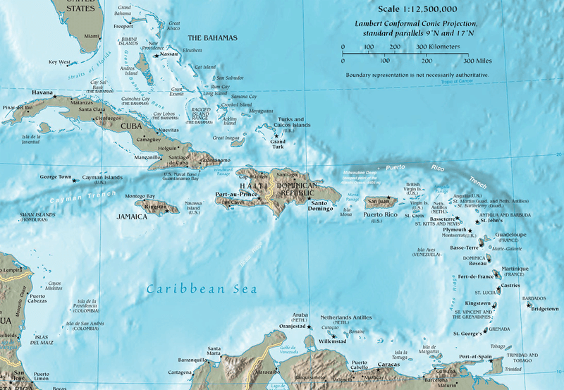
Map of the Caribbean region with topographical features.
Notable Water Bodies of the Caribbean Region
Seas and Major Water Bodies
- Caribbean Sea: 2.75 million km² (1.06 million mi²) - Western Atlantic Ocean
- Gulf of Mexico: 1.6 million km² (0.62 million mi²) - Northern Caribbean boundary
Major Straits and Passages
- Windward Passage: 80 km (50 mi) wide - Between Cuba and Haiti
- Mona Passage: 130 km (81 mi) wide - Between Puerto Rico and the Dominican Republic
- Yucatan Channel: 217 km (135 mi) wide - Between Mexico and Cuba
- Anegada Passage: 40 km (25 mi) wide - Between British Virgin Islands and Lesser Antilles
- Guadeloupe Passage: 50 km (31 mi) wide - Between Guadeloupe and Dominica
- Martinique Passage: 30 km (19 mi) wide - Between Dominica and Martinique
- St. Lucia Channel: 32 km (20 mi) wide - Between Martinique and St. Lucia
- St. Vincent Passage: 35 km (22 mi) wide - Between St. Lucia and St. Vincent
- Grenada Passage: 130 km (81 mi) wide - Between Grenada and Trinidad
Gulfs and Bays
- Gulf of Venezuela: 13,500 km² (5,212 mi²) - Northwestern Venezuela
- Gulf of Urabá: 3,000 km² (1,158 mi²) - Northwestern Colombia
- Gulf of Paria: 7,800 km² (3,012 mi²) - Between Venezuela and Trinidad
- Gulf of Guacanayabo: 2,200 km² (849 mi²) - Southern Cuba
- Montego Bay: 15 km² (5.8 mi²) - Northwestern Jamaica
- Kingston Harbor: 22 km² (8.5 mi²) - Southeastern Jamaica
- Carlisle Bay: 8 km² (3.1 mi²) - Southwestern Barbados
- Bridgetown Harbor: 4 km² (1.5 mi²) - Southwestern Barbados
- San Juan Bay: 8.5 km² (3.3 mi²) - Northern Puerto Rico
- Cienfuegos Bay: 88 km² (34 mi²) - Southern Cuba
- Santiago Bay: 12 km² (4.6 mi²) - Southeastern Cuba
Major Rivers
- Cauto River: 370 km (230 mi) - Cuba (the longest Caribbean island river)
- Magdalena River: 1,540 km (957 mi) - Colombia (Caribbean-draining portion)
- Atrato River: 750 km (466 mi) - Colombia
- Coco River: 680 km (422 mi) - Nicaragua/Honduras border
- Patuca River: 500 km (311 mi) - Honduras
- Ulúa River: 358 km (222 mi) - Honduras
- Ozama River: 148 km (92 mi) - Dominican Republic
- Yaque del Norte River: 296 km (184 mi) - Dominican Republic
- Artibonite River: 321 km (199 mi) - Haiti
- Río Grande de Loíza: 65 km (40 mi) - Puerto Rico
- Río Grande de Arecibo: 60 km (37 mi) - Puerto Rico
Lakes
- Lake Enriquillo: 375 km² (145 mi²) - Dominican Republic (largest Caribbean lake)
- Laguna de Tacarigua: 190 km² (73 mi²) - Venezuela
- Lake Izabal: 589 km² (227 mi²) - Guatemala
- Lake Managua: 1,042 km² (402 mi²) - Nicaragua
- Lake Nicaragua: 8,264 km² (3,191 mi²) - Nicaragua
- Laguna Grande: 1.2 km² (0.46 mi²) - Puerto Rico (bioluminescent)
- Laguna de Oviedo: 28 km² (11 mi²) - Dominican Republic
- Sian Ka'an Lagoon: 75 km² (29 mi²) - Mexico
- Laguna de Términos: 2,500 km² (965 mi²) - Mexico
Significant Lagoons and Coastal Water Bodies
- Ciénaga Grande de Santa Marta: 4,280 km² (1,653 mi²) - Colombia
- Los Olivitos Lagoon: 250 km² (97 mi²) - Venezuela
- Laguna de Unare: 40 km² (15 mi²) - Venezuela
- Laguna de Píritu: 18 km² (7 mi²) - Venezuela
- Mosquito Lagoon: 135 km² (52 mi²) - Puerto Rico
- Laguna San José: 45 km² (17 mi²) - Puerto Rico
- Laguna Tortuguero: 25 km² (9.7 mi²) - Puerto Rico
Underground and Cenote Systems
- Riviera Maya Cenote System: 1,000+ individual cenotes - Mexico
- Sac Actun System: 347 km (216 mi) mapped - Mexico (world's longest underwater cave)
- Ox Bel Ha System: 271 km (168 mi) mapped - Mexico
- Dos Ojos System: 82 km (51 mi) mapped - Mexico