The Geography of Suriname: Nature's Pristine Laboratory in South America
Suriname is the smallest country in South America, yet it holds significant geographical importance. Situated on the northeastern coast of the continent, its strategic location at the crossroads of Caribbean and South American biogeographic zones enhances its rich ecological diversity and culture.

 https://www.flickr.com/photos/speakingoffaith/5726984481")


 https://www.flickr.com/photos/delphinidaesy/6863290621")
, https://www.flickr.com/photos/-jvl-/33408890481/in/album-72157714724476982/")
From Coastal Mangroves to Pristine Rainforests: The Physical Geography of Suriname
Suriname, officially known as the Republic of Suriname, stands as South America's smallest independent nation, yet its geographic significance far exceeds its modest dimensions. With a land area of 163,000 square kilometers (63,000 square miles), this former Dutch colony presents one of the most pristine and biodiverse landscapes on Earth. Approximately 93% of the country remains covered in natural tropical rainforests, making it a living laboratory for understanding neotropical ecosystems and their complex interactions.
Positioned on the northeastern coast of South America, Suriname is bordered by the Atlantic Ocean to the north, French Guiana to the east, Brazil to the south, and Guyana to the west. This strategic location places the nation at the intersection of Caribbean and South American biogeographic regions, contributing to its remarkable ecological diversity and unique cultural landscape.
Physical Geography and Topography
Suriname's physical geography can be understood through distinct regional divisions that reflect both geological history and contemporary environmental conditions. The country is situated on the Guiana Shield, one of the three cratons of the South American Plate, providing the geological foundation for its diverse topographic features.
Coastal Plains and Lowlands
The northern coastal region represents Suriname's most densely populated area, characterized by extensive lowlands that rarely exceed 50 meters (164 feet) above sea level. The country's 354-kilometer (220-mile) shoreline along the Atlantic Ocean consists predominantly of mud flats and mangrove swamps. These coastal wetlands serve as critical nursery habitats for marine species, providing natural protection against storm surges and coastal erosion.
The coastal plain extends approximately 80 kilometers (50 miles) inland and encompasses the fertile polders that support Suriname's agricultural sector. These artificially drained and cultivated areas were created through Dutch engineering expertise during the colonial period, transforming natural swamplands into productive agricultural zones. The coastal sediments, primarily composed of fine clays and silts deposited by major rivers, create some of South America's most fertile soils.
Interior Highlands and Mountain Ranges
The natural landscape transitions into two main mountain ranges: the Bakhuis and Van Asch Van Wijck Mountains. Julianatop stands as the highest mountain in the country, at 1,286 meters (4,219 feet) above sea level, located within the Wilhelmina Mountains, which form part of the larger Tumuc-Humac range that extends into Brazil.
The Bakhuis Mountains, located in the western part of the country, rise to elevations of approximately 1,200 meters (3,937 feet) and contain significant bauxite deposits that form the backbone of Suriname's mining industry. These ancient formations, composed primarily of Precambrian rocks that date back over 1.7 billion years, provide valuable insights into Earth's early geological history.
The Van Asch Van Wijck Mountains occupy the central-eastern region and feature dramatic tepuis (table mountains) similar to those found in Venezuela's Roraima region. These isolated mountain tops support unique endemic flora and fauna that evolved in isolation, creating biological islands within the larger rainforest matrix.
River Systems and Hydrology
Suriname's hydrological network plays a fundamental role in shaping both its physical geography and human settlement patterns. The country's rivers flow northward from the interior highlands toward the Atlantic Ocean, creating a dendritic drainage pattern that has influenced transportation routes, settlement locations, and ecological connectivity for millennia.
The Suriname River, from which the country derives its name, serves as the most significant waterway, flowing approximately 480 kilometers (298 miles) from its headwaters in the Wilhelmina Mountains to its mouth near Paramaribo. The middle section of the river features the Brokopondo Reservoir, created by the construction of the Afobaka Dam in 1964, which provides hydroelectric power and spans an area of approximately 1,560 square kilometers (602 square miles).
The Maroni River (Marowijne) forms the natural border with French Guiana and represents one of South America's most pristine river systems. Flowing for over 600 kilometers (373 miles), this river maintains largely undisturbed riparian forests and supports diverse aquatic ecosystems. The Corantijn River marks the western boundary with Guyana and provides similar ecological services, supporting traditional Indigenous and Maroon communities.
Other significant waterways include the Coppename River, which flows through the heart of the Central Suriname Nature Reserve, and the Saramacca River, which drains the western coastal region. These rivers collectively transport enormous quantities of sediment to the coast, contributing to the dynamic nature of Suriname's coastal geography.
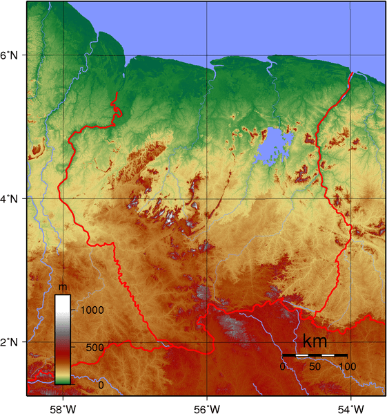
Topographical map of Suriname.
Climate and Weather Patterns
Suriname experiences a tropical climate characterized by high temperatures, abundant rainfall, and minimal seasonal temperature variation. The country's position just north of the equator, combined with its coastal location and extensive forest cover, creates a complex climatological system influenced by both Atlantic maritime conditions and the dynamics of continental rainforests.
Temperature Regimes
Mean annual temperatures throughout Suriname range from 26°C to 28°C (79°F to 82°F), with minimal variation between seasons. Coastal areas experience slightly more moderate temperatures due to maritime influences, while interior regions may experience marginally higher maximum temperatures. Diurnal temperature variation typically ranges from 6°C to 8°C (11°F to 14°F), providing some relief from daytime heat.
The country's thermal regime reflects its equatorial location, where solar radiation remains relatively constant throughout the year. Cloud cover from frequent precipitation and extensive evapotranspiration from forest canopies helps moderate temperature extremes, preventing the intense heat experienced in other tropical regions with less forest cover.
Precipitation Patterns
Suriname receives abundant precipitation throughout the year, with annual totals ranging from 1,500 millimeters (59 inches) in coastal areas to over 3,000 millimeters (118 inches) in interior mountainous regions. The precipitation regime follows a complex pattern influenced by the Intertropical Convergence Zone (ITCZ), northeast trade winds, and local topographic effects.
Two distinct rainy seasons characterize Suriname's precipitation patterns: a major rainy season from April to August and a minor rainy season from December to February. These wet periods are separated by relatively drier intervals, though "dry" remains a relative term in this humid tropical environment. Even during the driest months, monthly precipitation typically exceeds 100 millimeters (4 inches) per month.
The interior mountains experience orographic precipitation enhancement, where air masses are forced upward along mountain slopes, resulting in cooling and increased rainfall. This effect creates localized climate zones within mountain valleys, contributing to the exceptional biodiversity found in these regions.
Humidity and Wind Patterns
Relative humidity remains consistently high throughout Suriname, typically ranging from 75% to 85% on an annual basis. The extensive forest cover and numerous water bodies contribute to high atmospheric moisture content through evapotranspiration processes. During rainy seasons, humidity levels can reach up to 90%, creating challenging conditions for human activities but supporting the lush tropical vegetation.
Northeast trade winds dominate Suriname's wind patterns, bringing moisture-laden air from the Atlantic Ocean. These winds moderate coastal temperatures and contribute to precipitation patterns, particularly during the major rainy season. Interior regions experience more variable wind patterns, influenced by local topography and the effects of the forest canopy.
Biodiversity and Natural Resources
Suriname's geographic position and environmental conditions have created one of Earth's most biodiverse nations per unit area. Within its borders, Suriname boasts approximately 696 bird species, 114 amphibian species, 1,046 fish species, 207 mammal species, 156 reptile species, and around 5,100 species of vascular plants, many of which remain scientifically undescribed.
Flora Diversity
Approximately nine-tenths of Suriname's area is covered with heterogeneous forest, comprising more than 1,000 species of trees. The botanical diversity reflects the country's position at the intersection of Amazonian and Guianan floristic provinces, creating unique assemblages of plant communities adapted to various ecological niches.
The coastal region supports distinctive mangrove ecosystems dominated by species such as Rhizophora mangle (Red Mangrove), Avicennia germinans (Black Mangrove), and Laguncularia racemosa (White Mangrove). These halophytic plants have evolved specialized adaptations for saltwater environments, including pneumatophores for oxygen exchange and salt-secreting leaves.
Interior rainforests showcase remarkable tree diversity, with emergent species reaching heights of 50-60 meters (164-197 feet). The baboen (Virola surinamensis), which grows in the coastal areas, represents one of many economically important timber species. Other significant forest trees include Cecropia species (Trumpet Trees), Swietenia macrophylla (Big-leaf Mahogany), and various Lecythis species (Brazil Nut family).
Epiphytic plants create vertical gardens within the forest canopy, featuring numerous orchid, bromeliad, and fern species that are adapted to this lifestyle. These aerial plants make significant contributions to forest biodiversity and play crucial roles in nutrient cycling and water retention within forest ecosystems.
Fauna Diversity
Suriname's animal life reflects the country's position within the Guianan biogeographic region, hosting numerous endemic species and serving as habitat for wide-ranging neotropical fauna. Protected mammals include the giant anteater, red-faced spider monkey, ocelot, jaguar, bush dog, and the Guiana dolphin.
Large mammals play crucial ecological roles as seed dispersers and predators. The jaguar (Panthera onca) serves as the apex predator, regulating prey populations and maintaining ecosystem balance. The country is home to many unique species of animals, including sloths, anteaters, and several small primates, such as the Guianan Squirrel Monkey.
Bird diversity encompasses species from multiple biogeographic regions, including Amazonian, Guianan, and Caribbean elements. Notable species include the Harpy Eagle (Harpia harpyja), Guianan Cock-of-the-rock (Rupicola rupicola), and numerous tanager, flycatcher, and antbird species. Waterbirds thriving in coastal environments include the Scarlet Ibis (Eudocimus ruber) and various heron and egret species.
Reptile and amphibian diversity reflects the humid tropical conditions, with numerous poison dart frogs (Dendrobates and Phyllobates species), tree frogs, and ground-dwelling species. Snake diversity includes both venomous species, such as the fer-de-lance (Bothrops atrox), and large constrictors like the Green Anaconda (Eunectes murinus).
A large number of unusual bat species are present, representing crucial components of forest ecosystems as pollinators, seed dispersers, and insect predators. The diversity of chiropteran species reflects the variety of available ecological niches within Suriname's complex forest environments.
Aquatic Biodiversity
Suriname's freshwater systems support exceptional fish diversity, with species ranging from tiny tetras to large catfish. The country's rivers contain numerous endemic species adapted to specific water chemistry and flow conditions. Coastal and estuarine environments support both freshwater and marine species, creating unique brackish water communities.
Marine biodiversity along Suriname's coast includes sea turtles, with several species using beaches for nesting. The Leatherback Turtle (Dermochelys coriacea) is the largest marine turtle species and faces conservation challenges due to the impacts of coastal development and climate change.
Protected Areas and Conservation
Suriname has established an impressive network of protected areas covering approximately 12.6% of the national territory. The Central Suriname Nature Reserve, designated as a UNESCO World Heritage Site, encompasses 1.6 million hectares (3.95 million acres) and represents one of the world's largest protected tropical rainforest areas.
The reserve has recorded 680 species of birds, 200 mammals, 152 reptiles, 95 amphibians, and 790 fish species. Although much of the reserve remains unexplored, this suggests that the true extent of its biodiversity may be even greater.
Other significant protected areas include the Brownsberg Nature Park, which protects montane forests and provides opportunities for ecotourism, and the Galibi Nature Reserve, which protects crucial sea turtle nesting beaches along the coast.
Human Geography and Settlement Patterns
Most Surinamers live in the coastal region, where approximately 90% of the population resides within 50 kilometers (31 miles) of the Atlantic Ocean. The capital, Paramaribo, along with other cities including Wageningen, Nieuw Amsterdam, Nieuw Nickerie, and Albina, represent the primary urban centers.
The interior regions remain sparsely populated, primarily inhabited by Indigenous peoples, including the Trio, Wayana, and Akurio groups, as well as Maroon communities descended from escaped enslaved Africans. These populations maintain traditional lifestyles closely integrated with forest ecosystems, possessing extensive traditional ecological knowledge crucial for conservation efforts.
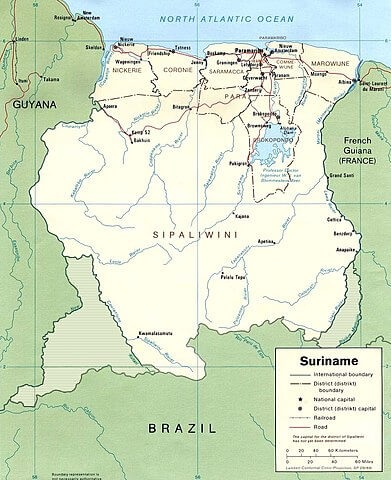
Map of Suriname illustrating disputed border territories.
Border Disputes and Territorial Issues
Suriname is involved in territorial disputes with both Guyana and French Guiana that are legacies of colonial rule. Parts of Suriname's boundaries with French Guiana and Guyana remain in dispute. These unresolved territorial issues reflect the complex colonial history of the Guianas and continue to influence regional relationships and resource management decisions.
Environmental Challenges and Threats
Despite its pristine appearance, Suriname faces several environmental challenges. The destruction of habitats and the disruption of ecosystems have a significant impact on the survival of flora and fauna in Suriname. Mining activities, particularly those focused on gold and bauxite extraction, have localized environmental impacts, including deforestation, water pollution, and habitat fragmentation.
Climate change poses emerging threats to coastal areas through sea-level rise and changing precipitation patterns. The low-lying coastal plain faces particular vulnerability to saltwater intrusion and increased flooding, which can potentially impact both human settlements and agricultural areas.
Suriname is home to endangered species, including the Atlantic goliath grouper and tapirs, which highlight the conservation challenges facing the country's remarkable biodiversity.
Economic Geography and Natural Resources
Suriname's economy relies heavily on natural resource extraction, particularly bauxite mining, which leverages the country's substantial aluminum ore deposits concentrated in the Bakhuis Mountains. Gold mining, both large-scale and artisanal, is prevalent throughout the interior regions, although environmental regulations are in place to minimize ecological impacts.
The forestry sector utilizes the country's extensive timber resources, though sustainable management practices aim to balance economic needs with conservation objectives. Agricultural activities focus on the fertile coastal plains, where rice cultivation and other crops benefit from the rich alluvial soils deposited by the major river systems.
Conclusion
Suriname's geography represents a remarkable convergence of geological history, climatic conditions, and biological evolution, creating one of Earth's most pristine and biodiverse nations. The country boasts a great diversity of flora and fauna, which, for the most part, are increasingly threatened by new development, highlighting the critical importance of balancing economic growth with environmental conservation.
The nation's geographic characteristics—from its ancient Precambrian geological foundation to its complex river systems and exceptional biodiversity—position Suriname as a crucial component of global conservation efforts. Conservation efforts are essential to mitigate these threats and protect the irreplaceable natural heritage that defines this remarkable South American nation.
Understanding Suriname's geography provides insights not only into the country's natural and human systems but also into the broader challenges facing tropical regions worldwide. As global environmental pressures intensify, Suriname's geographic attributes make it both a refuge for biodiversity and a testing ground for sustainable development practices that could serve as models for other tropical nations.