Ecuador's Towering Landscapes: Where Volcanoes Meet the Sky
Ecuador's compact territory encompasses some of South America's most spectacular and geologically active mountain ranges. These majestic peaks, active volcanoes, and ancient massifs not only define the country's physical character but also create a diverse array of microclimates and ecosystems.

 and Cotopaxi (right), as seen from the Pichincha mountain - by Cayambe at lb.wikipedia, CC BY-SA 3.0, via Wikimedia Commons")


The Avenue of Volcanoes: Ecuador's Spectacular Andean Landscape
Ecuador's compact territory encompasses some of South America's most spectacular and geologically active mountain ranges, creating a vertical world that rises from sea level to over 6,000 meters (19,685 feet) within a remarkably small geographic area. These majestic peaks, active volcanoes, and ancient massifs not only define the country's physical character but also create the diverse microclimates and ecosystems that make Ecuador one of the world's most biodiverse nations per square kilometer. Straddling the equator, Ecuador's position gives its mountains a unique tropical alpine character, where glaciated peaks coexist with cloud forests and páramo grasslands.
The Ecuadorian Andes, forming part of the greater Andean chain, split into two parallel cordilleras that create the famous "Avenue of Volcanoes," a dramatic alignment of snow-capped peaks and active volcanic cones that has captivated explorers and scientists for centuries. From the coastal Cordillera de la Costa to the towering stratovolcanoes of the main Andean ranges, Ecuador's mountains serve as crucial water sources, biodiversity refuges, and cultural landmarks for a nation whose identity is intimately connected to these vertical landscapes.
The Andean System: Ecuador's Volcanic Backbone
The Two Main Cordilleras
Ecuador's Andean geography is characterized by two parallel mountain ranges that run north-south through the country's central region, creating a distinctive inter-Andean valley system that has shaped human settlement patterns for millennia.
Cordillera Occidental (Western Cordillera): The Western Cordillera forms Ecuador's primary volcanic axis, hosting many of the country's most active and prominent volcanoes. This range includes some of Ecuador's highest peaks and most geologically dynamic features. The cordillera extends from the Colombian border southward, gradually decreasing in elevation as it approaches Peru. Its volcanic soils have created fertile agricultural zones, particularly in the northern provinces.
Cordillera Real or Oriental (Eastern Cordillera): The Eastern Cordillera, also known as the Cordillera Real, represents a more ancient geological formation compared to its western counterpart. This range features both volcanic and non-volcanic peaks, with several mountains exceeding 5,000 meters (16,404 feet) in elevation. The cordillera serves as a crucial watershed, feeding rivers that flow eastward into the Amazon basin and westward into the Pacific drainage system.
The Inter-Andean Valley
Between these two cordilleras lies the Inter-Andean Valley, a series of connected highland basins at elevations between 2,000 and 3,000 meters (6,562 and 9,843 feet). This valley system, known locally as the "Callejón Interandino," contains most of Ecuador's major cities, including Quito, the capital, and serves as the country's population and agricultural heartland.
Coastal Ranges: Ecuador's Western Ramparts
Cordillera de la Costa
Ecuador's Pacific coast features a separate mountain system known as the Cordillera de la Costa or Cordillera Costanera. These ranges, while significantly lower than the main Andes, reach elevations of up to 800 meters (2,625 feet) and create important microclimates along the coast. The coastal ranges influence precipitation patterns and support unique dry forest ecosystems.
Cordillera de Toisán
In the southern coastal region, the Cordillera de Toisán extends inland from the Pacific, creating a transition zone between coastal lowlands and the main Andean system. These mountains, though modest in elevation, play a crucial role in regional hydrology and climate patterns.
The Avenue of Volcanoes: Ecuador's Volcanic Heritage
Alexander von Humboldt's Legacy
The famous "Avenue of Volcanoes" (Avenida de los Volcanes) was named by German explorer Alexander von Humboldt during his 1802 expedition to Ecuador. This remarkable alignment of volcanic peaks creates one of the world's most spectacular mountain panoramas, with over 70 volcanic formations visible from various points in the Inter-Andean Valley.
Volcanic Activity and Geological Significance
Ecuador is situated atop one of the world's most active volcanic regions, with numerous volcanoes exhibiting recent or ongoing activity. The country's position along the Pacific Ring of Fire, combined with the subduction of the Nazca Plate beneath the South American Plate, creates intense geological activity. Volcanoes like Reventador, Tungurahua, and Sangay regularly produce eruptions, while others like Cotopaxi pose significant hazards due to their proximity to populated areas.
Unique Geographical Features
Chimborazo: The Closest Point to Space
Chimborazo, Ecuador's highest peak, holds the distinction of being the point on Earth's surface farthest from the planet's center due to the equatorial bulge. At 6,263 meters (20,548 feet), its summit is approximately 2,100 meters (6,890 feet) farther from Earth's center than Mount Everest, making it technically the "highest" mountain on Earth when measured from the planet's core.
Glacial Environments at the Equator
Ecuador's high peaks support several tropical glaciers, representing some of the few remaining equatorial ice formations in the world. These glaciers on Chimborazo, Cotopaxi, Cayambe, and other peaks are rapidly retreating due to climate change, providing valuable data for glaciologists studying the dynamics of tropical ice.
Ecological Significance and Biodiversity
Altitudinal Life Zones
Ecuador's mountains create dramatic altitudinal gradients that support an extraordinary diversity of ecosystems within short distances. From tropical montane cloud forests at mid-elevations to alpine tundra and glacial environments at the highest peaks, these vertical life zones harbor numerous endemic species.
Páramo Ecosystems
The high-altitude páramo grasslands, located between 3,000 and 4,500 meters (9,843 and 14,764 feet), represent one of the world's most unique ecosystems. These tropical alpine environments, characterized by specialized plant communities including giant rosettes and cushion plants, serve as crucial water sources for Ecuador's major cities and agricultural regions.
Cloud Forest Biodiversity
The cloud forests on Ecuador's mountain slopes, particularly on the eastern Andean flanks, support some of the highest biodiversity levels on Earth. These mist-shrouded forests serve as bridges between lowland rainforests and high-altitude ecosystems, creating habitat for numerous endemic species, including many birds, orchids, and other specialized organisms.
Cultural and Historical Significance
Indigenous Heritage
Ecuador's mountains have been home to diverse Indigenous peoples for thousands of years, including the Inca, who established significant settlements in the highland valleys. Today, Indigenous communities such as the Otavalo, Salasaca, and Puruhá continue to maintain traditional relationships with these mountain landscapes, practicing ancient agricultural techniques and preserving cultural connections to specific peaks and sacred sites.
Colonial and Modern History
The mountain valleys provided strategic locations for Spanish colonial cities, with Quito being established in 1534 in a valley surrounded by volcanoes. The mountains have continued to influence Ecuador's development, with the Inter-Andean Valley remaining the country's political and economic center.
Economic Importance
Agriculture and Water Resources
Ecuador's mountain regions support intensive agriculture, particularly in the fertile volcanic soils of the Inter-Andean Valley. The mountains serve as crucial watersheds, capturing moisture from both Pacific and Atlantic weather systems to supply water for agriculture, hydroelectric power generation, and urban consumption.
Mining and Geothermal Potential
The volcanic activity that created Ecuador's mountains has also endowed the country with significant mineral resources and geothermal energy potential. Several large-scale mining projects operate in the Cordillera del Cóndor and other mountain regions, while geothermal energy development is being explored near active volcanic areas.
Tourism and Recreation
Ecuador's mountains attract thousands of visitors annually for mountaineering, trekking, and eco-tourism. Popular destinations include the Quilotoa Loop, Cotopaxi National Park, and various climbing routes on the country's major peaks.
Conservation Challenges and Efforts
Protected Areas
Ecuador has established numerous protected areas within its mountain regions, including Sangay National Park, Cotopaxi National Park, and Cayambe-Coca National Park. These areas preserve critical ecosystems while providing opportunities for research and sustainable tourism.
Climate Change Impacts
Ecuador's mountain ecosystems face significant challenges from climate change, particularly the rapid retreat of tropical glaciers and shifts in precipitation patterns. The country serves as a natural laboratory for studying the impacts of climate change on tropical mountain environments.
Conclusion
Ecuador's mountain ranges represent a remarkable concentration of geological, ecological, and cultural diversity within one of South America's smallest countries. From the towering volcanic cones of the Avenue of Volcanoes to the ancient peaks of the Cordillera Real, these mountains define Ecuador's character as a nation of extraordinary vertical diversity. The ongoing volcanic activity, rapidly changing glacial environments, and unique equatorial alpine ecosystems make Ecuador's mountains among the most scientifically significant and visually spectacular in the world.
As Ecuador faces the challenges of the 21st century, including climate change and increasing development pressure, the conservation and sustainable management of these mountain environments will be crucial for preserving both the country's remarkable natural heritage and the well-being of its people. The mountains that have shaped Ecuador's past continue to influence its future, serving as symbols of the country's resilience and natural splendor in an ever-changing world.
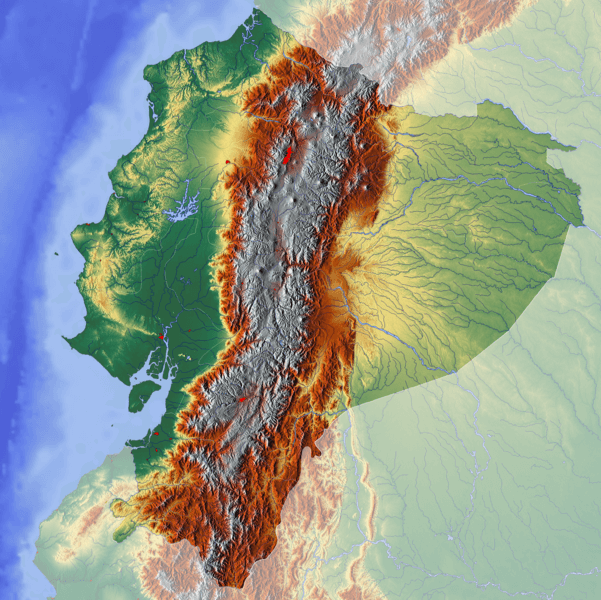
Topographic map of Ecuador.
Major Peaks of Ecuador
Ecuador's Highest Summits
Cordillera Occidental:
- Chimborazo: 6,263 m (20,548 ft) - Ecuador's highest peak
- Cotopaxi: 5,897 m (19,347 ft) - Active volcano
- Cayambe: 5,790 m (18,996 ft) - Northernmost glaciated peak
- Antisana: 5,753 m (18,875 ft)
- Pichincha: 4,784 m (15,696 ft) - Overlooking Quito
- Tungurahua: 5,023 m (16,479 ft) - Active volcano
- Sangay: 5,230 m (17,159 ft) - Highly active volcano
Cordillera Real (Oriental):
- Altar (El Altar): 5,319 m (17,451 ft) - Extinct volcano
- Quilotoa: 3,914 m (12,841 ft) - Crater lake volcano
- Illiniza Norte: 5,126 m (16,817 ft)
- Illiniza Sur: 5,248 m (17,218 ft)
- Sincholagua: 4,893 m (16,053 ft)
Coastal Ranges:
- Cerro de Hayas: 800 m (2,625 ft)
- Cordillera Chongón-Colonche: 800 m (2,625 ft)
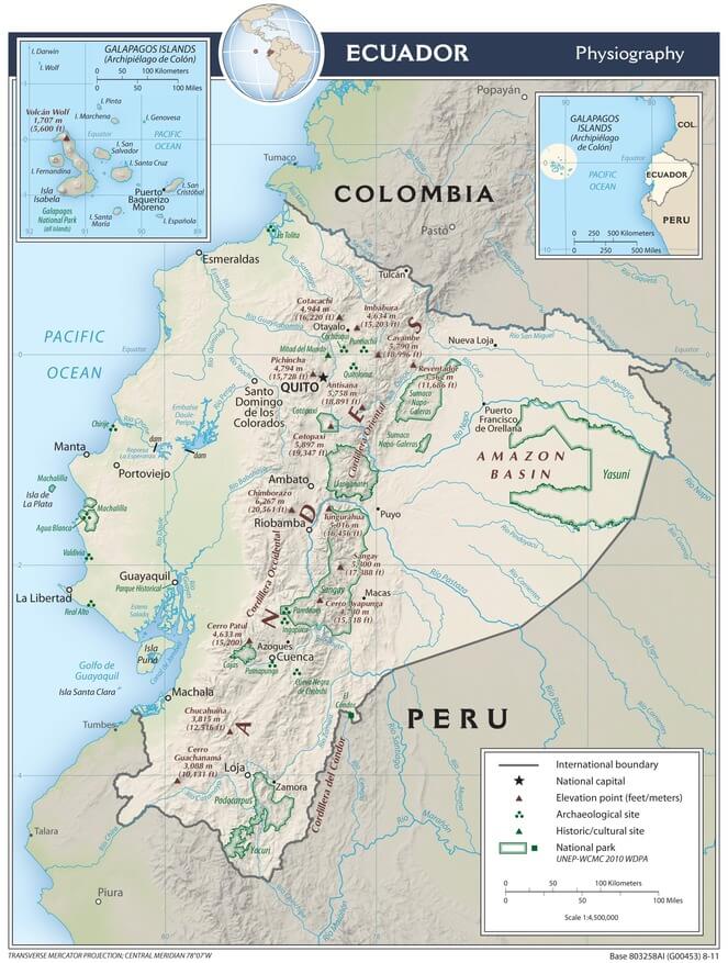
Ecuador physiographic map.