Roatán and the Bay Islands: Caribbean Gems in Honduras' Coral Kingdom
In the Caribbean's azure waters lies one of Central America's most remarkable marine ecosystems—the Bay Islands. Anchored within the Gulf of Honduras, this archipelago stands as a living testament to millions of years of geological evolution and marine biodiversity, with Roatán serving as its crown jewel.

]")
 https://www.flickr.com/photos/funlovers/2720800584")

")

Living Reefs and Island Dreams: Exploring Honduras' Bay Islands Paradise
In the azure waters of the Caribbean Sea, where ancient coral formations meet tropical landscapes, lies one of Central America's most remarkable marine ecosystems—the Bay Islands of Honduras. Anchored within the Gulf of Honduras, this archipelago represents a living testament to millions of years of geological evolution and marine biodiversity, with Roatán serving as its crown jewel. Here, beneath crystalline waters, thrives the second-largest barrier reef system in the world, while above, a rich tapestry of cultures weaves together Indigenous, colonial, and Afro-Caribbean influences. This extraordinary region offers visitors and researchers alike a window into both the Caribbean's natural splendor and its delicate balance between development and conservation.
The Gulf of Honduras: Where Rivers Meet Reefs
The Gulf of Honduras forms a vast marine amphitheater, its waters shaped by the convergence of terrestrial and oceanic forces. This expansive inlet extends across the coasts of Honduras, Guatemala, and Belize, creating a complex ecosystem where twelve major rivers—including the Moho, Sarstún, Río Dulce, Motagua, and Ulúa—pour their nutrient-rich waters into the Caribbean.
This freshwater-saltwater interface has created an extraordinary mosaic of habitats: meandering estuaries where juvenile fish find sanctuary, extensive mangrove forests that serve as natural nurseries, and seagrass beds that support everything from manatees to sea turtles. The northern boundary is marked by Belize's Pelican Cays, part of the magnificent Mesoamerican Barrier Reef System—the second-largest coral reef system in the world, stretching over 900 kilometers along the Caribbean coast.
The complex interplay of ocean currents, tidal movements, and river discharge creates dynamic conditions that support remarkable biodiversity. Barrier beaches protect delicate lagoons, while salt marshes filter runoff and provide critical feeding grounds for migratory birds. Scattered coral cays dot the seascape like emeralds on blue silk, each supporting unique communities of marine life.
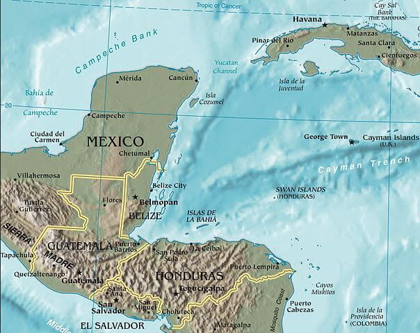
Area map depicting the location of the Gulf of Honduras.
Roatán: An Ancient Reef Transformed
Rising majestically from the Caribbean depths, Roatán tells a story written in limestone and coral. This 77-square-kilometer island rests on the foundation of an ancient coral reef, its highest peaks reaching 270 meters above sea level. The island's mountainous spine creates a dramatic topographical divide, with the Caribbean Trade Winds bringing lush tropical conditions to the northern slopes while creating drier conditions on the southern side.
Geography and Natural Features
Roatán's landscape reflects its coral reef origins. The island's backbone runs east to west, creating valleys and ridges that channel rainwater into numerous creeks and seasonal streams. Along the coastline, living coral reefs extend outward from shore, creating some of the Caribbean's most accessible and spectacular diving sites.
The offshore waters surrounding Roatán are part of the Mesoamerican Barrier Reef System, hosting over 65 species of stony corals and more than 500 species of fish. These reefs serve as both natural breakwaters, protecting the island from storm surge, and as marine highways for everything from colorful parrotfish to massive whale sharks during their seasonal migrations.
Communities and Culture
Roatán's human geography reflects its complex colonial history. The island's largest settlement, Coxen Hole (locally known simply as Roatán), serves as the municipal capital and main commercial hub. This bustling town showcases the island's cultural diversity, where Spanish-speaking mainland Hondurans interact with English-speaking Bay Islanders whose ancestors trace back to British colonial times.
The coastal communities of West End and West Bay have evolved into international destinations, their white-sand beaches and coral reefs attracting visitors from around the globe. Meanwhile, traditional fishing villages like Punta Gorda preserve Garífuna culture, and settlements such as French Harbour maintain their maritime heritage through commercial fishing operations.
Sandy Bay has emerged as an important research and conservation center, home to institutions studying marine ecosystems and coral reef health. Other communities—Gravel Bay, Flowers Bay, Pensacola, Mount Pleasant, Parrot Tree, Jonesville, and Oakridge—each maintain their distinct character while participating in the island's growing eco-tourism economy.
The Bay Islands Archipelago: Three Distinct Groups
The Bay Islands encompass three geographically and ecologically distinct island groups, each with unique characteristics shaped by geology, climate, and human history.
Swan Islands (Islas del Cisne)
The remote Swan Islands form the northernmost group, comprising Great Swan, Little Swan, and Booby Cay. These low-lying coral islands, covering just 3.1 square kilometers, represent one of the Caribbean's most pristine marine environments. Christopher Columbus named them "Islas de las Pozas" (Islands of the Pools) in 1502, referencing their distinctive reef-enclosed lagoons.
Today, the Swan Islands remain largely uninhabited except for a small Honduran naval presence on Great Swan Island. Their isolation has preserved crucial nesting sites for seabirds and marine turtles, while the surrounding waters serve as a marine sanctuary for species ranging from reef sharks to migrating cetaceans.
The Main Islands: Roatán, Guanaja, and Útila
The central Bay Islands group contains the archipelago's largest and most populated islands. Roatán, as described above, serves as the tourism and administrative center. Guanaja, the second-largest island, presents an even more dramatic topographical profile, with peaks reaching over 400 meters. Its mountainous terrain supports cloud forests and endemic species, while its complex coastline creates numerous protected bays and mangrove systems.
Útila offers a different landscape entirely—a low-lying island dominated by mangrove swamps and coastal wetlands, with only a few modest hills breaking the horizon. This topography has made Útila a haven for backpackers and dive enthusiasts, particularly those seeking encounters with whale sharks, which frequently visit the island's waters.
Satellite islands, including Barbareta, Morat, and the Hog Islands, add to the group's diversity. Each supports unique ecosystems, from Barbareta's private resort development to the pristine mangrove systems of the smaller cays.
Cayos Cochinos: A Marine Protected Paradise
The Cayos Cochinos represent conservation success in action. This southern group consists of two main islands—Cayo Grande and Cayo Menor—surrounded by thirteen smaller coral cays. Since 1993, these islands have been protected as the Cayos Cochinos Marine Park, managed by the Honduran Coral Reef Foundation.
The marine park encompasses both terrestrial and marine ecosystems, protecting critical coral reef habitat while supporting sustainable fishing by local Garífuna communities. The islands serve as a natural laboratory for marine research and a model for community-based conservation throughout the Mesoamerican Reef region.
Historical Currents: From Columbus to Conservation
The Bay Islands' human history reflects the broader Caribbean narrative of Indigenous peoples, European colonization, and cultural synthesis. When Columbus first sighted the islands in 1502, they were inhabited by Indigenous peoples who had developed sophisticated maritime cultures adapted to island life.
The arrival of English buccaneers in 1642 marked the beginning of a complex colonial period. For over two centuries, Spain, Honduras, and England contested control of the strategically located islands. This period saw the development of unique cultural communities, including the settlement of freed slaves and the establishment of English-speaking populations that persist today.
The 1852 British annexation, followed by the 1859 cession to Honduras, established the islands' current political status while preserving their distinct cultural identity. This history created the modern Bay Islands' unique blend of Caribbean, Central American, and international influences.
Economic Tides: From Fishing to Sustainable Tourism
The Bay Islands' economy has always been tied to the sea. Traditional fishing communities developed sustainable practices for harvesting lobster, conch, and various reef fish species. Today, approximately 400 commercial boats continue this maritime tradition, though modern challenges include overfishing pressures and climate change impacts on marine ecosystems.
The late 19th century brought brief experiments with banana and pineapple plantations, but the islands' true economic transformation began with the growth of international tourism in the late 20th century. Roatán's designation as a cruise ship destination brought thousands of visitors, while the development of world-class dive operations attracted underwater enthusiasts from around the globe.
Modern economic development increasingly focuses on sustainable tourism models that balance visitor experiences with ecosystem protection. Marine parks, dive operator certification programs, and community-based tourism initiatives represent evolving approaches to economic development that respect both cultural heritage and environmental integrity.
Conservation Challenges and Opportunities
The Bay Islands face the same environmental pressures affecting coral reef systems worldwide: climate change, ocean acidification, pollution, and development pressure. Rising sea temperatures have caused coral bleaching events, while coastal development sometimes conflicts with marine ecosystem protection.
However, the islands also represent hope for marine conservation. Active coral restoration programs, marine protected areas, and research stations contribute to regional conservation efforts. The Mesoamerican Barrier Reef System's designation as a UNESCO World Heritage candidate reflects international recognition of the region's global significance.
Local communities increasingly recognize that their economic future depends on healthy marine ecosystems. This realization drives participation in conservation programs, sustainable fishing practices, and eco-tourism development that showcases rather than degrades natural resources.
Conclusion: Guardians of Caribbean Marine Heritage
The Bay Islands of Honduras represent far more than a tropical vacation destination. They are living laboratories where marine science advances understanding of coral reef ecosystems, cultural crossroads where diverse communities create unique Caribbean societies, and conservation frontiers where sustainable development models are tested and refined.
From Roatán's bustling dive shops to the pristine research stations of Cayos Cochinos, from Útila's whale shark encounters to the bird sanctuaries of the Swan Islands, this archipelago offers profound insights into the challenges and opportunities facing marine ecosystems in the 21st century.
The Gulf of Honduras and its jeweled islands remind us that healthy oceans require active human stewardship. As climate change and development pressures intensify, the Bay Islands' experiences with balancing economic development and environmental protection offer valuable lessons for coastal communities throughout the Caribbean and beyond.
In these waters where ancient coral reefs meet modern conservation science, where traditional fishing communities work alongside international researchers, and where sustainable tourism supports both local livelihoods and ecosystem protection, the Bay Islands continue their evolution as guardians of Caribbean marine heritage.
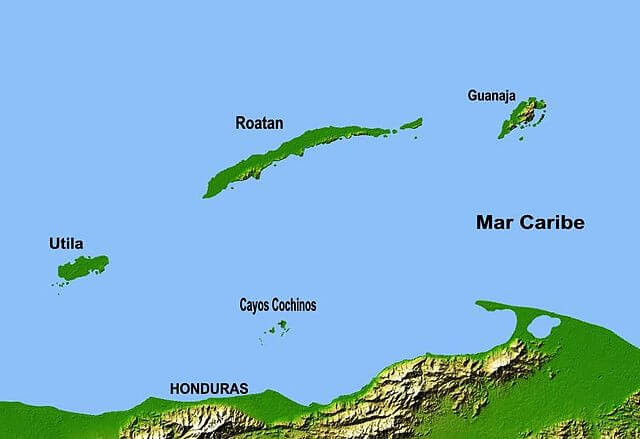
Map depicting the Bay Islands of Honduras.