Mexico's Magnificent Mountain Systems: The Sierra Madre and Beyond
Mexico's dramatic landscape features magnificent mountain systems that rise like ancient sentinels across its vast territory. From the rugged northern canyons to the volcanic southern peaks, these towering ranges shape the nation's geography, culture, history, and biodiversity.
]")


 https://www.flickr.com/photos/elisfanclub/6971697331")
 https://www.flickr.com/photos/royluck/6804405972")
, https://www.flickr.com/photos/146321178@N05/33711794428/in/photostream/")
The Towering Spine of Mexico: A Journey Through the Nation's Majestic Mountain Ranges
Mexico's dramatic landscape is defined by its magnificent mountain systems, which rise like ancient sentinels across the country's vast territory. From the rugged canyons of the north to the volcanic peaks of the south, these towering ranges have shaped not only the nation's geography but also its culture, history, and biodiversity. The Sierra Madre System, stretching like a backbone through the heart of Mexico, forms one of North America's most significant mountain complexes, while smaller ranges add their unique character to this land of stunning contrasts.
These mountains are far more than geological formations—they are living museums of Indigenous culture, sanctuaries of extraordinary biodiversity, and witnesses to millennia of human history. From the Tarahumara people who run barefoot through canyon trails to the ancient Maya ruins hidden in cloud forests, Mexico's mountains tell stories of resilience, adaptation, and the enduring connection between people and place.
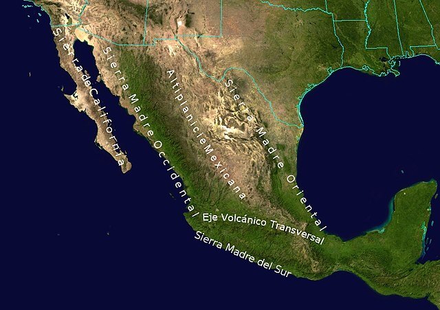
The Sierra Madre System: Mexico's Mountain Backbone
The Sierra Madre System dominates Mexico's topography, creating a natural framework that connects diverse ecological and cultural zones while forming the country's central plateau. This vast network of ranges extends from the United States border in the north to Central America in the south, representing one of the most complex and biodiverse mountain systems in North America.
Sierra Madre Occidental
Stretching from the U.S. border to central Mexico, the Sierra Madre Occidental stands as one of the country's most rugged and ecologically diverse regions. This western range is renowned for its deep canyons, most notably the world-famous Copper Canyon (Barranca del Cobre), which exceeds both the depth and breadth of the Grand Canyon.
The region's landscape is characterized by dense pine and oak forests that provide habitat for an impressive array of wildlife, including jaguars, black bears, and golden eagles. These forests represent some of Mexico's most pristine wilderness areas, where ancient ecosystems continue to thrive despite increasing human pressures.
The Sierra Madre Occidental is perhaps best known as the homeland of the Tarahumara people, also known as the Rarámuri, who have inhabited these mountains for centuries while preserving their traditional lifestyles. Renowned worldwide for their extraordinary endurance running abilities, the Tarahumara navigate treacherous canyon trails barefoot or wearing simple sandals, demonstrating their remarkable harmony with this challenging environment.
Sierra Madre Oriental
Running parallel to the Gulf of Mexico, the Sierra Madre Oriental presents a landscape of dramatic cliffs, verdant valleys, and high plateaus. This eastern range houses some of Mexico's tallest peaks, including the impressive Cofre de Perote and the majestic Pico de Orizaba (Citlaltépetl), which rises to 5,636 meters (18,490 feet), making it Mexico's highest peak and North America's third-highest mountain.
The range's distinctive limestone geology has created extensive cave systems that attract spelunkers and researchers from around the world. These underground networks represent some of the most significant karst formations in North America, containing unique ecosystems and geological features that continue to yield new scientific discoveries.
Beyond its natural wonders, the Sierra Madre Oriental holds immense cultural significance, hosting numerous archaeological sites from ancient Mesoamerican civilizations. These mountain slopes have witnessed the rise and fall of great cultures, their terraced fields and ceremonial centers now standing as monuments to human ingenuity and adaptation.
Sierra Madre del Sur
The Sierra Madre del Sur extends along Mexico's southern Pacific coast, traversing the states of Michoacán, Guerrero, and Oaxaca. This southern range is distinguished by its exceptionally rugged terrain and dense tropical forests, creating a biodiversity hotspot that supports an extraordinary variety of species, including howler monkeys, ocelots, and numerous endemic bird species.
Culturally, the Sierra Madre del Sur serves as home to many Indigenous communities, including the Mixtec and Zapotec peoples. These groups have maintained rich traditions of weaving, pottery, and agricultural practices that trace their origins back centuries, representing living connections to pre-Columbian Mexico.
Throughout Mexican history, these mountains have served as natural refuges for revolutionary movements, their remote valleys and steep terrain providing sanctuary for those seeking to resist external control. From colonial rebellions to the Mexican Revolution, the Sierra Madre del Sur has played a crucial role in the nation's struggle for independence and social justice.
Sierra Madre de Oaxaca
The Sierra Madre de Oaxaca represents an extension of the Sierra Madre Oriental, located primarily within the culturally rich state of Oaxaca. This range is characterized by steep ridges and deep valleys that support remarkably diverse ecosystems, ranging from misty cloud forests to arid scrublands.
The region stands as a center of cultural and linguistic diversity, with numerous Indigenous groups inhabiting its slopes, each maintaining distinct languages, customs, and traditions. This cultural richness reflects thousands of years of human adaptation to the mountain environment, creating one of Mexico's most ethnically diverse regions.
The Sierra Madre de Oaxaca has also gained international recognition for its culinary contributions, most notably mole. This complex traditional sauce represents one of Mexico's most exceptional gastronomic achievements, alongside mezcal, a unique distilled alcoholic beverage derived from the agave plant that has become synonymous with Oaxacan culture.
Sierra Madre de Chiapas
The Sierra Madre de Chiapas extends into Central America as the southernmost range of the Sierra Madre System. This range is characterized by volcanic peaks, including the impressive Tacaná Volcano, which forms part of the Mexico-Guatemala border and represents one of the region's most active geological features.
The mountains are shrouded in lush cloud forests that harbor extraordinary biodiversity, including the magnificent quetzal bird, considered sacred by ancient Maya civilizations, and the elusive tapir, Central America's largest mammal. These cloud forests represent some of the most threatened ecosystems in the Americas, making their protection crucial for global biodiversity conservation.
The Sierra Madre de Chiapas also holds profound cultural significance, featuring ancient Maya ruins such as Bonampak, renowned for its vivid murals that offer unparalleled insights into Maya life, rituals, and artistic achievements. These archaeological treasures demonstrate the sophisticated civilizations that once flourished in these mountain valleys.
Topographic map of Mexico.
The Peninsular Ranges System: Baja California's Mountain Backbone
The Peninsular Ranges extend the full length of the Baja California Peninsula, creating a dramatic coastal landscape where mountains meet both desert and sea. This unique geographical positioning results in extraordinary ecological diversity within a relatively narrow strip of land.
Sierra de Juárez and Sierra de San Pedro Mártir
Located in northern Baja California, the Sierra de Juárez and Sierra de San Pedro Mártir present landscapes characterized by arid conditions interspersed with pine forests at higher elevations. The Sierra de San Pedro Mártir includes Picacho del Diablo, the peninsula's highest peak, which offers spectacular views across the surrounding desert landscape.
These ranges have become increasingly popular destinations for outdoor enthusiasts, offering excellent opportunities for hiking and stargazing. The San Pedro Mártir Observatory, situated at high elevation where atmospheric conditions are ideal, serves as one of Mexico's leading astronomical research centers, contributing to our understanding of the universe from this remote mountain location.
Sierra de la Giganta and Sierra de la Laguna
Moving southward along the peninsula, the Sierra de la Giganta and Sierra de la Laguna display dramatic rock formations and support rich biodiversity despite their arid surroundings. The Sierra de la Laguna, designated as a UNESCO Biosphere Reserve, features a remarkable mixture of desert and tropical ecosystems, supporting numerous species found nowhere else on Earth.
This unique ecological convergence results from the range's position between the Pacific Ocean and the Sea of Cortez, creating microclimates that allow both desert-adapted and tropical species to coexist in close proximity. The resulting biodiversity represents one of Mexico's most significant conservation success stories.
The Trans-Mexican Volcanic Belt: A Continental Divide
One of Mexico's most geologically significant and culturally important mountain systems is the Trans-Mexican Volcanic Belt, which spans central-southern Mexico from the Pacific Ocean to the Gulf of Mexico, between 18°30'N and 21°30'N, covering approximately 1,000 kilometers in length and 90–230 kilometers in breadth. Also known as the Cordillera Neovolcánica, Eje Volcánico Transversal, or Sierra Nevada, this remarkable geological formation serves as a continental divide and represents one of the world's most active volcanic regions.
The cordillera forms the southern boundary of Mexico's Mesa Central and includes numerous volcanic peaks, creating a dramatic landscape that has profoundly influenced Mexico's geography, climate, and human settlement patterns. This volcanic belt is home to Mexico's most iconic peaks, including the towering trio that dominates the central Mexican landscape: Pico de Orizaba, Popocatépetl, and Iztaccíhuatl.
The Trans-Mexican Volcanic Belt plays a crucial role in Mexico's water systems, serving as the primary watershed divide between the Pacific and Atlantic basins. The high-altitude forests and volcanic soils of this range capture and filter enormous quantities of precipitation, feeding the rivers that supply water to over 60 million Mexicans, including the entire Mexico City metropolitan area.
Ecologically, this extensive mountain range running from west to east in the central portion of Mexico supports diverse ecosystems ranging from tropical forests at lower elevations to alpine tundra near the peaks. The volcanic soils are exceptionally fertile, supporting both natural forests and some of Mexico's most productive agricultural regions.
Other Significant Mountain Ranges
Sierra Gorda
The Sierra Gorda, located in the state of Querétaro, forms part of the Trans-Mexican Volcanic Belt and features a landscape of lush mountains covered in a mix of tropical and temperate forests. Recognized as a UNESCO Biosphere Reserve, this range protects numerous endangered species, including jaguars and scarlet macaws, while supporting local communities that depend on sustainable forest management.
The range is also notable for its historic Franciscan missions, architectural gems that illustrate the complex blending of European and Indigenous cultures during the colonial period. These missions represent important examples of colonial architecture adapted to challenging mountain environments.
Sierra Tarahumara
The Sierra Tarahumara, technically a subsection of the Sierra Madre Occidental, deserves special recognition for its Copper Canyon system and its role as the cultural heartland of the Tarahumara people. Beyond its natural beauty, this region holds immense cultural importance as a place where traditional ways of life have endured for centuries despite external pressures and modernization.
The canyons themselves represent some of North America's most spectacular geological formations, carved by rivers over millions of years to create landscapes of breathtaking beauty and ecological significance.
Sierra de Huautla
The Sierra de Huautla, located in south-central Mexico, represents a southern extension of the Trans-Mexican Volcanic Belt. Its rugged terrain and dense forests form part of the Balsas River basin, creating a critical area for biodiversity conservation and watershed protection.
This range demonstrates the critical role that Mexico's mountains play in regional water cycles, capturing moisture from Pacific storms and channeling it through river systems that support millions of people in central and southern Mexico.
Mexico's Highest Peaks
Mexico's towering peaks represent some of North America's most significant mountains, reflecting the country's position along major geological fault lines and volcanic systems. The following list showcases the nation's most impressive summits:
Major Peaks and Elevations
Pico de Orizaba (Citlaltépetl) - 5,636 meters (18,490 feet) - Mexico's highest peak and North America's third-highest
Popocatépetl - 5,426 meters (17,802 feet) - Active volcano near Mexico City
Iztaccíhuatl - 5,230 meters (17,159 feet) - Dormant volcano, part of the Trans-Mexican Volcanic Belt
Nevado de Toluca - 4,680 meters (15,354 feet) - An Extinct volcano with crater lakes
Malinche (Matlalcuéyetl) - 4,461 meters (14,636 feet) - Dormant volcano in Tlaxcala
Nevado de Colima - 4,330 meters (14,206 feet) - Part of the Colima Volcanic Complex
Cofre de Perote - 4,282 meters (14,049 feet) - Shield volcano in Veracruz
Tacaná Volcano - 4,060 meters (13,320 feet) - Active volcano on the Mexico-Guatemala border
Picacho del Diablo - 3,096 meters (10,157 feet) - Highest peak in Baja California
Cerro de la Silla - 1,820 meters (5,971 feet) - Iconic peak near Monterrey
Cerro del Mercado - 2,230 meters (7,316 feet) - Iron-rich mountain in Durango
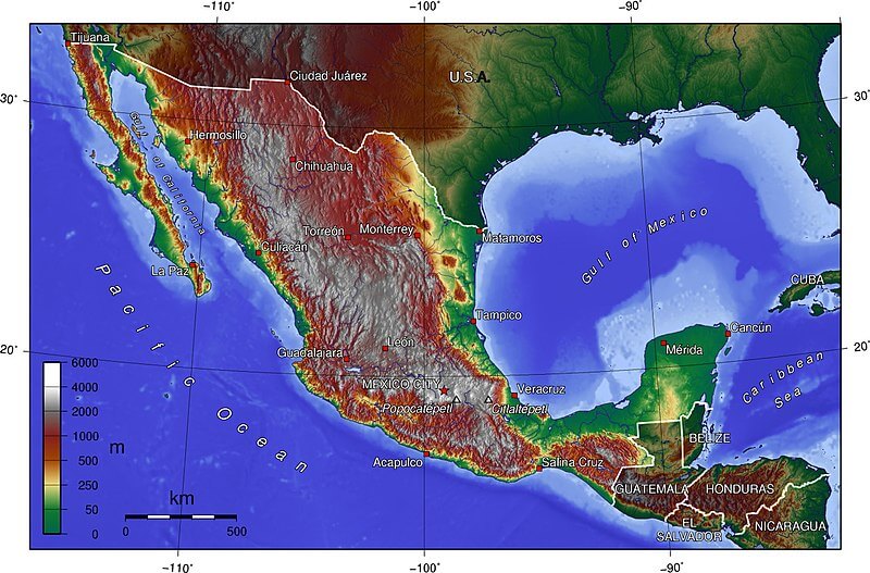
Topographic map of Mexico.
Environmental and Climatic Impacts of Mexico's Mountain Systems
Mexico's mountain ranges function as critical components of the nation's environmental infrastructure, serving roles far beyond their scenic beauty and geological significance. These towering systems serve as climate regulators, biodiversity corridors, and water towers, sustaining both natural ecosystems and human populations across the country.
Water Resources and Watershed Management
Mountain ranges serve as Mexico's primary water towers, capturing moisture from both Pacific and Atlantic weather systems and channeling it through extensive river networks. The high-altitude forests act as natural sponges, absorbing precipitation during wet seasons and gradually releasing it during dry periods, helping to regulate water flow throughout the year.
The volcanic soils of the Trans-Mexican Volcanic Belt, combined with the limestone formations of the Sierra Madre Oriental, create natural filtration systems that purify groundwater and maintain aquifer levels. These mountain watersheds supply water to major population centers, with the central highlands providing water for over 60 million people, including the entire Mexico City metropolitan area.
Community-based conservation efforts in mountain regions have proven essential for water security. Local communities have increasingly recognized that protecting mountain forests directly correlates with maintaining reliable water sources, resulting in successful conservation initiatives nationwide.
Biodiversity Corridors and Species Migration
Mexico's mountain chains function as critical biodiversity corridors, connecting isolated ecosystems and enabling species migration across vast geographical distances. Mountain cloud forests, particularly in regions such as Michoacán, serve as dispersal corridors for numerous species that travel between different habitats, facilitating genetic exchange and supporting ecosystem resilience.
The varied elevation gradients found in Mexico's mountain systems create diverse microhabitats within relatively small geographical areas. This altitudinal diversity allows species to migrate vertically in response to seasonal changes or long-term climate shifts, providing natural adaptation mechanisms that are increasingly important as climate change accelerates.
The "Monarch Corridor" within the Trans-Mexican Volcanic Belt exemplifies the international importance of Mexico's mountain biodiversity corridors. Critical migratory routes of the Monarch butterfly converge in these mountains, supporting one of nature's most remarkable migrations that spans from Canada to central Mexico.
Climate Regulation and Carbon Storage
Mountain forests serve as significant carbon sinks, storing vast quantities of carbon in both vegetation and soils. The dense forests of the Sierra Madre systems, combined with the high-altitude ecosystems of volcanic peaks, contribute substantially to global climate regulation by absorbing atmospheric carbon dioxide and releasing oxygen.
Mountain ranges also create orographic effects that influence regional precipitation patterns. As air masses encounter mountain barriers, they are forced upward, cool, and release moisture, creating the precipitation that sustains both mountain ecosystems and adjacent lowland areas. This natural climate regulation becomes increasingly important as Mexico faces the challenges of climate change.
Threats and Conservation Challenges
Mexico's mountain ecosystems face unprecedented pressures from climate change, deforestation, and human development. Research suggests that without effective conservation measures, Mexico's coastal regions could lose 35 percent of their rainforest cover and 18 percent of their temperate forests, along with significant biodiversity.
Mountain cloud forests are particularly vulnerable to human disturbances such as mining and deforestation, despite their crucial role as biodiversity hotspots and water sources. The specialized nature of cloud forest ecosystems makes them extremely sensitive to environmental changes, with even minor alterations in temperature or humidity potentially causing irreversible damage.
Climate change poses additional challenges, as warming temperatures force species to migrate to higher elevations, ultimately running out of suitable habitat as they approach mountain peaks. This "escalator to extinction" effect threatens numerous endemic species that have evolved in specific mountain environments.
Geological Formation and Tectonic Activity
Mexico's mountain systems reflect the country's position at the intersection of several major tectonic plates, creating a geologically dynamic landscape characterized by ongoing volcanic activity, seismic events, and mountain-building processes. The Trans-Mexican Volcanic Belt, in particular, represents an active convergent margin where the Cocos Plate subducts beneath the North American Plate, generating the volcanic activity that continues to shape central Mexico's landscape.
The Sierra Madre systems, while older than the volcanic belt, continue to experience tectonic influences that contribute to their rugged topography and ongoing geological evolution. These ancient mountain chains preserve evidence of Mexico's geological history, containing rock formations that span hundreds of millions of years and provide insights into past environmental conditions.
Understanding these geological processes is crucial for assessing natural hazards, as Mexico's mountain regions experience frequent seismic activity and volcanic eruptions that can significantly impact human populations and infrastructure. The active nature of these systems also creates fertile soils that support agriculture and contribute to Mexico's ecological diversity.
Mexico's mountain ranges represent far more than geographical features—they embody the nation's natural heritage, cultural diversity, and ecological wealth. From the snow-capped volcanic peaks that dominate the central highlands to the tropical cloud forests of the south, these ranges showcase the extraordinary diversity that makes Mexico one of the world's most biodiverse countries.
The mountains continue to play vital roles in contemporary Mexico, serving as watersheds that supply water to major cities, refuges for endangered species, and guardians of Indigenous cultures that maintain humanity's oldest relationships with the natural world. As Mexico faces the challenges of the 21st century, protecting these mountain ecosystems becomes increasingly crucial not only for the nation but for global environmental health.
Understanding and appreciating Mexico's mountain ranges offers insights into the complex relationships between geology, climate, biology, and human culture that have shaped one of North America's most fascinating countries. These towering landscapes will continue to inspire, challenge, and sustain future generations, just as they have for millennia past.