Guatemala's Diverse Water Bodies: Liquid Landscapes
Guatemala's position between two oceans and rugged terrain has created a diverse and vital water system. From volcanic crater lakes in highland calderas to large freshwater bodies linked to Caribbean waters, these sources are vital for the country's environment, economy, and culture.


The Aquatic Treasures of Guatemala: A Nation Shaped by Water
Guatemala's position between two oceans and its rugged topography have created one of Central America's most diverse and vital hydrological systems. From volcanic crater lakes nestled in highland calderas to the vast freshwater bodies connecting to Caribbean waters, Guatemala's water features are more than just geographic landmarks. These diverse water bodies are vital resources that support the country's environment, economy, and culture. Whether it's crater lakes near volcanoes or rivers flowing through jungles, these waters are key to the nation's identity. Beyond their beauty, they provide essential resources for agriculture, transportation, and the production of hydroelectric power. Guatemala's hydrological wealth includes everything from the deepest volcanic lakes in Central America to extensive river systems that have served as routes for trade and cultural exchange for thousands of years.
Geographic Context and Drainage Systems
Guatemala's water resources are organized into three primary drainage basins, reflecting the country's complex topography and geological history. The hydrographic system is divided into three primary drainage basins. First, the Pacific Ocean drainage basin covers 22% of the country and contains 18 watersheds. The remaining drainage systems flow toward the Atlantic Ocean and the Gulf of Mexico, creating a continental divide that influences everything from climate patterns to the distribution of biodiversity.
Guatemala's coastlines are in the Pacific Ocean to the south and the Caribbean Sea to the east. The Pacific coastline is relatively short, but it offers a range of opportunities for surfing, fishing, and beach tourism. On the Caribbean side, Amatique Bay is a notable feature, providing beautiful coastal landscapes. The positioning between these two significant bodies of water creates distinct climatic zones, which in turn influence the characteristics of the country's inland water systems.
The Volcanic Lake System
Lake Atitlán: The Crown Jewel
Lake Atitlán is a lake in southwestern Guatemala. It lies in a spectacular setting in the central highlands at about 5,128 feet (1,563 metres) above sea level. The lake, 1,049 feet (320 metres) deep, is 12 miles (19 km) long and 6 miles (10 km) wide, with an area of 49.3 square miles (127.7 square km). More precise measurements indicate that the lake has a maximum depth of about 340 metres (1,120 ft) and an average depth of 154 metres (505 ft). Its surface area is 130.1 km2 (50.2 sq mi).
Lake Atitlán represents one of the world's most extraordinary examples of a volcanic caldera lake, formed by catastrophic volcanic activity that created a deep basin subsequently filled with water. The lake's exceptional depth relative to its surface area creates unique thermal and chemical properties that support distinctive ecosystems. Three towering volcanoes—Atitlán, San Pedro, and Tolimán—dominate the lake's shoreline, creating a dramatic amphitheater of water and stone that has captivated visitors for centuries.
The lake's volcanic origins contribute to its remarkable clarity and mineral content, while its high-altitude location at 1,563 m (5,128 ft) above sea level creates a temperate climate despite Guatemala's tropical latitude. The surrounding indigenous communities, primarily Maya Tz'utujil and Kaqchikel peoples, have maintained traditional relationships with the lake for over a millennium, incorporating its waters into their spiritual and economic practices.
Lake Amatitlán: The Thermal Lake
Located just south of Guatemala City, Lake Amatitlán presents a stark contrast to its highland counterpart. Lake Amatitlán, just south of Guatemala City, is smaller and less spectacular. Steam rises from this warm-water lake, and medicinal sulfur springs are found along its banks. The lake's thermal characteristics are a result of ongoing geothermal activity in the region, creating warm waters that support different biological communities than those found in the cooler highland lakes.
Unfortunately, Lake Amatitlán faces significant environmental challenges due to its proximity to Guatemala's largest urban center. Each year, large quantities of untreated sewage, industrial effluent and around 500,000 tons of sediment are carried into Lake Amatitlán through the lake's primary inflow source, the Villalobos River, causing high levels of water pollution and an accelerated rate of eutrophication and siltation. The lake serves as a critical case study for the challenges facing Guatemala's urban water resources and the urgent need for improved environmental management.
The Lowland Lake Complex
Lake Izabal: Guatemala's Largest Water Body
Lake Izabal is a lake in northeastern Guatemala. The country's largest lake, Izabal, occupies part of the lowlands between the Santa Cruz Mountains to the northwest and the Minas and San Isidro mountains to the southwest and southeast. It is fed by the Polochic River and is drained by the Dulce River. Lake Izabal (Spanish pronunciation: [isaˈβal]), also known as the Golfo Dulce, is the largest lake in Guatemala with a surface area of 589.6 km2 (145,700 acres; 227.6 sq mi) and a maximum depth of 18 m (59 ft).
Unlike the deep volcanic lakes of the highlands, Lake Izabal represents an entirely different type of aquatic ecosystem. The lake, which is only a metre above sea level, drains into the Gulf of Honduras of the Caribbean Sea through the smaller Golfo Dulce, which is at sea level, and the navigable Rio Dulce. This near-sea-level elevation and connection to marine waters create a unique brackish environment that supports both freshwater and marine species.
The lake's vast surface area and shallow depth create extensive wetland habitats that serve as critical stopover points for migratory birds and permanent habitat for numerous endemic species. The Polochic River, which feeds the lake, carries nutrients from the highland watersheds, supporting productive fisheries and diverse aquatic plant communities.
Lake Petén Itzá: Gateway to the Maya Biosphere
Lake Petén Itzá is in the north. Its maximum depth is 160 m (520 ft). The lake area experiences high levels of migration due to the presence of natural resources, including wood, chewing gum, and oil, as well as agricultural and pasture activities. Due to its archaeological richness, around 150,000 tourists visit this region each year.
Lake Petén Itzá occupies a unique position in Guatemala's water system, serving as the aquatic heart of the Maya Biosphere Reserve, one of Central America's largest protected areas. The lake's location in the Petén lowlands places it within the greater Mesoamerican Biological Corridor, making it a critical component of regional biodiversity conservation efforts.
The lake's archaeological significance cannot be overstated, as it is situated adjacent to Tikal, one of Guatemala's most important Maya sites and a UNESCO World Heritage site. The relationship between the lake and ancient Maya civilization demonstrates the longstanding importance of water resources in sustaining complex societies in the region.
River Systems and Watersheds
The Motagua River System
Guatemala's eighteen principal rivers, which flow from the mountains to the Pacific Ocean, are relatively short. The Motagua River, flowing east for about 402 kilometers (250 miles), serves as part of the boundary between Guatemala and Honduras. The Motagua represents Guatemala's longest river and serves as the primary drainage for much of the country's eastern highlands.
The Motagua River system demonstrates the dramatic elevation changes characteristic of Guatemala's topography, descending from highland sources at over 3,000 m (9,843 ft) elevation to sea level over its 402 km (250 mi) course. The river's watershed encompasses a diverse range of ecological zones, from cloud forests in the upper reaches to tropical dry forests near the Caribbean coast.
Pacific Watershed Rivers
The Pacific watershed encompasses numerous shorter rivers that drain the volcanic highlands and the southern coastal plain. These rivers, while shorter than their Atlantic counterparts, carry enormous volumes of water during the rainy season and have carved deep valleys through the volcanic terrain. The seasonal nature of Pacific watershed flow patterns creates distinct wet and dry season hydrogeological cycles that influence everything from agricultural practices to hydroelectric power generation.
Ecological and Environmental Significance
Guatemala's water bodies support remarkable biodiversity, serving as habitat for numerous endemic species and providing critical ecosystem services. The country's lakes and rivers support both resident and migratory bird populations, with Lake Izabal and the associated wetlands serving as essential sites of stopover for North American migratory waterfowl.
The thermal stratification in deeper lakes, such as Atitlán, creates distinct habitat zones that support different biological communities at various depths. The volcanic origin of many water bodies contributes unique mineral compositions that influence water chemistry and biological productivity.
Recent human population growth in Guatemala has contributed to the degradation of environmental resources. Since 1900, the country's population has grown from 17 million inhabitants. The watershed of Lake Izabal, eastern Guatemala, also experienced rapid population growth, and with it, the development of intensive agriculture in areas adjacent to the lake. These environmental pressures represent significant challenges for water resource management and conservation.
Economic and Cultural Importance
Guatemala's water bodies provide essential economic resources through fisheries, tourism, transportation, and hydroelectric power generation. Lake Atitlán alone supports significant tourism revenue through its scenic beauty and cultural attractions, while Lake Izabal provides important fisheries resources and serves as a transportation corridor connecting the Caribbean coast with interior regions.
Traditional indigenous communities maintain deep cultural connections with major water bodies, incorporating lakes and rivers into spiritual practices and traditional ecological knowledge systems. These relationships represent millennia of sustainable resource management practices that offer valuable insights for contemporary conservation efforts.
Hydroelectric power generation utilizing Guatemala's river systems provides significant portions of the country's electricity needs, demonstrating the economic importance of maintaining healthy watershed systems. The steep topography and reliable rainfall in many regions create ideal conditions for small-scale hydroelectric development.
Contemporary Challenges and Conservation
Challenges such as pollution and climate change pose a threat to their health. Guatemala's water resources face mounting pressures from population growth, industrial development, and changing precipitation patterns associated with climate change. Urban pollution, agricultural runoff, and deforestation in critical watersheds pose significant threats to water quality and the health of ecosystems.
The case of Lake Amatitlán illustrates the severe impacts that uncontrolled urban development can have on aquatic systems, while emerging eutrophication issues in Lake Izabal demonstrate how agricultural intensification affects even the largest water bodies. Climate change projections suggest shifting precipitation patterns that could dramatically alter the hydrology of both highland and lowland systems.
Conservation efforts are increasingly recognizing the need for integrated watershed management approaches that address land-use practices throughout entire drainage basins. International cooperation, particularly regarding transboundary watersheds such as the Motagua River system, is becoming increasingly important for effective water resource management.
Summary
Guatemala's water bodies represent a remarkable diversity of aquatic ecosystems, reflecting the country's complex geology, topography, and climate. From the profound depths of volcanic Lake Atitlán at 1,563 m (5,128 ft) elevation to the vast shallow expanse of Lake Izabal covering 589.6 km² (227.6 sq mi) at sea level, these water systems support extraordinary biodiversity while providing essential resources for human communities.
The country's three major drainage basins create distinct hydrological regions, each supporting different ecological communities and human uses. The volcanic highland lakes demonstrate remarkable depth and clarity, while lowland systems like Lake Izabal create extensive wetland habitats that serve critical conservation functions. River systems ranging from the 402 km (250 mi) Motagua to shorter Pacific watershed streams provide essential transportation corridors and hydroelectric power generation opportunities.
Contemporary challenges, including urban pollution, agricultural intensification, and climate change, threaten the ecological integrity and economic value of Guatemala's aquatic resources. The transformation of Lake Amatitlán from a pristine mountain lake to a polluted urban water body serves as a warning for other systems, while emerging issues in Lake Izabal demonstrate the need for proactive watershed management.
The cultural and spiritual significance of water bodies to Guatemala's indigenous communities offers valuable insights into sustainable resource management, while the economic importance of tourism, fisheries, and hydroelectric power generation highlights the multiple benefits of maintaining healthy aquatic ecosystems. The successful conservation of Guatemala's water resources requires integrated approaches that address land-use practices throughout entire watersheds while respecting the traditional relationships between human communities and aquatic systems.
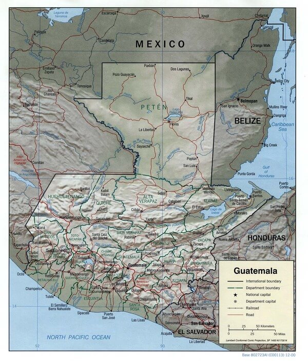
Guatemala relief map.
Significant Water Bodies of Guatemala
Major Lakes
Lake Izabal (Lago de Izabal)
- Size: 589.6 km² (227.6 sq mi)
- Maximum Depth: 18 m (59 ft)
- Elevation: 1 m (3 ft) above sea level
- Location: Northeastern Guatemala, Izabal Department
- Features: Guatemala's largest lake, connects to the Caribbean Sea via Río Dulce
Lake Atitlán (Lago de Atitlán)
- Size: 130.1 km² (50.2 sq mi)
- Maximum Depth: 340 m (1,120 ft)
- Average Depth: 154 m (505 ft)
- Elevation: 1,563 m (5,128 ft) above sea level
- Location: Southwestern Guatemala, Sololá Department
- Features: A Volcanic caldera lake surrounded by three volcanoes
Lake Petén Itzá (Lago Petén Itzá)
- Maximum Depth: 160 m (520 ft)
- Location: Northern Guatemala, Petén Department
- Features: Located near the Tikal archaeological site, part of the Maya Biosphere Reserve
Lake Amatitlán (Lago de Amatitlán)
- Location: South of Guatemala City, Guatemala Department
- Features: Thermal lake with sulfur springs, severely impacted by urban pollution
Major Rivers
Motagua River (Río Motagua)
- Length: 402 km (250 mi)
- Location: Eastern Guatemala, flows to the Caribbean Sea
- Features: Guatemala's longest river forms part of the border with Honduras
Polochic River (Río Polochic)
- Location: Eastern Guatemala
- Features: Major tributary feeding Lake Izabal
Dulce River (Río Dulce)
- Location: Eastern Guatemala
- Features: Drains Lake Izabal to the Caribbean Sea, a navigable waterway
Usumacinta River (Río Usumacinta)
- Location: Northern Guatemala (upper watershed)
- Features: Major river system flowing to the Gulf of Mexico, forms the border with Mexico
Coastal Water Bodies
Amatique Bay (Bahía de Amatique)
- Location: Caribbean coast, Izabal Department
- Features: Important coastal bay on the Caribbean Sea
Pacific Ocean Coastline
- Length: Approximately 254 km (158 mi)
- Location: Southern Guatemala
- Features: Relatively short but important for fisheries and tourism
Secondary Lakes and Lagoons
Laguna Lachuá
- Location: Alta Verapaz Department
- Features: A Circular lake of probable volcanic origin, a national park
Laguna del Tigre
- Location: Petén Department
- Features: Important wetland system in the Maya Biosphere Reserve
Various Crater Lakes
- Location: Throughout volcanic highlands
- Features: Small volcanic lakes formed in extinct volcanic craters