French Guiana's Pristine Aquatic Wilderness: Rivers of the Guiana Shield
French Guiana, on South America's northeastern Atlantic coast, primarily comprises pristine Amazonian land. Its dense, largely unexplored rainforest hosts an intricate network of rivers, coastal waters, and wetlands, creating one of the world's most biodiverse and ecologically essential aquatic ecosystems.


Amazonian Arteries: The Pristine Water Systems of French Guiana
French Guiana, an overseas region of France located on the northeastern Atlantic coast of South America, encompasses 83,534 square kilometers (32,253 square miles) of largely pristine Amazonian territory. This French territory is covered by dense, largely unexplored rainforest, which shelters an intricate network of rivers, coastal waters, and wetlands that collectively constitute one of the most biodiverse and ecologically significant aquatic ecosystems in the world. The territory's water bodies, which flow from the ancient Guiana Shield through vast tropical rainforests to the Atlantic Ocean, represent critical corridors for wildlife, transportation routes for remote communities, and essential components of the Amazon Basin's hydrological cycle.
Atlantic Coast and Coastal Waters
French Guiana's 378 km (235 mi) Atlantic coastline features extensive mudflats, mangrove systems, and estuarine environments, creating unique transitional ecosystems that bridge the terrestrial and marine environments. The coastal waters support rich aquatic biodiversity and serve as critical nursery areas for numerous fish species, while the extensive mangrove forests provide natural coastal protection against erosion and storm surge.
The territory's coastal configuration features numerous rivers that flow directly into the Atlantic, creating complex estuarine systems where freshwater and saltwater meet. These transitional zones support specialized ecosystems adapted to varying salinity levels and tidal influences, contributing to the region's exceptional biodiversity.
Major International Boundary Rivers
The Maroni River System
The Maroni River forms the border between French Guiana and Suriname, originating in the Tumuk Humak Mountains. Spanning approximately 320 miles, this Amazonian river is the royal way to discover fluvial Guiana, marking the border with Suriname and providing a lifeline of exchange for riverside populations, such as the Wayana Indians and Bushinengues. The river's characteristics vary dramatically along its course, sometimes appearing as broad as a lake while other sections meander through rocky terrain featuring rapids and waterfalls known locally as "sauts."
The Maroni serves as both a natural boundary and a cultural bridge, connecting diverse Indigenous communities and supporting traditional ways of life that depend entirely on riverine resources. Navigation along the river requires specialized knowledge of its seasonal variations, rapids, and changing water levels.
The Oyapock River System
The Oyapock River forms the border between French Guiana and the Brazilian state of Amapá, rising in the Tumuc-Humac Mountains and flowing northeast for 311 miles (500 km) to empty into the Atlantic near Cape Orange. The river flows through a remote and pristine region that includes the Guiana Amazonian Park, offering opportunities for ecotourism and adventure activities.
The Oyapock represents one of South America's most pristine international waterways, with vast stretches flowing through completely undeveloped rainforest. The river's basin supports exceptional biodiversity, including numerous endemic species found nowhere else on Earth.
Primary Coastal Rivers
The eight principal rivers of French Guiana, from west to east, include: Maroni, Mana, Iracoubo, Sinnamary, Kourou, Comté-Orapu basins, Approuague, and Oyapock. Each of these river systems contributes unique characteristics to the territory's hydrological landscape.
The Sinnamary River
The Sinnamary River gained particular significance with the construction of the Petit Saut Dam, which created French Guiana's largest artificial reservoir. A dam along the Sinnamary River created this artificial lake in northern French Guiana. This hydroelectric project represents the territory's most significant water management infrastructure, providing renewable energy while creating new aquatic habitats.
The Approuague River
The Approuague River drains substantial portions of French Guiana's interior, flowing through pristine rainforest before reaching the Atlantic. The river supports traditional communities and provides access to otherwise inaccessible regions of the territory's interior.
The Mana River
The Mana River flows through the western regions of French Guiana, creating important wetland systems near its confluence with the Atlantic. These areas support significant bird populations and serve as critical breeding grounds for numerous species.
Interior River Systems and Tributaries
French Guiana's interior contains numerous tributaries and smaller river systems that collectively drain the territory's vast rainforest areas. The comprehensive river network includes the Arataï, Mahury, Orapu, Rivière de Cayenne, Tonnegrande, Montsinéry, Kourou, Koursibo, Counamama, Kokioko, Arouani, Lawa, Grand Abounami, Inini, Tampok, Waki, Litani, Malani, and Wanapi rivers.
These waterways serve essential ecological functions, providing corridors for wildlife movement, supporting aquatic ecosystems, and facilitating the transport of nutrients throughout the rainforest. Many remain largely unexplored and continue to harbor undiscovered species.
Artificial Water Bodies and Infrastructure
Petit Saut Reservoir
The Petit Saut Reservoir, created by damming the Sinnamary River, represents French Guiana's most significant artificial water body. This hydroelectric facility provides renewable energy for the territory while creating new aquatic environments that have attracted diverse wildlife populations.
The reservoir's creation involved flooding substantial areas of pristine rainforest, creating a unique ecosystem where submerged forest structures continue to influence aquatic habitats and support specialized fish communities.
Natural Lakes and Wetland Systems
French Guiana contains a few lakes, including Grand Lac and Lac Eloge, along with numerous seasonal wetlands and permanent swamp systems. These natural water bodies provide critical habitat for waterfowl, amphibians, and numerous other species adapted to freshwater environments.
The territory's wetland systems encompass both permanent and seasonal features, with water levels fluctuating in response to rainfall patterns and seasonal flooding cycles. These dynamic environments support specialized plant and animal communities adapted to changing water conditions.
Transportation and Navigation Networks
Most of this water network can be navigated via small watercraft, and you can cross into Brazil and Suriname across the Oyapock River (in Brazil) and the Maroni River (in Suriname). Rivers serve as primary transportation routes for many remote communities, with traditional dugout canoes and motorized boats providing essential connections to urban areas and neighboring countries.
The river systems support both local transportation needs and international commerce, with regular boat services connecting French Guiana to Suriname and Brazil. These waterways remain the only practical means of access to many interior regions where road infrastructure remains absent.
Biodiversity and Ecological Significance
French Guiana's water bodies support extraordinary biodiversity, including numerous endemic fish species, aquatic plants, and semi-aquatic wildlife. The territory's pristine watersheds provide critical habitat for species ranging from giant river otters to countless invertebrate species found nowhere else on Earth.
The interconnected river systems facilitate genetic exchange between populations and provide migration corridors essential for maintaining healthy ecosystems. Many species depend entirely on specific river characteristics, from particular water chemistry to seasonal flooding patterns.
Conservation Challenges and Opportunities
French Guiana's water systems face pressures from climate change, potential mining activities, and infrastructure development. However, the territory's status as a French overseas region provides unique opportunities for conservation, including access to European Union environmental protections and funding for ecosystem preservation.
The establishment of the Guiana Amazonian Park demonstrates a commitment to protecting significant watersheds, while ongoing scientific research continues to document the exceptional biodiversity supported by the territory's aquatic systems.
Summary
French Guiana's water bodies represent some of South America's most pristine and ecologically significant aquatic systems, encompassing international boundary rivers, coastal estuaries, interior tributaries, and unique wetland environments. The territory's extensive river network, dominated by the Maroni and Oyapock international waterways, provides essential transportation corridors, supports exceptional biodiversity, and maintains traditional ways of life for Indigenous and local communities. From the engineered Petit Saut Reservoir to the countless unnamed streams flowing through the unexplored rainforest, these water systems collectively constitute a critical component of the Amazon Basin's hydrological cycle, while supporting one of the world's most biodiverse ecosystems. As global environmental pressures intensify, French Guiana's water bodies serve as invaluable reservoirs of biodiversity and essential benchmarks for understanding pristine Amazonian aquatic ecosystems.
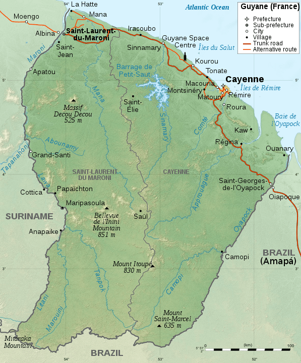
Geographic map of French Guiana.
Notable Water Bodies of French Guiana
International Boundary Rivers
- Maroni River (Marowijne): 612 km (380 mi) total length, ~320 mi (515 km) along French Guiana-Suriname border - Major tributary system, navigable waterway, cultural lifeline for Indigenous communities
- Oyapock River (Oiapoque): 500 km (311 mi) total length, forms French Guiana-Brazil border - Flows from Tumuc-Humac Mountains to Atlantic Ocean near Cape Orange, pristine wilderness corridor
- Lawa River: Upper tributary of Maroni River - Interior borderland, remote Indigenous territories
Major Coastal Rivers (West to East)
- Mana River: Western coastal drainage - Flows through Mana region, supports wetland systems, and bird habitat
- Iracoubo River: Central-western coastal drainage - Flows near Iracoubo commune, agricultural area
- Sinnamary River: Central coastal drainage, dammed for hydroelectric power - Site of Petit Saut Dam and Reservoir
- Kourou River: Central coastal drainage - Flows near Kourou spaceport, a strategic location
- Mahury River: Eastern coastal drainage - Major tributary system near Cayenne
- Approuague River: Eastern coastal drainage - Significant interior watershed, pristine rainforest corridor
- Comté River: Eastern coastal drainage - Part of Comté-Orapu basin system
Major Interior Rivers and Tributaries
- Camopi River: Eastern interior, Oyapock tributary - Remote wilderness area, Indigenous territories
- Inini River: Central interior, Maroni tributary - Flows through the Guiana Amazonian Park
- Tampok River: Interior Maroni tributary - Remote mountainous regions
- Waki River (Ouaqui): Interior tributary - Flows through pristine rainforest
- Grand Abounami River: Interior tributary system - Part of the Maroni watershed
- Arataï River: Interior tributary - Flows near the Cayenne region
- Orapu River: Eastern interior - Part of the Comté-Orapu basin system
- Rivière de Cayenne: Capital region drainage - Urban watershed, includes Rivière des Cascades
- Tonnegrande River: Central drainage - Agricultural and residential areas
- Montsinéry River: Central drainage - Flows near the Montsinéry-Tonnegrande commune
Secondary Rivers and Tributaries
- Koursibo River: Central interior tributary
- Counamama River: Interior tributary system
- Kokioko River: Western interior, Mana tributary
- Arouani River: Western interior tributary
- Litani River: Interior tributary system
- Malani River (Marouini): Interior tributary, alternative name Marouini
- Wanapi River: Interior tributary system
Artificial Water Bodies
- Petit Saut Reservoir: 365 sq km (141 sq mi) - Sinnamary River, the largest artificial water body, hydroelectric facility created in 1994
- Petit Saut Dam: Concrete arch dam, 37 m (121 ft) high - Renewable energy infrastructure
Natural Lakes and Wetlands
- Grand Lac: Interior natural lake - Pristine freshwater ecosystem
- Lac Eloge: Interior natural lake - Remote wilderness location
- Marais de Kaw: Extensive wetland system - Protected natural reserve, exceptional bird habitat
- Pripris wetlands: Coastal and interior seasonal wetlands - Dynamic flooding ecosystems
Coastal and Estuarine Waters
- Atlantic Ocean: 378 km (235 mi) of coastline - French Guiana's northern boundary
- Cayenne Island: Estuarine island system - Capital region, complex tidal channels
- Îles du Salut (Salvation Islands): Offshore island group - Former penal colony, includes Île du Diable (Devil's Island)
- Mudflats and mangrove systems: Extensive coastal wetlands - Critical bird migration stopover, coastal protection
River Basins and Watersheds
- Maroni Basin: Largest watershed system, shared with Suriname - Covers western French Guiana
- Oyapock Basin: Eastern watershed, shared with Brazil - Covers southeastern French Guiana
- Coastal Atlantic Basins: Multiple independent drainage systems - Direct Atlantic Ocean discharge
- Sinnamary Basin: Central watershed - Modified by Petit Saut Dam
- Approuague Basin: Eastern interior watershed - Pristine rainforest drainage
- Mana Basin: Western coastal watershed - Agricultural and conservation areas
Protected Aquatic Areas
- Guiana Amazonian Park: 33,900 sq km (13,090 sq mi) - Protects major watershed systems, the world's largest national park
- Marais de Kaw Nature Reserve: Wetland protection - Critical habitat for waterfowl and wildlife
- Nouragues Natural Reserve: Scientific research station - Protected watershed for biodiversity studies
- Coastal marine protected areas: Various zones - Turtle nesting beaches and marine ecosystem protection
Rapids and Natural Features
- Sauts (Rapids) of various rivers - Natural obstacles and scenic features throughout river systems
- Tumuc-Humac Mountains: Source region - International watershed divide, remote pristine headwaters
- Inselbergs: Ancient rock formations - Create unique microwatersheds and seasonal pools