The Pan-American Highway: Linking North, Central, and South America
Stretching from the frozen tundras of Alaska to the windswept landscapes of Tierra del Fuego, the Pan-American Highway is one of the most extensive and ambitious transportation systems ever conceived, serving as a vital artery for trade, tourism, and cultural exchange across the Americas.


 in Costa Rica at the Panamanian border - by Ll1324, CC0, via Wikimedia Commons")
 https://www.flickr.com/photos/youngrobv/510649828")
The Pan-American Highway: A Continent-Spanning Marvel and the Enduring Enigma of the Darién Gap
From the frozen tundras of Alaska to the windswept landscapes of Tierra del Fuego at the southern tip of South America, the Pan-American Highway is a monumental testament to human ingenuity and the indomitable spirit of connectivity. This vast network of roads, spanning an incredible 48,000 kilometers (nearly 30,000 miles), is one of the most extensive and ambitious transportation systems ever conceived, rivaling the ancient Silk Road's scale and significance.
The Pan-American Highway traverses diverse terrains, from the rugged peaks of the Andes to the lush rainforests of the Amazon. It is a marvel of engineering and international cooperation. Its winding paths facilitate the movement of goods and people and serve as a vital artery for trade, tourism, and cultural exchange across the Americas, fostering economic growth and strengthening bonds between nations.
With each completed section, this colossal undertaking has overcome formidable challenges posed by nature's most unforgiving landscapes, from treacherous mountain passes to vast expanses of arid deserts. Yet, through perseverance and unwavering determination, the Pan-American Highway continues to evolve, connecting remote communities and bridging geographical divides, symbolizing humanity's relentless pursuit of progress and unity.
A Vision Realized: Connecting the Continents
The Origins and Construction of the Pan-American Highway
The idea of a continuous route linking the nations of North, Central, and South America can be traced back to the early 19th century when visionary thinkers first proposed this ambitious concept. However, it wasn't until the early 20th century that this dream took tangible form, as different countries assumed responsibility for constructing their respective sections of what would become the Pan-American Highway.
The first significant milestone was achieved in 1930 when the initial stretch between Laredo, Texas, and Mexico City was completed, paving the way for future progress. Over the following decades, a remarkable international effort unfolded, with nations collaborating to overcome formidable challenges posed by diverse landscapes, from towering mountain ranges to arid deserts and logistical hurdles.
Through perseverance and engineering ingenuity, the Pan-American Highway gradually took shape, with each completed section representing a triumph of human determination and a testament to the power of international cooperation. Significant milestones included completing the Inter-American Highway segment through Central America in the 1960s and the final link between Panama City and Chepo, Panama, in 2016, marking the realization of a dream nearly two centuries ago.
The Inter-American Highway: A Vital Link
The Inter-American Highway is a crucial transportation artery that forms the Central American segment of the more extensive Pan-American Highway network. Spanning approximately 5,390 kilometers (3,350 miles), this remarkable feat of engineering connects Nuevo Laredo, Mexico, to Panama City, Panama, traversing through the heart of Mexico, Guatemala, El Salvador, Honduras, Nicaragua, Costa Rica, and Panama.
The idea for this ambitious project was first conceived in 1923. Still, it wasn't until the late 1930s that construction began in earnest, driven by the United States' strategic interests during World War II. The U.S. Army Corps of Engineers played a pivotal role in building sections of the highway, initially dubbed the "Military Road," to aid the war effort. While many sections were built independently by individual countries before 1940, the U.S. provided funding and engineering assistance to connect the gaps, particularly in Central America.
Despite immense challenges posed by the remote terrain, mountains, rivers, and jungles and a lack of local infrastructure, supplies, and labor issues, the Inter-American Highway was largely drivable by the late 1940s. However, it wasn't until 1963 that the entire route was completed as a continuous highway from Mexico to Panama, with the final section in Costa Rica being paved in 1967. This monumental achievement facilitated transportation and trade between Central America and North and South America.

Map depicting the route of the Pan-American Highway.
The Darién Gap: Nature's Formidable Barrier
The Missing Link and Environmental Concerns
Despite the monumental achievements of the Pan-American Highway and the Inter-American Highway, a formidable obstacle remains – the Darién Gap, a 160-kilometer (100-mile) stretch of dense rainforest and treacherous swamps that separates Panama and Colombia. This bleak and rugged region, renowned for its exceptional biodiversity and home to Indigenous communities, has long thwarted attempts to complete the highway's unbroken journey, serving as a natural barrier that has defied human ingenuity.
Proposals to build a road through the Darién Gap have faced fierce opposition from environmental groups and indigenous communities, igniting a complex debate that pits development against conservation. Environmental advocates argue that such construction would damage the delicate rainforest ecosystem, threatening the survival of countless plant and animal species that thrive in this biological hotspot. Furthermore, they warn of the potential for deforestation, soil erosion, and the disruption of fragile water systems that sustain the region's rich tapestry of life.
On the other hand, indigenous communities, who have called the Darién Gap home for centuries, fear the encroachment of modern development and the potential exploitation of their ancestral lands. They raise concerns about the disruption of their traditional way of life, the loss of cultural heritage, and the possible displacement of their communities, which have coexisted harmoniously with the rainforest for generations.
As the debate continues, the Darién Gap remains an enigmatic and formidable barrier, a testament to nature's resilience and the complexities of balancing human ambition with environmental preservation. Finding a solution that satisfies all stakeholders and protects this ecological treasure while facilitating connectivity remains a daunting challenge that will require innovative thinking, compromise, and deep respect for the delicate balance between progress and sustainability.
A Legacy of Connectivity and Cooperation
The Pan-American Highway's Enduring Impact
Beyond its physical infrastructure, the Pan-American Highway and its integral components, such as the Inter-American Highway, have left an indelible mark on the Americas, transcending their role as mere transportation arteries. This colossal undertaking has fostered cooperation and unity among nations, transcending borders and cultural divides and weaving a tapestry of shared experiences and mutual understanding.
As travelers embark on their journeys along the winding paths of the Pan-American Highway, they are immersed in a living museum that showcases the rich tapestry of cultures, traditions, and landscapes that define the American continents. From the vibrant markets of Mexico, where the aroma of spices and the rhythms of mariachi music fill the air, to the snow-capped peaks of the Andes, where ancient Incan ruins stand as silent sentinels, the highway serves as a gateway to a world of cultural exploration and self-discovery.
Along the way, travelers encounter the resilience and hospitality of the people who call this vast region home, each community offering a unique glimpse into their way of life, customs, and stories. Whether it's the colorful textiles of Guatemalan weavers, the mouth-watering cuisine of Peruvian chefs, or the captivating rhythms of Brazilian samba, the Pan-American Highway serves as a conduit for cultural exchange, fostering a deeper appreciation for the diversity that defines the Americas.
Beyond its practical utility, the Pan-American Highway has become a symbol of unity and interconnectedness, a testament to the human spirit's ability to overcome geographical barriers and forge lasting bonds. As travelers traverse its paths, they witness the wonders of the natural world and gain a profound understanding of the shared hopes, dreams, and aspirations that bind the nations of the Americas together. Together, they create a tapestry of unity that transcends borders and celebrates the richness of our collective heritage.
Conclusion
The Pan-American Highway is a testament to human perseverance, ingenuity, and the enduring quest for connectivity. From its humble beginnings as a visionary idea to its present-day grandeur, this colossal network of roads has woven together nations, facilitated trade and cultural exchange, and opened new horizons for exploration and understanding. While challenges like the Darién Gap remain, the Pan-American Highway's legacy is a powerful reminder of what can be achieved through international cooperation and a shared commitment to overcoming physical and symbolic boundaries.
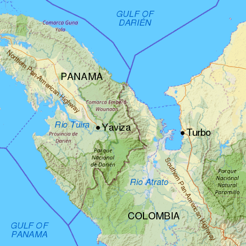
Map showing the Darién Gap break in the Pan-American Highway between Yaviza, Panama and Turbo, Colombia.