
The Caribbean Sea: Ocean Dynamics and Marine Ecosystems of the American Mediterranean
The Caribbean Sea is a semi-enclosed marine basin of extraordinary depth and complexity, with four deep trenches, powerful current systems, and centuries of pirate and treasure-fleet history that complement the islands and cultures covered in our Caribbean Archipelago article—together telling the full story of one sea shaped as much by water as by land.
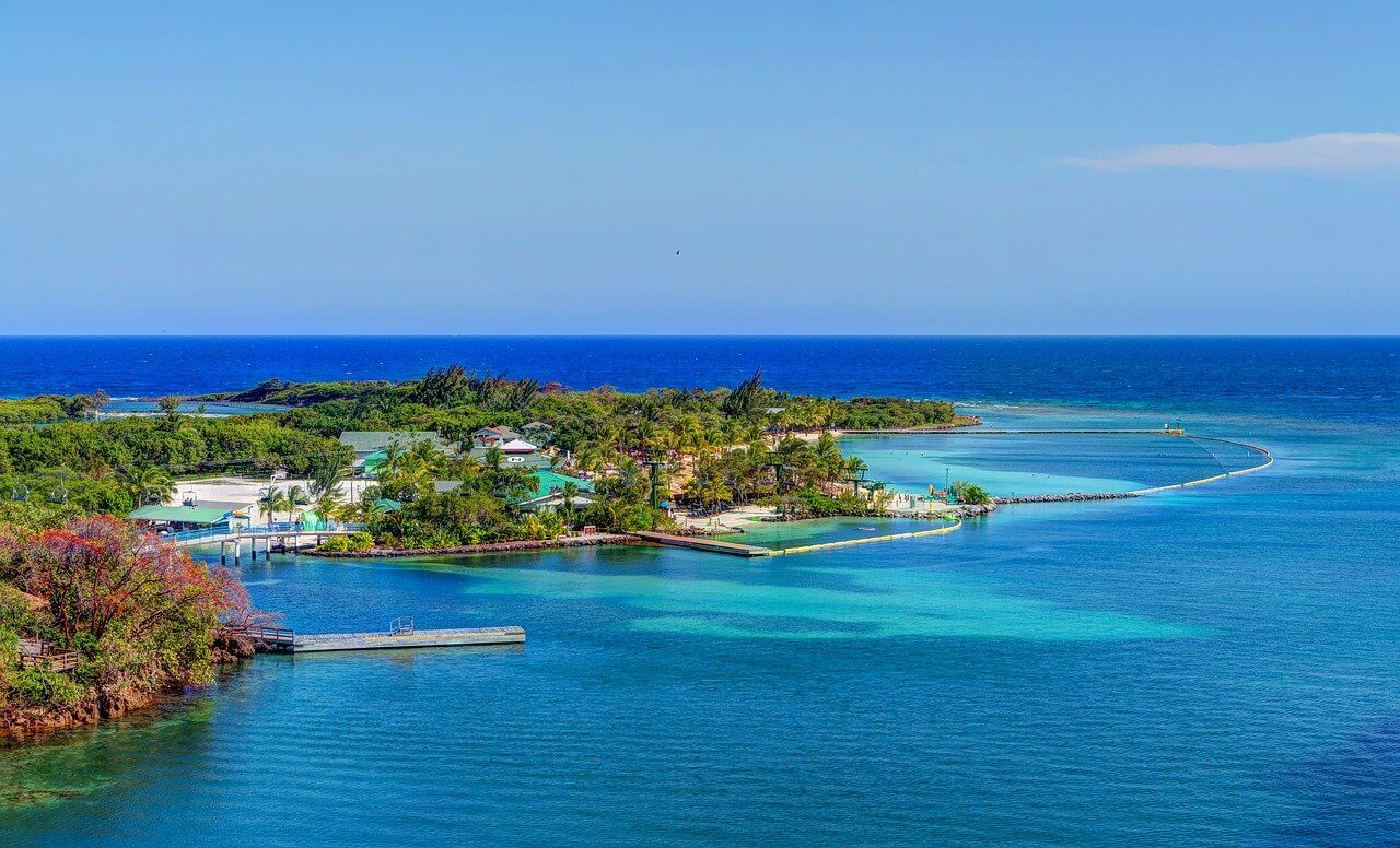
The Caribbean Sea: Currents, Commerce, and the Deep Basins Beneath the Waves
The Caribbean Sea stands as one of the world's most fascinating semi-enclosed marine basins. This tropical oceanic realm bridges two vast continents and harbors extraordinary biodiversity within its azure waters. Covering approximately 2.75 million square kilometers (1.06 million square miles), this remarkable sea stretches between North and South America, creating a unique marine environment that has shaped maritime history, supported diverse ecosystems, and continues to influence regional climate patterns across the Western Hemisphere.
Unlike the vast expanses of open ocean, the Caribbean Sea's semi-enclosed nature creates a distinct oceanographic character. Bounded by the Bahamas and Florida Keys to the northwest, Central America to the west, South America to the south, and the thousands of islands of the Caribbean Archipelago to the north and east, this marine basin functions as a complex system where oceanic currents, freshwater inputs, and atmospheric forces converge. That same archipelago—its geology, islands, terrestrial biodiversity, and human cultures—is covered in full in our dedicated article; this piece focuses on the sea itself, from its deepest trenches to its centuries of maritime commerce.
A Basin Shaped by Three Colliding Plates
The Caribbean Sea's character as a semi-enclosed basin stems from a geological history beginning roughly 130 million years ago, during the Cretaceous period, at the convergence of the North American, South American, and Caribbean plates—the same tectonic collision covered in more geological depth, and as it shaped the islands themselves, in our Caribbean Archipelago article. What matters for the sea itself is the result: neither fully enclosed like the Mediterranean nor fully open like the Atlantic, restricted to relatively narrow connections with the wider ocean that give the Caribbean its distinctive oceanographic behavior.
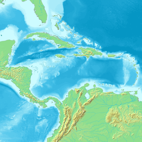
Topographic map of the Caribbean Basin.
Four Deep Basins Beneath the Waves
The Caribbean Sea consists of four deep basins that create a complex underwater topography rivaling any terrestrial mountain range. The deepest point, the Cayman Trench, plunges to 7,686 m (25,217 ft) below sea level, the deepest point in the Caribbean and among the deepest trenches in the Atlantic Ocean system, formed through transform fault activity between the North American and Caribbean plates.
The Colombian Basin, in the southern Caribbean, reaches depths of approximately 4,000 m (13,123 ft) across roughly 330,000 sq km (127,413 sq mi) and receives significant freshwater input from South American rivers, creating distinctive hydrographic conditions. The Venezuelan Basin, along the northern coast of South America, extends to 5,420 m (17,782 ft) and serves as a critical pathway for deep-water circulation connecting the Caribbean to the broader Atlantic. The Yucatán Basin, in the western Caribbean, reaches 4,384 m (14,383 ft) and plays a crucial role connecting Caribbean waters with the Gulf of Mexico through the Yucatán Channel.
Currents That Shape a Continent's Climate
The Caribbean Sea's semi-enclosed nature creates distinctive circulation patterns that differ markedly from open ocean systems. The primary circulation is driven by the Caribbean Current, entering the basin through passages between the Lesser Antilles and flowing generally westward at 15-30 centimeters per second (0.3-0.6 knots), transporting approximately 30 million cubic meters (1.06 billion cubic feet) of water per second, making it one of the most significant current systems in the tropical Atlantic.
The Loop Current connects the Caribbean to the Gulf of Mexico through the Yucatán Channel, where Caribbean waters flow northward into the Gulf before exiting through the Florida Straits to join the Gulf Stream, a vital link in the Atlantic's thermohaline circulation. Upwelling zones along the Venezuelan and Colombian coasts, where deep, nutrient-rich waters rise to the surface, support some of the Caribbean's most productive marine ecosystems and important commercial fisheries.
Surface water temperatures remain relatively constant year-round, ranging from 26-29°C (79-84°F), with minimal seasonal variation given the region's proximity to the equator. Deep water temperatures below 1,000 m (3,281 ft) remain stable at 4-5°C (39-41°F), while salinity increases with depth before decreasing slightly in the deepest basins. The Amazon and Orinoco River plumes significantly influence Caribbean water properties, particularly in the southern and eastern basin. These massive freshwater inputs can extend hundreds of kilometers from the South American coast, and the Amazon plume in particular can stretch across the entire width of the Caribbean during peak discharge, creating a lens of less saline water that affects both hurricane development and marine productivity.
Life Beneath the Waves
The Caribbean's coral reefs, including the Mesoamerican Barrier Reef System, the second-largest reef system in the world, and the region's terrestrial biodiversity are covered in depth in our Caribbean Archipelago article. The sea's open waters and depths, however, support their own communities. Large migratory pelagic species use the Caribbean as a critical transit corridor, including yellowfin tuna (Thunnus albacares), common dolphinfish (Coryphaena hippurus), and various billfish that support significant commercial and recreational fisheries.
Roughly 30 marine mammal species inhabit Caribbean waters, from small coastal dolphins to large baleen whales; humpback whales (Megaptera novaeangliae) migrate here from North Atlantic feeding grounds specifically to mate and calve in the warm tropical water, while the critically endangered West Indian manatee (Trichechus manatus), with fewer than 10,000 individuals estimated to remain, depends on coastal areas and river systems throughout the region.
Far below the surface, the Cayman Trench harbors hydrothermal vent communities among the deepest known chemosynthetic ecosystems in the Atlantic, supporting specialized tube worms, vent crabs, and bacterial mats that derive energy from chemical processes rather than sunlight. Deep-water coral communities, including Lophelia pertusa and other cold-water species, build complex three-dimensional habitats that support diverse fish assemblages and serve as significant carbon storage systems in the deep sea. However, recent expeditions have also revealed widespread plastic, metal, and glass debris even in these remote depths, a sobering reminder of how far human impact now extends.
The Caribbean as Hurricane Engine
The Caribbean Sea's semi-enclosed nature and tropical location make it a critical region for Atlantic hurricane formation and intensification. Approximately 60% of major Atlantic hurricanes either form within or strengthen significantly while passing through Caribbean waters, drawing on the thermal energy of surface waters typically 26°C (79°F) or higher. The Caribbean Low-Level Jet, a summer wind pattern, influences both hurricane activity and regional precipitation, while the basin's bathymetry and current patterns mean hurricane intensity can change rapidly as storms interact with deep, warm central waters or nearby landmasses.
Current sea-level rise in the Caribbean measures 3.40 ± 0.3 mm per year (1993-2019), close to the 3.25 ± 0.4 mm global mean, but the basin's restricted water exchange with the broader Atlantic can concentrate both heat and rising water within it, potentially producing more severe local impacts than in open-ocean settings. Thermal expansion alone can add 10-15 cm (4-6 in) to local sea levels during summer months, worsening coastal flooding and erosion.
Maritime History: Treasure Fleets and Pirates
The Caribbean Sea's semi-enclosed nature made it a natural maritime highway during the colonial period, with Spanish, English, French, and Dutch powers establishing trade networks connecting Europe, Africa, and the Americas. The sea's numerous islands, sheltered harbors, and strategic chokepoints created ideal conditions for both legitimate trade and piracy alike. Spanish treasure fleets rode the Caribbean Current westward toward Mexican ports before catching the Gulf Stream north to Spain, carrying the gold and silver that funded the Spanish Empire, while sugar plantation economies across the islands relied on the sea to move enslaved people, raw materials, and finished goods within the broader transatlantic triangle trade.
That same geography, thousands of islands, hidden coves, and unmarked channels, made the Caribbean ideal for piracy through the 17th and early 18th centuries. Port Royal, Jamaica, once known as the "wickedest city on Earth," served as a major pirate haven until an earthquake destroyed it in 1692, while Tortuga Island off the coast of Haiti became another notorious pirate stronghold, a quasi-independent maritime community operating largely outside governmental control.
A Modern Crossroads of Global Trade
Today, the Caribbean Sea remains a crucial link in global maritime trade, with major shipping lanes connecting North American and European markets to South American and Asian economies. The Panama Canal routes approximately 6% of global trade through Caribbean waters, while container shipping through ports including Miami, San Juan, Kingston, and Cartagena handles millions of tons of cargo annually. Cruise tourism has transformed the sea into one of the world's most visited maritime destinations, with over 30 million passengers visiting Caribbean ports each year, a scale of activity that dwarfs anything in the region's earlier maritime history.
Fisheries, Oil, and the Blue Economy
The Caribbean supports commercial fisheries valued at over $400 million annually, though the basin's limited connectivity to other ocean systems leaves fish populations especially vulnerable to overexploitation. Pelagic fisheries target yellowfin and skipjack tuna (Katsuwonus pelamis) and dolphinfish, while reef-associated fisheries for Nassau grouper (Epinephelus striatus), snapper, and Caribbean spiny lobster (Panulirus argus) supply crucial protein for coastal populations, even as many reef fish populations have declined significantly from overfishing and habitat loss. Queen conch (Strombus gigas) fisheries, with annual harvests exceeding 1,000 tons in shell weight, represent one of the region's most valuable marine resources, though the species' dependence on seagrass habitat makes it especially vulnerable to coastal development.
Beneath the seafloor, proven oil reserves exceed 13 billion barrels and natural gas reserves approach 55 trillion cu ft, concentrated along the continental margins. Trinidad and Tobago produces roughly 60,000 barrels of oil daily from offshore Caribbean fields, while Colombia and Venezuela operate significant offshore facilities of their own. Renewable energy potential is considerable as well, with average wind speeds of 7-9 meters per second (16-20 mph) drawing growing interest in offshore wind development. The Caribbean's biodiversity has also attracted biotechnology researchers: marine sponges abundant on Caribbean reefs have yielded compounds with anti-cancer, anti-viral, and antibiotic properties, several currently in clinical trials, while aquaculture development focused on species like cobia (Rachycentron canadum) takes advantage of the region's warm, nutrient-rich waters.
A Sea Under Pressure
The Caribbean faces mounting environmental pressure on multiple fronts. Recent deep-sea expeditions have found plastic, metal, and glass debris throughout the water column, even at the greatest depths, while agricultural runoff introduces excessive nutrients that fuel eutrophication and harmful algal blooms, and heavy maritime traffic raises the ongoing risk of a catastrophic oil spill.
Rising ocean temperatures have triggered repeated major coral bleaching events in 1995, 1998, 2005, 2010, 2014-2017, and 2023, with some reef systems losing over 80% of coral cover. Ocean acidification has already lowered Caribbean seawater pH by approximately 0.1 units since pre-industrial times, threatening the calcification processes corals and other shelled organisms depend on, while sea level rise particularly threatens low-lying coral cays and the coastal mangrove systems that serve as critical nursery habitat.
In response, the region has established marine protected areas covering approximately 20,000 sq km (7,722 sq mi) of habitat, and the Caribbean Challenge Initiative, a commitment from 23 Caribbean countries and territories to protect 20% of marine and coastal environments by 2030, represents an unprecedented degree of regional cooperation on ocean conservation. Sea turtle conservation programs and coral restoration efforts, including genetic rescue and assisted-evolution techniques aimed at breeding heat-tolerant coral, continue alongside this broader push.
Conclusion: A Small Sea With an Outsized Reach
The Caribbean Sea's 2.75 million sq km demonstrate how a relatively modest ocean basin can have an influence far exceeding its size: generating hurricanes that affect the entire Atlantic, hosting more than 10% of the world's marine biodiversity, and serving for five centuries as one of the most consequential maritime crossroads on Earth. Its future, like that of the islands and cultures covered in our Caribbean Archipelago article, will depend on how well the nations that share it can translate the region's long history of adaptation into the sustained cooperation its coral reefs, fisheries, and coastal communities now need.
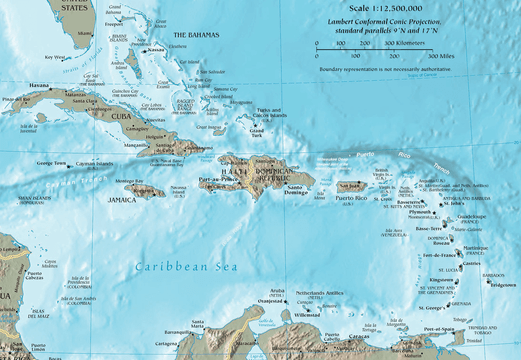
Map of the Caribbean Region.