
The Sierra Madre Occidental: Mexico's Majestic Western Backbone
The Sierra Madre Occidental, Mexico's largest mountain range, spans the U.S.-Mexico border through Sonora and Chihuahua to Jalisco and Michoacán, a rugged volcanic backbone whose canyons, forests, and mineral wealth have shaped both the region's ecology and its complicated modern history.

Rugged Peaks and Deep Canyons: Exploring the Sierra Madre Occidental
The Sierra Madre Occidental, the most extensive mountain range in Mexico, stretches for over 1,250 km (780 mi) along the country's western edge, from the U.S.-Mexico border to the states of Jalisco and Michoacán. As one of the ranges comprising the Sierra Madre Mountain System, it complements the Sierra Madre Oriental to the east and the Sierra Madre del Sur to the south, collectively forming the backbone of Mexico's diverse geography. This interconnected system serves as a natural divider, shaping the country's climate, ecosystems, and human settlement patterns. Among these ranges, the Sierra Madre Occidental stands out for its breathtaking landscapes, rich biodiversity, and cultural importance.
A Vast Mountain System
The Sierra Madre Occidental runs parallel to Mexico's Pacific coastline, forming the western boundary of the Central Mexican Plateau. The range's elevation varies widely, with many peaks exceeding 3,000 m (9,843 ft), and its terrain is rugged and dramatic, characterized by steep cliffs, expansive plateaus, and an intricate network of rivers and valleys. One of the range's most notable features is the Copper Canyon (Barranca del Cobre), a complex system of six interconnected canyons located in the state of Chihuahua. Larger and deeper than the Grand Canyon in the United States, Copper Canyon's sheer size and stunning beauty make it a natural wonder that draws tourists, adventurers, and researchers from around the globe.
The Continental Divide
A critical aspect of the Sierra Madre Occidental is its role in the Continental Divide of the Americas, which determines the direction of water flow on either side of the range. To the west, rivers like the Yaqui, Mayo, and Fuerte flow toward the Gulf of California and the Pacific Ocean, supporting agriculture and ecosystems in the arid regions of northwestern Mexico. To the east, smaller streams feed into basins that connect to larger rivers, such as the Río Bravo and the Río Lerma, which eventually flow into the Gulf of Mexico. This division has significant ecological and economic implications, shaping the diverse climates and ecosystems on either side of the range while sustaining human settlements and agricultural practices.
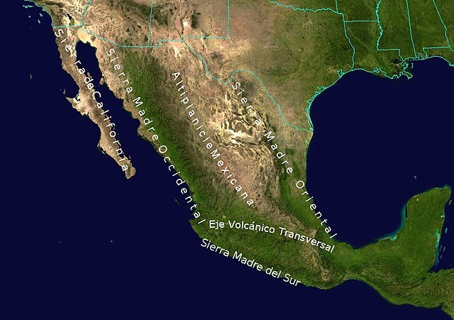
Topographic map of Mexico: Sierra Madre System.
Diverse Climates and Ecosystems
The Sierra Madre Occidental spans multiple climatic zones, from arid deserts in the north to temperate and tropical regions in the south. At higher elevations, the range is dominated by pine-oak forests, part of the broader Sierra Madre Evergreen Forests ecosystem and one of North America's largest continuous forest ecoregions. These forests thrive in the cooler, wetter conditions created by Pacific air currents and are critical to the region's biodiversity. At lower elevations, the landscape transitions into tropical deciduous forests, thorn scrublands, and grasslands, sustained by seasonal rainfall, particularly during the summer months, that supports a wide array of plant and animal species.
A Biodiversity Hotspot
The Sierra Madre Occidental is a haven for wildlife, boasting over 200 bird species and numerous mammals, reptiles, and amphibians. Among its most notable endemic and characteristic species are the thick-billed parrot (Rhynchopsitta pachyrhyncha), one of only two parrot species native to the United States and Mexico border region and now largely restricted to the high pine forests of this range, the elegant trogon (Trogon elegans), and the jaguar (Panthera onca), which still ranges through the more remote canyon country. Copper Canyon itself supports rare plants, including orchids and agaves, and its high-elevation streams shelter the Mexican golden trout (Oncorhynchus chrysogaster), a critically endangered species found nowhere outside the headwaters of the Fuerte, Sinaloa, and Culiacán rivers and increasingly threatened by habitat degradation and hybridization with introduced rainbow trout. The forests and rivers of the Sierra Madre Occidental play an essential role in maintaining regional ecological balance, acting as carbon sinks and water reservoirs for the surrounding lowlands.
Water Resources
The Sierra Madre Occidental is critical to Mexico's hydrology. Rivers originating in the range are lifelines for millions of people, supporting agriculture, hydroelectric power, and drinking water supplies. The western-flowing rivers irrigate fertile agricultural regions in states like Sonora and Sinaloa, while eastern tributaries sustain the semi-arid central plateau. Copper Canyon's rivers, including the Urique and Batopilas, contribute to this hydrological network and shape the dramatic landscapes that define the region.
Cultural and Historical Importance
For millennia, the Sierra Madre Occidental has been home to Indigenous peoples, including the Tarahumara (Rarámuri) of Copper Canyon. The Tarahumara are renowned for their endurance running, traversing the rugged terrain barefoot or in simple sandals, and their culture remains deeply intertwined with the environment, reflected in their spiritual beliefs, farming practices, and ceremonies. Traditional Tarahumara dwellings, including cliffside caves and log cabins, demonstrate their adaptation to the challenging mountainous environment, while festivals marked by dance and music celebrate natural cycles and community life.
During the colonial period, the Sierra Madre Occidental was a significant source of silver, gold, and other minerals. Mining towns such as Parral and Batopilas flourished, leaving behind architectural remnants that hint at the wealth extracted from the region. In the 20th century, the mountains served as refuges for revolutionary movements and Indigenous resistance, underscoring their role as a natural stronghold in Mexico's tumultuous history—a role the range has continued to play, in a very different sense, over the past several decades.
A Complicated Modern Economy: Mining, Agriculture, and the Golden Triangle
Mining continues to be a dominant industry in the Sierra Madre Occidental, which remains rich in silver, gold, copper, and zinc; while mining contributes significantly to local economies, it also poses environmental and social challenges, including deforestation, water contamination, and conflicts with Indigenous communities. The lower elevations and valleys support agriculture as well, with corn, beans, and wheat as staple crops alongside significant coffee and agave cultivation, the latter of which feeds into Mexico's tequila and mezcal industries.
The Sierra Madre Occidental is also, more soberly, the geographic core of what is widely known as Mexico's "Golden Triangle," the border region where the states of Sinaloa, Durango, and Chihuahua meet. The area's remoteness, rugged terrain, and limited state presence—the same qualities that have long protected its biodiversity and sheltered the Tarahumara from outside disruption—have also made it a historic center of opium poppy cultivation and drug trafficking for well over a century, dating back to Chinese immigrant farmers who introduced poppy cultivation in the late 19th and early 20th centuries. This history has real consequences for the region today, shaping security conditions, land use, and the degree of outside access across large parts of the range, and it remains a significant factor in the daily lives of many rural and Indigenous communities who live there.
Tourism
The Sierra Madre Occidental, particularly Copper Canyon, is a major tourist destination. The Chepe train (Chihuahua al Pacífico Railway) offers an unparalleled journey through the canyons, showcasing dramatic views, remote villages, and cultural landmarks, while adventure tourism, including hiking, rock climbing, and zip-lining, attracts visitors from around the world. Tourism infrastructure remains concentrated around Copper Canyon and a handful of other accessible areas, in part a reflection of the security realities that limit development and access elsewhere in the range.
Environmental Challenges
The Sierra Madre Occidental faces several environmental threats. Logging and agricultural expansion have led to significant forest loss, threatening biodiversity, while modern mining operations often result in soil and water contamination that affects both wildlife and downstream communities. Rising temperatures and shifting rainfall patterns tied to climate change are also beginning to disrupt ecosystems and water availability across the range. Efforts to address these challenges include reforestation projects, the establishment of protected areas, such as the La Michilía Biosphere Reserve in Durango, and sustainable tourism initiatives that generate conservation-aligned income for local communities.
Conclusion
The Sierra Madre Occidental is a cornerstone of Mexico's natural and cultural heritage. Its towering peaks, expansive forests, and deep canyons create a landscape of unparalleled beauty and ecological importance, sustaining biodiversity, shaping hydrological systems, and supporting both Indigenous communities and modern industries. Yet its story is not one of unclouded grandeur alone: the same remoteness that has preserved its ecological and cultural richness has also made it a center of Mexico's drug economy, a duality that will continue to shape how the range is understood, governed, and protected in the years ahead. Preserving the Sierra Madre Occidental's ecological balance and cultural significance, while addressing the security and economic realities facing the communities who call it home, will be essential as Mexico moves into the future.