Guyana's Diverse Aquatic Landscapes: From Highlands to Coast
Guyana features a diverse range of landscapes, from Atlantic coastlands to Amazonian rainforests and highland savannas. It is known as the "Land of Many Waters," emphasizing its extensive network of rivers and waterways that collectively shape the country's geography, economy, and culture.


 https://www.flickr.com/photos/amanderson/16429077158")


Rivers of Gold: The Magnificent Water Systems of Guyana
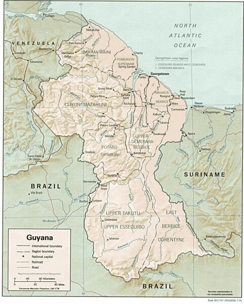
Guyana, the only English-speaking nation in South America, encompasses 214,970 square kilometers (83,000 square miles) of diverse landscapes, ranging from Atlantic coastlands to Amazonian rainforests and highland savannas. This South American nation is renowned as the "Land of Many Waters," a designation that reflects its extensive network of rivers, creeks, and waterways, which collectively shape the country's geography, economy, and cultural identity. Guyana has four main rivers – the Berbice, Corentyne, Demerara, and Essequibo – and a host of smaller rivers, creeks, and streams, creating an intricate hydrological system that supports diverse ecosystems, facilitates transportation, and provides the foundation for a range of economic activities, from agriculture to gold mining.
Atlantic Coast and Coastal Waters
Guyana's 459 km (285 mi) Atlantic coastline features extensive mudflats, mangrove systems, and river estuaries, creating dynamic transitional environments that bridge the terrestrial and marine ecosystems. The coastal plain, extending inland for 16-64 km (10-40 mi), lies mostly below sea level and depends entirely on an elaborate system of sea walls, drainage canals, and sluice gates for protection against flooding.
The Berbice, Demerara, and Essequibo Rivers are navigable by oceangoing vessels for 150 km, 100 km, and 80 km, respectively, making these waterways crucial for international commerce and inland transportation. The coastal rivers create broad estuaries where freshwater meets the Atlantic, supporting rich marine ecosystems and providing natural harbors for maritime activities.
The Essequibo River System
The Essequibo River stands as Guyana's largest and most significant waterway, draining approximately two-thirds of the country's territory. It enters the Atlantic 21 kilometres (13 mi) from Georgetown, the capital city of Guyana. The river features Murrays Fall, Pot Falls, Kumaka Falls, and Waraputa Falls. Its many tributaries include the Rupununi, Potaro, Mazaruni, Siparuni, Kuyuwini, Konawaruk and Cuyuni rivers.
The Essequibo's vast watershed encompasses the country's interior highlands, collecting water from the ancient Guiana Shield and channeling it through pristine rainforests and savannas. The river's numerous falls and rapids create spectacular natural features while also providing potential sites for hydroelectric development.
Major Essequibo Tributaries
Other significant rivers include the Potaro, Cuyuni, Mazaruni, and Rupununi Rivers, all of which are tributaries of the Essequibo River and drain the northwestern parts of the country. Each tributary system contributes unique characteristics to the Essequibo's overall flow and supports distinct regional ecosystems.
The Potaro River, famous for the Kaieteur Falls, represents one of the world's most spectacular waterfalls and demonstrates the dramatic topography of Guyana's interior. The Mazaruni River system provides access to significant gold mining regions and supports traditional Indigenous communities throughout its watershed.
The Demerara River System
Demerara River, river in eastern Guyana that rises in the forests of central Guyana and flows northward without important tributaries for 215 miles (346 km) to the Atlantic Ocean at Georgetown. Its narrow estuary and rapid flow keep a clear, direct channel of 16–20 feet (5–6 meters) to the ocean.
The Demerara's strategic importance extends beyond transportation, as it serves as the primary water source for Georgetown and its surrounding urban areas. The river's relatively straight course and reliable flow make it ideal for commercial navigation, while its estuary supports important mangrove ecosystems and serves as a natural harbor.
The Berbice River System
Rising from the southeast of Guyana, the Berbice River travels for 595 kilometres through dense rainforests before reaching the Atlantic Ocean. The Berbice River, one of Guyana's major rivers, has a canal network that facilitates transportation and irrigation in the surrounding areas. These canals support rice and sugarcane cultivation, providing water access to villages and communities along the riverbanks.
The Berbice's extensive canal system represents centuries of Dutch and British colonial engineering, creating an intricate network of waterways that continues to support agricultural activities and rural transportation. The river's lower reaches traverse the country's primary rice-growing regions, making it essential for food security and agricultural exports.
The Corentyne River System
The Corentyne River forms the eastern boundary between Guyana and Suriname, creating a natural international border that extends from the Atlantic coast deep into the interior of both countries. This transboundary waterway supports cross-border trade and cultural exchange while maintaining pristine ecosystems in its upper reaches.
The river's strategic position makes it crucial for regional cooperation and international relations, while its diverse habitats support both marine and freshwater species throughout its course from highland sources to coastal estuaries.
Interior Highland Rivers
The Cuyuni River is a South American river and a tributary of the Essequibo River. It rises in the Guiana Highlands of Venezuela, where it descends northward to El Dorado, and turns eastward to meander through the tropical rainforests of the Cuyuni-Mazaruni Region of Guyana.
Mazaruni River, a river in north central Guyana. Its headstreams arise in the Pakaraima Mountains of western Guyana and flow generally northward. Descending from the Guiana Highlands, the river turns southeastward as far as Issano and then curves northeastward to Bartica.
These highland rivers showcase the dramatic topography of Guyana's interior, where ancient geological formations have created spectacular waterfalls, rapids, and deep gorges. The rivers serve as corridors for wildlife movement, providing access to remote regions rich in mineral resources and exceptional biodiversity.
Southern Savanna Rivers
The Takatu and Ireng Rivers form a portion of the border with Brazil and drain southwards into Brazil. These rivers represent Guyana's connection to the Amazon basin and support the unique ecosystems of the Rupununi savannas.
The Rupununi River, flowing through Guyana's largest savanna region, creates seasonal wetlands that support exceptional wildlife populations and traditional cattle ranching. The river's connection to the Amazon system through the Takutu River creates important biogeographical links between Guyana's highlands and Brazil's vast river networks.
Coastal Rivers and Drainage
The coast is cut by shorter rivers, including the Pomeroon, the Mahaica, and the Mahaicony, as well as numerous other waterways that drain the coastal plain directly into the Atlantic Ocean. These rivers, while smaller than the major systems, play crucial roles in coastal agriculture and urban water supply.
The coastal rivers work in conjunction with extensive canal systems to manage water levels in the areas below sea level, which are primarily agricultural. These waterways require constant maintenance and careful management to prevent flooding while ensuring adequate drainage for rice cultivation and urban development.
Transportation and Navigation Networks
Guyana's extensive waterway network encompasses approximately 330 km (205 mi) of navigable channels suitable for oceangoing vessels, with the Berbice, Demerara, and Essequibo Rivers accessible to large ships for 150 km (93 mi), 100 km (62 mi), and 80 km (50 mi) respectively. Beyond these oceangoing navigation limits, smaller vessels can travel much deeper into the interior, with the river systems serving as primary transportation routes for remote communities and mining operations.
The rivers provide essential connections between coastal urban centers and interior regions, facilitating trade, communication, and cultural exchange. Traditional Indigenous communities continue to rely on rivers for transportation, fishing, and cultural practices that have sustained them for millennia.
Economic Significance and Resource Extraction
Guyana's rivers support a diverse range of economic activities, from traditional agriculture and fishing to modern mining and forestry operations. The gold-bearing gravels of river systems, such as the Mazaruni and Cuyuni, have attracted miners for over a century. Meanwhile, the rivers themselves provide transportation for equipment and supplies to remote mining areas.
The potential for hydroelectric development along Guyana's rivers represents a significant opportunity for renewable energy generation, though such projects must be carefully balanced against environmental protection and Indigenous rights.
Biodiversity and Ecological Importance
Guyana's bodies of water provide a wealth of natural resources, support a wide array of wildlife, and offer opportunities for recreation and livelihoods. The country's river systems support exceptional biodiversity, including numerous endemic fish species, giant river otters, and diverse bird populations.
The rivers serve as critical wildlife corridors, connecting different ecosystems from coastal mangroves to rainforests and highland tepuis. These aquatic highways facilitate genetic exchange and seasonal migrations, which are essential for maintaining healthy ecosystems.
Environmental Challenges and Conservation
Guyana's water systems face pressures from mining activities, deforestation, and climate change. Mercury pollution from gold mining operations poses particular threats to aquatic ecosystems and human health, while coastal development affects estuarine environments.
The country's commitment to maintaining forest cover and protecting Indigenous territories provides important safeguards for watershed integrity, while international cooperation on transboundary rivers ensures regional water security.
Summary
Guyana's water bodies represent one of South America's most extensive and pristine river systems, encompassing major international waterways, highland tributaries, and coastal drainage networks that collectively support the nation's economic, ecological, and cultural vitality. The four main rivers – Essequibo, Demerara, Berbice, and Corentyne – serve as the backbone of the country's transportation system, agricultural foundation, and economic development. Numerous tributaries and smaller waterways extend this network throughout the interior highlands and coastal plains.
From the spectacular waterfalls of the Potaro River to the navigable channels that connect Georgetown to the Atlantic shipping lanes, these water systems demonstrate the profound relationship between geography and human development in this "Land of Many Waters." As Guyana continues to develop its natural resources while maintaining its environmental commitments, the careful stewardship of these aquatic treasures remains essential for sustainable development and the preservation of one of the world's most biodiverse freshwater ecosystems.
Guyana shaded relief map.
Notable Water Bodies of Guyana
Major Rivers (Primary Drainage Systems)
- Essequibo River: 1,010 km (628 mi) total length, the largest river in Guyana - Drains two-thirds of the country, enters the Atlantic 21 km from Georgetown, features multiple waterfalls
- Demerara River: 346 km (215 mi) - Flows northward to Georgetown, navigable by oceangoing vessels for 100 km, primary urban water supply
- Berbice River: 595 km (370 mi) - Rises in southeast, extensive canal network, navigable by oceangoing vessels for 150 km, supports rice cultivation
- Corentyne River (Courantyne): 724 km (450 mi) total length - Forms eastern border with Suriname, shared international waterway
Major Essequibo Tributaries
- Rupununi River: Major southern tributary - Flows through Rupununi savannas, connects to the Amazon basin via the Takutu River
- Potaro River: Central highland tributary - Features Kaieteur Falls (226 m/741 ft), one of the world's tallest single-drop waterfalls
- Mazaruni River: Northwestern tributary - Rises in the Pakaraima Mountains, a gold mining region, joins the Cuyuni near Bartica
- Cuyuni River: International tributary - Rises in Venezuela, forms a border for ~100 km, and is a gold mining region
- Siparuni River: Interior tributary - Flows through pristine rainforest, Indigenous territories
- Kuyuwini River: Southern tributary - Remote wilderness area, part of Essequibo headwaters
- Konawaruk River: Eastern tributary - Mining region, joins the Essequibo in the central area
International Boundary Rivers
- Corentyne River: Eastern border with Suriname - Shared management, important for bilateral relations
- Takutu River: Southern border with Brazil - Connects to the Amazon basin, seasonal flow variations
- Ireng River: Southern border with Brazil - Highland border region, pristine watershed
- Cuyuni River: Partial western border with Venezuela - Disputed territory, gold mining significance
Coastal Rivers and Drainage
- Pomeroon River: Northwestern coast - Flows through an agricultural region, supports local communities
- Waini River: Northwestern coast - Remote region, pristine estuarine environment
- Barima River: Northwestern coast - Flows near Venezuela border, mangrove systems
- Mahaica River: Eastern coast - Coastal plain drainage, agricultural support
- Mahaicony River: Eastern coast - Rice cultivation area, extensive canal network
- Abary River: Eastern coast - Coastal drainage, agricultural region
Interior Highland Rivers
- Kamarang River: Mazaruni tributary - Highland region, Indigenous communities
- Barama River: Northwestern interior - Pristine rainforest, limited access
- Kaituma River: Northwestern interior - Mining region, joins the Barima River
- Wenamu River: Northwestern interior - Remote region, minimal development
- Kassikaityu River: Highland tributary - Pakaraima Mountains region
Secondary Tributaries and Creeks
- Canje River: Berbice tributary - Eastern region, supports local communities
- Berbice River tributaries: Multiple smaller streams - Support agricultural areas
- Tiger Creek: Coastal region - Small drainage system
- Mahaica Creek: Coastal region - Agricultural support system
- Tapakuma Creek: Interior region - Remote tributary system
Waterfalls and Natural Features
- Kaieteur Falls: Potaro River - 226 m (741 ft) single drop, world's largest by volume
- Murrays Falls: Essequibo River - Scenic rapids, interior navigation obstacle
- Pot Falls: Essequibo River - Natural barrier, interior location
- Kumaka Falls: Essequibo River - Scenic feature, limited access
- Waraputa Falls: Essequibo River - Interior rapids, pristine environment
- Orinduik Falls: Ireng River - Brazil border, international attraction
Major River Basins and Watersheds
- Essequibo Basin: 156,828 sq km (60,552 sq mi) - Largest basin, covers two-thirds of Guyana
- Corentyne Basin: Shared with Suriname - Eastern drainage system
- Demerara Basin: Independent coastal drainage - Central region
- Berbice Basin: Independent coastal drainage - Eastern region
- Coastal basins: Multiple smaller systems - Direct Atlantic drainage
Artificial Water Bodies and Infrastructure
- Canal systems: Extensive network - Coastal agricultural areas, Dutch colonial engineering
- Irrigation reservoirs: Multiple small facilities - Support rice cultivation
- Mining ponds: Temporary features - Gold mining operations, environmental concerns
- Water treatment facilities: Various locations - Urban water supply systems
Coastal and Estuarine Waters
- Atlantic Ocean: 459 km (285 mi) of coastline - Primary maritime boundary
- Essequibo Estuary: Large river mouth - Natural harbor, shipping channel
- Demerara Estuary: Georgetown harbor - Major commercial port
- Berbice Estuary: Eastern port facility - Regional commerce center
- Corentyne Estuary: Border region - Shared with Suriname
Wetlands and Seasonal Waters
- Rupununi Wetlands: Southern savannas - Seasonal flooding, wildlife habitat
- Coastal wetlands: Mangrove systems - Coastal protection, marine nurseries
- Interior swamps: Rainforest regions - Seasonal variations, biodiversity hotspots
- Seasonal ponds: Throughout the interior - Temporary water bodies, wildlife support
Protected Aquatic Areas
- Kaieteur National Park: Protects Kaieteur Falls and the Potaro River system
- Shell Beach: Coastal marine protection - Turtle nesting area
- Iwokrama Forest: Essequibo River corridor - International conservation area
- Kanuku Mountains: Watershed protection - Pristine river headwaters