
The Amazon Basin: Earth's Greatest Watershed
The Amazon Basin is Earth's largest river drainage system, a 6.3-million-sq-km watershed shaped by the uplift of the Andes, collecting rainfall across 40% of South America and channeling it through the world's mightiest river to the Atlantic.

Waters of Life: The Amazon Basin's Hydrological Marvel
The Amazon Basin represents Earth's largest river drainage system, encompassing 6.3 million sq km (2.4 million sq mi) of interconnected waterways, floodplains, and terrestrial ecosystems. This immense watershed—equivalent in size to the contiguous United States—collects rainfall and runoff across 40% of South America, channeling this vast flow through the world's mightiest river system to the Atlantic Ocean.
Shaped by millions of years of geological processes, particularly the rise of the Andes Mountains, the basin functions as a continental-scale depression that captures and redistributes water, nutrients, and sediments across an entire subcontinent. The basin's gentle topography and complex hydrological cycles create the conditions necessary for the world's largest tropical rainforest while supporting over 30 million people and countless species adapted to its rhythms of flood and drought.
As the geographical heart of Amazônia, this vast watershed defines the boundaries of South America's most significant biogeographic region, encompassing not only the physical drainage basin but also the cultural and ecological systems that have evolved within its embrace.
Tectonic Origins
The Amazon Basin's formation began approximately 140 million years ago during the Cretaceous period, when the Andes Mountains started their dramatic uplift. As the Nazca Plate subducted beneath the South American Plate, the resulting mountain chain created a massive topographical barrier that fundamentally altered the continent's drainage patterns.
Before the Andean uplift, rivers flowed westward into the Pacific Ocean. The rising mountains gradually reversed this flow, creating a vast inland depression that collected sediments eroded from the growing peaks. Over millions of years, this tectonic activity shaped the basin's current configuration—a gently sloping plain tilted eastward toward the Atlantic.
Sedimentary Architecture
The basin contains sedimentary deposits up to 5 km (3.1 mi) thick, representing millions of years of Andean erosion, layered into three broad geological units. At the base, ancient Precambrian rocks form the basin's foundation, exposed at the surface in the Guiana Shield to the north and the Brazilian Shield to the south. Above this basement complex lie Paleozoic marine and continental deposits from 540 to 250 million years ago, containing important fossil records and some petroleum reserves. Capping the sequence is the Mesozoic-Cenozoic fill, the most recent 140 million years of deposition, primarily continental sediments from Andean erosion that form the soils supporting today's ecosystems.
The basin continues to evolve through ongoing geological processes. The sheer weight of accumulated sediment causes gradual isostatic subsidence, maintaining the basin's depression even as it continues to fill; major rivers continuously reshape the landscape through lateral erosion and sediment deposition as they meander; and subtle, ongoing neotectonic movements continue to influence river courses and drainage patterns across the basin today.
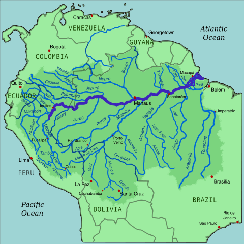
Map depicting the Amazon River drainage basin with the Amazon River highlighted.
Drainage Network Hierarchy
The Amazon's drainage network follows a hierarchical structure, with the main stem supported by increasingly smaller tributaries. Thousands of first-order headwater streams drain individual hillslopes and forest patches across the basin. These feed into major tributaries, rivers like the Madeira (3,250 km/2,020 mi), Negro (2,250 km/1,400 mi), and Xingu (1,980 km/1,230 mi), each among the world's largest rivers in its own right. All of these ultimately feed the Amazon River itself, whose main stem integrates all tributary flows into a single channel carrying 209,000 cubic meters (7.4 million cubic ft) of water per second to the Atlantic.
Amazonian waters exhibit remarkable chemical diversity, generally classified into whitewater, blackwater, and clearwater rivers depending on their source region and dissolved constituents; our Amazon Biome article covers this classification and the specialized ecosystems each water type supports in greater depth. In basin-wide hydrological terms, the practical consequence of this chemistry is straightforward: whitewater rivers like the main stem, Madeira, and Ucayali carry heavy sediment loads of 200-400 mg/L from the young Andes, while blackwater rivers like the Rio Negro, the world's largest blackwater river, and clearwater rivers draining the ancient Brazilian and Guiana shields carry comparatively little sediment at all, a distinction that shapes everything from floodplain fertility to river navigability throughout the basin.
Seasonal Hydrological Cycles
The basin experiences complex seasonal variations driven by precipitation patterns across its vast area. Water levels fluctuate 10-15 m (33-49 ft) annually in many areas, with peak-flow timing varying considerably across the basin: northern tributaries typically peak during June-August, while southern tributaries peak during February-April. During these peak floods, normally separate river systems may connect through temporary channels, allowing fish migration and genetic exchange between populations that remain isolated the rest of the year. Beneath all of this, the basin also contains massive groundwater reserves, with some estimates suggesting underground water storage equivalent to 20 years of the Amazon River's total flow.
Topographical Diversity
Despite its reputation as a flat lowland, the Amazon Basin contains remarkable topographical diversity. Its western margins, along the Andean foothills, reach elevations of 500-1,000 m (1,640-3,280 ft), creating steep gradients and rapid streams that differ greatly from the basin's interior. The central lowlands, by contrast, lie mostly below 200 m (656 ft) in elevation, with gradients as gentle as 2 cm per kilometer (1 in per mile) across vast stretches. Scattered across the basin, ancient rock formations create isolated shield uplands, including the Guiana Shield's tepuis, which rise to over 3,000 m (9,840 ft) and host unique endemic ecosystems entirely disconnected from the surrounding lowland forest.
Over millions of years, water action has produced a distinctive set of landforms across the basin. Floodplains, covering some 150,000 sq km (58,000 sq mi) in total, are among Earth's most dynamic landscapes, transformed twice yearly by the flood pulse. Step-like terraces along river valleys record past flood levels and climate conditions reaching back thousands of years. Abandoned river channels form thousands of crescent-shaped oxbow lakes, which serve as fish refugia and biodiversity hotspots in their own right. And natural levees along the rivers create elevated areas that remain above flood levels even at peak water, supporting plant communities distinct from the surrounding floodplain.
The Basin as a Weather Generator
Like the rainforest and biome it contains, the Amazon Basin functions as a massive atmospheric water recycling system, generating roughly half of its own precipitation through forest evapotranspiration and sending moisture thousands of kilometers across the continent as atmospheric rivers, a process covered in more mechanistic depth in our Amazon Rainforest and Amazon Biome articles. At the basin scale, this recycling also has real consequences for regional climate more broadly: the basin's vast water surfaces and vegetation cover moderate temperature extremes across the region, vegetation growth in turn responds to the precipitation this recycling generates, feeding back into basin-wide carbon storage, and the varying reflectivity of different land cover types across the basin, water, forest, and cleared land alike, shapes local and regional temperature patterns in ways scientists are still working to quantify fully.
Aquatic Species Richness
The Amazon Basin supports the world's most diverse freshwater fish fauna, with over 3,000 described species and possibly as many as 5,000 in total. Entire fish families, including the Arapaimidae (arapaimas) and many characid groups, exist only in Amazonian waters. Species range from tiny tetras up to the 200-kg (440-lb) pirarucu (Arapaima gigas), the world's largest scaled freshwater fish, and many species time their reproduction directly to the flood cycle, using the flooded forest itself as a nursery for juvenile fish.
Floodplain and Terrestrial-Aquatic Connections
The basin's extensive floodplains support ecological communities adapted specifically to the annual flood-drought cycle. Grass species like Echinochloa polystachya form vast floating meadows during high-water periods, while flood-adapted trees such as Cecropia and Salix can survive months of complete submersion through specialized root systems and metabolic adaptations. Seasonal lakes and marshes formed by the flood pulse provide critical habitat for fish spawning and bird feeding throughout the wet season.
The basin's terrestrial and aquatic systems interact in ways that blur the line between the two. Over 200 fish species feed directly on fruits and seeds from the flooded forest, effectively serving as seed dispersers for terrestrial plants in a role usually associated with birds and mammals. Seasonal floods transport nutrients back and forth between terrestrial and aquatic systems, supporting productivity in both, and the dynamic interface between land and water throughout the floodplain creates a shifting mosaic of microhabitats that supports specialized species communities found nowhere else in the basin.
Indigenous River Cultures
For over 11,000 years, human societies have adapted to the basin's hydrological rhythms. Indigenous groups practice várzea agriculture, planting crops directly on the fertile floodplain soils exposed during low-water periods, and traditional knowledge throughout the basin includes a sophisticated understanding of seasonal navigation routes, reading water levels, and predicting flood timing well in advance. Indigenous communities have also developed sustainable fishing practices refined over centuries, including seasonal restrictions, species-specific techniques, and rotational use of fishing grounds to prevent overexploitation of any single stretch of river.
Riverine Cities and Transportation
Modern human settlement across the basin still reflects its hydrological geography as directly as it did centuries ago. Major cities including Manaus, Iquitos, and Leticia developed as river ports and remain transportation and commerce hubs today, while ribeirinho, or riverbank, communities throughout the basin practice mixed economies combining fishing, small-scale agriculture, and forest product extraction. These riverine cities also face distinctly aquatic urban challenges, from seasonal flooding to water treatment and waste management in an environment where the river itself is never far from the front door.
The basin's river system serves, in effect, as South America's longest highway network. Ocean-going vessels can reach Manaus, 1,500 km (930 mi) inland, making it one of the world's most inland major ports despite its deep continental location. Smaller boats connect thousands of riverside communities beyond that point, carrying people, goods, and services throughout the basin's interior, and this river-based trade network integrates the Andean highlands with the Amazonian lowlands economically, linking ecological zones that would otherwise remain largely isolated from one another.
Deforestation and Infrastructure Pressures
Forest clearing throughout the basin creates cascading hydrological effects that extend well beyond the cleared area itself. Deforested land releases far less water vapor than intact forest, potentially reducing regional precipitation by 10-20% in affected areas; without forest canopy and root systems to intercept rainfall, more precipitation becomes direct runoff, increasing both flood peaks and erosion downstream; and that erosion in turn increases river sedimentation, affecting aquatic habitats and, in some stretches, river navigation itself.
Large-scale infrastructure compounds these pressures further. Over 150 hydroelectric dams are planned or under construction on Amazon tributaries, a scale of development that could fragment river systems and alter flood cycles across large portions of the basin; channel deepening and straightening projects for navigation change natural flow patterns in more localized but still consequential ways; and large-scale mining operations affect water quality and sediment loads in the tributary systems where they operate. Climate change compounds all of this: model projections point to more intense dry seasons and warming waters that could exceed thermal tolerance limits for many fish species, alongside a likely increase in the frequency of both severe droughts and intense floods, either of which can disrupt the basin's ecosystems and the human communities that depend on them.
Managing a Basin Shared by Nine Countries
Effective basin management requires international cooperation across nine countries with varying priorities and capacities, coordinated largely through the Amazon Cooperation Treaty Organization, whose broader diplomatic role, including its connection to the 2025 COP30 summit in Belém, is covered in our Amazônia overview. At the basin scale specifically, that cooperation matters because fish populations migrate across multiple national borders and require coordinated conservation, and because pollution introduced in one country's territory inevitably affects downstream nations, making basin-wide environmental standards a practical necessity rather than an abstract diplomatic goal.
Managing a watershed of this size and complexity increasingly relies on quantifying its hydrological services to justify conservation investment, on adaptive management approaches flexible enough to accommodate natural variability and the added uncertainty of climate change, and on community-based conservation that draws on the detailed local knowledge riverine and Indigenous communities have accumulated over generations. Sophisticated monitoring increasingly underpins all of this: a basin-wide network of gauging stations tracks water levels, flow rates, and water quality, satellite remote sensing provides basin-wide data on land cover change, flood extent, and vegetation health, and ongoing biodiversity assessments continue to reveal the true extent of the basin's biological diversity, much of which likely remains undescribed.
Conclusion: The Basin's Global Significance
The Amazon Basin represents far more than a regional watershed—it is a planetary life-support system whose health affects global climate stability, freshwater resources, and biodiversity conservation. This vast hydrological network regulates continental weather patterns, stores massive amounts of carbon, and supports an estimated 10% of known species.
As human pressures and climate change increasingly stress this system, understanding the basin's integrated functioning becomes critical for developing effective conservation and management strategies. The basin's complexity means that local actions can have basin-wide consequences, while global changes manifest in local impacts throughout the watershed. Protecting the Amazon Basin requires recognizing it as an integrated geographic system where geological processes, hydrological cycles, ecological communities, and human societies interact across multiple spatial and temporal scales, a holistic perspective essential for ensuring that Earth's greatest watershed continues to support the incredible diversity of life it has nurtured for millions of years while providing critical services to humanity and the global environment.