Ecuador's Extraordinary Aquatic Tapestry: Between Two Oceans and the Equator
Ecuador's small yet highly diverse territory includes some of the world's most remarkable aquatic environments. Its unique position at the crossroads of the Andes, the Amazon rainforest, the Pacific plain, and the Galápagos Islands creates a vast diversity of water bodies that support high biodiversity.


Equatorial Waters: A Journey Through Ecuador's Extraordinary Aquatic Landscapes
Ecuador's compact yet incredibly diverse territory, spanning just 283,561 km² (109,484 sq mi), encompasses one of the world's most remarkable concentrations of aquatic environments. Straddling the equator and situated between the Pacific Ocean and the Amazon Basin, this South American nation boasts glacial lakes atop volcanic peaks, pristine Amazon tributaries flowing through primary rainforest, cloud forest streams cascading down misty mountain slopes, and coastal mangrove estuaries teeming with marine life. The country's unique position at the intersection of major geographical features—the Andes Mountains, the Amazon rainforest, the Pacific coastal plain, and the isolated Galápagos Islands—creates an extraordinary diversity of water bodies that support some of Earth's highest levels of biodiversity per unit area. From the snow-fed lagoons of Cotopaxi at 4,000 m (13,123 ft) elevation to the depths of the Mariana Trench off the Galápagos at over 3,000 m (9,843 ft) below sea level, Ecuador's aquatic landscapes represent a microcosm of global hydrological diversity compressed into a space smaller than the state of Nevada.
The Andean Cordillera: Volcanic Waters and Highland Lakes
The Ecuadorian Andes, known locally as the Cordillera, divides into two parallel ranges separated by a high-altitude valley system called the Avenue of the Volcanoes. This dramatic topography, featuring over 50 volcanic peaks including several exceeding 5,000 m (16,404 ft), creates a complex network of crater lakes, glacial lagoons, and highland watersheds that serve as the headwaters for rivers flowing both eastward to the Amazon and westward to the Pacific.
Quilotoa, a water-filled volcanic crater located 3,914 m (12,841 ft) above sea level, exemplifies the region's unique volcanic hydrology. The nearly circular lake, measuring 3 km (1.9 mi) in diameter with a maximum depth of 250 m (820 ft), contains mineral-rich waters that shift from deep green to brilliant turquoise depending on light conditions and algal activity. The lake's isolated ecosystem supports specialized microorganisms that are adapted to high altitudes and volcanic chemistry.
The Mojanda Lakes complex, comprising Caricocha, Yanacocha, and Warmikaka, is situated within an ancient volcanic caldera at an elevation of 3,720 m (12,205 ft). These interconnected water bodies demonstrate how volcanic activity creates natural reservoir systems that regulate regional water supplies and support unique páramo ecosystems, characterized by cushion plants and specialized high-altitude fauna.
Cotopaxi National Park contains numerous glacial and volcanic lakes, including Limpiopungo Lagoon at 3,800 m (12,467 ft), which provides critical habitat for Andean waterfowl while serving as a natural laboratory for studying high-altitude aquatic ecology. The páramo wetlands surrounding these highland water bodies function as natural sponges, storing precipitation and gradually releasing water to lower elevations.
Amazon Basin: The Eastern Watershed
Eastern Ecuador encompasses approximately 48% of the country's territory within the Amazon Basin, containing pristine rivers, oxbow lakes, and wetland systems that support extraordinary biodiversity. The region's water bodies serve as critical components of the broader Amazon hydrological cycle, maintaining distinct characteristics due to the influence of the Andes and local geological conditions.
The Napo River, Ecuador's largest Amazon tributary, flows 1,075 km (668 mi) from Andean headwaters to its confluence with the Amazon River in Peru. Within Ecuador, the Napo drains 100,000 km² (38,610 sq mi) and maintains an average flow of 2,000 m³/s (70,629 ft³/s), making it one of the Amazon's most significant tributaries. The river's meandering course creates extensive floodplains, oxbow lakes, and wetland complexes that support diverse fish populations and serve as nursery areas for numerous aquatic species.
The Pastaza River system, originating from highland sources including the Chambo and Patate rivers, demonstrates the hydrological connection between Andean and Amazonian ecosystems. The river flows eastward through dramatic Andean gorges before entering the Amazon lowlands, where it creates extensive wetland systems supporting Indigenous communities and pristine rainforest ecosystems.
Cuyabeno Wildlife Reserve protects 603,380 hectares (1,491,000 acres) of pristine Amazon wetlands, including a complex network of rivers, lakes, and seasonally flooded forests. The reserve's aquatic systems support over 500 fish species, including several endemic taxa, while providing critical habitat for river dolphins, manatees, and numerous reptile species adapted to aquatic environments.
Yasuní National Park, recognized as a UNESCO Biosphere Reserve, contains extensive riverine systems including portions of the Napo, Tiputini, and Yasuní rivers. These water bodies flow through some of Earth's most biodiverse terrestrial ecosystems, with recent studies documenting over 2,000 tree species within the park, more than occur in all of North America.
Pacific Coast: Rivers, Estuaries, and Mangrove Systems
Ecuador's Pacific coastal region, despite receiving variable precipitation depending on latitude and elevation, contains significant river systems and coastal water bodies that support both human populations and unique marine-terrestrial ecosystems. The region's hydrology is strongly influenced by the El Niño-Southern Oscillation (ENSO), resulting in dramatic variations in water availability and ecosystem productivity.
The Guayas River system, Ecuador's most economically important waterway, drains 32,000 km² (12,355 sq mi) of coastal and highland territory before emptying into the Gulf of Guayaquil. The river, formed by the confluence of the Daule and Babahoyo rivers, flows past Ecuador's largest city, Guayaquil, and supports extensive agricultural activities, industrial development, and commercial shipping.
The Esmeraldas River, flowing 210 km (130 mi) from Andean headwaters to the Pacific Ocean, demonstrates the hydrological connections between highland and coastal ecosystems. The river's watershed encompasses a diverse range of environments, from cloud forests to tropical dry forests, supporting a varied fish population and providing water for coastal communities.
Extensive mangrove systems line Ecuador's northern and central coast, creating unique brackish water environments that serve as nurseries for marine species while protecting coastal areas from erosion and storm damage. The Cayapas-Mataje Ecological Reserve protects 51,300 hectares (126,760 acres) of mangrove forests and associated aquatic habitats, supporting populations of crocodiles, manatees, and numerous fish species adapted to estuarine conditions.
Galápagos Islands: Isolated Marine and Freshwater Systems
The Galápagos Islands, situated 1,000 km (621 mi) west of Ecuador's mainland, feature unique freshwater and marine environments that have evolved in isolation, supporting numerous endemic species. The archipelago's volcanic origin and oceanic position create distinctive hydrological conditions not found elsewhere on Earth.
Freshwater resources on the islands are extremely limited, consisting primarily of seasonal pools, volcanic crater lakes, and underground freshwater lenses. El Junco Lagoon on San Cristóbal Island represents the archipelago's only permanent freshwater lake, situated in a volcanic crater at an elevation of 700 m (2,297 ft) and supporting endemic plant species. It serves as a critical water source for native wildlife.
The marine environment surrounding the Galápagos benefits from the convergence of several ocean currents, including the cold Humboldt Current, the warm Panama Current, and the Equatorial Countercurrent. These current systems create upwelling zones that support extraordinary marine productivity and biodiversity, including populations of marine iguanas, flightless cormorants, and Galápagos penguins found nowhere else on Earth.
Highland Valley Systems: Inter-Andean Watersheds
The inter-Andean valley system, situated between Ecuador's eastern and western Cordilleras, contains important river systems and wetland areas that support both agricultural activities and urban populations. These valleys, ranging in elevation from 1,500 to 3,000 m (4,921 to 9,843 ft), experience temperate climates and contain some of Ecuador's most fertile soils.
The Chota Valley, Ecuador's lowest inter-Andean depression at 1,500 m (4,921 ft), is home to the Chota River and its associated wetlands, which support unique dry forest ecosystems adapted to rain shadow conditions. The valley's water resources support agricultural activities, including the production of tropical fruits at relatively high altitudes.
Lake San Pablo, located near Otavalo at 2,660 m (8,727 ft) elevation, exemplifies the inter-Andean valley lake systems. The lake covers 6.5 km² (2.5 sq mi) and supports local tourism while providing water for surrounding agricultural communities. The lake's watershed includes cloud forest areas that capture atmospheric moisture and regulate regional water supplies.
Cloud Forest Streams and Montane Waters
Ecuador's extensive cloud forest ecosystems, located on both the eastern and western Andean slopes between 1,500 and 3,000 m (4,921 and 9,843 ft) in elevation, contain numerous small streams and seasonal water bodies that play a critical role in regional hydrology. These misty environments capture atmospheric moisture and gradually release water to both the Amazon and Pacific watersheds.
The Mindo Valley, located on the western Andean slopes, contains extensive cloud forest watersheds that support over 500 bird species while providing water for both local communities and downstream agricultural areas. The region's streams illustrate how cloud forest ecosystems function as natural water towers, capturing moisture from passing clouds and storing it in the forest soils and vegetation.
Podocarpus National Park, spanning both eastern and western Andean slopes in southern Ecuador, protects extensive cloud forest watersheds that serve as headwaters for both the Amazon and Pacific river systems. The park's aquatic environments support endemic fish species, underscoring the crucial role of cloud forests in protecting watersheds.
Urban and Agricultural Water Systems
Ecuador's water resources support over 17 million inhabitants, with major urban centers requiring sophisticated water management systems to ensure adequate supplies for domestic, industrial, and commercial uses. Quito, the capital city located at an elevation of 2,850 m (9,350 ft), obtains water from highland watersheds, including the Papallacta area, which requires extensive infrastructure to transport water across mountainous terrain.
Agricultural water use varies dramatically across Ecuador's diverse climatic zones. Highland valleys support temperate crops, including potatoes and vegetables, using rainfall and highland stream diversions, while coastal banana and cacao plantations rely on river diversions and seasonal precipitation patterns influenced by ENSO cycles.
The Guayas River basin supports Ecuador's largest agricultural region, with extensive rice cultivation dependent on seasonal flooding and controlled irrigation systems. Water management in the region requires balancing agricultural needs with urban water supply, industrial uses, and environmental protection requirements.
Hydroelectric Development and Energy Production
Ecuador's mountainous terrain and abundant precipitation create significant hydroelectric potential, with several major dam projects providing substantial portions of the nation's electricity supply. The Coca Codo Sinclair project, completed in 2016 on the Coca River, generates 1,500 megawatts of electricity while demonstrating both the opportunities and challenges of large-scale hydroelectric development in seismically active, biodiverse regions.
The Paute River system contains multiple hydroelectric facilities that collectively provide approximately 60% of Ecuador's electricity. These projects demonstrate how mountainous countries can utilize water resources for renewable energy production while managing environmental and social impacts.
Indigenous Water Rights and Traditional Management
Indigenous communities throughout Ecuador have maintained traditional relationships with water bodies for centuries, utilizing sustainable management practices. Amazonian groups, including the Shuar, Achuar, and Cofán peoples, have developed a sophisticated understanding of riverine ecosystems and seasonal patterns that inform both traditional livelihood practices and modern conservation efforts.
Highland Indigenous communities employ traditional water management techniques, including canal systems, terracing, and seasonal water distribution methods, which maximize efficiency while preserving the integrity of their ecosystems. These practices offer valuable lessons for modern water management in regions facing increasing pressure from climate change and population growth.
Climate Change Impacts and Vulnerabilities
Ecuador's water resources are facing increasing pressure from the impacts of climate change, including glacial retreat, altered precipitation patterns, and an increased frequency of extreme weather events. The country's tropical glaciers, including those on Cotopaxi, Chimborazo, and Cayambe, have retreated significantly over recent decades, affecting water supplies for highland communities and downstream ecosystems.
ENSO events, projected to intensify under climate change scenarios, create dramatic variations in coastal precipitation and river flows that challenge water management systems designed for historical climate patterns. The 2015-2016 El Niño event demonstrated the vulnerability of coastal communities and ecosystems to extreme precipitation variations.
Sea level rise and increased coastal erosion pose a significant threat to mangrove ecosystems and coastal freshwater supplies, particularly in low-lying areas where saltwater intrusion affects both surface and groundwater resources.
Biodiversity and Ecological Significance
Ecuador's water bodies support extraordinary biodiversity, with the country containing over 4,500 fish species—more than any other country of comparable size. Amazonian river systems support the highest freshwater fish diversity on Earth, while highland lakes contain numerous endemic species adapted to high-altitude conditions.
The country's position at the intersection of major biogeographical regions creates unique assemblages of aquatic species with origins in North America, South America, and the Galápagos. Many water bodies serve as stepping stones for species migration and genetic exchange between different biogeographical regions.
Aquatic ecosystems face numerous threats, including habitat destruction, pollution, invasive species, and climate change. The introduction of trout species in highland lakes has displaced native fish populations, while industrial and agricultural pollution affects water quality in developed river basins.
Economic Importance and Resource Management
Water resources underpin Ecuador's economy through agriculture, energy production, tourism, and industrial activities. The country's flower industry, concentrated in highland valleys, relies on pristine water supplies and controlled irrigation systems to produce high-quality exports for international markets.
Tourism based on Ecuador's aquatic environments generates significant revenue, with destinations including the Galápagos Islands, Amazon river systems, and highland volcanic lakes attracting visitors interested in biodiversity, adventure activities, and cultural experiences.
Oil extraction in the Amazon region creates tensions between economic development and watershed protection, with ongoing debates regarding the balance between resource extraction and environmental conservation in some of Earth's most biodiverse ecosystems.
Water Quality and Pollution Challenges
Rapid urbanization and industrial development pose significant challenges to water quality throughout Ecuador, particularly in the Guayas River basin and its surrounding major urban centers. Inadequate wastewater treatment infrastructure leads to contamination of surface water bodies, which serve as sources for downstream communities.
Mining activities, both large-scale and artisanal, pose significant threats to water quality in highland watersheds. Heavy metal contamination from mining operations affects both surface and groundwater resources, with particular concerns regarding mercury contamination from small-scale gold mining operations.
Agricultural runoff containing pesticides and fertilizers impacts water quality in both highland and coastal river systems, posing challenges to the health of aquatic ecosystems and human water supplies.
Conservation Efforts and Protected Areas
Ecuador has established extensive protected area systems that safeguard critical watersheds and aquatic ecosystems. The country's national park system protects approximately 20% of the national territory, including significant portions of major river basins and watershed areas.
International recognition of Ecuador's biodiversity encompasses multiple UNESCO designations, Ramsar wetland sites, and other conservation agreements, highlighting the global significance of the country's aquatic ecosystems.
Community-based conservation initiatives, particularly in Indigenous territories, provide successful models for integrating traditional knowledge with modern conservation science to protect water resources and their associated biodiversity.
Summary
Ecuador's water bodies represent an extraordinary concentration of global aquatic diversity, encompassing everything from glacial crater lakes atop active volcanoes to pristine Amazon tributaries flowing through primary rainforest, from high-altitude páramo wetlands to isolated oceanic islands surrounded by unique marine currents. The country's position straddling the equator and spanning multiple major biogeographical regions creates aquatic environments that support some of Earth's highest levels of biodiversity per unit area.
The nation's water resources demonstrate both natural abundance and vulnerability, with pristine watersheds in protected areas contrasting with the challenges of pollution and overuse in developed regions. Highland volcanic systems create unique chemical and thermal conditions that support specialized ecosystems, while Amazon tributaries maintain continental-scale ecological connections essential for biodiversity conservation.
Understanding and protecting Ecuador's diverse aquatic systems requires an integrated approach that recognizes the interconnections between highland watersheds, Amazon tributaries, coastal estuaries, and oceanic islands. Indigenous knowledge and traditional management practices offer valuable insights for sustainable resource use, while modern conservation science provides tools for monitoring and protecting the integrity of ecosystems.
Climate change impacts, including glacial retreat and altered precipitation patterns, create new challenges for water resource management that require adaptive strategies and international cooperation. The country's small size relative to its hydrological diversity makes it both vulnerable to global changes and valuable as a natural laboratory for studying aquatic ecosystem responses to environmental change.
Ecuador's water bodies continue to shape the nation's identity, economy, and environmental future while serving as critical components of global biodiversity conservation. The preservation of these aquatic resources represents both a national priority and an international responsibility, given their global significance for biodiversity conservation and climate regulation.
The extraordinary diversity compressed within Ecuador's compact territory demonstrates how geological position, topographical complexity, and climatic variation combine to create some of the Earth's most remarkable aquatic landscapes, which deserve protection and sustainable management for future generations.
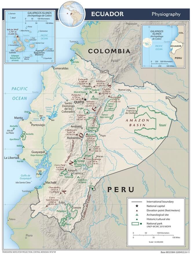
Physiographic map of Ecuador.
Comprehensive List of Significant Ecuadorian Water Bodies
Highland Lakes and Volcanic Waters
Quilotoa Crater Lake
- Size: 3 km (1.9 mi) diameter
- Location: Cotopaxi Province
- Elevation: 3,914 m (12,841 ft)
- Maximum depth: 250 m (820 ft)
Mojanda Lakes Complex
- Size: Caricocha 0.99 km² (0.38 sq mi), Yanacocha 0.12 km² (0.05 sq mi)
- Location: Imbabura Province
- Elevation: 3,720 m (12,205 ft)
Lake San Pablo (Lago San Pablo)
- Size: 6.5 km² (2.5 sq mi)
- Location: Imbabura Province, near Otavalo
- Elevation: 2,660 m (8,727 ft)
Limpiopungo Lagoon
- Size: 1.2 km² (0.46 sq mi)
- Location: Cotopaxi National Park
- Elevation: 3,800 m (12,467 ft)
Cuicocha Crater Lake
- Size: 3.2 km² (1.2 sq mi)
- Location: Imbabura Province, Cotacachi-Cayapas Reserve
- Elevation: 3,064 m (10,052 ft)
- Maximum depth: 148 m (486 ft)
Amazon Basin Rivers
Napo River (Río Napo)
- Length: 1,075 km (668 mi) total, ~400 km (248 mi) in Ecuador
- Location: Napo, Orellana, Sucumbíos Provinces
- Average flow: 2,000 m³/s (70,629 ft³/s)
- Drainage area: 100,000 km² (38,610 sq mi) in Ecuador
Pastaza River (Río Pastaza)
- Length: 710 km (441 mi) total, ~300 km (186 mi) in Ecuador
- Location: Tungurahua, Pastaza, Morona Santiago Provinces
- Average flow: 1,100 m³/s (38,850 ft³/s)
Santiago River (Río Santiago)
- Length: 280 km (174 mi) in Ecuador
- Location: Morona Santiago Province
- Average flow: 800 m³/s (28,252 ft³/s)
Morona River (Río Morona)
- Length: 240 km (149 mi) in Ecuador
- Location: Morona Santiago Province
- Average flow: 600 m³/s (21,189 ft³/s)
Zamora River (Río Zamora)
- Length: 180 km (112 mi)
- Location: Zamora-Chinchipe Province
- Average flow: 200 m³/s (7,063 ft³/s)
Coca River (Río Coca)
- Length: 150 km (93 mi)
- Location: Napo, Orellana Provinces
- Average flow: 300 m³/s (10,594 ft³/s)
Pacific Coast Rivers
Guayas River (Río Guayas)
- Length: 389 km (242 mi)
- Location: Guayas Province
- Drainage area: 32,000 km² (12,355 sq mi)
- Average flow: 860 m³/s (30,375 ft³/s)
Esmeraldas River (Río Esmeraldas)
- Length: 210 km (130 mi)
- Location: Esmeraldas Province
- Average flow: 283 m³/s (9,994 ft³/s)
Chone River (Río Chone)
- Length: 120 km (75 mi)
- Location: Manabí Province
- Average flow: 45 m³/s (1,589 ft³/s)
Daule River (Río Daule)
- Length: 245 km (152 mi)
- Location: Guayas Province
- Average flow: 400 m³/s (14,126 ft³/s)
Babahoyo River (Río Babahoyo)
- Length: 180 km (112 mi)
- Location: Los Ríos, Guayas Provinces
- Average flow: 350 m³/s (12,360 ft³/s)
Inter-Andean Valley Waters
Chota River (Río Chota)
- Length: 150 km (93 mi)
- Location: Imbabura, Carchi Provinces
- Elevation: 1,500 m (4,921 ft) at valley floor
Patate River (Río Patate)
- Length: 115 km (71 mi)
- Location: Tungurahua Province
- Average flow: 40 m³/s (1,413 ft³/s)
Chambo River (Río Chambo)
- Length: 85 km (53 mi)
- Location: Chimborazo Province
- Average flow: 25 m³/s (883 ft³/s)
Galápagos Islands
El Junco Lagoon
- Size: 0.5 km² (0.19 sq mi)
- Location: San Cristóbal Island
- Elevation: 700 m (2,297 ft)
- Only permanent freshwater lake in Galápagos
Darwin Lake
- Size: Seasonal, variable
- Location: Isabela Island
- Volcanic crater lake
Coastal Lagoons and Estuaries
La Segua Lagoon
- Size: 8 km² (3.1 sq mi)
- Location: Manabí Province
- Protected wetland area
Cube Lagoon
- Size: 4.2 km² (1.6 sq mi)
- Location: Esmeraldas Province
- Coastal lagoon system
Protected Wetland Areas
Cuyabeno Lagoon System
- Size: Multiple interconnected lagoons within 603,380 hectares (1,491,000 acres)
- Location: Sucumbíos Province
- Part of Cuyabeno Wildlife Reserve
Limoncocha Lagoon
- Size: 3.2 km² (1.2 sq mi)
- Location: Sucumbíos Province
- Ramsar Convention wetland site
Artificial Reservoirs
Paute River System Reservoirs
- Amaluza Reservoir: 19 km² (7.3 sq mi)
- Location: Azuay Province
- Hydroelectric complex
Coca Codo Sinclair Reservoir
- Size: 8.5 km² (3.3 sq mi)
- Location: Napo Province
- Capacity: 195 million m³ (158,180 acre-ft)
Springs and Thermal Waters
Papallacta Hot Springs
- Location: Napo Province
- Elevation: 3,300 m (10,827 ft)
- Thermal springs complex
Baños Thermal Springs
- Location: Tungurahua Province
- Elevation: 1,820 m (5,971 ft)
- Multiple thermal spring sources