Bolivia's Liquid Landscapes: Navigating the Diverse Water Bodies of the Landlocked Giant
Bolivia, a landlocked country in the heart of South America, presents a fascinating paradox in its water landscape. Despite lacking direct access to ocean waters, the country has an incredible variety of water bodies that have influenced its geography, ecology, and cultural history for thousands of years.


 via Wikimedia Commons")

 via Wikimedia Commons")
Aquatic Treasures of the Altiplano: Exploring Bolivia's Diverse Water Systems
Bolivia, a landlocked nation nestled in the heart of South America, presents a remarkable paradox in its hydrographic landscape. Despite lacking direct access to oceanic waters, the country boasts an extraordinary diversity of water bodies that have shaped its geography, ecology, and cultural heritage for millennia. From the mystical heights of Lake Titicaca to the vast salt flats of Uyuni, Bolivia's aquatic treasures tell a compelling story of geological evolution, climatic adaptation, and human civilization.
The water systems of Bolivia are organized into three distinct drainage basins, each with unique characteristics and ecological significance. These basins encompass everything from ancient high-altitude lakes that have witnessed the rise and fall of civilizations to meandering rivers that carry the lifeblood of the Amazon basin. Understanding these water bodies provides crucial insights into Bolivia's environmental challenges, economic opportunities, and the delicate balance between human development and natural preservation.
The Three Drainage Basins of Bolivia
Bolivia's hydrographic network is divided into three major drainage systems, reflecting the country's diverse topographical and climatic conditions. The Amazon Basin dominates the northern and eastern regions, collecting water from the Andean slopes and channeling it toward the Atlantic Ocean through Brazil. The Río de la Plata Basin encompasses the southeastern plains, directing water toward the Atlantic through Argentina and Uruguay. The Central or Altiplano Basin represents a unique closed system where waters have no outlet to the sea, creating distinctive saline environments in the high plateau region.
Each drainage basin supports distinct ecosystems and presents different water management challenges. The Amazon Basin rivers flow through tropical lowlands rich in biodiversity, while the Altiplano Basin contains some of the world's highest navigable waters and most extensive salt flats. The Río de la Plata Basin includes important wetland systems that support both wildlife and agricultural activities.
Lake Titicaca: The Crown Jewel of Andean Waters
Perched at an elevation of 3,812 m (12,507 ft) above sea level, Lake Titicaca stands as the world's highest navigable lake for large vessels. This ancient body of water, believed to be approximately three million years old, spans the border between Bolivia and Peru, with 3,790 km² (1,464 sq mi) of its area located within Bolivian territory.
The lake's impressive dimensions include a total surface area of 8,372 km² (3,232 sq mi) and a maximum depth of approximately 281 m (920 ft). Titicaca consists of two sub-basins connected by the Strait of Tiquina, with the larger Lago Grande reaching maximum depths while the smaller Lago Pequeño remains relatively shallow.
Fed by numerous mountain streams and rivers, Lake Titicaca serves as the source of the Desaguadero River, which flows southward through the Altiplano. The lake's pristine waters support unique endemic species and sustain the livelihoods of Indigenous communities who have called its shores home for thousands of years. The Uros people continue to live on floating islands constructed from totora reeds, maintaining traditions that predate the Inca civilization.
Cultural and Historical Significance
Lake Titicaca holds profound cultural significance as the legendary birthplace of the Inca civilization and the center of the ancient Tiwanaku culture. Archaeological evidence around the lake reveals sophisticated agricultural terraces, ceremonial sites, and advanced hydraulic engineering, demonstrating the intimate relationship between these civilizations and their aquatic environment. The lake remains sacred to the Indigenous Aymara and Quechua communities, who continue to perform ceremonies and maintain spiritual connections to its waters.
The Altiplano's Saline Lakes and Salt Flats
The Altiplano, or high plateau, hosts a network of saline lakes and salt flats that represent some of Bolivia's most distinctive and economically important water bodies. These formations result from the region's enclosed drainage system, where mineral-rich waters accumulate and evaporate, leaving behind vast deposits of salt and other valuable minerals.
Salar de Uyuni: The World's Largest Salt Flat
The Salar de Uyuni, covering approximately 10,582 km² (4,086 sq mi), represents the world's largest salt flat. During the rainy season, this extraordinary landscape transforms into a vast mirror that perfectly reflects the sky, creating one of the planet's most surreal natural phenomena. The salt flat contains massive reserves of lithium, potassium, and other minerals that have significant economic implications for Bolivia's future development.
Beneath the crystalline salt crust lie brine pools containing an estimated 50-70% of the world's known lithium reserves. The extraction of these minerals presents both opportunities and challenges, as Bolivia seeks to balance economic development with environmental protection and Indigenous rights.
Lake Poopó and Uru Uru: Environmental Indicators
Lake Poopó and Lake Uru Uru, two saline lakes that formed part of an interconnected hydrological system, have experienced dramatic changes in recent decades. These shallow, brackish lakes have served as important indicators of climate change and human impact on the Altiplano's delicate water balance. Lake Poopó, once Bolivia's second-largest lake, has experienced severe shrinkage and periodic complete desiccation, highlighting the vulnerability of the region's water resources.
The fluctuations in these lakes affect local communities, wildlife populations, and mining operations that depend on stable water levels. The challenge of managing these systems requires balancing agricultural water usage, mining activities, and conservation efforts while adapting to changing precipitation patterns.
The Amazon Basin: Rivers of Life
The northern and eastern regions of Bolivia drain into the Amazon Basin through an intricate network of rivers that support the country's most biodiverse ecosystems. These waterways serve as transportation corridors, sources of fresh water, and habitats for countless species while playing crucial roles in regional and global climate regulation.
Major River Systems
The Beni, Mamoré, and Madre de Dios rivers represent the primary tributaries that carry Bolivian waters toward the Amazon. These rivers originate in the Andean foothills and wind through diverse landscapes including cloud forests, tropical rainforests, and seasonal wetlands. The Mamoré River, flowing northward through the country's central plains, eventually joins the Madeira River in Brazil, contributing to the Amazon's massive discharge into the Atlantic Ocean.
The Beni River system drains much of northern Bolivia, collecting water from numerous tributaries that support important protected areas and Indigenous territories. The river's seasonal flooding patterns create dynamic ecosystems that support both terrestrial and aquatic species while providing fertile soils for agriculture.
The Pantanal Connection
In southeastern Bolivia, the Paraguay River system connects the country to the world's largest tropical wetland, the Pantanal. The region features several shallow lakes, including Cáceres, Mandioré, Gaiba, and Uberaba, as well as the extensive Xarayes Swamps. These wetlands experience significant seasonal flooding that supports extraordinary biodiversity and provides crucial ecosystem services, including flood control, water purification, and carbon sequestration.
Environmental Challenges and Conservation
Bolivia's water bodies face numerous environmental pressures that threaten their ecological integrity and the communities that depend on them. Climate change affects precipitation patterns, glacier retreat reduces water supplies, and increasing human activities place stress on aquatic ecosystems.
Mining and Water Quality
Mining operations throughout Bolivia have a significant impact on water quality, resulting in acid mine drainage, heavy metal contamination, and altered hydrology. The extraction of minerals from the Altiplano's salt flats requires careful management to prevent contamination of groundwater and surface water systems. Traditional mining activities in the Andes contribute pollutants to rivers that flow into both the Amazon and Altiplano basins.
Agricultural Pressures
Expanding agriculture and changing land use patterns affect water availability and quality throughout Bolivia. Irrigation demands compete with urban and industrial water needs, while agricultural runoff contributes nutrients and chemicals to water bodies. The conversion of wetlands and forests for agricultural use reduces the natural water retention capacity of landscapes.
Climate Change Impacts
Rising temperatures and changing precipitation patterns particularly affect high-altitude water bodies and glacier-fed systems. The retreat of Andean glaciers reduces the long-term water supply for cities and agricultural areas while altering the timing and volume of river flows. Increased evaporation rates in the Altiplano intensify the concentration of salts and minerals in enclosed lakes.
Economic Importance and Water Management
Bolivia's water bodies provide essential resources for economic development, including hydroelectric power generation, mineral extraction, agriculture, and tourism. The management of these resources requires balancing competing uses while ensuring sustainable development that protects environmental quality and the rights of Indigenous peoples.
Hydroelectric Potential
The country's rivers offer significant potential for hydroelectric power generation, with several major projects planned or under construction. The development of this renewable energy source could reduce dependence on fossil fuels while providing electricity for domestic use and export. However, large-scale hydroelectric projects raise concerns about environmental impacts and effects on downstream communities.
Tourism and Recreation
Bolivia's unique water bodies attract international visitors seeking to experience landscapes found nowhere else on Earth. Lake Titicaca's cultural significance and natural beauty make it a premier destination, while the Salar de Uyuni's otherworldly appearance draws photographers and adventure travelers. Sustainable tourism development around these water bodies provides economic opportunities for local communities while generating revenue for conservation efforts.
Future Challenges and Opportunities
The future of Bolivia's water bodies depends on integrated management approaches that consider environmental, social, and economic factors. Developing sustainable water use practices, implementing effective pollution control measures, and adapting to the impacts of climate change require coordinated efforts among government agencies, local communities, and international partners.
Technological Solutions
Advanced water treatment technologies, remote sensing for monitoring water quality and quantity, and improved agricultural practices offer opportunities to reduce environmental impacts while maintaining economic benefits. The development of sustainable mining practices for lithium extraction could position Bolivia as a responsible supplier of materials essential for renewable energy technologies.
International Cooperation
Many of Bolivia's water bodies are shared with neighboring countries, requiring regional cooperation for effective management. Collaborative efforts to protect transboundary watersheds, mitigate pollution, and adapt to climate change can benefit all countries involved while preserving these valuable resources for future generations.
Summary
Bolivia's water bodies represent a remarkable collection of aquatic environments that reflect the country's diverse geography, complex history, and significant economic potential. From the ancient depths of Lake Titicaca to the crystalline expanses of the Salar de Uyuni, these waters have shaped civilizations, support extraordinary biodiversity, and continue to provide essential resources for modern Bolivia. The three major drainage basins create distinct hydrological systems that require tailored management approaches addressing unique challenges and opportunities.
The preservation and sustainable use of these water resources depend on striking a balance between environmental protection and economic development needs. Climate change, mining activities, agricultural expansion, and population growth present ongoing challenges that require innovative solutions and international cooperation. The cultural and spiritual significance of these waters to Indigenous communities adds another dimension to their value, extending beyond economic considerations.
Bolivia's liquid landscapes offer lessons about the intricate relationships between water, land, and human societies. The country's experience managing these diverse water bodies provides insights relevant to water resource management challenges worldwide. As Bolivia continues to develop economically while facing environmental pressures, the wise stewardship of its water bodies will remain crucial for the nation's prosperity and the well-being of all who depend on these precious resources.
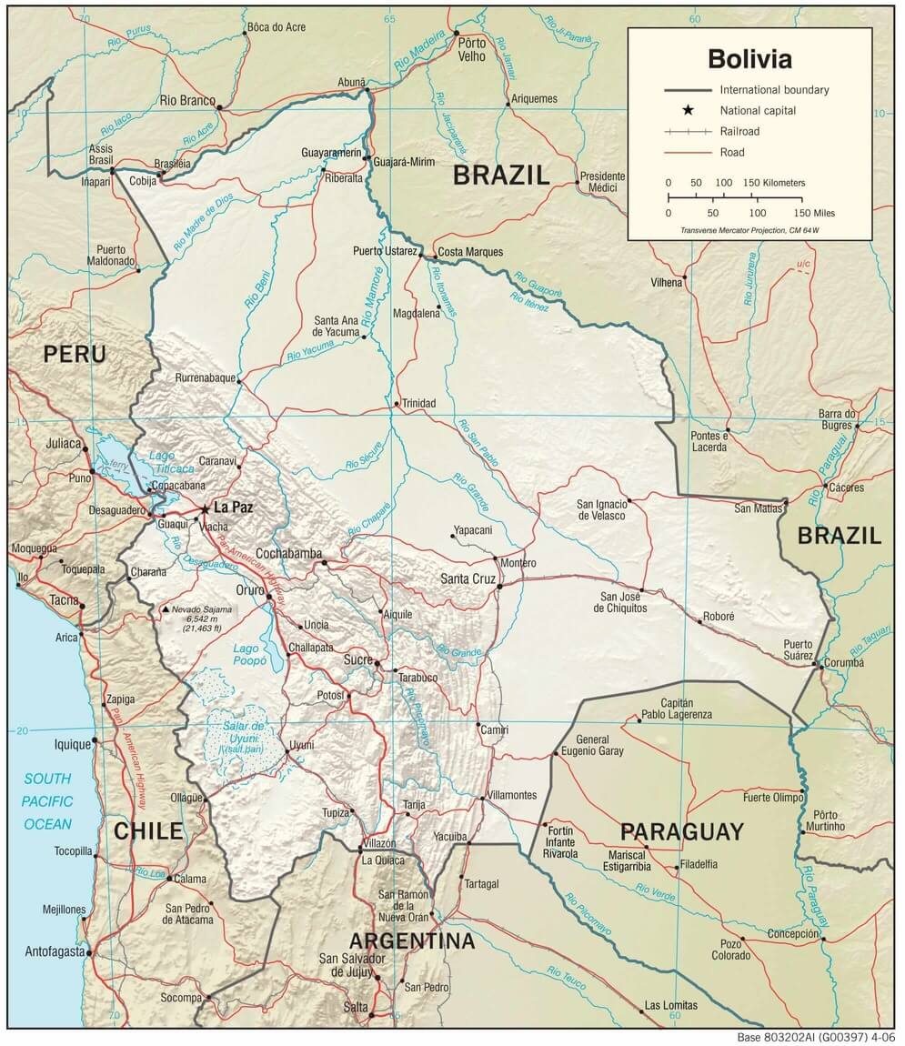
Physiographic map of Bolivia.
Notable Water Bodies of Bolivia
Lakes and Large Water Bodies
Lake Titicaca
- Size: 8,372 km² (3,232 sq mi) total; 3,790 km² (1,464 sq mi) in Bolivia
- Location: Altiplano, Bolivia-Peru border
- Maximum depth: 281 m (920 ft)
- Elevation: 3,812 m (12,507 ft)
Salar de Uyuni (Uyuni Salt Flats)
- Size: 10,582 km² (4,086 sq mi)
- Location: Altiplano, Potosí Department
- Type: Salt flat with seasonal flooding
Lake Poopó
- Size: Variable (historically up to 3,000 km²/1,158 sq mi)
- Location: Altiplano, Oruro Department
- Type: Saline lake, currently mostly dry
Salar de Coipasa
- Size: 2,218 km² (856 sq mi)
- Location: Altiplano, Oruro Department
- Type: Salt flat, the second largest in Bolivia
Lake Uru Uru
- Size: Variable (up to 214 km²/83 sq mi)
- Location: Altiplano, Oruro Department
- Type: Saline lake
Laguna Colorada
- Size: 60 km² (23 sq mi)
- Location: Eduardo Avaroa Reserve, Potosí Department
- Type: Mineral-rich lake, known for red coloration
Laguna Verde
- Size: 1.7 km² (0.66 sq mi)
- Location: Eduardo Avaroa Reserve, Potosí Department
- Type: High-altitude mineral lake
Laguna Blanca
- Size: Adjacent to Laguna Verde
- Location: Eduardo Avaroa Reserve, Potosí Department
- Type: High-altitude lake
Major Rivers
Mamoré River
- Length: 2,000 km (1,240 mi) total
- Location: Flows north through central Bolivia
- Basin: Amazon Basin
Beni River
- Length: 1,130 km (700 mi)
- Location: Northern Bolivia
- Basin: Amazon Basin
Paraguay River
- Length in Bolivia: 270 km (170 mi)
- Location: Southeastern Bolivia
- Basin: Río de la Plata Basin
Pilcomayo River
- Length: 1,100 km (680 mi) total
- Location: Southern Bolivia border
- Basin: Río de la Plata Basin
Desaguadero River
- Length: 436 km (271 mi)
- Location: Flows south from Lake Titicaca
- Basin: Central/Altiplano Basin
Madre de Dios River
- Length in Bolivia: 420 km (260 mi)
- Location: Northern Bolivia
- Basin: Amazon Basin
Guaporé River
- Length: 1,749 km (1,087 mi) total
- Location: Eastern Bolivia-Brazil border
- Basin: Amazon Basin
Wetland Systems
Pantanal (Bolivian portion)
- Size: Approximately 15,000 km² (5,792 sq mi)
- Location: Southeastern Bolivia
- Type: Seasonal tropical wetland
Xarayes Swamps
- Location: Eastern Bolivia, Pantanal region
- Type: Seasonal wetland system
Bañados del Izozog
- Size: 6,150 km² (2,375 sq mi)
- Location: Santa Cruz Department
- Type: Seasonal wetland
Seasonal and Smaller Water Bodies
Lake Cáceres
- Location: Pantanal region, southeastern Bolivia
- Type: Shallow seasonal lake
Lake Mandioré
- Location: Pantanal region, southeastern Bolivia
- Type: Shallow seasonal lake
Lake Gaiba
- Location: Pantanal region, southeastern Bolivia
- Type: Shallow seasonal lake
Lake Uberaba
- Location: Pantanal region, southeastern Bolivia
- Type: Shallow seasonal lake