Chile's Mountain Ranges: Backbone of a Nation
Chile has extraordinary mountain systems that form its geological backbone. The towering Andes dominate the eastern border, while the Coastal Range faces the Pacific. This unique geography features two distinct mountain chains that create diverse valleys, desert plateaus, and glaciated wilderness areas.

 https://www.flickr.com/photos/95874470@N08/8748085103")

 via Wikimedia Commons")

 — seen from Oncol Peak, Los Ríos Region, Chile - via Wikimedia Commons")
Chile's Cordilleras: A Journey Through South America's Western Spine
Chile, stretching like a narrow ribbon along South America's western coast, is defined by its extraordinary mountain systems that form the geological backbone of this remarkable nation. Dominated by the towering Andes Mountains along its eastern border and complemented by the parallel Coastal Range facing the Pacific, Chile presents a unique geography where dual mountain chains create diverse valleys, desert plateaus, and glaciated wilderness. From the world's highest volcanoes rising above the arid Atacama Desert in the north to the ice-covered granite spires of Patagonia in the south, Chile's mountain ranges tell a story of ongoing tectonic forces, dramatic climatic extremes, and remarkable human adaptation that spans over 4,300 km (2,672 mi) of some of Earth's most diverse and challenging terrain.
The Andes: Chile's Defining Spine
The Andes Mountains dominate Chile's eastern border, forming the longest continental mountain range in the world as they traverse the entire length of the country. In Chile, the Andes reach their most dramatic expression, with peaks soaring above 6,000 m (19,685 ft) and creating a formidable barrier between the Pacific coast and the interior of South America.
The Chilean Andes can be divided into several distinct sections, each with unique characteristics shaped by latitude, climate, and geological history. In the far north, the range splits into two parallel cordilleras – the Western Cordillera along the Chilean-Bolivian border and the Eastern Cordillera that extends into Bolivia and Argentina. This northern section, known as the Altiplano, features high-altitude plateaus punctuated by volcanic peaks and salt flats.
Central Chile hosts some of the Andes' most impressive summits, including Ojos del Salado, which at 6,893 m (22,615 ft) stands as the world's highest volcano and Chile's tallest peak. This region showcases the range's volcanic nature, with numerous active and dormant volcanoes creating a landscape of snow-capped cones and ancient lava flows. The central Andes also contains Aconcagua, which, while technically in Argentina, influences the regional geography and weather patterns that affect Chilean territory.
The Coastal Range: Guardian of the Pacific
Running parallel to the Andes along Chile's Pacific coast, the Cordillera de la Costa (Coastal Range) forms a secondary but equally important mountain system. Though generally lower in elevation than the Andes, with peaks rarely exceeding 2,000 m (6,562 ft), the Coastal Range plays a crucial role in Chile's geography and climate.
The Coastal Range begins in the north near Arica and extends southward for approximately 1,000 km (621 mi) before disappearing into the sea near Valdivia, only to reemerge as islands in the archipelagic south. This range creates a series of coastal valleys and terraces that have become some of Chile's most productive agricultural regions, particularly famous for wine production in the Central Valley.
The interaction between the Coastal Range and the Pacific Ocean creates unique microclimates that support a diverse array of ecosystems. In the north, the range contributes to the formation of the Atacama Desert by blocking moisture from the Pacific, while in central regions, it moderates temperatures and creates the Mediterranean climate that characterizes Chile's heartland.
Regional Variations: A Tapestry of Mountain Landscapes
Northern Chile: Desert Peaks and High Plateaus
Northern Chile's mountain landscape is characterized by extreme aridity and high elevation. The Andes here form part of the Central Volcanic Zone, featuring numerous stratovolcanoes that rise from the high plateau known as the Puna de Atacama. These mountains, including Llullaillaco (6,739 m/22,110 ft) and Licancabur (5,916 m/19,409 ft), are among the world's highest volcanoes and showcase the raw power of tectonic forces in one of Earth's driest environments.
The desert mountains of northern Chile present a moonscape of volcanic cones, salt flats, and mineral-rich formations. The absence of vegetation reveals the geological structure in stark detail, creating a landscape that seems almost extraterrestrial. These peaks are repositories of valuable minerals, including copper, lithium, and precious metals that form the backbone of Chile's economy.
Central Chile: The Mediterranean Andes
Central Chile's mountains enjoy a Mediterranean climate that supports both agriculture and dense population centers. The Andes here are characterized by dramatic elevation changes, with peaks rising directly from fertile valleys to snow-covered summits. This region contains some of Chile's most accessible high peaks and is home to numerous ski resorts and mountain communities.
The central Andes are geologically complex, featuring both volcanic and sedimentary formations. The presence of glaciers on higher peaks provides crucial water resources for Chile's agricultural heartland and major cities, including Santiago, which sits in a basin surrounded by towering peaks.
Southern Chile: Patagonian Wilderness
Southern Chile's mountains transform into a landscape of fjords, glaciers, and temperate rainforests. The Andes narrow considerably but maintain their dramatic character, with peaks like Cerro Torre and Fitz Roy (shared with Argentina) representing some of the world's most challenging mountaineering objectives.
The Patagonian Andes are heavily glaciated, with the Southern Patagonian Ice Field being the largest ice mass in the Southern Hemisphere outside of Antarctica. These ice fields feed numerous glaciers that flow toward both the Pacific Ocean and inland lakes, creating a dynamic landscape of ice, rock, and pristine wilderness.
Geological Origins and Ongoing Evolution
Chile's mountains are products of the ongoing collision between the Nazca Plate and the South American Plate, a process that continues to shape the landscape today. This tectonic activity manifests in frequent earthquakes, active volcanism, and ongoing uplift of the mountain ranges.
The formation of the Andes began approximately 200 million years ago, but the current configuration is much younger, with most of the significant uplift occurring within the last 50 million years. This relatively recent formation explains the Andes' dramatic relief and ongoing instability, as the mountains continue to rise while being eroded and shaped by glacial activity.
Volcanic activity remains a defining characteristic of Chilean mountains, with over 2,000 volcanoes identified along the country's length, including 500 potentially active systems. This volcanism has created fertile soils in many regions while also posing ongoing hazards to human populations.
Climate and Ecological Diversity
Chile's mountain ranges create dramatic climatic gradients that support an extraordinary biodiversity, despite the country's relatively narrow width. The Andes act as a climatic barrier, capturing moisture from both Pacific and Atlantic weather systems and creating distinct ecological zones at different elevations.
In the north, high-altitude ecosystems support specialized plant and animal communities adapted to extreme conditions. Vicuñas, flamingos, and unique plant species thrive in environments that would be hostile to most life forms. The central mountains support temperate forests and alpine meadows, while the southern ranges host some of the world's last remaining temperate rainforests.
The elevation gradients in the Chilean mountains create vertical ecological zones, ranging from coastal scrublands to temperate forests, alpine tundra, and permanent ice fields. These zones compress tremendous biological diversity into relatively small geographic areas, making Chile's mountains hotspots of endemic species and ecological research.
Human Interaction and Cultural Significance
Chile's mountains have profoundly shaped human settlement patterns and cultural development. Indigenous peoples, including the Mapuche, Aymara, and others, developed sophisticated adaptations to mountain environments, from high-altitude agricultural techniques to complex trade networks that crossed the Andes.
Modern Chile's economy remains intimately connected to its mountains, which contain vast mineral wealth, including the world's largest copper reserves. Mountain regions also provide hydroelectric power, water resources, and increasingly important tourism opportunities. Cities like Santiago illustrate the challenges and opportunities of living in mountain environments, where air quality issues are exacerbated by topographic inversion, while nearby peaks offer abundant recreational opportunities.
The mountains serve as natural borders and have influenced Chile's unique national identity as a country isolated by geography but enriched by the resources and beauty of its dramatic landscape. Mountain communities maintain distinct cultural traditions while adapting to modern economic pressures and climate change.
Conservation and Future Challenges
Chile's mountain ecosystems face numerous pressures from climate change, mining activities, and increasing human development. Glacial retreat threatens the water supplies of millions of people, while changing precipitation patterns impact both natural ecosystems and agricultural productivity.
Conservation efforts focus on protecting key mountain ecosystems through national parks and reserves, though enforcement and funding remain challenges. The establishment of large protected areas in Patagonia, supported by international conservation organizations, represents significant progress in preserving mountain wilderness.
Mining activities, while economically crucial, present ongoing environmental challenges in mountain regions. Balancing resource extraction with environmental protection requires careful management and increasingly sophisticated technology to minimize ecological impacts.
Conclusion: Mountains as National Identity
Chile's mountain ranges represent far more than geological formations; they embody the nation's character, challenges, and possibilities. From the mineral wealth that drives economic development to the recreational opportunities that enhance quality of life, from the water resources that sustain agriculture to the wilderness areas that preserve biodiversity, these mountains are integral to Chilean identity.
The dramatic landscapes created by tectonic forces continue to evolve, presenting both opportunities and challenges for future generations. As climate change alters mountain ecosystems and human populations grow, the relationship between Chileans and their mountains will undoubtedly evolve as well.
Understanding and appreciating Chile's mountain ranges requires recognizing their complexity as geological phenomena, ecological systems, economic resources, and cultural landscapes. These mountains have shaped a nation and continue to influence its destiny, standing as monuments to the power of natural forces and the resilience of life in extreme environments. In their peaks and valleys, glaciers and deserts, volcanoes and forests, Chile's mountains tell the story of our planet's dynamic past and uncertain future.

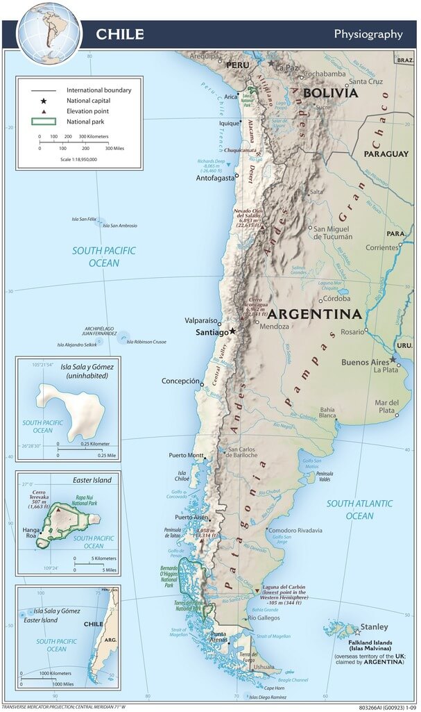
Topographical map of Chile.
Major Peaks of the Chilean Andes
Peaks Entirely Within Chile
Patagonian Region
- Monte San Valentín: 4,058 m (13,314 ft) - Highest peak in Chilean Patagonia
- Cerro Paine Grande: 2,884 m (9,462 ft)
- Monte Darwin: 2,500 m (8,202 ft)
- Cerro Macá: 2,300 m (7,546 ft)
- Volcán Hudson: 1,900 m (6,234 ft)
- Cerro Castillo Dynevor: 1,100 m (3,609 ft)
- Mount Tarn: 825 m (2,707 ft)
Northern Chile
- Acamarachi: 6,046 m (19,836 ft) - Volcano
- Polleras: 5,993 m (19,662 ft)
Peaks on the Chile-Argentina Border
Ultra-Prominent Peaks (6,000 m+)
- Ojos del Salado: 6,893 m (22,615 ft) - World's highest volcano & Chile's highest peak
- Nevado Tres Cruces: 6,749 m (22,142 ft) - South summit
- Llullaillaco: 6,739 m (22,110 ft) - Volcano
- Incahuasi: 6,620 m (21,719 ft)
- Tupungato: 6,570 m (21,555 ft) - Volcano
- Nacimiento: 6,492 m (21,299 ft)
- Sierra Nevada de Lagunas Bravas: 6,127 m (20,102 ft)
- Marmolejo: 6,110 m (20,046 ft)
- Socompa: 6,051 m (19,852 ft) - Volcano
High Peaks (5,000-6,000m)
- Falso Azufre: 5,890 m (19,324 ft) - Volcano
- Lastarria: 5,697 m (18,691 ft) - Volcano
- Cordón del Azufre: 5,463 m (17,923 ft)
- Cerro Escorial: 5,447 m (17,871 ft)
- Cerro Bayo: 5,401 m (17,720 ft)
- Maipo: 5,264 m (17,270 ft) - Volcano
Patagonian Peaks
- Tronador: 3,491 m (11,453 ft) - Volcano
- Cerro Fitz Roy: 3,405 m (11,171 ft) - Also known as Cerro Chaltén
Peaks on the Chile-Bolivia Border
Altiplano Volcanoes
- Parinacota: 6,348 m (20,827 ft) - Volcano
- Pomerape: 6,282 m (20,610 ft) - Volcano
- Acotango: 6,052 m (19,856 ft) - Volcano
- Licancabur: 5,916 m (19,409 ft) - Volcano with world's highest crater lake
- Paruma: 5,420 m (17,782 ft)
- Olca: 5,407 m (17,740 ft) - Volcano
- Michincha: 5,305 m (17,405 ft)
- Iru Phutunqu: 5,163 m (16,939 ft)
Chile physiographic map.