Panama's Aquatic Geography: From Canal to Coast
Panama is a strategic bridge between North and South America, connecting the Atlantic and Pacific. Its geography includes water bodies that shape its history, economy, and ecology. Water resources range from the Panama Canal to rivers, lakes, and coastal ecosystems.

 https://www.flickr.com/photos/orbanlopez/4315010686/")


 seen from the Bayano Dam, Panama - by Jcorrea21, CC BY-SA 3.0, via Wikimedia Commons")
The Isthmus of Waters: Panama's Strategic Position in Global Maritime Geography
Panama occupies one of the most strategically important positions in global maritime geography, serving as the narrow bridge between North and South America while connecting the Atlantic and Pacific oceans. This unique geographical situation has endowed the country with an extraordinary array of water bodies that have shaped its history, economy, and ecological diversity. From the engineering marvel of the Panama Canal system to the pristine rivers flowing through tropical rainforests, Panama's hydrological features represent a fascinating intersection of natural processes and human ingenuity. The country's water resources encompass artificial lakes that rank among the world's largest, extensive river networks draining into two major oceans, and diverse coastal ecosystems that support exceptional marine biodiversity.
The Panama Canal System: Engineering Waters
Lake Gatún: The Centerpiece of Global Commerce
Lake Gatún is a mostly freshwater reservoir located south of Colón, Panama, approximately 26 meters (85 feet) above sea level. It forms a major part of the Panama Canal by carrying ships 33 kilometers (21 miles) across the Isthmus of Panama. Covering 422 square kilometers (163 square miles), Lake Gatún is the largest body of water in Panama and was once the world's largest artificial lake upon its creation. The lake was formed by damming the Chagres River and its smaller tributaries at Gatún, with the dam completed in 1912.
The lake's creation required flooding vast areas of tropical rainforest, creating a unique ecosystem where several islands serve as important wildlife refuges. The submerged landscape has created an intricate network of channels and islands that support a diverse array of fauna, including howler monkeys, sloths, crocodiles, and over 300 bird species. The lake's strategic importance extends beyond its role in global shipping, as it serves as a crucial freshwater resource for the Panama Canal Authority and surrounding communities.
Lake Alajuela: The Supporting Reservoir
Lake Alajuela, also known as Lake Madden, is a reservoir formed by the Madden Dam that provides water to the Panama Canal. The Panama Canal Authority relies on Lake Alajuela for additional storage capacity to manage the navigable waters in Lake Gatún. This reservoir plays a critical role in maintaining water levels throughout the canal system, particularly during dry seasons when water conservation becomes essential for canal operations.
The lake's surrounding areas feature extensive tropical forests that serve as watersheds, protecting the water quality and ensuring consistent flow into the canal system. The reservoir's creation also resulted in the displacement of several indigenous communities, highlighting the complex social and environmental consequences of large-scale water management projects.
Natural Lakes and Reservoirs
Lake Bayano: The Largest Natural Lake
The Bayano Dam, constructed on the Bayano River and completed in 1976, created Bayano Lake, the largest natural lake in Panama. It serves multiple purposes, including hydroelectric power generation and supplying water to the Panama City metropolitan area. The lake covers approximately 350 square kilometers (135 square miles) and extends deep into the eastern provinces of Panama, creating a significant freshwater ecosystem that supports both commercial and recreational activities.
The lake's creation flooded extensive areas of tropical rainforest, similar to Lake Gatún, and also provided crucial infrastructure to meet Panama's growing energy demands. The surrounding areas have become popular destinations for fishing, particularly for tarpon and other sport fish, while the lake's shoreline supports diverse wildlife communities adapted to the reservoir environment.
River Systems and Drainage Patterns
Caribbean Drainage Basin
More than 150 rivers drain into the Caribbean, including the Chagres River (125 kilometers/78 miles), Changuinola River (110 kilometers/68 miles), Indio River (92 kilometers/57 miles), and Cricamola River (62 kilometers/38 miles). The Caribbean drainage basin encompasses the northern slopes of Panama's central mountain ranges and represents the country's most extensive river network.
The Chagres River holds particular significance as the primary water source for the Panama Canal system. There is a hydroelectric dam on the Chagres River, which originates in mountain cloud forests, underscoring the river's significance for both transportation and energy production. The river's watershed encompasses some of Panama's most pristine tropical rainforest ecosystems, protected within national parks and reserves.
The Changuinola River, flowing through the northwestern provinces, supports significant banana plantations and provides water for irrigation throughout the region. The river's lower reaches feature extensive wetlands that serve as crucial habitat for waterfowl and other wetland-dependent species.
Pacific Drainage Basin
The Pacific drainage basin, while smaller in total area than the Caribbean system, includes several important rivers that flow southward from the continental divide. These rivers typically exhibit more pronounced seasonal variations in flow, reflecting the influence of Panama's distinct wet and dry seasons.
Major Pacific-flowing rivers include the Tuira River, which drains much of the Darién Province and flows into the Gulf of San Miguel, and the Santa María River, which provides water for agricultural activities in the Azuero Peninsula. These rivers support diverse ecosystems ranging from montane cloud forests in their headwaters to extensive mangrove systems in their estuarine reaches.
Coastal Waters and Marine Environments
Pacific Coast
Panama's Pacific coastline extends approximately 1,700 kilometers (1,056 miles) and features diverse marine environments ranging from rocky headlands to extensive sandy beaches and mangrove-lined estuaries. The Gulf of Panama serves as the heart of maritime trade and biodiversity, representing one of the most ecologically productive marine areas in the eastern Pacific.
The Gulf of Panama encompasses approximately 2,400 square kilometers (927 square miles). It supports exceptional marine biodiversity, including humpback whales that migrate annually from Antarctic waters to breed in the warm tropical waters. The gulf's upwelling systems bring nutrient-rich waters to the surface, supporting abundant fish populations and making it one of Central America's most important fishing grounds.
Caribbean Coast
The Caribbean coastline stretches approximately 1,160 kilometers (721 miles) and features a markedly different character from the Pacific coast. The Caribbean waters are generally calmer and support extensive coral reef systems, particularly in the Bocas del Toro archipelago and around the Caribbean islands.
The Gulf of Darién, nestled between the Caribbean Sea and the dense tropical rainforests of Central and South America, represents one of the region's most significant yet lesser-known bodies of water. The gulf's extensive mangrove systems and river deltas create critical nursery habitats for marine species and support traditional fishing communities that have depended on these resources for generations.
Archipelagos and Island Waters
Bocas del Toro Archipelago
The Bocas del Toro archipelago comprises numerous islands and islets, surrounded by crystal-clear Caribbean waters that support some of Panama's most pristine coral reef ecosystems. The archipelago's lagoons and channels create protected waters that serve as crucial habitat for manatees, dolphins, and sea turtles.
The archipelago's unique geological history has created a diverse array of aquatic habitats, from shallow seagrass beds to deep-water channels that support different marine communities. The region's waters are particularly important for ecotourism, offering opportunities for snorkeling, diving, and wildlife observation.
Pearl Islands
The Pearl Islands, located in the Gulf of Panama, consist of over 200 islands and islets that create a complex network of coastal waters supporting diverse marine ecosystems. The islands' protected bays and channels provide crucial habitat for commercially important fish species, supporting both artisanal and recreational fishing activities.
The archipelago's waters have historical significance as the site of extensive pearl diving operations during the colonial period, which gave the islands their name. Today, the waters around the Pearl Islands support marine conservation initiatives and sustainable tourism development.
Wetland Systems and Biodiversity
Panama's wetland systems encompass approximately 1.8 million hectares (4.4 million acres) and include diverse habitats ranging from coastal mangroves to inland freshwater marshes. These systems play crucial roles in flood control, water purification, and carbon sequestration while supporting exceptional biodiversity.
The country's most significant wetland areas include the mangrove systems of the Gulf of Panama and the Gulf of Darién, the freshwater marshes surrounding Lake Gatún and Lake Bayano, and the extensive wetlands of the Darién Province. These ecosystems support numerous endangered species, including the Mesoamerican river turtle, spectacled caiman, and various species of waterfowl.
Hydroelectric Development and Water Management
Panama's mountainous terrain and abundant precipitation provide excellent conditions for hydroelectric development. The country currently operates several major hydroelectric facilities, with the largest being the Bayano hydroelectric complex, which provides approximately 270 megawatts of generating capacity.
Water management in Panama faces unique challenges due to the country's dependence on freshwater resources for canal operations. In a country with two distinct seasons – wet and dry – and water being the engine that drives the most valuable piece of infrastructure, water management is crucial. The Panama Canal Authority has implemented sophisticated water conservation measures and reservoir management systems to ensure adequate water supplies for canal operations while meeting other water demands.
Climate Change and Water Security
Climate change poses significant challenges to Panama's water resources, with projected changes in precipitation patterns potentially affecting canal operations and water availability. While drought is the defining story of the Panama Canal this year, others have been characterized by floods that bring a whole other set of problems, highlighting the complex relationship between climate variability and water management.
El Niño and La Niña phenomena significantly impact Panama's water resources, with El Niño events typically bringing drought conditions that reduce water levels in the canal system and affect hydroelectric generation. Conversely, La Niña events can produce excessive rainfall and flooding, creating different but equally challenging water management situations.
Marine Conservation and Protected Areas
Panama has established numerous marine protected areas to safeguard its coastal and marine water resources. These include the Coiba National Park, which protects one of the eastern Pacific's most pristine marine ecosystems, and the Bastimentos Marine National Park in the Bocas del Toro archipelago.
The country's marine conservation efforts focus on protecting critical habitats for endangered species, maintaining healthy fish populations for sustainable fisheries, and preserving coral reef ecosystems that are threatened by climate change and human activities. International cooperation plays a crucial role in these efforts, particularly for protecting migratory species that cross international boundaries.
Economic Importance and Maritime Trade
Panama's water bodies serve as the foundation for the country's economy, with the Panama Canal generating billions of dollars in annual revenue and supporting thousands of jobs. The canal's strategic importance has made Panama a major center for international shipping, banking, and logistics services.
The country's fisheries also make a significant contribution to the economy, with both Pacific and Caribbean waters supporting commercial fishing operations. The marine resources support both export-oriented fisheries and local food security, while recreational fishing and marine tourism provide additional economic benefits.
Summary
Panama's water bodies represent a remarkable convergence of natural processes and human engineering, creating one of the world's most strategically important hydrological systems. From the artificial lakes that power global commerce through the Panama Canal to the pristine rivers that flow through some of Central America's last remaining tropical rainforests, these water resources define Panama's identity as a maritime nation. The country's unique position between two oceans, combined with its mountainous terrain and tropical climate, has created diverse aquatic ecosystems that support exceptional biodiversity while providing essential services for human development.
The Panama Canal system, anchored by Lake Gatún and supported by Lake Alajuela, demonstrates humanity's ability to harness natural water resources for global benefit, while the country's extensive river networks and coastal waters remind us of the importance of preserving natural aquatic ecosystems. As climate change and growing water demands create new challenges, Panama's experience in managing complex water systems offers valuable lessons for sustainable water resource management in the 21st century. The future of Panama's water bodies depends on striking a balance between the needs of global commerce, local communities, and environmental conservation through innovative management approaches that recognize the interconnected nature of these vital aquatic resources.
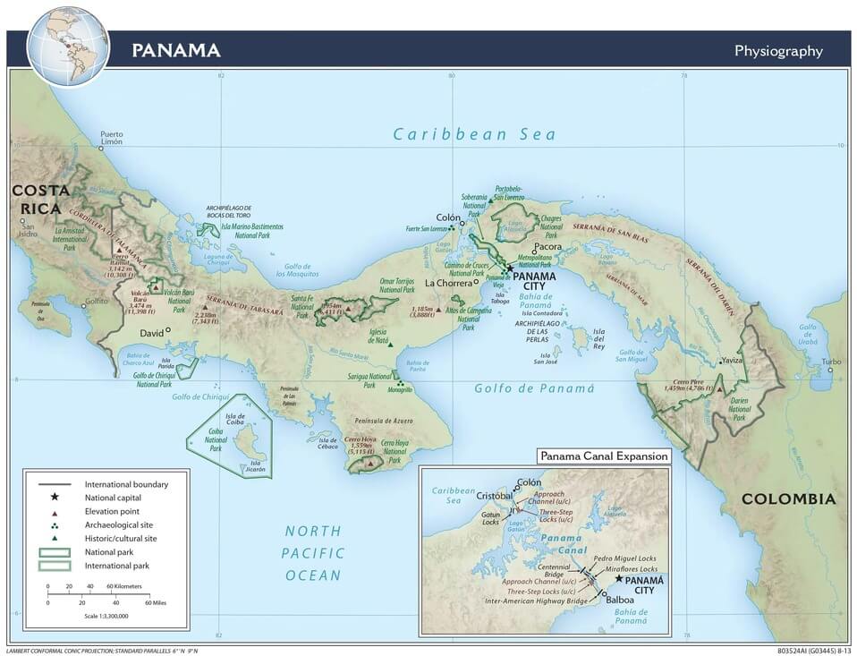
Panama physiographic map.
Notable Water Bodies of Panama
Major Lakes and Reservoirs
- Lake Gatún: 422 km² (163 sq mi), Central Panama Canal Zone
- Lake Bayano: 350 km² (135 sq mi), Eastern Panama
- Lake Alajuela (Lake Madden): 50 km² (19 sq mi), Central Panama Canal Zone
- Fortuna Lake: 12 km² (4.6 sq mi), Chiriquí Province
- La Yeguada Lake: 8 km² (3.1 sq mi), Veraguas Province
Major Rivers
- Chagres River: 125 km (78 mi), Central Panama to the Caribbean
- Changuinola River: 110 km (68 mi), Northwestern Panama to the Caribbean
- Indio River: 92 km (57 mi), Central Panama to the Caribbean
- Tuira River: 85 km (53 mi), Darién Province to the Pacific
- Bayano River: 80 km (50 mi), Eastern Panama to the Pacific
- Santa María River: 75 km (47 mi), Azuero Peninsula to the Pacific
- Cricamola River: 62 km (38 mi), Northwestern Panama to the Caribbean
Coastal Waters and Gulfs
- Gulf of Panama: 2,400 km² (927 sq mi), Pacific Ocean
- Gulf of Darién: 1,200 km² (463 sq mi), Caribbean Sea
- Gulf of San Miguel: 800 km² (309 sq mi), Pacific Ocean
- Chiriquí Gulf: 600 km² (232 sq mi), Pacific Ocean
- Mosquito Gulf: 350 km² (135 sq mi), Caribbean Sea
Archipelagos and Island Waters
- Bocas del Toro Archipelago: 250 km² (97 sq mi), Caribbean Sea
- Pearl Islands (Archipiélago de las Perlas): 1,340 km² (517 sq mi), Pacific Ocean
- San Blas Islands: 180 km² (69 sq mi), Caribbean Sea
- Coiba Island: 503 km² (194 sq mi), Pacific Ocean
- Azuero Peninsula Coastal Waters: 400 km² (154 sq mi), Pacific Ocean
Wetland Systems
- Darién Wetlands: 150,000 hectares (370,656 acres), Eastern Panama
- Gatún Lake Islands: 2,500 hectares (6,178 acres), Central Panama
- Gulf of Panama Mangroves: 45,000 hectares (111,197 acres), Pacific coast
- Caribbean Coastal Wetlands: 35,000 hectares (86,487 acres), Caribbean coast
Canal System Components
- Panama Canal: 82 km (51 mi), Atlantic to Pacific
- Gatún Locks: 3 chambers, Atlantic side
- Pedro Miguel Locks: 1 chamber, Pacific side
- Miraflores Locks: 2 chambers, Pacific side
- Culebra Cut: 13 km (8 mi), Central canal section