Landforms of Mexico

Marismas Nacionales: Mexico's Coastal Wetland Haven

The Marismas Nacionales Lagoon System is one of the most extensive and ecologically critical coastal wetlands along the Pacific coast in northwest Mexico. This unique ecosystem is a vital natural resource, distinguished by its dynamic wetland habitats, including estuaries, marshes, mangroves, and coastal lagoons. It is recognized as one of Mexico's most crucial mangrove systems, playing a critical role in sustaining biodiversity, protecting coastal areas, and mitigating the impacts of climate change.

Mexico's Sumidero Canyon and National Park: Nature's Grandeur Along the Grijalva River

Nestled in the southern expanse of Mexico, the Sumidero Canyon emerges as a captivating geological marvel. Sculpted over millennia by the unwavering power of the Grijalva River, this majestic canyon serves as a poignant testament to the raw forces of nature and the awe-inspiring beauty they can create. Within the bounds of the Sumidero Canyon National Park, a sanctuary of ecological importance and natural diversity unfolds.

Nevado de Toluca National Park: Mexico's High-Altitude Volcanic Wonderland

Nevado de Toluca National Park protects Mexico's fourth-highest mountain, a dramatic stratovolcano with twin crater lakes nestled within its ancient caldera. This sanctuary encompasses remarkable biodiversity across distinct elevation zones, from temperate forests of sacred fir and pine to high-altitude alpine grasslands supporting endemic species. Known to the Aztecs as "Xinantécatl", the mountain holds profound cultural significance as a sacred site where ancient peoples made ceremonial offerings. Today, the park attracts hikers, mountaineers, and researchers, though it faces growing threats that challenge the preservation of this extraordinary volcanic landscape.

Oblatos Canyon: A Natural Wonder of Mexico's Western Highlands

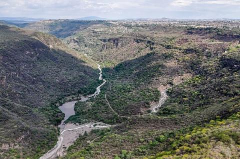
Oblatos Canyon, also known as Huentitán Canyon, is a breathtaking natural landmark located on the outskirts of Guadalajara in Jalisco, Mexico. Carved by the powerful Río Grande de Santiago, this majestic canyon serves as a sanctuary for diverse ecosystems, a hub for recreational activities, and a site of cultural and historical significance. Its dramatic landscapes, towering cliffs, and rich biodiversity have made it a favorite destination for adventurers, nature enthusiasts, and conservationists.

Paricutín Volcano: Mexico’s Youngest Volcanic Marvel

The Paricutín Volcano, located in Michoacán, Mexico, is one of the world's youngest and most studied volcanoes. Its sudden emergence in 1943 from a cornfield startled locals and scientists alike, marking a unique opportunity to observe the complete life cycle of a cinder cone volcano. Over nine years of continuous eruption, Paricutín buried villages and farmland under lava and ash, forever altering the landscape. The volcano, now dormant, stands as a testament to the immense geological forces in the region.

Pico de Orizaba: Mexico's Towering Natural Landmark

Pico de Orizaba, or Citlaltépetl, is the highest peak in Mexico and the tallest volcano in North America. Situated on the border of the Mexican states of Veracruz and Puebla, the inactive stratovolcano rises to an imposing height. Its prominence within the Trans-Mexican Volcanic Belt and its rich history in geological and cultural contexts make it a defining feature of the Mexican landscape. Its glaciers, towering presence, and role in indigenous mythologies further highlight the volcano's significance.

Revillagigedo Archipelago: Mexico’s Hidden Natural Treasure

The Archipiélago de Revillagigedo, located in the eastern Pacific Ocean, is a remarkable natural treasure. South-southwest of the Baja California Peninsula and west-southwest of Cape Corrientes on the Mexican mainland, this archipelago consists of volcanic islands declared a Marine Reserve and a National Park. They are recognized as a UNESCO World Heritage Site, reflecting its global significance. The four islands and their surrounding waters form a unique and pristine ecosystem.

Río Bravo del Norte: The Great River That Unites and Divides Two Nations

In the high peaks of Colorado's San Juan Mountains, where crystalline streams gather force from melting snowfields, one of North America's most culturally and politically significant waterways begins. Known as the Rio Grande in the United States and Río Bravo del Norte in Mexico, this continental river spans 3,051 km (1,896 mi) as it carves its path from alpine tundra to tropical delta, ultimately serving as the international boundary between the two nations.

Rio Grande / Río Bravo del Norte: A River, Two Names, One Shared Story

Known as the Rio Grande in the United States and the Río Bravo del Norte in Mexico, this 3,051-km (1,896-mi) river runs from Colorado's San Juan Mountains to the Gulf of Mexico, forming roughly 2,000 km (1,240 mi) of international border along the way. This overview treats the whole river and both nations' relationships to it on equal terms and serves as the primary reference for the river's US course, alongside a dedicated article covering its course through Mexico in greater depth.

San Carlos and Cerro Tetakawi: A Coastal Haven in Sonora

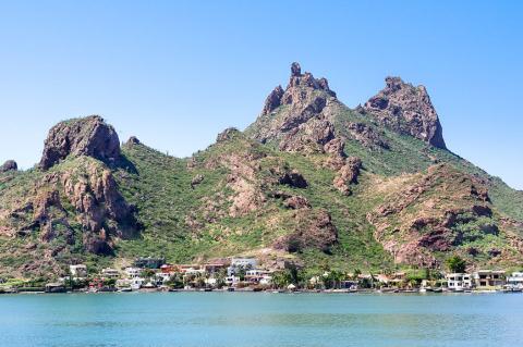
San Carlos, a picturesque coastal town in the Mexican state of Sonora, is celebrated for its stunning landscapes, azure waters, and vibrant marine life. Nestled along the Gulf of California, this charming destination is a haven for adventurers, beachgoers, and eco-tourists. Overlooking the town and standing as an iconic symbol of the region is Cerro Tetakawi, a dramatic peak offering breathtaking views and a profound connection to the area's natural heritage.