
The Peninsular Ranges System: A Geological and Ecological Marvel of Northwestern Mexico
The Peninsular Ranges System forms the mountainous backbone of Mexico's Baja California Peninsula, with six distinct ranges running 1,500 km from the US border to the peninsula's southern tip — home to ancient rock art, ancient pine forests over 600 years old, and the only wild population of California condors found anywhere outside the United States.


The Peninsular Ranges: Six Mountains, One Peninsula, and the Only Wild Condors Outside the US
The Peninsular Ranges System, running parallel to the Pacific Ocean, is a remarkable series of coastal mountain ranges that form the backbone of the Baja California Peninsula in northwestern Mexico. This rugged geological feature spans approximately 1,500 km (930 mi) from the international border with Southern California to the peninsula's southern tip, showcasing diverse ecosystems, geological formations, and endemic species.
Geographic Extent and Composition
The Peninsular Ranges System comprises six distinct mountain ranges dominated by Mesozoic granitic rocks. These ranges extend from approximately 150 m (500 ft) to 3,300 m (10,800 ft) above sea level and encompass a mosaic of desert, xeric shrubland, and temperate coniferous pine-oak forest ecoregions.
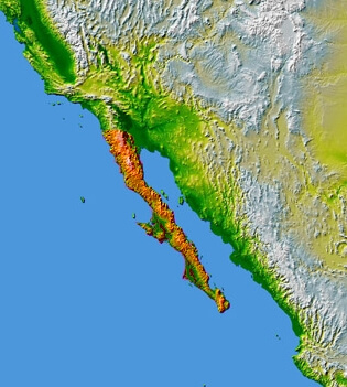
NASA topographic map of Baja California.
Sierra de Juárez
The northernmost range of the Peninsular Ranges System and of Mexico, the Sierra de Juárez, rises sharply from the eastern Sonoran Desert, reaching its highest peak at 1,980 m (6,500 ft) above sea level. The lower western slopes are part of the California coastal sage and chaparral sub-ecoregion, while the eastern slopes transition into the arid Sonoran Desert ecoregion, characterized by its unique desert flora.
The higher elevations of the Sierra de Juárez and those of the Sierra San Pedro Mártir to the south form part of the Sierra Juárez and San Pedro Mártir pine-oak forests ecoregion. This unique ecosystem is a "Sky Island," an elevated temperate forest surrounded by lower, more arid lands. Big sagebrush (Artemisia tridentata) is a common shrub in the understory of these coniferous forests.
Sierra de San Pedro Mártir
Acting as a drainage divide between waters flowing west into the Pacific Ocean and east into the Gulf of California, the Sierra de San Pedro Mártir is home to Picacho del Diablo ("Devil's Peak"), the highest point in the Baja California Peninsula at 3,096 m (10,157 ft) above sea level. This granitic mountain range is characterized by young, rocky soils that are poorly developed, shallow, and low in organic matter.
Sierra de San Pedro Mártir National Park, protected since 1947, is located within this range. It is known for its pine trees, including the towering sugar pine (Pinus lambertiana), which can reach up to 70 m (230 ft) in height and, in some stands, exceed 600 years in age, as well as unique granite rock formations. Additionally, the National Astronomical Observatory (Observatorio Astronómico Nacional), operated by Mexico's National Autonomous University, is located in the range at an elevation of 2,830 m (9,280 ft) above sea level, taking advantage of the clear skies and favorable atmospheric conditions.
The coniferous forests of the Sierra de San Pedro Mártir and Sierra de Juárez comprise a "Sky Island," an elevated temperate forest surrounded by lower, more arid lands. Dominant tree species include Parry pinyon (Pinus quadrifolia), Jeffrey pine (Pinus jeffreyi), lodgepole pine (Pinus contorta), sugar pine, white fir (Abies concolor), and incense cedar (Calocedrus decurrens). The herbaceous stratum is formed by Bromus grass species and big sagebrush, while epiphytes and fungi are abundant throughout the forests.
This same forested sky island shelters some of the range's most significant wildlife, among them mountain lions (Puma concolor), bobcats (Lynx rufus), coyotes, and desert bighorn sheep (Ovis canadensis nelsoni), whose sure-footed populations range across the park's granite outcrops. Most remarkably, the Sierra de San Pedro Mártir is home to the only wild population of the California condor (Gymnogyps californianus) found anywhere outside the United States. The species had disappeared from the range by around 1945, but a binational reintroduction program, launched in 2002 with birds from the Los Angeles Zoo and later joined by Mexico City's Chapultepec Zoo, has rebuilt a free-flying population of roughly 45 birds today, tracked by satellite telemetry and supported by researchers who have lived for years in the park's remote backcountry, without running water or electricity, to sustain the effort.
Sierra de San Borja
The Sierra de San Borja, also known as Sierra La Libertad, is located south of the Sierra de San Pedro Mártir and is the northernmost outpost of the "Great Mural" rock art in the central Baja California mountains. With its highest point at Cerro La Sandia (1,775 m or 5,823 ft above sea level), this nearly uninhabited range is characterized by desert vegetation. It lacks the pine-oak forests found in the higher and more humid mountain ranges to the north and south.
The Sierra de San Borja is the northernmost outpost of the "Great Mural" rock art, which consists of prehistoric paintings of humans and other animals, often larger than life-size, on the walls and ceilings of natural rock shelters. Tourists visit the San Francisco Borja Mission, founded in 1762, and the extensive prehistoric rock art scattered throughout the mountains.
Sierra de San Francisco
Situated north of San Ignacio, the Sierra de San Francisco is the northernmost of a series of volcanic ranges running the length of eastern Baja California Sur. Its rugged terrain, drained by steep canyons harboring mesquite forests and palm groves, forms the eastern edge of the Vizcaíno Desert and links the southern peninsula's tropical components with the temperate influences of the north. The Sierra de San Francisco vegetation is characteristic of the Baja California Desert ecoregion. The mountain range, along with the Tres Vírgenes volcanic complex and Sierra Guadalupe, forms the eastern edge of the Vizcaíno Desert and facilitates the transition between the tropical and temperate elements of the peninsula's flora and fauna.
The prehistoric rock art pictographs of the Cochimí people, known as the Rock Paintings of Sierra de San Francisco, are found within these mountains and are a UNESCO World Heritage Site. The El Vizcaíno Biosphere Reserve encompasses the Sierra de San Francisco, protecting its unique natural and cultural heritage.
Sierra de la Giganta
Rising abruptly from the Gulf of California (Sea of Cortez), the Sierra de la Giganta runs parallel to the southeastern coast of the Baja California Peninsula in Baja California Sur state. The highest point in the range is Cerro de la Giganta, at 1,176 m (3,858 ft) above sea level and near the city of Loreto. The range is riddled with canyons and caves, including Tabor Canyon, a natural landmark known for its natural swimming pools and steep walls suitable for climbing and abseiling.
The Sierra de la Giganta is predominantly dry (xeric) shrubland, with the Baja California Desert ecoregion covering the range's Pacific (western) slope and the Gulf of California xeric scrub ecoregion covering the Gulf (eastern) slope. However, valley streams with year-round water sustain palm oases, with groves of the native fan palm (Washingtonia robusta) and other moisture-loving plants.
The caves within the Sierra de la Giganta were once inhabited by the Guaycura, the region's first settlers. Their heritage is preserved in the numerous petroglyphs and cave paintings throughout the range.
Sierra de la Laguna
The southernmost range of the Peninsular Ranges System, the Sierra de la Laguna, is located at the southern end of the Baja California Peninsula. In prehistoric times, this range was an island, resulting in a distinctive flora and fauna with many endemic species and subspecies, including a local subspecies of Mexican piñon (Pinus cembroides subsp. lagunae) that dominates the higher elevations.
The vegetation in the Sierra de la Laguna is stratified by elevation, with the dry San Lucan xeric scrub ecoregion extending from sea level to 250 m (820 ft), followed by the Sierra de la Laguna dry forests ecoregion from 250 to 800 m (820 to 2,620 ft). Above 800 m (2,600 ft), the dry forests transition into the Sierra de la Laguna pine-oak forests, exploited commercially for timber. Cattle raising is also common in the oak woodland and dry forest zones.
The Sierra La Laguna Biosphere Reserve was designated in 2003 to protect these temperate woodlands, dry forests, and xeric shrublands, which are the most critical reproduction sites for Xantus's hummingbird (Basilinna xantusii), a species found nowhere outside the southern tip of Baja California Sur. Unfortunately, the Reserve also represents the least explored territory in Baja California Sur.
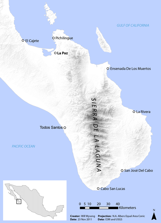
Map showing the Sierra de la Laguna Mountain Range.
Tres Vírgenes Volcanic Complex
Located about 36 km (22 mi) northwest of the town of Santa Rosalía in northeastern Baja California Sur, the Tres Vírgenes volcanic complex contains the only large stratovolcanoes on the Baja California Peninsula. This volcanic ridge, which extends towards the Guaymas Basin in the Gulf of California, is composed of three volcanoes aligned northeast to southwest: El Viejo, the oldest, made up of three lava domes; El Azufre, the next oldest, with a central dome and pyroclastic fans; and El Vírgen (or La Vírgen), the youngest and most conspicuous, comprising at least six cones.
The Tres Vírgenes volcanic complex is part of a more extensive geological system that has shaped the diverse landscapes and ecosystems of the Baja California Peninsula over millions of years. Volcanic activity and related processes have contributed to the formation of the rugged mountain ranges, unique rock formations, and varied soil types that characterize the region, influencing the distribution and diversity of flora and fauna within the Peninsular Ranges System.
Conclusion
The Peninsular Ranges System, stretching the entirety of the Baja California Peninsula, is a remarkable geological and ecological marvel that showcases the incredible diversity and complexity of northwestern Mexico's natural heritage. From the towering coniferous forests of the Sierra de Juárez and San Pedro Mártir in the north, now home to the only wild condors outside the United States, to the unique volcanic landscapes of the Sierra de San Francisco and Tres Vírgenes complex in the south, this mountain backbone has played a pivotal role in shaping the peninsula's intricate mosaic of ecosystems.
Each mountain range's varied topography, climatic conditions, and geological history has given rise to a rich tapestry of plant and animal life, including numerous endemic species found nowhere else on Earth, from Xantus's hummingbird in the far south to the reintroduced condors of the far north. The presence of ancient rock art and archaeological sites within these ranges further underscores the deep connection between the region's natural landscapes and rich cultural heritage.
As conservation efforts, including the binational condor recovery program, continue to protect and restore the unique ecosystems of the Peninsular Ranges System, these mountains stand as a testament to the resilience and adaptability of life in the face of the harsh desert environments surrounding them, and to what sustained international cooperation can achieve even for a species once gone from the wild entirely.